
Brisbane River
Encyclopedia
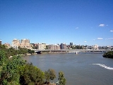
The Brisbane River is the longest river in south east
Queensland
, Australia
, and flows through the city of Brisbane
, before emptying into Moreton Bay
. John Oxley was the first European to explore the river who named it after the Governor of New South Wales
, Thomas Brisbane
in 1823. The penal colony of Moreton Bay later adopted the same name.
Early travellers along the waterway admired the natural beauty, abundant fish and rich vegetation alongs its banks. From 1862 the Brisbane River has been dredged for navigation purposes. The river served as an important carriageway between Brisbane and Ipswich
before a railway linking the towns was built in 1875. By the late 1920s, water quality in the river was significantly deteriorated. The river contains excess nutrients, hydrocarbons, pesticides, bacteria and is murky.
The river travels 344 km from Mount Stanley. The river is dammed by the Wivenhoe Dam
, forming Lake Wivenhoe, the main water supply for Brisbane. The waterway is a habitat for the rare Queensland lungfish
, Brisbane River cod
and bull shark
s. The largest ship built on the river was the Robert Miller. The 66,000 tonne vessel became un-moored in the 1974 Brisbane flood. This flood while not the highest experienced along the river since European settlement it was the most damaging. Major floods also occurred in January 2011 and multiple times during 1893.
Extensive port facilities have been constructed on Fisherman's Island, now known as the Port of Brisbane
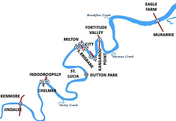
. There are 16 major bridges which cross the river. The Clem Jones Tunnel, opened in 2010, is the river's first underground crossing for road transport. The CityCat ferry service collects and delivers passengers along the inner-city reaches of the river.
 Brisbane River's source is located in the Brisbane Range, east of Kingaroy
. It then makes its way south, past Mount Stanley, and townships including Moore
and Toogoolawah
before being joined by the Stanley River
, just south of Somerset Dam
.
The river runs from there into Lake Wivenhoe
, created by the Wivenhoe Dam. Beyond the dam, the river meanders eastward, meeting the Bremer River near Ipswich
, then making its way through Brisbane's western suburbs, including Jindalee
, Indooroopilly
and Toowong
. The river is travelled upon by CityCats and other ferries in Brisbane
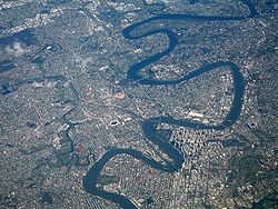
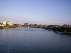
, winding its way through the city centre.
Water from the highest point in the catchment has fallen from Mount Langley in the Conondale Range
, 868 m above sea level. The Brisbane River then flows past wharves including Pinkenba Wharf
and Portside Wharf
, past Bulwer Island
and Luggage Point through the Port of Brisbane
and into southern Bramble Bay
an embayment of Moreton Bay
.
, are the Kangaroo Point Cliffs
. The Kangaroo Point Cliffs were created by a quarrying operation that, according to Allan Cunninghams' Field Book, was underway prior to 1829 when he observed a "stone wharf presumably used for landing the blocks of stone ferried across the river for the construction of buildings in the settlement". This was in the vicinity of Edward Street
ferry terminal. The volcanic rock
Ignimbrite
which formed the cliffs was deposited in the Triassic
period about 220 million years ago. They currently form the banks of the Brisbane River.
On the southside Bulimba Creek
, Norman Creek
, Oxley Creek
, Bremer River and Lockyer Creek
waterways enter the Brisbane River.
The following smaller creeks also flow into the river; Cressbrook Creek, Cooyar Creek, Cubberla Creek, Wolston Creek, Woogaroo Creek, Goodna Creek, Six Mile Creek, Bundamba Creek, Pullen Pullen Creek and Kholo Creek.
 Before European settlement, the Brisbane River was spiritually important and a vital food source for the Aboriginal people of the Turrbal
nation, primarily through fishing in the tidal sections downstream, with fishing and firestick farming in the upper reaches where there was freshwater, depending on the season. The language group common to most of the area was the Yugarabul language group.
Four European navigators, namely Captain Cook, Matthew Flinders
, John Bingle and William Edwardson, all visited Moreton Bay but failed to discover the river. The exploration by Flinders took place during his expedition from Port Jackson
north to Hervey Bay in 1799. He spent a total of 15 days in the area, touching down at Woody Point and several other spots, but failed to discover the mouth of the river although there were suspicions of its existence. This is consistent with accounts of many other rivers along the east coast of Australia
, which could not be found by seaward exploration but were discovered by inland travellers.
On 21 March 1823, four ticket-of-leave convicts sailing south from Sydney on a timber getting mission to Illawarra, Thomas Pamphlett
, John Finnegan
, Richard Parsons
and John Thompson
were blown north by a storm. They went 21 days without water, continuing north in the belief they had been blown south, during which time Thompson died. They landed on Moreton Island
on 16 April and made it to the mainland on the south of the Brisbane River. They immediately began trekking north in order to return to Sydney, still believing themselves to be somewhere south of Jervis Bay. Subsequently they became the first known Europeans to discover the river, stumbling across it somewhere near the entrance. They walked upstream along its banks for nearly a month before making their first crossing at 'Canoe Reach', the junction of Oxley Creek. It was here they stole a small canoe left by the Australian Aborigines
of the region.
John Oxley
was Surveyor General of New South Wales
when, in the same year and under orders from Governor Brisbane, he sailed into Moreton Bay
looking for a suitable new site for a convict settlement to be established. An entry in Oxley's diary on 19 November 1823 describes his surprise meeting with one of the shipwrecked men:
By that time Pamplett and Finnegan were living with natives near Bribie Island. Parsons, who had continued to travel north in search of Sydney, was never heard of again.
On the 2 December 1823, Oxley and Stirling, with Finnegan as a somewhat reluctant guide, entered the river and sailed upstream as far as present-day Goodna
. Oxley noted the abundant fish
and tall pine trees. Early European explorers marvelled at the sheer natural beauty they witnessed while travelling up the lower reaches.
Reports by early European explorers such as Allan Cunningham
and Oxley indicate rainforest once fringed the Brisbane River and its major tributaries, especially on the broader floodplains such as St Lucia
and Seventeen Mile Rocks
. The coastal lowlands were extensively vegetated with Melaleuca
woodlands in low lying, poorly drained coastal areas. When first described by Europeans, the lower reaches of the Brisbane River were fringed by a mosaic of open forest, closed forest and rainforest.
In the same year of 1823, the river was named after Sir Thomas Brisbane
, the then Governor of New South Wales
. Upon the establishment of a local settlement in 1824, other explorers such as Allan Cunningham, Patrick Logan
and Major Edmund Lockyer
made expeditions and surveys further upstream, and, in 1825, the Moreton Bay penal colony at Redcliffe
relocated to North Quay
.
The first small private wharves were built on the river in about 1848. and the once popular, shark-proof river baths were first built in 1857 at Kangaroo Point.
From 1862 the Brisbane River has been dredged for navigation purposes. Throughout much of the 20th century large quantities of sand
and gravel
were extracted from the estuary of the river. Since the rate of materials being deposited is not as high as that which was removed, the river has acted as a subaqueous mine
.
In 1866 there was a breakwater
built at the junction of the Bremer and Brisbane rivers that was designed to stop shingle from blocking the access to the Bremer's boat channel. The first pile light
using kerosene
was built in 1882. The steel
framed light also served as an early port signal station.
 By 1928, due to the early settlement of Brisbane, the water quality had deteriorated to the point where several public baths had to cease sourcing water from the river. yet even up to the 1930s, the water was said to be very clear, with reports of people seeing the river bed 5 or 6 m below the surface. Swimming was once popular at Oxley Point under the Walter Taylor Bridge. In the middle tidal reaches in more recent times, visibility has been about 0.2m. As Brisbane grew, the condition of the river worsened until at its worst it was no more than an open sewer and waste dump. The banks were cleared of timber and introduced animals and plants rapidly changed the river's ecology to its detriment.
On the 25 March 1941, a USA goodwill flotilla
arrived in the city docking at wharves along the River. The largest ship built on the river was the Robert Miller. Construction was near complete when the 66,000 tonne vessel became un-moored in the 1974 Brisbane flood
. In 1977, Queen Elizabeth II switched on a floating fountain positioned in front of the proposed Queensland Cultural Centre
. The jets pushed the floodlit river water up to 75 m in the air. 1987 was proclaimed the "Year of the River" by the Lord Mayor of Brisbane at the time, Sallyanne Atkinson
.
on the upper reaches of the River.
Past floods have resulted in both deepening and reduction in river depth, creation of new sand banks and shoal
s as well as increased transport of suspended sediment from upstream. Before the invention of modern dredging techniques the sediment
deposited by flooding created hazard
s to ships navigating the river. Even medium sized vessels no longer travel up the Brisbane River beyond the city reach, and dredging of the upper reaches has ceased, allowing the river to recover substantially from the fine silt dislodged by gravel and sand extraction.
Significant floods have occurred several times since the European settlement of Brisbane. The most significant of these events was the 1974 Brisbane Flood
. Notable instances of flooding include:
Flooding along the Brisbane River has the potential to be devastating as documented in 1974 and 2011. For much of the river's length its banks are relatively high, but topped by a broad plain. The river's sinuous course means that flood waters from upstream cannot be quickly discharged into Moreton Bay. Thus higher than normal flows cause river levels to rise rapidly and once the top of the banks are breached the floodwaters can spread over wide areas of the city.
to and from Brisbane. The river had served as an important carriageway between Brisbane and Ipswich before a railway linking the towns was built in 1875. By early 1825 buoy
s were being laid along the South Passage
and shortly after that the first pilots were commissioned to guide ships entering from Moreton Bay and another service for those travelling upstream. Flying boats used the waters of the river in Pinkenba
, to take-off for domestic and international destinations in the 1930s.
The river depth was progressively increased and narrow points widened to allow larger vessels into the river and further upstream. For navigation and safety reasons the Seventeen Mile Rocks were completely removed in 1965 after numerous partially successful attempts in the past. The northern river bank at the mouth of the river has undergone reclamation projects over the years, especially in the suburbs of Hamilton
and Pinkenba
. More recently, extensive port facilities have been constructed on Fisherman's Island
which has also seen significant land reclamation
into the bay.
Early rivers crossings were made using small oared boat ferries
, beginning in 1843, followed by steam ferries. In 1865 the first Victoria Bridge
, later destroyed in a flood, was built across the river. Professor Hawken
of the University of Queensland
undertook a study in 1914 to identify the future crossing points for the river.
Historically, the Brisbane River contained upstream bars and shallows and had a natural tidal limit of only 16 km. The current tidal limit now extends 85 km upstream due to continual channel dredging.
and the Brisbane Valley Highway
. The Clem Jones Tunnel, opened in 2010, is the river's first underground crossing for road transport.
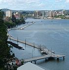 The Brisbane City Council has been developing a network of riverwalk pavements along the banks of the Brisbane River. Jim Soorley
, a former mayor of Brisbane, encouraged serious investment into the quality and capacity of the Brisbane riverwalk.
An interesting section is the floating walkway between the Story Bridge
and Merthyr Street New Farm
. Brisbane City planners require many developers of formerly private riverfront blocks to create new sections of the Brisbane Riverwalk that are accessible to the public.
During the flood in January 2011
, the Lord Mayor of Brisbane, Campbell Newman
authorised the destruction of the Brisbane Riverwalk to prevent it floating away and becoming a hazard downstream. The proposed demolition of the Riverwalk was later cancelled.
Early in the morning of 13 January 2011 a several hundred metre long section of the Riverwalk broke away from the main structure and floated downstream. Queensland Police temporarily closed the Sir Leo Hielscher Bridges (commonly known as the Gateway Bridge) several times as there were fears that sections of Riverwalk could collide with and damage the bridge. The largest part of the floating boardwalk was safely guided under the bridge by a tugboat
and past other infrastructure
before being safely secured. Other tugs and Water Police guided other Riverwalk sections under the bridge.
. The plant was originally imported from South America.
Environmentally, the river is in a poor condition and has been so for many years. In 2000, the Brisbane River estuary did not meet the national guidelines for environmental standards. The lower reaches received a very poor rating in the 2008 Healthy Waterways report, an annual assessment of river water quality. The major causes of pollution
are excess nutrients, hydrocarbons, pesticides and bacteria
which become concentrated in the river and its sediment
after flowing off surrounding lands. The river is also considered too murky and it is not recommended to swim in its waters.
 Historically, the river was actively dredged by Boral
Sands Inc, ostensibly to make the river navigable. The constant extraction of river bed material by dredges has had considerable effect on the river. These impacts include increased turbidity, bed and bank erosion and changes in tidal hydraulics. The tidal nature of the river and the generally muddy nature of the sands removed by dredging created a woefully sludgy clayey sediment load in the river which did not clear.
The efficacy of dredging the river upstream of the city reach to make it "navigable" was always in doubt, and the effect of the artificial sediment load in Moreton Bay grew to concern environmentalists worried that sediment was choking sea grass paddocks which were grazing territory for dugong
. In a meeting concerning the matter in October 1996, including two State Government Ministers and three Mayors, an agreement to cease the dredging of sand and gravel from the river by September 30, 1997 was formed. Boral Resources Pty. Ltd. resisted the agreement, but ultimately all dredging was stopped by the agreed date.
s exist; these include areas around drainage culverts, in Breakfast Creek, New Farm
, a small preserve at the city bend, near the Queensland University of Technology
and around the shipping terminals at the river's terminus into Moreton Bay. These mangroves have recently become classified as protected nature reserve
s. The noxious water hyacinth weed is still growing in stretches between Fernvale
and the Mount Crosby Weir
but only poses a minimal risk to drinking water supplies.
.
, which was similar to Murray cod
and closely related to eastern freshwater cod
and Mary River cod
. Unfortunately this unique native fish became extinct somewhere between the 1930s and 1950s due to habitat degradation and overfishing. The river has been restocked with cod from the Mary River.
. There have been three recorded shark attack deaths in the river (1880, 1901 and 1921), and one other unconfirmed death of an Aboriginal boy in 1862. The shark can be aggressive, grow up to 3 m in length and is unusual for a shark species because it can inhabit water containing less than 50% seawater.
, Riverfire
and the Brisbane River Classic
fishing competition. Many schools and clubs use the river to conduct rowing
regattas on Milton Reach. Sailing regattas are also held on this reach as well as the Hamilton reach.
South East Queensland
South East Queensland is a region of the state of Queensland in Australia, which contains approximately two-thirds of the state population...
Queensland
Queensland
Queensland is a state of Australia, occupying the north-eastern section of the mainland continent. It is bordered by the Northern Territory, South Australia and New South Wales to the west, south-west and south respectively. To the east, Queensland is bordered by the Coral Sea and Pacific Ocean...
, Australia
Australia
Australia , officially the Commonwealth of Australia, is a country in the Southern Hemisphere comprising the mainland of the Australian continent, the island of Tasmania, and numerous smaller islands in the Indian and Pacific Oceans. It is the world's sixth-largest country by total area...
, and flows through the city of Brisbane
Brisbane
Brisbane is the capital and most populous city in the Australian state of Queensland and the third most populous city in Australia. Brisbane's metropolitan area has a population of over 2 million, and the South East Queensland urban conurbation, centred around Brisbane, encompasses a population of...
, before emptying into Moreton Bay
Moreton Bay
Moreton Bay is a bay on the eastern coast of Australia 45 km from Brisbane, Queensland. It is one of Queensland's most important coastal resources...
. John Oxley was the first European to explore the river who named it after the Governor of New South Wales
Governors of New South Wales
The Governor of New South Wales is the state viceregal representative of the Australian monarch, Queen Elizabeth II, who is equally shared with 15 other sovereign nations in a form of personal union, as well as with the eleven other jurisdictions of Australia, and resides predominantly in her...
, Thomas Brisbane
Thomas Brisbane
Major-General Sir Thomas Makdougall Brisbane, 1st Baronet GCH, GCB, FRS, FRSE was a British soldier, colonial Governor and astronomer.-Early life:...
in 1823. The penal colony of Moreton Bay later adopted the same name.
Early travellers along the waterway admired the natural beauty, abundant fish and rich vegetation alongs its banks. From 1862 the Brisbane River has been dredged for navigation purposes. The river served as an important carriageway between Brisbane and Ipswich
Ipswich, Queensland
Ipswich is a city in South-East Queensland, Australia. Situated along the Bremer River Valley approximately 40 kilometres away from the state's capital Brisbane. The suburb by the same name forms the city's Central Business District and administrative centre...
before a railway linking the towns was built in 1875. By the late 1920s, water quality in the river was significantly deteriorated. The river contains excess nutrients, hydrocarbons, pesticides, bacteria and is murky.
The river travels 344 km from Mount Stanley. The river is dammed by the Wivenhoe Dam
Wivenhoe Dam
Wivenhoe Dam is a dam across the Brisbane River a little way upstream from Locker Creek. The dam creates the artificial Lake Wivenhoe. The dam wall is located about by road from the centre of Brisbane, Queensland, Australia....
, forming Lake Wivenhoe, the main water supply for Brisbane. The waterway is a habitat for the rare Queensland lungfish
Queensland Lungfish
The Queensland lungfish, Neoceratodus forsteri is the sole surviving member of the family Ceratodontidae and order Ceratodontiformes. It is one of only six extant lungfish species in the world...
, Brisbane River cod
Brisbane River cod
The Brisbane River cod was a unique form of Maccullochella cod that occurred naturally in the Brisbane River system, an east coast river system in south east Queensland, Australia...
and bull shark
Bull shark
The bull shark, Carcharhinus leucas, also known as Zambezi shark or unofficially known as Zambi in Africa and Nicaragua shark in Nicaragua, is a shark common worldwide in warm, shallow waters along coasts and in rivers...
s. The largest ship built on the river was the Robert Miller. The 66,000 tonne vessel became un-moored in the 1974 Brisbane flood. This flood while not the highest experienced along the river since European settlement it was the most damaging. Major floods also occurred in January 2011 and multiple times during 1893.
Extensive port facilities have been constructed on Fisherman's Island, now known as the Port of Brisbane
Port of Brisbane
Port of Brisbane is the shipping port of Brisbane, on the east coast of Australia. It is located in the lower reaches of the Brisbane River on reclaimed land that was once called Fisherman Islands at the mouth of the river. It currently is the third busiest port in Australia and the nation's...
. There are 16 major bridges which cross the river. The Clem Jones Tunnel, opened in 2010, is the river's first underground crossing for road transport. The CityCat ferry service collects and delivers passengers along the inner-city reaches of the river.
Course
Kingaroy, Queensland
Kingaroy is an agricultural town in Queensland, Australia, approximately or about 2½ hours drive north-west of the state capital Brisbane. The town is situated on the junction of the D'Aguilar and the Bunya Highways...
. It then makes its way south, past Mount Stanley, and townships including Moore
Moore, Queensland
Moore is a town in South East Queensland, north west of Brisbane. It is situated at the base of the Balfour Range on the D'Aguilar Highway, between Esk in the Brisbane River valley and Yarraman in the South Burnett....
and Toogoolawah
Toogoolawah, Queensland
Toogoolawah is a small town in South East Queensland, Australia. Toogoolawah is a centre for gliding and parachuting and in the past the centre of a dairying industry. Cressbrook Creek, a tributary of the Brisbane River, passes through the town as does the Brisbane Valley Highway...
before being joined by the Stanley River
Stanley River (Queensland)
The Stanley River in Queensland is the main tributary of the Brisbane River. The Stanley River valley extends roughly 35 km westwards from the area south of Maleny to Kilcoy before veering southwards....
, just south of Somerset Dam
Lake Somerset
Lake Somerset is an artificial lake created by the Somerset Dam on the Stanley River in South East Queensland. The dam was completed in 1953 providing flood mitigation and water storage for the cities of Brisbane and Ipswich and is the site of a small 4 MW hydroelectric power station.At full...
.
The river runs from there into Lake Wivenhoe
Wivenhoe Dam
Wivenhoe Dam is a dam across the Brisbane River a little way upstream from Locker Creek. The dam creates the artificial Lake Wivenhoe. The dam wall is located about by road from the centre of Brisbane, Queensland, Australia....
, created by the Wivenhoe Dam. Beyond the dam, the river meanders eastward, meeting the Bremer River near Ipswich
Ipswich, Queensland
Ipswich is a city in South-East Queensland, Australia. Situated along the Bremer River Valley approximately 40 kilometres away from the state's capital Brisbane. The suburb by the same name forms the city's Central Business District and administrative centre...
, then making its way through Brisbane's western suburbs, including Jindalee
Jindalee, Queensland
Jindalee is an outer suburb of Brisbane, Australia located south-west of the Brisbane CBD, and is a part of the Centenary suburbs. It is bordered by the Brisbane River to the north. The Aboriginal meaning for Jindalee is "bare hills"...
, Indooroopilly
Indooroopilly, Queensland
Indooroopilly is a suburb of Brisbane, Australia which is located 7 km west of the Brisbane central business district.- Name derivation and history :...
and Toowong
Toowong, Queensland
Toowong is an inner suburb of Brisbane, Australia which is located 5 km west of the Brisbane CBD. At the centre of Toowong is a commercial precinct including Toowong Village and several office buildings...
. The river is travelled upon by CityCats and other ferries in Brisbane
Brisbane Ferries
Ferry transport in Queensland provides both historical and current information relating to scheduled public passenger ferry services in Queensland...
, winding its way through the city centre.
Water from the highest point in the catchment has fallen from Mount Langley in the Conondale Range
Conondale Range
The Conondale Range is a mountain range in Queensland, located between Maleny, Kenilworth, Kilcoy and Jimna. The range is the most westerly part of the Sunshine Coast hinterland and part of the Great Dividing Range. The highest point on the range is Mount Langley reaching 868 m above sea level...
, 868 m above sea level. The Brisbane River then flows past wharves including Pinkenba Wharf
Pinkenba Wharf
Pinkenba Wharf is an Australian wharf, located in within the Port of Brisbane, Queensland, Australia. The larger ocean going cruise liners that visit the port currently dock at the Pinkenba Wharf, located on the north side of the Brisbane River, north of the Gateway Bridge, due to height...
and Portside Wharf
Portside Wharf
Portside Wharf is the residential and retail development at Hamilton, Brisbane, Queensland, Australia. The Brisbane Cruise Terminal which is also part of the development was opened on 29 August 2006....
, past Bulwer Island
Bulwer Island, Queensland
Bulwer Island is a reclaimed tidal mangrove island at the mouth of the Brisbane River in the city of Brisbane, Queensland, Australia. It is named for Sir Edward Bulwer-Lytton, the British Colonial Secretary who separated Queensland from New South Wales in 1859 and made Sir George Bowen its first...
and Luggage Point through the Port of Brisbane
Port of Brisbane
Port of Brisbane is the shipping port of Brisbane, on the east coast of Australia. It is located in the lower reaches of the Brisbane River on reclaimed land that was once called Fisherman Islands at the mouth of the river. It currently is the third busiest port in Australia and the nation's...
and into southern Bramble Bay
Bramble Bay
Bramble Bay is an embayment of Moreton Bay in South East Queensland, Australia. The Brisway map reference is 12 H5, or see page 91 G19 in Refidex.The Houghton Highway and the Hornibrook Bridge span Bramble Bay, connecting Redcliffe with Brisbane...
an embayment of Moreton Bay
Moreton Bay
Moreton Bay is a bay on the eastern coast of Australia 45 km from Brisbane, Queensland. It is one of Queensland's most important coastal resources...
.
Kangaroo Point Cliffs
On the southern side of the river, opposite Gardens PointGardens Point, Brisbane
Gardens Point is a point on the northern bank of the Brisbane River. The Brisbane CBD extends northwards of the point.Located here are Queensland's Parliament House, the Gardens Point campus of the Queensland University of Technology, the Brisbane City Botanic Gardens and Queensland's Old...
, are the Kangaroo Point Cliffs
Kangaroo Point Cliffs
The Kangaroo Point Cliffs are located at Kangaroo Point just across the Brisbane River from the Brisbane CBD in Queensland, Australia. A popular recreation spot, they are conveniently close to the city and the South Bank Parklands...
. The Kangaroo Point Cliffs were created by a quarrying operation that, according to Allan Cunninghams' Field Book, was underway prior to 1829 when he observed a "stone wharf presumably used for landing the blocks of stone ferried across the river for the construction of buildings in the settlement". This was in the vicinity of Edward Street
Edward Street, Brisbane
Edward Street is a busy thoroughfare in the Brisbane central business district, Queensland, Australia. It is a one way street located between Albert Street and Creek Street, and runs from Upper Edward Street to Alice Street....
ferry terminal. The volcanic rock
Volcanic rock
Volcanic rock is a rock formed from magma erupted from a volcano. In other words, it is an igneous rock of volcanic origin...
Ignimbrite
Ignimbrite
An ignimbrite is the deposit of a pyroclastic density current, or pyroclastic flow, a hot suspension of particles and gases that flows rapidly from a volcano, driven by a greater density than the surrounding atmosphere....
which formed the cliffs was deposited in the Triassic
Triassic
The Triassic is a geologic period and system that extends from about 250 to 200 Mya . As the first period of the Mesozoic Era, the Triassic follows the Permian and is followed by the Jurassic. Both the start and end of the Triassic are marked by major extinction events...
period about 220 million years ago. They currently form the banks of the Brisbane River.
Tributaries
The following major tributaries flow into the Brisbane River from the north; Breakfast Creek, Moggill Creek and the Stanley RiverOn the southside Bulimba Creek
Bulimba Creek, Queensland
The Bulimba Creek catchment has it sources in the marshy parts of the suburbs of Runcorn and Kuraby in the south of Brisbane. It then flows in a northerly direction through the suburbs of Mansfield, Mackenzie, Carindale, Murarrie and Lytton, before meeting the Brisbane River along the Lytton Reach...
, Norman Creek
Norman Creek
Norman Creek is a small tributary of the Brisbane River. The headwaters of the creek are located on the northern slopes of Toohey Mountain and Mount Gravatt in southern Brisbane.Edmund Lockyer named the waterway Norman Creek in 1825....
, Oxley Creek
Oxley Creek, Queensland
Oxley Creek is situated in south east Queensland, Australia and is one of the major tributaries of the Brisbane River with an estimated 260 square kilometres in area...
, Bremer River and Lockyer Creek
Lockyer Creek, Queensland
Lockyer Creek is a major drainage system in the Lockyer Valley of South East Queensland that flows into the Brisbane River a few kilometres north-north/east of Lowood, and downstream from the Wivenhoe Dam...
waterways enter the Brisbane River.
The following smaller creeks also flow into the river; Cressbrook Creek, Cooyar Creek, Cubberla Creek, Wolston Creek, Woogaroo Creek, Goodna Creek, Six Mile Creek, Bundamba Creek, Pullen Pullen Creek and Kholo Creek.
History
Turrbal
The Turrbal are a tribe of Australian Aboriginal people who inhabited the region around the city of Brisbane before European settlement of Australia. Tom Petrie, an early pioneer of Brisbane, shows the kind and trustworthy nature of the Turrbal people. He demonstrates how they were forgiving, even...
nation, primarily through fishing in the tidal sections downstream, with fishing and firestick farming in the upper reaches where there was freshwater, depending on the season. The language group common to most of the area was the Yugarabul language group.
Four European navigators, namely Captain Cook, Matthew Flinders
Matthew Flinders
Captain Matthew Flinders RN was one of the most successful navigators and cartographers of his age. In a career that spanned just over twenty years, he sailed with Captain William Bligh, circumnavigated Australia and encouraged the use of that name for the continent, which had previously been...
, John Bingle and William Edwardson, all visited Moreton Bay but failed to discover the river. The exploration by Flinders took place during his expedition from Port Jackson
Port Jackson
Port Jackson, containing Sydney Harbour, is the natural harbour of Sydney, Australia. It is known for its beauty, and in particular, as the location of the Sydney Opera House and Sydney Harbour Bridge...
north to Hervey Bay in 1799. He spent a total of 15 days in the area, touching down at Woody Point and several other spots, but failed to discover the mouth of the river although there were suspicions of its existence. This is consistent with accounts of many other rivers along the east coast of Australia
Australia
Australia , officially the Commonwealth of Australia, is a country in the Southern Hemisphere comprising the mainland of the Australian continent, the island of Tasmania, and numerous smaller islands in the Indian and Pacific Oceans. It is the world's sixth-largest country by total area...
, which could not be found by seaward exploration but were discovered by inland travellers.
On 21 March 1823, four ticket-of-leave convicts sailing south from Sydney on a timber getting mission to Illawarra, Thomas Pamphlett
Thomas Pamphlett
Thomas Pamphlett , sometimes Pamphlet, also known as James Groom, was a convict in colonial Australia. He is best known for his time as a castaway in the Moreton Bay area, halfway up the eastern coast of Australia, in 1823. He was marooned with two others, Richard Parsons and John Finnegan, until...
, John Finnegan
John Finnegan
John Finnegan, a convict of the colony of New South Wales , was one of four men who set off on a timber getting mission from Sydney bound for Illawarra in 1823...
, Richard Parsons
Richard Parsons (convict)
Richard Parsons, a convict of the colony of New South Wales , was one of four men who set off on a timber getting mission from Sydney bound for Illawarra in 1823...
and John Thompson
John Thompson (convict)
John Thompson, a convict of the colony of New South Wales , was one of four men who set off on a timber getting mission from Sydney bound for Illawarra in 1823...
were blown north by a storm. They went 21 days without water, continuing north in the belief they had been blown south, during which time Thompson died. They landed on Moreton Island
Moreton Island
Moreton Island is a large sand island on the eastern side of Moreton Bay, on the coast of south-east Queensland, Australia. Moreton Island lies 58 kilometres northeast of the Queensland capital, Brisbane. The island is 95% National Park and a popular destination for four wheel driving, camping,...
on 16 April and made it to the mainland on the south of the Brisbane River. They immediately began trekking north in order to return to Sydney, still believing themselves to be somewhere south of Jervis Bay. Subsequently they became the first known Europeans to discover the river, stumbling across it somewhere near the entrance. They walked upstream along its banks for nearly a month before making their first crossing at 'Canoe Reach', the junction of Oxley Creek. It was here they stole a small canoe left by the Australian Aborigines
Australian Aborigines
Australian Aborigines , also called Aboriginal Australians, from the latin ab originem , are people who are indigenous to most of the Australian continentthat is, to mainland Australia and the island of Tasmania...
of the region.
John Oxley
John Oxley
John Joseph William Molesworth Oxley was an explorer and surveyor of Australia in the early period of English colonisation.October 1802 he was engaged in coastal survey work including an expedition to Western Port in 1804-05...
was Surveyor General of New South Wales
New South Wales
New South Wales is a state of :Australia, located in the east of the country. It is bordered by Queensland, Victoria and South Australia to the north, south and west respectively. To the east, the state is bordered by the Tasman Sea, which forms part of the Pacific Ocean. New South Wales...
when, in the same year and under orders from Governor Brisbane, he sailed into Moreton Bay
Moreton Bay
Moreton Bay is a bay on the eastern coast of Australia 45 km from Brisbane, Queensland. It is one of Queensland's most important coastal resources...
looking for a suitable new site for a convict settlement to be established. An entry in Oxley's diary on 19 November 1823 describes his surprise meeting with one of the shipwrecked men:
- "We rounded the Point Skirmish about 5 o'clock and observed a number of natives running along the beach towards the vessel, the foremost much lighter in colour than the rest. We were to the last degree astonished when he came abreast the vessel to hear him hail us in good English."
By that time Pamplett and Finnegan were living with natives near Bribie Island. Parsons, who had continued to travel north in search of Sydney, was never heard of again.
On the 2 December 1823, Oxley and Stirling, with Finnegan as a somewhat reluctant guide, entered the river and sailed upstream as far as present-day Goodna
Goodna, Queensland
Goodna is a suburb on the eastern edge of the City of Ipswich in Queensland, Australia.It is bounded to the north by the Brisbane River. Founded in 1856 when the area was still part of New South Wales, it celebrated its 150 year anniversary in 2006. Its beginnings can be traced back further to...
. Oxley noted the abundant fish
Fish
Fish are a paraphyletic group of organisms that consist of all gill-bearing aquatic vertebrate animals that lack limbs with digits. Included in this definition are the living hagfish, lampreys, and cartilaginous and bony fish, as well as various extinct related groups...
and tall pine trees. Early European explorers marvelled at the sheer natural beauty they witnessed while travelling up the lower reaches.
Reports by early European explorers such as Allan Cunningham
Allan Cunningham (botanist)
Allan Cunningham was an English botanist and explorer, primarily known for his travels in New South Wales to collect plants.- Early life :...
and Oxley indicate rainforest once fringed the Brisbane River and its major tributaries, especially on the broader floodplains such as St Lucia
St Lucia, Queensland
St Lucia is an inner suburb of Brisbane, Australia located 4 km south-west of the Brisbane CBD. The suburb is bordered on three sides by the Brisbane River and is dominated by the main campus of the University of Queensland.-History:...
and Seventeen Mile Rocks
Seventeen Mile Rocks, Queensland
Seventeen Mile Rocks is a suburb of Brisbane, Australia located south-west of the Brisbane CBD on the Brisbane River.Seventeen Mile Rocks is named after a collection of rocks that marked a distance of from the mouth of the Brisbane River...
. The coastal lowlands were extensively vegetated with Melaleuca
Melaleuca
Melaleuca is a genus of plants in the myrtle family Myrtaceae known for its natural soothing and cleansing properties. There are well over 200 recognised species, most of which are endemic to Australia...
woodlands in low lying, poorly drained coastal areas. When first described by Europeans, the lower reaches of the Brisbane River were fringed by a mosaic of open forest, closed forest and rainforest.
In the same year of 1823, the river was named after Sir Thomas Brisbane
Thomas Brisbane
Major-General Sir Thomas Makdougall Brisbane, 1st Baronet GCH, GCB, FRS, FRSE was a British soldier, colonial Governor and astronomer.-Early life:...
, the then Governor of New South Wales
Governors of New South Wales
The Governor of New South Wales is the state viceregal representative of the Australian monarch, Queen Elizabeth II, who is equally shared with 15 other sovereign nations in a form of personal union, as well as with the eleven other jurisdictions of Australia, and resides predominantly in her...
. Upon the establishment of a local settlement in 1824, other explorers such as Allan Cunningham, Patrick Logan
Patrick Logan
Captain Patrick Logan was the commandant of the Moreton Bay penal colony from 1826 until his death in 1830. He is thought to have been killed by Aboriginal Australians who objected to him entering their lands...
and Major Edmund Lockyer
Edmund Lockyer
Edmund Lockyer, – 10 June 1860) was a British soldier and explorer of Australia.Born in Plymouth, Devon, Lockyer was son of Thomas Lockyer, a sailmaker, and his wife Ann, née Grose. Lockyer began his army career as an ensign in the 19th Regiment in June 1803, was promoted lieutenant in early 1805...
made expeditions and surveys further upstream, and, in 1825, the Moreton Bay penal colony at Redcliffe
Redcliffe, Queensland
Redcliffe is a residential suburb of the Moreton Bay Region in the north-east of the Redcliffe peninsula, approximately north-northeast of Brisbane, the state capital of Queensland, Australia...
relocated to North Quay
North Quay, Brisbane
North Quay is a location in the Brisbane central business district and the name of street in the same area, running along the Brisbane River from an intersection near Makerston Street to the top of the Queen Street.-Location:...
.
The first small private wharves were built on the river in about 1848. and the once popular, shark-proof river baths were first built in 1857 at Kangaroo Point.
From 1862 the Brisbane River has been dredged for navigation purposes. Throughout much of the 20th century large quantities of sand
Sand
Sand is a naturally occurring granular material composed of finely divided rock and mineral particles.The composition of sand is highly variable, depending on the local rock sources and conditions, but the most common constituent of sand in inland continental settings and non-tropical coastal...
and gravel
Gravel
Gravel is composed of unconsolidated rock fragments that have a general particle size range and include size classes from granule- to boulder-sized fragments. Gravel can be sub-categorized into granule and cobble...
were extracted from the estuary of the river. Since the rate of materials being deposited is not as high as that which was removed, the river has acted as a subaqueous mine
Mining
Mining is the extraction of valuable minerals or other geological materials from the earth, from an ore body, vein or seam. The term also includes the removal of soil. Materials recovered by mining include base metals, precious metals, iron, uranium, coal, diamonds, limestone, oil shale, rock...
.
In 1866 there was a breakwater
Breakwater (structure)
Breakwaters are structures constructed on coasts as part of coastal defence or to protect an anchorage from the effects of weather and longshore drift.-Purposes of breakwaters:...
built at the junction of the Bremer and Brisbane rivers that was designed to stop shingle from blocking the access to the Bremer's boat channel. The first pile light
Pile lighthouse
A pile lighthouse is a type of lighthouse used primarily in Florida, including on open reefs adjacent to the Florida Keys. Another place in which pile lights are prevalent is Australia....
using kerosene
Kerosene
Kerosene, sometimes spelled kerosine in scientific and industrial usage, also known as paraffin or paraffin oil in the United Kingdom, Hong Kong, Ireland and South Africa, is a combustible hydrocarbon liquid. The name is derived from Greek keros...
was built in 1882. The steel
Steel
Steel is an alloy that consists mostly of iron and has a carbon content between 0.2% and 2.1% by weight, depending on the grade. Carbon is the most common alloying material for iron, but various other alloying elements are used, such as manganese, chromium, vanadium, and tungsten...
framed light also served as an early port signal station.
20th century
On the 25 March 1941, a USA goodwill flotilla
Flotilla
A flotilla , or naval flotilla, is a formation of small warships that may be part of a larger fleet. A flotilla is usually composed of a homogeneous group of the same class of warship, such as frigates, destroyers, torpedo boats, submarines, gunboats, or minesweepers...
arrived in the city docking at wharves along the River. The largest ship built on the river was the Robert Miller. Construction was near complete when the 66,000 tonne vessel became un-moored in the 1974 Brisbane flood
1974 Brisbane flood
The 1974 Brisbane flood occurred in January 1974 in Brisbane, Queensland, Australia, when waterways in the city experienced significant flooding...
. In 1977, Queen Elizabeth II switched on a floating fountain positioned in front of the proposed Queensland Cultural Centre
Queensland Cultural Centre
The Queensland Cultural Centre is a multi-venue centre located at South Bank, Brisbane, capital city of Queensland. It consists of the Queensland Performing Arts Centre , the Queensland Museum, the State Library of Queensland , the Queensland Art Gallery and the Queensland Gallery of Modern Art...
. The jets pushed the floodlit river water up to 75 m in the air. 1987 was proclaimed the "Year of the River" by the Lord Mayor of Brisbane at the time, Sallyanne Atkinson
Sallyanne Atkinson
Sallyanne Atkinson AO is an Australian politician, former Lord Mayor of Brisbane and former chair of ABC Learning, a bankrupted Australian childcare operator.She is Special Representative for the Queensland Government in South-East Asia....
.
Floods
The Brisbane River floods frequently, although the occurrence and magnitude of flooding has diminished following the construction of the Wivenhoe DamWivenhoe Dam
Wivenhoe Dam is a dam across the Brisbane River a little way upstream from Locker Creek. The dam creates the artificial Lake Wivenhoe. The dam wall is located about by road from the centre of Brisbane, Queensland, Australia....
on the upper reaches of the River.
Past floods have resulted in both deepening and reduction in river depth, creation of new sand banks and shoal
Shoal
Shoal, shoals or shoaling may mean:* Shoal, a sandbank or reef creating shallow water, especially where it forms a hazard to shipping* Shoal draught , of a boat with shallow draught which can pass over some shoals: see Draft...
s as well as increased transport of suspended sediment from upstream. Before the invention of modern dredging techniques the sediment
Sediment
Sediment is naturally occurring material that is broken down by processes of weathering and erosion, and is subsequently transported by the action of fluids such as wind, water, or ice, and/or by the force of gravity acting on the particle itself....
deposited by flooding created hazard
Hazard
A hazard is a situation that poses a level of threat to life, health, property, or environment. Most hazards are dormant or potential, with only a theoretical risk of harm; however, once a hazard becomes "active", it can create an emergency situation. A hazard does not exist when it is not...
s to ships navigating the river. Even medium sized vessels no longer travel up the Brisbane River beyond the city reach, and dredging of the upper reaches has ceased, allowing the river to recover substantially from the fine silt dislodged by gravel and sand extraction.
Significant floods have occurred several times since the European settlement of Brisbane. The most significant of these events was the 1974 Brisbane Flood
1974 Brisbane flood
The 1974 Brisbane flood occurred in January 1974 in Brisbane, Queensland, Australia, when waterways in the city experienced significant flooding...
. Notable instances of flooding include:
- 14 January 1841 (Highest flood level to date)
- March 1890
- February 18931893 Brisbane floodThe 1893 Brisbane flood, occasionally referred to as the Great Flood of 1893 or the Black February flood, occurred when the Brisbane River burst its banks on three occasions in February 1893. It is the occurrence of three major floods in the same month that saw the period named "Black February"....
, a sequence of flood peaks over some three weeks saw the highest recorded flood level in the Brisbane central business districtCentral business districtA central business district is the commercial and often geographic heart of a city. In North America this part of a city is commonly referred to as "downtown" or "city center"...
. Seven lives were lost in the Eclipse Colliery at North IpswichNorth Ipswich, QueenslandNorth Ipswich is a suburb of Ipswich, Queensland, Australia. This is the birthplace of Queensland Rail. The original site is now the site of Riverlink shopping centre on The Terrace and the current site is used as a joint facility containing the very popular multi award winning Rail Workshop...
as a direct result of the flooding. Several other lives were lost to drownings. - February 1931
- 27 January 19741974 Brisbane floodThe 1974 Brisbane flood occurred in January 1974 in Brisbane, Queensland, Australia, when waterways in the city experienced significant flooding...
(Largest flood to affect Brisbane City in the 20th Century). - 11 January 2011
Flooding along the Brisbane River has the potential to be devastating as documented in 1974 and 2011. For much of the river's length its banks are relatively high, but topped by a broad plain. The river's sinuous course means that flood waters from upstream cannot be quickly discharged into Moreton Bay. Thus higher than normal flows cause river levels to rise rapidly and once the top of the banks are breached the floodwaters can spread over wide areas of the city.
Navigation
There has been much dredging and widening work done over the years to allow ships to transport cargoCargo
Cargo is goods or produce transported, generally for commercial gain, by ship, aircraft, train, van or truck. In modern times, containers are used in most intermodal long-haul cargo transport.-Marine:...
to and from Brisbane. The river had served as an important carriageway between Brisbane and Ipswich before a railway linking the towns was built in 1875. By early 1825 buoy
Buoy
A buoy is a floating device that can have many different purposes. It can be anchored or allowed to drift. The word, of Old French or Middle Dutch origin, is now most commonly in UK English, although some orthoepists have traditionally prescribed the pronunciation...
s were being laid along the South Passage
South Passage (Queensland)
South Passage is channel between the South Pacific Ocean and Moreton Bay. The other entrances to the bay are the North Passage and Jumpinpin Channel in the south.It was once the main entrance for ships entering the bay...
and shortly after that the first pilots were commissioned to guide ships entering from Moreton Bay and another service for those travelling upstream. Flying boats used the waters of the river in Pinkenba
Pinkenba, Queensland
Pinkenba is the name of a suburb in eastern Brisbane on the northern side of the Brisbane River. Despite being less than 10 kilometres from the Brisbane central business district, it has a largely rural feel to it...
, to take-off for domestic and international destinations in the 1930s.
The river depth was progressively increased and narrow points widened to allow larger vessels into the river and further upstream. For navigation and safety reasons the Seventeen Mile Rocks were completely removed in 1965 after numerous partially successful attempts in the past. The northern river bank at the mouth of the river has undergone reclamation projects over the years, especially in the suburbs of Hamilton
Hamilton, Queensland
Hamilton is an inner northern suburb of Brisbane, Australia, lying on the north bank of the Brisbane River along Bulimba Reach. The area is hilly with views of the Brisbane central business district....
and Pinkenba
Pinkenba, Queensland
Pinkenba is the name of a suburb in eastern Brisbane on the northern side of the Brisbane River. Despite being less than 10 kilometres from the Brisbane central business district, it has a largely rural feel to it...
. More recently, extensive port facilities have been constructed on Fisherman's Island
Port of Brisbane
Port of Brisbane is the shipping port of Brisbane, on the east coast of Australia. It is located in the lower reaches of the Brisbane River on reclaimed land that was once called Fisherman Islands at the mouth of the river. It currently is the third busiest port in Australia and the nation's...
which has also seen significant land reclamation
Land reclamation
Land reclamation, usually known as reclamation, is the process to create new land from sea or riverbeds. The land reclaimed is known as reclamation ground or landfill.- Habitation :...
into the bay.
Early rivers crossings were made using small oared boat ferries
Ferry
A ferry is a form of transportation, usually a boat, but sometimes a ship, used to carry primarily passengers, and sometimes vehicles and cargo as well, across a body of water. Most ferries operate on regular, frequent, return services...
, beginning in 1843, followed by steam ferries. In 1865 the first Victoria Bridge
Victoria Bridge, Brisbane
The Victoria Bridge is a vehicular and pedestrian bridge over the Brisbane River. The current bridge, opened in 1969, is the third permanent crossing erected at this location...
, later destroyed in a flood, was built across the river. Professor Hawken
Roger Hawken
Roger William Hercules Hawken , an Australian engineer, was the first lecturer in Civil Engineering, and then a professor, at the University of Queensland.-Personal life:...
of the University of Queensland
University of Queensland
The University of Queensland, also known as UQ, is a public university located in state of Queensland, Australia. Founded in 1909, it is the oldest and largest university in Queensland and the fifth oldest in the nation...
undertook a study in 1914 to identify the future crossing points for the river.
Historically, the Brisbane River contained upstream bars and shallows and had a natural tidal limit of only 16 km. The current tidal limit now extends 85 km upstream due to continual channel dredging.
Crossings
Currently the Brisbane River is crossed by 16 major bridges(new second Gateway Bridge), including the historic Story Bridge and the tolled Sir Leo Hielscher Bridges. There are two other major bridges upstream west of Brisbane, on the D'Aguilar HighwayD'Aguilar Highway
The D'Aguilar Highway is a two-lane highway linking the Bruce Highway near Caboolture with Kingaroy in the state of Queensland, Australia. Major towns along the route include Woodford, Kilcoy, Yarraman, Nanango and Kingaroy...
and the Brisbane Valley Highway
Brisbane Valley Highway
The Brisbane Valley Highway is a state highway in Queensland. It leaves the Warrego Highway near Ipswich and travels in a northwesterly direction, following the Brisbane River until it reaches the D'Aguilar Highway about south-east of Moore, where it ends...
. The Clem Jones Tunnel, opened in 2010, is the river's first underground crossing for road transport.
Brisbane Riverwalk
Jim Soorley
James Gerard Soorley is a former Australian politician. He served as Australian Labor Party Lord Mayor of Brisbane from 1991 to 2003. Soorley is a former Roman Catholic Priest and continues to be a strong human rights advocate...
, a former mayor of Brisbane, encouraged serious investment into the quality and capacity of the Brisbane riverwalk.
An interesting section is the floating walkway between the Story Bridge
Story Bridge, Brisbane
The Story Bridge is a cantilever bridge spanning the Brisbane River. Part of Bradfield Highway , it connects Fortitude Valley to Kangaroo Point. Before the opening of the Sydney Harbour Bridge in 1932 the Government of Queensland asked John Bradfield to design a new bridge in Brisbane...
and Merthyr Street New Farm
New Farm, Queensland
New Farm is an inner suburb of Brisbane, Australia, located 2 km east of the Brisbane CBD on a large bend of the Brisbane River. New Farm is partly surrounded by the Brisbane River, with land access from the north west through Fortitude Valley and from the north through...
. Brisbane City planners require many developers of formerly private riverfront blocks to create new sections of the Brisbane Riverwalk that are accessible to the public.
During the flood in January 2011
2010–2011 Queensland floods
A series of floods hit Australia, beginning in December 2010, primarily in the state of Queensland including its capital city, Brisbane. The floods forced the evacuation of thousands of people from towns and cities. At least seventy towns and over 200,000 people were affected. Damage initially was...
, the Lord Mayor of Brisbane, Campbell Newman
Campbell Newman
Campbell Kevin Thomas Newman is the leader of the Liberal National Party of Queensland. He was the 15th Lord Mayor of Brisbane from 2004 to 2011....
authorised the destruction of the Brisbane Riverwalk to prevent it floating away and becoming a hazard downstream. The proposed demolition of the Riverwalk was later cancelled.
Early in the morning of 13 January 2011 a several hundred metre long section of the Riverwalk broke away from the main structure and floated downstream. Queensland Police temporarily closed the Sir Leo Hielscher Bridges (commonly known as the Gateway Bridge) several times as there were fears that sections of Riverwalk could collide with and damage the bridge. The largest part of the floating boardwalk was safely guided under the bridge by a tugboat
Tugboat
A tugboat is a boat that maneuvers vessels by pushing or towing them. Tugs move vessels that either should not move themselves, such as ships in a crowded harbor or a narrow canal,or those that cannot move by themselves, such as barges, disabled ships, or oil platforms. Tugboats are powerful for...
and past other infrastructure
Infrastructure
Infrastructure is basic physical and organizational structures needed for the operation of a society or enterprise, or the services and facilities necessary for an economy to function...
before being safely secured. Other tugs and Water Police guided other Riverwalk sections under the bridge.
Environmental concerns
During the 19th century and early 20th century, the river's surface was periodically choked by large swathes of the noxious weed known as water hyacinthWater hyacinth
The seven species of water hyacinth comprise the genus Eichhornia. Water hyacinth are a free-floating perennial aquatic plant native to tropical and sub-tropical South America. With broad, thick, glossy, ovate leaves, water hyacinth may rise above the surface of the water as much as 1 meter in...
. The plant was originally imported from South America.
Environmentally, the river is in a poor condition and has been so for many years. In 2000, the Brisbane River estuary did not meet the national guidelines for environmental standards. The lower reaches received a very poor rating in the 2008 Healthy Waterways report, an annual assessment of river water quality. The major causes of pollution
Pollution
Pollution is the introduction of contaminants into a natural environment that causes instability, disorder, harm or discomfort to the ecosystem i.e. physical systems or living organisms. Pollution can take the form of chemical substances or energy, such as noise, heat or light...
are excess nutrients, hydrocarbons, pesticides and bacteria
Bacteria
Bacteria are a large domain of prokaryotic microorganisms. Typically a few micrometres in length, bacteria have a wide range of shapes, ranging from spheres to rods and spirals...
which become concentrated in the river and its sediment
Sediment
Sediment is naturally occurring material that is broken down by processes of weathering and erosion, and is subsequently transported by the action of fluids such as wind, water, or ice, and/or by the force of gravity acting on the particle itself....
after flowing off surrounding lands. The river is also considered too murky and it is not recommended to swim in its waters.
Boral
Boral is a multinational company dealing in building and construction materials. Founded in Australia, it also has extensive operations in the USA and Asia. Boral was demerged from the 'old' Boral Limited in February 2000. The 'old' Boral Limited, comprising energy assets, was renamed Origin Energy...
Sands Inc, ostensibly to make the river navigable. The constant extraction of river bed material by dredges has had considerable effect on the river. These impacts include increased turbidity, bed and bank erosion and changes in tidal hydraulics. The tidal nature of the river and the generally muddy nature of the sands removed by dredging created a woefully sludgy clayey sediment load in the river which did not clear.
The efficacy of dredging the river upstream of the city reach to make it "navigable" was always in doubt, and the effect of the artificial sediment load in Moreton Bay grew to concern environmentalists worried that sediment was choking sea grass paddocks which were grazing territory for dugong
Dugong
The dugong is a large marine mammal which, together with the manatees, is one of four living species of the order Sirenia. It is the only living representative of the once-diverse family Dugongidae; its closest modern relative, Steller's sea cow , was hunted to extinction in the 18th century...
. In a meeting concerning the matter in October 1996, including two State Government Ministers and three Mayors, an agreement to cease the dredging of sand and gravel from the river by September 30, 1997 was formed. Boral Resources Pty. Ltd. resisted the agreement, but ultimately all dredging was stopped by the agreed date.
Flora
The river has several important ecological areas where remnant populations of mangroveMangrove
Mangroves are various kinds of trees up to medium height and shrubs that grow in saline coastal sediment habitats in the tropics and subtropics – mainly between latitudes N and S...
s exist; these include areas around drainage culverts, in Breakfast Creek, New Farm
New Farm, Queensland
New Farm is an inner suburb of Brisbane, Australia, located 2 km east of the Brisbane CBD on a large bend of the Brisbane River. New Farm is partly surrounded by the Brisbane River, with land access from the north west through Fortitude Valley and from the north through...
, a small preserve at the city bend, near the Queensland University of Technology
Queensland University of Technology
Queensland University of Technology is an Australian university with an applied emphasis in courses and research. Based in Brisbane, it has 40,000 students, including 6,000 international students, over 4,000 staff members, and an annual budget of more than A$750 million.QUT is marketed as "A...
and around the shipping terminals at the river's terminus into Moreton Bay. These mangroves have recently become classified as protected nature reserve
Nature reserve
A nature reserve is a protected area of importance for wildlife, flora, fauna or features of geological or other special interest, which is reserved and managed for conservation and to provide special opportunities for study or research...
s. The noxious water hyacinth weed is still growing in stretches between Fernvale
Fernvale, Queensland
Fernvale is a town located on the Brisbane Valley Highway in South East Queensland. The town is part of the Somerset Region.Situated a few kilometres from the Brisbane River, it is 30 km away from Ipswich and 60 km away from Brisbane. It is 80 km away from Toowoomba and 120 km...
and the Mount Crosby Weir
Mount Crosby Weir
The Mount Crosby Weir is weir on the Brisbane River at Mount Crosby in South East Queensland, Australia. The project was instigated by John Petrie at the end of the 19th century...
but only poses a minimal risk to drinking water supplies.
Fauna
The waterway is a habitat for the rare Queensland lungfishQueensland Lungfish
The Queensland lungfish, Neoceratodus forsteri is the sole surviving member of the family Ceratodontidae and order Ceratodontiformes. It is one of only six extant lungfish species in the world...
.
Brisbane River cod
The freshwater reaches of the Brisbane River once supported a unique species of cod, the Brisbane River codBrisbane River cod
The Brisbane River cod was a unique form of Maccullochella cod that occurred naturally in the Brisbane River system, an east coast river system in south east Queensland, Australia...
, which was similar to Murray cod
Murray Cod
The Murray cod is a large Australian predatory freshwater fish of the Maccullochella genus and the Percichthyidae family. Although the species is a called cod in the vernacular, it is not related to the northern hemisphere marine cod species...
and closely related to eastern freshwater cod
Eastern freshwater cod
Eastern freshwater cod, Maccullochella ikei, also known as eastern cod, are a large and striking predatory freshwater fish of the Maccullochella genus and the Percichthyidae family, that occur in the coastal Clarence River system of north-eastern New South Wales...
and Mary River cod
Mary River cod
Mary River cod are a Maccullochella cod found in the coastal Mary River system of southern Queensland, Australia...
. Unfortunately this unique native fish became extinct somewhere between the 1930s and 1950s due to habitat degradation and overfishing. The river has been restocked with cod from the Mary River.
Bull sharks
The Brisbane River is home to a very large population of bull sharks, thus swimming is not advised due to the dangers imposed by this predatory fish. Ipswich City Council warns against swimming as far up as Colleges CrossingColleges Crossing
Colleges Crossing is a Brisbane River bridge that crosses at Chuwar, a suburb of Ipswich in South East Queensland, Australia. The location is the point where the tidal influences no longer affect the waters of the river. The road across the bridge is Mount Crosby Road...
. There have been three recorded shark attack deaths in the river (1880, 1901 and 1921), and one other unconfirmed death of an Aboriginal boy in 1862. The shark can be aggressive, grow up to 3 m in length and is unusual for a shark species because it can inhabit water containing less than 50% seawater.
Events
The Brisbane River hosts numerous events including the RiverfestivalRiverfestival
Riverfestival, which began in 1998, is a week-long festival held in September each year at South Bank Parklands and surrounding areas , to celebrate the Brisbane River. In 2009, the festival merged with Brisbane Festival....
, Riverfire
Riverfestival
Riverfestival, which began in 1998, is a week-long festival held in September each year at South Bank Parklands and surrounding areas , to celebrate the Brisbane River. In 2009, the festival merged with Brisbane Festival....
and the Brisbane River Classic
Brisbane River Classic
The Brisbane River Classic is a yearly fishing competition held on the Brisbane River in Brisbane, Queensland, Australia. It is held usually in November or December each year and is the only fishing competition to be held on the Brisbane River. The 2008 competition saw the changing of the Longest...
fishing competition. Many schools and clubs use the river to conduct rowing
Rowing (sport)
Rowing is a sport in which athletes race against each other on rivers, on lakes or on the ocean, depending upon the type of race and the discipline. The boats are propelled by the reaction forces on the oar blades as they are pushed against the water...
regattas on Milton Reach. Sailing regattas are also held on this reach as well as the Hamilton reach.
See also
- Bridges over the Brisbane River
- Brisbane River StageBrisbane River StageThe Brisbane River Stage is an outdoor entertainment venue located on the Brisbane River, Brisbane, Australia. It has been used by many national and international acts through the years and is also used for annual community carols performances to ‘Sing for Water’ – a fundraising outlet staged as...
- List of Brisbane ferry wharves
- List of rivers of Australia
External links
- Historical Brisbane River Map
- History of Brisbane flooding — Bureau of Meteorology official website