

Coastline of Brazil
Encyclopedia
Coast
A coastline or seashore is the area where land meets the sea or ocean. A precise line that can be called a coastline cannot be determined due to the dynamic nature of tides. The term "coastal zone" can be used instead, which is a spatial zone where interaction of the sea and land processes occurs...
line of Brazil
Brazil
Brazil , officially the Federative Republic of Brazil , is the largest country in South America. It is the world's fifth largest country, both by geographical area and by population with over 192 million people...
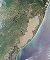
measures 7,491 km, which makes it the 16th longest national coastline of the world. All the coast lies adjacent to the Atlantic Ocean
Atlantic Ocean
The Atlantic Ocean is the second-largest of the world's oceanic divisions. With a total area of about , it covers approximately 20% of the Earth's surface and about 26% of its water surface area...
.
A considerable number of geographical features can be found all through the coastal areas, like islands, reefs and bays. The beaches of Brazil are famous in the world and receive a great number of tourists.
A famous expression in Brazil is "from Chuí
Chui
-Places:In Kyrgyzstan:*Chui Province*Chui RiverIn South America:*Chuí, Rio Grande do Sul*Chui Stream, on the Brazil-Uruguay borderIn SwahiliChui means Leopard...
to Oiapoque
Oiapoque
Oiapoque is a municipality in the north of the state of Amapá, Brazil. Its population is 11,449 and its area is 22,625 km². Oiapoque is also a major river in the same state, forming the international border with French Guiana...
", which means from the extreme south to the extreme north of the country. However, the actual northernmost point in Brazil is the Monte Caburaí
Monte Caburaí
Monte Caburaí is a mountain located on the border between the South American countries of Brazil and Guyana standing at above sea level. The source of the Uailã or Ailã river, located on the mountain, is the northernmost point of Brazil....
in the far from the coast state of Roraima
Roraima
Roraima is the northernmost and least populated state of Brazil, located in the Amazon region. It borders the states of Amazonas and Pará, as well as the nations of Venezuela and Guyana. The population is 400,000 and the capital is Boa Vista...
.
Out of the 26 Brazilian states, 9 are landlocked, as well as the Distrito Federal
Brazilian Federal District
The Federal District is set apart for Brasília, the capital of Brazil. Located in a region called Planalto Central, or Central Plateau, the Federal District is divided in 29 administrative regions. Brasilia - place where the three branches of the Federal Government are located - is the main...
. Most of the 17 coastal states have their capitals lying near the coast, exceptions being Porto alegre
Porto Alegre
Porto Alegre is the tenth most populous municipality in Brazil, with 1,409,939 inhabitants, and the centre of Brazil's fourth largest metropolitan area . It is also the capital city of the southernmost Brazilian state of Rio Grande do Sul. The city is the southernmost capital city of a Brazilian...
(Rio Grande do Sul
Rio Grande do Sul
Rio Grande do Sul is the southernmost state in Brazil, and the state with the fifth highest Human Development Index in the country. In this state is located the southernmost city in the country, Chuí, on the border with Uruguay. In the region of Bento Gonçalves and Caxias do Sul, the largest wine...
), Curitiba
Curitiba
Curitiba is the capital of the Brazilian state of Paraná. It is the largest city with the biggest economy of both Paraná and southern Brazil. The population of Curitiba numbers approximately 1.75 million people and the latest GDP figures for the city surpass US$61 billion according to...
(Paraná
Paraná (state)
Paraná is one of the states of Brazil, located in the South of the country, bordered on the north by São Paulo state, on the east by the Atlantic Ocean, on the south by Santa Catarina state and the Misiones Province of Argentina, and on the west by Mato Grosso do Sul and the republic of Paraguay,...
), São Paulo
São Paulo
São Paulo is the largest city in Brazil, the largest city in the southern hemisphere and South America, and the world's seventh largest city by population. The metropolis is anchor to the São Paulo metropolitan area, ranked as the second-most populous metropolitan area in the Americas and among...
(São Paulo
São Paulo (state)
São Paulo is a state in Brazil. It is the major industrial and economic powerhouse of the Brazilian economy. Named after Saint Paul, São Paulo has the largest population, industrial complex, and economic production in the country. It is the richest state in Brazil...
), Teresina
Teresina
Teresina is the capital and most populous municipality in the Brazilian state of Piauí. It is located in North-central Piauí 366 km from the coast.It is therefore, the only capital in the Northeast that is not located on the shores of the Atlantic Ocean. With 814 439 inhabitants, it is the 19th...
(Piauí
Piauí
Piauí is one of the states of Brazil, located in the northeastern part of the country.Piauí has the shortest coastline of any of the non-landlocked Brazilian states at 66 km , and the capital, Teresina, is the only state capital in the north east to be located inland...
), Belém
Belém
Belém is a Brazilian city, the capital and largest city of state of Pará, in the country's north region. It is the entrance gate to the Amazon with a busy port, airport and bus/coach station...
(Pará
Pará
Pará is a state in the north of Brazil. It borders the Brazilian states of Amapá, Maranhão, Tocantins, Mato Grosso, Amazonas and Roraima. To the northwest it also borders Guyana and Suriname, and to the northeast it borders the Atlantic Ocean. The capital is Belém.Pará is the most populous state...
) and Macapá
Macapá
Macapá is a Brazilian city, capital of Amapá state. Located in the North Region, it is the only state capital that has no highway connections with other capitals...
(Amapá
Amapá
Amapá is one of the states of Brazil, located in the extreme north, bordering French Guiana and Suriname to the north. To the east is the Atlantic Ocean, and to the south and west is the Brazilian state of Pará. Perhaps one of the main features of the state is the River Oiapoque, as it was once...
). Porto Alegre, Belém and Macapá lie all near large navigable rivers, though.
From South to North
Uruguay
Uruguay ,officially the Oriental Republic of Uruguay,sometimes the Eastern Republic of Uruguay; ) is a country in the southeastern part of South America. It is home to some 3.5 million people, of whom 1.8 million live in the capital Montevideo and its metropolitan area...
, at the city of Chuí
Chui
-Places:In Kyrgyzstan:*Chui Province*Chui RiverIn South America:*Chuí, Rio Grande do Sul*Chui Stream, on the Brazil-Uruguay borderIn SwahiliChui means Leopard...
. A few kilometers to the north, lies the Praia do Cassino
Praia do Cassino
Praia do Cassino is located adjacent to the city of Rio Grande, in the state of Rio Grande do Sul, Brazil. It is commonly known in Brazil as the longest beach in the world , stretching from the Molhes in Cassino beach to nearly Chuí, on...
, which is 254 km long. It is considered (especially by those within the country) to be the longest beach in the world, although other beaches around the globe are also claimed as the record keepers. Nevertheless, it is indeed the longest in Brazil.
Florianópolis
Florianópolis
-Climate:Florianópolis experiences a warm humid subtropical climate, falling just short of a true tropical climate. The seasons of the year are distinct, with a well-defined summer and winter, and characteristic weather for autumn and spring. Frost is infrequent, but occurs occasionally in the winter...
, the capital of Santa Catarina
Santa Catarina (state)
Santa Catarina is a state in southern Brazil with one of the highest standards of living in Latin America. Its capital is Florianópolis, which mostly lies on the Santa Catarina Island. Neighbouring states are Rio Grande do Sul to the south and Paraná to the north. It is bounded on the east by...
, is located on one of the largest coastal islands of Brazil, the Ilha de Santa Catarina
Santa Catarina (island)
Florianópolis Island is an island in the Brazilian state of Santa Catarina. It is located on the south coast of Brazil between the south 27° latitude and west 48° longitude...
, with an area of 424,4 km². The Serra do Mar
Serra do Mar
Serra do Mar is a 1,500 km long system of mountain ranges and escarpments in Southeastern Brazil, which runs in parallel to the Atlantic Ocean coast from the state of Espírito Santo to southern Santa Catarina, although some include Serra Geral in the Serra do Mar, in which case this range...
mountain range starts in Santa Catarina, and runs along the coastlines of Paraná, São Paulo, Rio de Janeiro
Rio de Janeiro (state)
Rio de Janeiro is one of the 27 states of Brazil.Rio de Janeiro has the second largest economy of Brazil behind only São Paulo state.The state of Rio de Janeiro is located within the Brazilian geopolitical region classified as the Southeast...
and Espírito Santo
Espírito Santo
Espírito Santo is one of the states of southeastern Brazil, often referred to by the abbreviation "ES". Its capital is Vitória and the largest city is Vila Velha. The name of the state means literally "holy spirit" after the Holy Ghost of Christianity...
.
The coastline of Paraná is small if compared to other states. However, it is very diverse geographically, with a considerable number of islands and bays.
Guarujá
Guarujá is a municipality in the São Paulo state of Brazil. The population in 2006 was 305,171, the population density is 1,969.47/km² and the area is 143 km². This place name comes from the Tupi language, and mean "narrow path". The population is highly urbanized.-Geography:Guarujá is...
, São Sebastião
São Sebastião, São Paulo
São Sebastião is a Brazilian city, located on the southeast coast of Brazil, in the state of São Paulo. The population in 2006 is 75,886, its density is 188.1/km² and the area is 403 km². The Tropic of Capricorn lies 25 km north...
and Ilhabela. The northern half of the coastline of São Paulo, as well as half the coastline of Rio de Janeiro are the only ones in Brazil to face the south (if small bays and islands spread in the rest of the country are not taken into account).
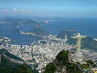
The state of Rio de Janeiro's coastline is remarkable for the worldwide known beaches in the capital city, like Ipanema
Ipanema
For other uses, see Ipanema . For the British rock band, see Ipanema .Ipanema is a neighborhood located in the southern region of the city of Rio de Janeiro, Brazil, between Leblon and Arpoador...
and Copacabana. Also, the state features the Campos Basin
Campos Basin
Campos Basin is a petroleum rich area located offshore of Rio de Janeiro, Brazil. It has a total area of 100,000 square kilometres, with 40 fields discovered and operated by Petrobras....
, the largest petroleum rich area in Brazil, measuring 100,000 km² and producing 1.49 million barrels of oil every day. The basin extends to the coastline of Espírito Santo. 1,200 km east of Vitória, in Espírito Santo, lie the islands of Trindade and Martim Vaz
Trindade and Martim Vaz
Trindade and Martim Vaz is an archipelago located about 1,200 kilometers east of Vitória in the Southern Atlantic Ocean, belonging to the State of Espírito Santo, Brazil. The archipelago has a total area of 10.4 km² and a population of 32...
.
Bahia
Bahia is one of the 26 states of Brazil, and is located in the northeastern part of the country on the Atlantic coast. It is the fourth most populous Brazilian state after São Paulo, Minas Gerais and Rio de Janeiro, and the fifth-largest in size...
has the longest coastline of the Brazilian states, and also the greatest number of coastal municipalities. Porto Seguro
Porto Seguro
Porto Seguro is a municipality in the Brazilian state of Bahia. It is the site where the Portuguese explorer Pedro Álvares Cabral first set foot on Brazilian soil on April 22, 1500...
is regarded as the first place in which Pedro Álvares Cabral
Pedro Álvares Cabral
Pedro Álvares Cabral was a Portuguese noble, military commander, navigator and explorer regarded as the discoverer of Brazil. Cabral conducted the first substantial exploration of the northeast coast of South America and claimed it for Portugal. While details of Cabral's early life are sketchy, it...
, discoverer of Brazil, set foot. Salvador
Salvador, Bahia
Salvador is the largest city on the northeast coast of Brazil and the capital of the Northeastern Brazilian state of Bahia. Salvador is also known as Brazil's capital of happiness due to its easygoing population and countless popular outdoor parties, including its street carnival. The first...
was the first capital of Brazil, and still boasts well-preserved buildings of the colonial
Colonial Brazil
In the history of Brazil, Colonial Brazil, officially the Viceroyalty of Brazil comprises the period from 1500, with the arrival of the Portuguese, until 1815, when Brazil was elevated to kingdom alongside Portugal as the United Kingdom of Portugal, Brazil and the Algarves.During the over 300 years...
and imperial periods of Brazil.
From Sergipe
Sergipe
Sergipe , is the smallest state of the Brazilian Federation, located on the northeastern Atlantic coast of the country. It borders on two other states, Bahia to the south and west and Alagoas to the north, and to the east is the Atlantic Ocean...
to Ceará
Ceará
Ceará is one of the 27 states of Brazil, located in the northeastern part of the country, on the Atlantic coast. It is currently the 8th largest Brazilian State by population and the 17th by area. It is also one of the main touristic destinations in Brazil. The state capital is the city of...
, the landscape changes little. The majority of the coastal areas have few or no mountains, whereas most of the islands are separated from the continent only by narrow channels. Temperatures are rather warm during most of the year, with moderate winds blowing frequently.
Piauí
Piauí
Piauí is one of the states of Brazil, located in the northeastern part of the country.Piauí has the shortest coastline of any of the non-landlocked Brazilian states at 66 km , and the capital, Teresina, is the only state capital in the north east to be located inland...
has a coastline of only some 60 km, the shortest of the country. Four cities (Cajueiro da Praia, Ilha Grande
Ilha Grande, Piauí
Ilha Grande is one of the four coastal cities of Piauí, Brazil. It is also the northernmost city of the state....
Luís Correia and Parnaíba
Parnaíba
Parnaíba is a port city in Piauí, Brazil, on the right bank of the Parnaíba River, 360 km north of the capital, Teresina. It is one of the only four coastal cities of the state....
) make up the coast of the state.
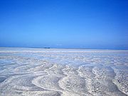
Lençóis Maranhenses National Park
The Lençóis Maranhenses National Park is located in Maranhão state, in northeastern Brazil, just east of the Baía de São José, between 02º19’—02º45’ S and 42º44’—43º29’ W. It is an area of low, flat, occasionally flooded land, overlaid with large, discrete sand dunes...
) are present. The area between Maranhão and Pará is dominated by the "Reentrâncias Maranhenses", a landform similar to a fjord
Fjord
Geologically, a fjord is a long, narrow inlet with steep sides or cliffs, created in a valley carved by glacial activity.-Formation:A fjord is formed when a glacier cuts a U-shaped valley by abrasion of the surrounding bedrock. Glacial melting is accompanied by rebound of Earth's crust as the ice...
but shorter, narrower and lower. Because of this particular geography, there are almost no beaches at this section of the Brazilian coastline.
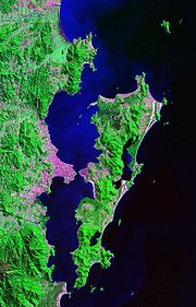
Half the coastline of Pará is composed of the mouth of the Amazon River, which flows towards the sea around the Marajó island, the largest island surrounded by fresh water in the world. The outflow of the Amazon river is so strong that the ocean waters in the north and northeast faces of the island have almost no salt.
Amapá's coastline has almost 600 km, but there are only three beaches: Fazendinha, Boca do Inferno and Goiabal. The coastline of Brazil ends at Cape Orange
Cape Orange
Cape Orange is a cape on the coast of Brazil, separated from the coast of French Guiana by a large bay watered by the estuary of the Oyapock River . Cape Orange is the northernmost point of the Brazilian state of Amapá...
, in the city of Oiapoque.
See also
- Geography of BrazilGeography of BrazilThe country of Brazil occupies roughly half of South America, bordering the Atlantic Ocean. Brazil covers a total area of which includes of land and of water. The highest point in Brazil is Pico da Neblina at...
- List of beaches in Brazil
- List of islands of Brazil