
Clatsop County, Oregon
Encyclopedia
Clatsop County is a county located in the U.S. state
of Oregon
. The county is named
for the Clatsop
tribe of Native Americans
, who lived along the coast of the Pacific Ocean
prior to European settlement. As of 2010, the population was 37,039. The county seat
is Astoria
.
, the county seat, has multiple tourist attractions including the Astoria Riverfront Trolley, Fort Clatsop
, the Uppertown Fire Fighters Museum, and Columbia River Maritime Museum
. Seaside, Oregon
, noted as Oregon’s oldest ocean resort community, also has multiple tourist attractions including, the Seaside Aquarium
, and the Seaside Historical Society Museum. Tourism is noted as one of the major forces in Clatsop County's economy.
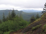
, the county has a total area of 1085 square miles (2,810.1 km²), of which 827 square miles (2,141.9 km²) is land and 258 square miles (668.2 km²) (23.74%) is water. The highest point is Saddle Mountain
at 3,283 feet (1,001 m), part of the Northern Oregon Coast Range
.
of 2000, there were 35,630 people, 14,703 households, and 9,454 families residing in the county. The population density
was 43 people per square mile (17/km²). There were 19,685 housing units at an average density of 24 per square mile (9/km²). The racial makeup of the county was 93.14% White
, 0.52% Black
or African American
, 1.03% Native American
, 1.21% Asian
, 0.17% Pacific Islander
, 1.64% from other races
, and 2.30% from two or more races. 4.48% of the population were Hispanic
or Latino
of any race. 15.3% were of German, 10.8% English
, 10.4% Irish
, 9.3% American
and 6.5% Norwegian ancestry.
There were 14,703 households out of which 28.50% had children under the age of 18 living with them, 50.60% were married couples
living together, 9.70% had a female householder with no husband present, and 35.70% were non-families. 29.50% of all households were made up of individuals and 11.70% had someone living alone who was 65 years of age or older. The average household size was 2.35 and the average family size was 2.88.
In the county, the population was spread out with 23.70% under the age of 18, 8.90% from 18 to 24, 25.30% from 25 to 44, 26.60% from 45 to 64, and 15.60% who were 65 years of age or older. The median age was 40 years. For every 100 females there were 97.80 males. For every 100 females age 18 and over, there were 95.10 males.
The median income for a household in the county was $36,301, and the median income for a family was $44,575. Males had a median income of $32,153 versus $22,479 for females. The per capita income
for the county was $19,515. About 9.10% of families and 13.20% of the population were below the poverty line, including 16.80% of those under age 18 and 8.00% of those age 65 or over.
stayed for the winter of 1805-6 in the area of the future county at Fort Clatsop
. Astoria
, Oregon's oldest city, was established as a fur trading post in 1811 and named after John Jacob Astor
.
Clatsop County was created from the northern and western portions of the original Twality District on June 22, 1844. Until the creation of Vancouver District five days later, Clatsop County extended north across the Columbia into present-day Washington. The Provisional and Territorial Legislatures further altered Clatsop County's boundaries in 1845 and 1853.
Before 1850 most of Clatsop County's government activity occurred in Lexington, a community located where Warrenton
is now. However, commercial and social activities came to center on Astoria as that city grew, and an election in 1854 chose Astoria to be the new county seat.
Fort Stevens
, located near the peninsula formed by the south shore of the Columbia river and the Pacific Ocean, became the only continental US military installation attacked in World War II
, when submarine I-25 of the Imperial Japanese Navy
fired 17 rounds at the base June 21, 1942. The submarine escaped when the order was given not to return fire with the 10 inches (254 mm) shore guns. This was done to so that the base position was not given away. While the damage caused was slight (reportedly only a baseball backstop was damaged and a powerline severed), the presence of the enemy ship sowed panic along the Pacific coast of the United States.
In 1975, Clatsop County commissioners considered seceding from Oregon, and become a part of Washington. The movement was based on disagreements residents of the county had with then-Oregon Governor Bob Straub. The movement was created after Alumax Corporation changed their plans of building a plant in the county. Some residents, including two county commissioners, blamed the Oregon Governor for the movement of the plant. Then-Washington Governor Daniel J. Evans
said the county was not welcome in the state of Washington. Clatsop County commissioners later abandoned the idea.
who won the county twice. In gubernatorial elections the county has been won by the Democratic Party candidate since, at least, 1990.
Clatsop County is located in Oregon's 1st congressional district
, which has a Cook Partisan Voting Index
of D+8 and is represented by David Wu
. In the Oregon State Senate
it is represented by Democrat Betsy Johnson. In the Oregon House of Representatives
it is represented by Democrats Brad Witt
and Deborah Boone
.
U.S. state
A U.S. state is any one of the 50 federated states of the United States of America that share sovereignty with the federal government. Because of this shared sovereignty, an American is a citizen both of the federal entity and of his or her state of domicile. Four states use the official title of...
of Oregon
Oregon
Oregon is a state in the Pacific Northwest region of the United States. It is located on the Pacific coast, with Washington to the north, California to the south, Nevada on the southeast and Idaho to the east. The Columbia and Snake rivers delineate much of Oregon's northern and eastern...
. The county is named
Oregon Geographic Names
Oregon Geographic Names is an authoritative compilation of the origin and meaning of place names in the U.S. state of Oregon. , the book is in its seventh edition and is compiled and edited by Lewis L. McArthur, who took over from his father, Lewis A. McArthur, as of the fourth edition...
for the Clatsop
Clatsop
The Clatsop are a small tribe of Chinookan-speaking Native Americans in the Pacific Northwest of the United States. In the early 19th century they inhabited an area of the northwestern coast of present-day Oregon from the mouth of the Columbia River south to Tillamook.-Language:Clatsop in the...
tribe of Native Americans
Native Americans in the United States
Native Americans in the United States are the indigenous peoples in North America within the boundaries of the present-day continental United States, parts of Alaska, and the island state of Hawaii. They are composed of numerous, distinct tribes, states, and ethnic groups, many of which survive as...
, who lived along the coast of the Pacific Ocean
Pacific Ocean
The Pacific Ocean is the largest of the Earth's oceanic divisions. It extends from the Arctic in the north to the Southern Ocean in the south, bounded by Asia and Australia in the west, and the Americas in the east.At 165.2 million square kilometres in area, this largest division of the World...
prior to European settlement. As of 2010, the population was 37,039. The county seat
County seat
A county seat is an administrative center, or seat of government, for a county or civil parish. The term is primarily used in the United States....
is Astoria
Astoria, Oregon
Astoria is the county seat of Clatsop County, Oregon, United States. Situated near the mouth of the Columbia River, the city was named after the American investor John Jacob Astor. His American Fur Company founded Fort Astoria at the site in 1811...
.
Economy
The principal industries of Clatsop County are manufacturing, travel (primarily tourism), and trade. Fishing and timber are still important but contribute proportionally less to the county's employment and income than they used to. The county's average nonfarm employment was 17,480 in 2007. About 30% of the lands within the county boundaries belong to the state of Oregon, as part of the state forests. The Port of Astoria was created in 1914 to support trade and commerce.Tourism
Astoria, OregonAstoria, Oregon
Astoria is the county seat of Clatsop County, Oregon, United States. Situated near the mouth of the Columbia River, the city was named after the American investor John Jacob Astor. His American Fur Company founded Fort Astoria at the site in 1811...
, the county seat, has multiple tourist attractions including the Astoria Riverfront Trolley, Fort Clatsop
Fort Clatsop
Fort Clatsop was the encampment of the Lewis and Clark Expedition in the Oregon Country near the mouth of the Columbia River during the winter of 1805-1806...
, the Uppertown Fire Fighters Museum, and Columbia River Maritime Museum
Columbia River Maritime Museum
The Columbia River Maritime Museum is a museum of maritime history located about ten miles from the mouth of the Columbia River in Astoria, Oregon, U.S.. It has a national reputation for the quality of its exhibits and the scope of its collections and was the first museum in Oregon to meet...
. Seaside, Oregon
Seaside, Oregon
Seaside is a city in Clatsop County, Oregon, United States. The name Seaside is derived from Seaside House, a historic summer resort built in the 1870s by railroad magnate Ben Holladay. The city's population was 6,457 at the 2010 census.-History:...
, noted as Oregon’s oldest ocean resort community, also has multiple tourist attractions including, the Seaside Aquarium
Seaside Aquarium
The Seaside Aquarium is a privately owned aquarium in Seaside, Oregon, United States. It is one of the oldest aquariums on the West Coast.-History:...
, and the Seaside Historical Society Museum. Tourism is noted as one of the major forces in Clatsop County's economy.
Geography
According to the U.S. Census BureauUnited States Census Bureau
The United States Census Bureau is the government agency that is responsible for the United States Census. It also gathers other national demographic and economic data...
, the county has a total area of 1085 square miles (2,810.1 km²), of which 827 square miles (2,141.9 km²) is land and 258 square miles (668.2 km²) (23.74%) is water. The highest point is Saddle Mountain
Saddle Mountain (Clatsop County, Oregon)
Saddle Mountain is the tallest mountain in Clatsop County, Oregon. Part of the Oregon Coast Range, Saddle Mountain is in Saddle Mountain State Natural Area in the northwest corner of Oregon...
at 3,283 feet (1,001 m), part of the Northern Oregon Coast Range
Northern Oregon Coast Range
The Northern Oregon Coast Range is the northern section of the Oregon Coast Range, in the Pacific Coast Ranges physiographic region, located in the northwest portion of the state of Oregon, United States. This section of the mountain range, part of the Pacific Coast Ranges, contains peaks as high...
.
Major highways
-
 Oregon Route 26U.S. Route 26 in OregonIn the U.S. state of Oregon, U.S. Route 26 is a major cross-state state highway, connecting U.S. Route 101 on the Oregon Coast near Seaside with the Idaho state line east of Nyssa. Local highway names include the Sunset Highway No. 47, Mount Hood Highway No. 26, and John Day Highway No...
 -
 Oregon Route 30
 -
 Oregon Route 101U.S. Route 101 in OregonIn the U.S. state of Oregon, U.S. Route 101, a major north–south U.S. Highway, runs through the state along the coastline near the Pacific Ocean. In Oregon, it runs from the Oregon–California border, south of Brookings, to the Oregon–Washington border on the Columbia River, between Astoria,...
National protected areas
- Julia Butler Hansen National Wildlife Refuge (part)
- Lewis and Clark National and State Historical ParksLewis and Clark National and State Historical ParksThe Lewis and Clark National and State Historical Parks, in the vicinity of the mouth of the Columbia River, commemorate the Lewis and Clark Expedition...
(part) - Lewis and Clark National Wildlife RefugeLewis and Clark National Wildlife RefugeLewis and Clark National Wildlife Refuge, near the mouth of the Columbia River, provides wintering and resting areas for an estimated 1,000 tundra swans, 5,000 geese, and 30,000 ducks. Other species include shorebirds and bald eagles....
- Oregon Islands National Wildlife RefugeOregon Islands National Wildlife RefugeOregon Islands National Wildlife Refuge is a U.S. National Wildlife Refuge off the southwestern Oregon Coast. It is one of six National Wildlife Refuges comprising the Oregon Coast National Wildlife Refuge Complex...
(part)
Demographics
As of the censusCensus
A census is the procedure of systematically acquiring and recording information about the members of a given population. It is a regularly occurring and official count of a particular population. The term is used mostly in connection with national population and housing censuses; other common...
of 2000, there were 35,630 people, 14,703 households, and 9,454 families residing in the county. The population density
Population density
Population density is a measurement of population per unit area or unit volume. It is frequently applied to living organisms, and particularly to humans...
was 43 people per square mile (17/km²). There were 19,685 housing units at an average density of 24 per square mile (9/km²). The racial makeup of the county was 93.14% White
Race (United States Census)
Race and ethnicity in the United States Census, as defined by the Federal Office of Management and Budget and the United States Census Bureau, are self-identification data items in which residents choose the race or races with which they most closely identify, and indicate whether or not they are...
, 0.52% Black
Race (United States Census)
Race and ethnicity in the United States Census, as defined by the Federal Office of Management and Budget and the United States Census Bureau, are self-identification data items in which residents choose the race or races with which they most closely identify, and indicate whether or not they are...
or African American
Race (United States Census)
Race and ethnicity in the United States Census, as defined by the Federal Office of Management and Budget and the United States Census Bureau, are self-identification data items in which residents choose the race or races with which they most closely identify, and indicate whether or not they are...
, 1.03% Native American
Race (United States Census)
Race and ethnicity in the United States Census, as defined by the Federal Office of Management and Budget and the United States Census Bureau, are self-identification data items in which residents choose the race or races with which they most closely identify, and indicate whether or not they are...
, 1.21% Asian
Race (United States Census)
Race and ethnicity in the United States Census, as defined by the Federal Office of Management and Budget and the United States Census Bureau, are self-identification data items in which residents choose the race or races with which they most closely identify, and indicate whether or not they are...
, 0.17% Pacific Islander
Race (United States Census)
Race and ethnicity in the United States Census, as defined by the Federal Office of Management and Budget and the United States Census Bureau, are self-identification data items in which residents choose the race or races with which they most closely identify, and indicate whether or not they are...
, 1.64% from other races
Race (United States Census)
Race and ethnicity in the United States Census, as defined by the Federal Office of Management and Budget and the United States Census Bureau, are self-identification data items in which residents choose the race or races with which they most closely identify, and indicate whether or not they are...
, and 2.30% from two or more races. 4.48% of the population were Hispanic
Race (United States Census)
Race and ethnicity in the United States Census, as defined by the Federal Office of Management and Budget and the United States Census Bureau, are self-identification data items in which residents choose the race or races with which they most closely identify, and indicate whether or not they are...
or Latino
Race (United States Census)
Race and ethnicity in the United States Census, as defined by the Federal Office of Management and Budget and the United States Census Bureau, are self-identification data items in which residents choose the race or races with which they most closely identify, and indicate whether or not they are...
of any race. 15.3% were of German, 10.8% English
English people
The English are a nation and ethnic group native to England, who speak English. The English identity is of early mediaeval origin, when they were known in Old English as the Anglecynn. England is now a country of the United Kingdom, and the majority of English people in England are British Citizens...
, 10.4% Irish
Irish people
The Irish people are an ethnic group who originate in Ireland, an island in northwestern Europe. Ireland has been populated for around 9,000 years , with the Irish people's earliest ancestors recorded having legends of being descended from groups such as the Nemedians, Fomorians, Fir Bolg, Tuatha...
, 9.3% American
United States
The United States of America is a federal constitutional republic comprising fifty states and a federal district...
and 6.5% Norwegian ancestry.
There were 14,703 households out of which 28.50% had children under the age of 18 living with them, 50.60% were married couples
Marriage
Marriage is a social union or legal contract between people that creates kinship. It is an institution in which interpersonal relationships, usually intimate and sexual, are acknowledged in a variety of ways, depending on the culture or subculture in which it is found...
living together, 9.70% had a female householder with no husband present, and 35.70% were non-families. 29.50% of all households were made up of individuals and 11.70% had someone living alone who was 65 years of age or older. The average household size was 2.35 and the average family size was 2.88.
In the county, the population was spread out with 23.70% under the age of 18, 8.90% from 18 to 24, 25.30% from 25 to 44, 26.60% from 45 to 64, and 15.60% who were 65 years of age or older. The median age was 40 years. For every 100 females there were 97.80 males. For every 100 females age 18 and over, there were 95.10 males.
The median income for a household in the county was $36,301, and the median income for a family was $44,575. Males had a median income of $32,153 versus $22,479 for females. The per capita income
Per capita income
Per capita income or income per person is a measure of mean income within an economic aggregate, such as a country or city. It is calculated by taking a measure of all sources of income in the aggregate and dividing it by the total population...
for the county was $19,515. About 9.10% of families and 13.20% of the population were below the poverty line, including 16.80% of those under age 18 and 8.00% of those age 65 or over.
History
The Lewis and Clark ExpeditionLewis and Clark Expedition
The Lewis and Clark Expedition, or ″Corps of Discovery Expedition" was the first transcontinental expedition to the Pacific Coast by the United States. Commissioned by President Thomas Jefferson and led by two Virginia-born veterans of Indian wars in the Ohio Valley, Meriwether Lewis and William...
stayed for the winter of 1805-6 in the area of the future county at Fort Clatsop
Fort Clatsop
Fort Clatsop was the encampment of the Lewis and Clark Expedition in the Oregon Country near the mouth of the Columbia River during the winter of 1805-1806...
. Astoria
Astoria, Oregon
Astoria is the county seat of Clatsop County, Oregon, United States. Situated near the mouth of the Columbia River, the city was named after the American investor John Jacob Astor. His American Fur Company founded Fort Astoria at the site in 1811...
, Oregon's oldest city, was established as a fur trading post in 1811 and named after John Jacob Astor
John Jacob Astor
John Jacob Astor , born Johann Jakob Astor, was a German-American business magnate and investor who was the first prominent member of the Astor family and the first multi-millionaire in the United States...
.
Clatsop County was created from the northern and western portions of the original Twality District on June 22, 1844. Until the creation of Vancouver District five days later, Clatsop County extended north across the Columbia into present-day Washington. The Provisional and Territorial Legislatures further altered Clatsop County's boundaries in 1845 and 1853.
Before 1850 most of Clatsop County's government activity occurred in Lexington, a community located where Warrenton
Warrenton, Oregon
Warrenton is a city in Clatsop County, Oregon, United States. The city is named for D.K. Warren, an early settler. The population was 4,096 at the 2000 census.- History :...
is now. However, commercial and social activities came to center on Astoria as that city grew, and an election in 1854 chose Astoria to be the new county seat.
Fort Stevens
Fort Stevens
Fort Stevens may refer to one of two decommissioned American military forts:*Fort Stevens , a fort in Oregon that guarded the mouth of the Columbia River...
, located near the peninsula formed by the south shore of the Columbia river and the Pacific Ocean, became the only continental US military installation attacked in World War II
World War II
World War II, or the Second World War , was a global conflict lasting from 1939 to 1945, involving most of the world's nations—including all of the great powers—eventually forming two opposing military alliances: the Allies and the Axis...
, when submarine I-25 of the Imperial Japanese Navy
Imperial Japanese Navy
The Imperial Japanese Navy was the navy of the Empire of Japan from 1869 until 1947, when it was dissolved following Japan's constitutional renunciation of the use of force as a means of settling international disputes...
fired 17 rounds at the base June 21, 1942. The submarine escaped when the order was given not to return fire with the 10 inches (254 mm) shore guns. This was done to so that the base position was not given away. While the damage caused was slight (reportedly only a baseball backstop was damaged and a powerline severed), the presence of the enemy ship sowed panic along the Pacific coast of the United States.
In 1975, Clatsop County commissioners considered seceding from Oregon, and become a part of Washington. The movement was based on disagreements residents of the county had with then-Oregon Governor Bob Straub. The movement was created after Alumax Corporation changed their plans of building a plant in the county. Some residents, including two county commissioners, blamed the Oregon Governor for the movement of the plant. Then-Washington Governor Daniel J. Evans
Daniel J. Evans
Daniel Jackson Evans served three terms as the 16th Governor of the state of Washington from 1965 to 1977, and represented the state in the United States Senate from 1983 to 1989....
said the county was not welcome in the state of Washington. Clatsop County commissioners later abandoned the idea.
Politics
Although once Republican, in the last seven decades the county has generally been carried by the Democratic candidate in Presidential elections. The exception to this is Dwight D. EisenhowerDwight D. Eisenhower
Dwight David "Ike" Eisenhower was the 34th President of the United States, from 1953 until 1961. He was a five-star general in the United States Army...
who won the county twice. In gubernatorial elections the county has been won by the Democratic Party candidate since, at least, 1990.
Clatsop County is located in Oregon's 1st congressional district
Oregon's 1st congressional district
Oregon's 1st congressional district consists of the northwest corner of Oregon. It includes Clatsop, Columbia, Washington, and Yamhill counties, and southwest Portland, part of Multnomah County, which belonged to the 3rd district before the 2002 redistricting....
, which has a Cook Partisan Voting Index
Cook Partisan Voting Index
The Cook Partisan Voting Index , sometimes referred to as simply the Partisan Voting Index , is a measurement of how strongly an American congressional district or state leans toward one political party compared to the nation as a whole...
of D+8 and is represented by David Wu
David Wu
David Wu is an American politician who served as the U.S. representative for from 1999 to 2011. He is a member of the Democratic Party.The district includes most of Portland west of the Willamette River, as well as all of Yamhill, Columbia, Clatsop, and Washington Counties...
. In the Oregon State Senate
Oregon State Senate
The Oregon State Senate is the upper house of the state-wide legislature for the U.S. state of Oregon. Along with the lower chamber Oregon House of Representatives it makes up the Oregon Legislative Assembly. There are 30 members of the State Senate, representing 30 districts across the state,...
it is represented by Democrat Betsy Johnson. In the Oregon House of Representatives
Oregon House of Representatives
The Oregon House of Representatives is the lower house of the Oregon Legislative Assembly. There are 60 members of the House, representing 60 districts across the state, each with a population of 57,000. The House meets at the Oregon State Capitol in Salem....
it is represented by Democrats Brad Witt
Brad Witt
Bradley "Brad" Witt is a Democratic member of the Oregon House of Representatives for District 31, representing most of Columbia and parts of Clatsop and Multnomah counties, since his appointment in January 2005....
and Deborah Boone
Deborah Boone
Deborah Boone is a Democratic member of the Oregon House of Representatives, representing District 32 since her appointment on August 4, 2004, to serve out the remaining term of Representative Elaine Hopson...
.
Incorporated cities
- AstoriaAstoria, OregonAstoria is the county seat of Clatsop County, Oregon, United States. Situated near the mouth of the Columbia River, the city was named after the American investor John Jacob Astor. His American Fur Company founded Fort Astoria at the site in 1811...
- Cannon BeachCannon Beach, OregonCannon Beach is a city in Clatsop County, Oregon, United States. The population was 1,588 as of the 2000 census. The 2007 estimate is 1,680 residents.- History :...
- GearhartGearhart, OregonGearhart is a city in Clatsop County, Oregon, United States. The population was 995 at the 2000 census. The 2007 estimate is 1,185 residents.- Geography :...
- SeasideSeaside, OregonSeaside is a city in Clatsop County, Oregon, United States. The name Seaside is derived from Seaside House, a historic summer resort built in the 1870s by railroad magnate Ben Holladay. The city's population was 6,457 at the 2010 census.-History:...
- WarrentonWarrenton, OregonWarrenton is a city in Clatsop County, Oregon, United States. The city is named for D.K. Warren, an early settler. The population was 4,096 at the 2000 census.- History :...
Unincorporated communities
|
Navy Heights, Oregon Navy Heights is an unincorporated community in Clatsop County, Oregon, United States. It began as a housing project in nearby Astoria 97103.... Necanicum, Oregon Necanicum is a historic unincorporated community in Clatsop County, Oregon, United States. It is located about 13 miles southeast of Seaside on U.S. Route 26 in the Northern Oregon Coast Range, next to the Necanicum River. Necanicum Junction is about a mile east of the site of the former post... (historical) Olney, Oregon Olney is an unincorporated community and former company town in Clatsop County, Oregon, United States, on Oregon Route 202 about eight miles south of Astoria.... Sunset Beach, Oregon Sunset Beach is a small unincorporated community located between the cities of Seaside and Warrenton in Clatsop County, Oregon, United States. Sunset Beach is located between U.S. Route 101, Neacoxie Lake and the Pacific Ocean. It serves as the northernmost access to the resort community of Surf... Surf Pines, Oregon Surf Pines is an unincorporated community in Clatsop County, Oregon, United States. It is a private gated community, located three miles north of Gearhart, just west of U.S. Route 101.... Svensen, Oregon Svensen is an unincorporated community on the Columbia River in Clatsop County, Oregon, United States. According to Oregon Geographic Names, it is named after Peter Svensen, an early settler. There was a post office in Svensen from 1895 to 1944.... Tolovana Park, Oregon Tolovana Park is an unincorporated community in Clatsop County, Oregon, United States. Tolovana Park is located along the Pacific coast south of Cannon Beach. Tolovana Park has a post office with ZIP code 97145.... (within the city of Cannon Beach) Wauna, Oregon Wauna is an unincorporated community on the Columbia River in Clatsop County, Oregon. According to Oregon Geographic Names, it names a Native American mythological being associated with the Columbia River. There was a post office in Wauna from January 21, 1911 to circa 1980. Wauna is best known... Westport, Oregon Westport is an unincorporated community on the Columbia River in Clatsop County, Oregon, United States. Westport is connected to Cathlamet, Washington across the river via the Wahkiakum County Ferry to Puget Island. U.S... |
Adjacent counties
- Columbia County, OregonColumbia County, OregonColumbia County is a county located in the U.S. state of Oregon. It was named for the Columbia River, which forms its eastern and northern borders. As of 2010, its population was 49,351. The county seat is St. Helens.-Economy:...
- (east) - Pacific County, Washington - (north)
- Wahkiakum County, Washington - (north)
- Tillamook County, OregonTillamook County, OregonTillamook County is a county located in the U.S. state of Oregon. The county is named for the Tillamook, a Native American tribe who were living in the area in the early 19th century at the time of European American settlement. In 2010, the county's population was 25,250...
- (south) - Washington County, OregonWashington County, Oregon- Major highways :* Interstate 5* Interstate 205* U.S. Route 26* Oregon Route 6* Oregon Route 8* Oregon Route 10* Oregon Route 47* Oregon Route 99W* Oregon Route 210* Oregon Route 217* Oregon Route 219-Demographics:...
- (southeast)
See also
- National Register of Historic Places listings in Clatsop County, OregonNational Register of Historic Places listings in Clatsop County, OregonThis is a list of properties and districts in Clatsop County, Oregon that are listed on the National Register of Historic Places.- Current listings :...
- Seaside AquariumSeaside AquariumThe Seaside Aquarium is a privately owned aquarium in Seaside, Oregon, United States. It is one of the oldest aquariums on the West Coast.-History:...