

Chattahoochee-Oconee National Forest
Encyclopedia
Georgia (U.S. state)
Georgia is a state located in the southeastern United States. It was established in 1732, the last of the original Thirteen Colonies. The state is named after King George II of Great Britain. Georgia was the fourth state to ratify the United States Constitution, on January 2, 1788...
comprises two United States National Forest
United States National Forest
National Forest is a classification of federal lands in the United States.National Forests are largely forest and woodland areas owned by the federal government and managed by the United States Forest Service, part of the United States Department of Agriculture. Land management of these areas...
s, the Oconee National Forest and Chattahoochee National Forest. The combined total area of the Chattahoochee-Oconee National Forest is 865855 acres (3,504 km²), of which the Chattahoochee National Forest comprises 750502 acres (3,037 km²) and the Oconee National Forest comprises 115353 acres (467 km²). The county with the largest portion of the forest is Rabun County
Rabun County, Georgia
Rabun County is a county located in the U.S. state of Georgia. As of the 2000 census, the population was 15,050. The 2007 Census Estimate shows a population of 16,519...
, Georgia
Georgia (U.S. state)
Georgia is a state located in the southeastern United States. It was established in 1732, the last of the original Thirteen Colonies. The state is named after King George II of Great Britain. Georgia was the fourth state to ratify the United States Constitution, on January 2, 1788...
, which has 148684 acres (601.7 km²) within its boundaries.
History
The Chattahoochee National Forest takes its name from the Chattahoochee RiverChattahoochee River
The Chattahoochee River flows through or along the borders of the U.S. states of Georgia, Alabama, and Florida. It is a tributary of the Apalachicola River, a relatively short river formed by the confluence of the Chattahoochee and Flint Rivers and emptying into Apalachicola Bay in the Gulf of...
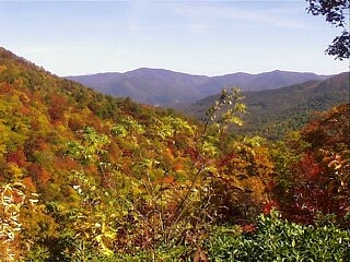
whose headwaters begin in the North Georgia mountains
North Georgia mountains
The Georgia Mountains Region or North Georgia mountains or Northeast Georgia is an area that starts in the northeast corner of Georgia, United States, and spreads in a westerly direction. The mountains in this region are in the Blue Ridge mountain chain that ends in Georgia...
. The River and the area were given the name by the English settlers who took the name from the Indians living here. The Cherokee
Cherokee
The Cherokee are a Native American people historically settled in the Southeastern United States . Linguistically, they are part of the Iroquoian language family...
and Creek Indians inhabited North Georgia. In one dialect of the Muskogean languages
Muskogean languages
Muskogean is an indigenous language family of the Southeastern United States. Though there is an ongoing debate concerning their interrelationships, the Muskogean languages are generally divided into two branches, Eastern Muskogean and Western Muskogean...
, Chatta means stone; ho chee, marked or flowered. These marked or flowered stones were in the Chattahoochee River at a settlement near Columbus, Georgia
Columbus, Georgia
Columbus is a city in and the county seat of Muscogee County, Georgia, United States, with which it is consolidated. As of the 2010 census, the city had a population of 189,885. It is the principal city of the Columbus, Georgia metropolitan area, which, in 2009, had an estimated population of 292,795...
.
United States Forest Service
The United States Forest Service is an agency of the United States Department of Agriculture that administers the nation's 155 national forests and 20 national grasslands, which encompass...
purchased 31000 acres (125 km²) of land in Fannin
Fannin County, Georgia
Fannin County is a county located in the U.S. state of Georgia. It was created on January 21, 1854. As of 2000, the population was 19,798. The 2007 Census Estimate shows a population of 22,580...
, Gilmer
Gilmer County, Georgia
Gilmer County is a county located in the U.S. state of Georgia. It was created on December 3, 1832 and was named for George Rockingham Gilmer. As of 2000, the population was 23,456. The 2007 Census Estimate shows a population of 28,389...
, Lumpkin
Lumpkin County, Georgia
Lumpkin County is a county located in the U.S. state of Georgia. As of the 2010 census, the population was 29,966. Its county seat is Dahlonega.- History :...
and Union
Union County, Georgia
Union County is a county located in the U.S. state of Georgia. As of 2000, the population was 17,289. The 2007 Census Estimate shows a population of 20,968. The county seat is Blairsville.Its Sole commissioner is Lamar Paris, who has served since 2001....
Counties from the Gennett family for $7 per acre. This land was the beginning of what would become the Chattahoochee National Forest. The initial land purchases became a part of the Cherokee National Forest
Cherokee National Forest
The Cherokee National Forest is a large National Forest created on July 19, 1936, by U.S. President Franklin Roosevelt, operated by the U.S. Forest Service and encompassing some 640,000 acres .-Location:...
on June 14, 1920.
Ranger Roscoe Nicholson
Roscoe Nicholson
Roscoe Nicholson was a surveyor and early advocate of conservation, who played an important role in preserving forest land in the U.S. state of Georgia in the early 20th century....
, who was the first forest ranger in Georgia and had advised the Forest Service in its initial land purchases, continued the growth of the Chattahoochee by negotiating the purchase of most of the Forest Service land in what is now the Chattooga River Ranger District. The Coleman River Scenic Area
Coleman River Scenic Area
The Coleman River Scenic Area is located in Rabun County, Georgia in the Chattooga River District of the Chattahoochee National Forest. It is located at the point of confluence of Coleman River with the Tallulah River. The scenic area consists of encompassing lower Coleman River and was dedicated...
near Clayton, Georgia
Clayton, Georgia
Clayton is a city in Rabun County, Georgia, United States. The population was 2,019 at the 2000 census. The city is the county seat of Rabun County and is located in the Blue Ridge Mountains.-History:...
was dedicated to "Ranger Nick", as he was called, in honor of his promotion of conservation ideals.
Ranger Arthur Woody
Arthur Woody
Arthur Woody was born in Suches, Georgia. Arthur Woody, who saw his father kill the last deer in the North Georgia mountains in 1895, is credited with bringing deer back to the North Georgia mountains...
also promoted conservation and was a key figure in the early development of the Chattahoochee. Unwise land and resource use had caused the deer and trout
Trout
Trout is the name for a number of species of freshwater and saltwater fish belonging to the Salmoninae subfamily of the family Salmonidae. Salmon belong to the same family as trout. Most salmon species spend almost all their lives in salt water...
populations to virtually disappear in the North Georgia mountains
North Georgia mountains
The Georgia Mountains Region or North Georgia mountains or Northeast Georgia is an area that starts in the northeast corner of Georgia, United States, and spreads in a westerly direction. The mountains in this region are in the Blue Ridge mountain chain that ends in Georgia...
and Woody brought trout and deer back to the area. The trout were shipped to Gainesville, hauled across the narrow, dirt, mountain roads and eventually released in the streams
STREAMS
In computer networking, STREAMS is the native framework in Unix System V for implementing character devices.STREAMS was designed as a modular architecture for implementing full-duplex I/O between kernel or user space processes and device drivers. Its most frequent uses have been in developing...
. Woody also purchased fawns with his own money, and fed them until they could be released on what became the Blue Ridge Wildlife Management Area
Blue Ridge Wildlife Management Area
The Blue Ridge Wildlife Management Area consists of located in the Chattahoochee National Forest in Dawson, Fannin and Lumpkin counties in Georgia....
. Many landmarks in the Chattahoochee bear Ranger Woody’s name in tribute to his work. Sosebee Cove
Sosebee Cove
Sosebee Cove is a high-elevation, north-facing, cove forest found in the Chattahoochee National Forest. The trail through the cove is dedicated to Arthur Woody, who negotiated the Cove's purchase for the United States Forest Service...
, a 175 acre (0.7082005 km²) tract of prize hardwood along GA 180 is set aside as a memorial to Woody, who negotiated its purchase for the Forest Service.
On July 9, 1936, the Forest Service was reorganized to follow state boundaries and President Franklin D. Roosevelt
Franklin D. Roosevelt
Franklin Delano Roosevelt , also known by his initials, FDR, was the 32nd President of the United States and a central figure in world events during the mid-20th century, leading the United States during a time of worldwide economic crisis and world war...
proclaimed the Chattahoochee a separate National Forest. In 1936, the Chattahoochee was organized into two Ranger Districts, the Blue Ridge and the Tallulah.
In 1959, President Dwight D. Eisenhower
Dwight D. Eisenhower
Dwight David "Ike" Eisenhower was the 34th President of the United States, from 1953 until 1961. He was a five-star general in the United States Army...
proclaimed 96000 acres (388 km²) of federal lands in central Georgia
Central Georgia
Central Georgia refers to the region containing the metropolitan region surrounding the city of Macon, in Bibb County in the U.S. state of Georgia....
as the Oconee National Forest. The Oconee then joined the Chattahoochee to become the Chattahoochee-Oconee National Forests of today.
The Chattooga River
Chattooga River
The Chattooga River is the main tributary of the Tugaloo River. Its headwaters are located southwest of Cashiers, North Carolina, and it stretches to where it has its confluence with the Tallulah River within Lake Tugalo, held back by the Tugalo Dam...
was designated a Wild and Scenic River during the 1970s. The Chattooga remains one of the few free-flowing streams in the Southeast and is known for its white water rafting and beautiful scenery. The movie Deliverance
Deliverance
Deliverance is a 1972 American thriller film produced and directed by John Boorman. Principal cast members include Jon Voight, Burt Reynolds, Ronny Cox and Ned Beatty in his film debut. The film is based on a 1970 novel of the same name by American author James Dickey, who has a small role in the...
was filmed on the Chattooga River, which became the fictional Cahulawassee River in the movie.
Today
The Chattahoochee National Forest today covers 18 north Georgia counties. The Chattahoochee currently has three ranger districts:- Blue Ridge Ranger District, Office in Blairsville, GA
- Chattooga River Ranger District, Office in Tallulah Falls, GA
- Conasauga Ranger District, Office in Chattsworth, GA
It includes over 2200 miles (3,540.5 km) of rivers and streams (including about 1367 miles (2,200 km) of trout
Trout
Trout is the name for a number of species of freshwater and saltwater fish belonging to the Salmoninae subfamily of the family Salmonidae. Salmon belong to the same family as trout. Most salmon species spend almost all their lives in salt water...
streams). There are over 450 miles (724.2 km) of hiking
Hiking
Hiking is an outdoor activity which consists of walking in natural environments, often in mountainous or other scenic terrain. People often hike on hiking trails. It is such a popular activity that there are numerous hiking organizations worldwide. The health benefits of different types of hiking...
and other recreation trails
Trails of the Chattahoochee National Forest
There are 86 trails maintained by the U.S. Forest Service in the Chattahoochee National Forest in the State of Georgia. These trails include:...
, and 1600 miles (2,574.9 km) of "roads." In addition to the Chattooga River and the headwaters of the Chattahoochee River, natural attractions within it boundaries include the beginning of the 2174 miles (3,499 km) Appalachian Trail
Appalachian Trail
The Appalachian National Scenic Trail, generally known as the Appalachian Trail or simply the AT, is a marked hiking trail in the eastern United States extending between Springer Mountain in Georgia and Mount Katahdin in Maine. It is approximately long...
, Georgia's highpoint, Brasstown Bald
Brasstown Bald
Brasstown Bald is the highest natural point in the state of Georgia, USA, with a summit elevation of 4,784 feet above mean sea level....
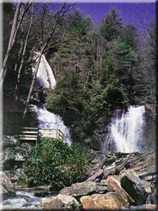
and Anna Ruby Falls
Anna Ruby Falls
Anna Ruby Falls is located near Unicoi State Park in White County near Helen, Georgia. The waterfall is accessible via a half mile trail from a public use area with a small admittance charge...
.
The Chattahoochee also includes ten wildernesses that are part of the National Wilderness Preservation System
National Wilderness Preservation System
The National Wilderness Preservation System of the United States protects federally managed land areas designated for preservation in their natural condition. It was established by the Wilderness Act upon the signature of President Lyndon B. Johnson on September 3, 1964...
. all of which are managed by the United States Forest Service. The wildernesses are:
- Big Frog WildernessBig Frog WildernessThe Big Frog Wilderness was designated in 1984 and currently consists of . Approximately are located in Georgia in the Chattahoochee National Forest and approximately are located in Tennessee in the Cherokee National Forest...
- Blood Mountain WildernessBlood Mountain WildernessThe Blood Mountain Wilderness was designated in 1991 and currently consists of . The Wilderness is located within the borders of the Chattahoochee National Forest in Lumpkin County and Union County, Georgia. The Wilderness is managed by the United States Forest Service and is part of the National...
- Brasstown WildernessBrasstown WildernessThe Brasstown Wilderness was designated in 1986 and currently consists of . The Wilderness is located within the borders of the Chattahoochee National Forest in Union County and Towns County, Georgia...
- Cohutta WildernessCohutta WildernessThe Cohutta Wilderness was designated in 1975, expanded in 1986, and currently consists of . Approximately are located in Georgia in the Chattahoochee National Forest and approximately are located in Tennessee in the Cherokee National Forest...
- Ellicott Rock WildernessEllicott Rock WildernessThe Ellicott Rock Wilderness was designated in 1975 and currently consists of surrounding the point at which Georgia, North Carolina, and South Carolina come together. It is the only wilderness that straddles three states...
- Mark Trail WildernessMark Trail WildernessThe Mark Trail Wilderness was designated in 1991 and currently consists of . It is named in honor of Mark Trail, a daily newspaper comic strip created by the American cartoonist Ed Dodd. The Wilderness is located within the borders of the Chattahoochee National Forest in White, Towns, and Union...
- Raven Cliffs WildernessRaven Cliffs WildernessThe Raven Cliffs Wilderness was designated in 1986 and currently consists of . The Wilderness is located within the borders of the Chattahoochee National Forest in White, Lumpkin, and Union Counties, Georgia...
- Rich Mountain WildernessRich Mountain WildernessThe Rich Mountain Wilderness is a wilderness area within the Chattahoochee National Forest in Gilmer County, Georgia, in the United States. It was designated in 1986 and currently consists of of the that makes up the Rich Mountains...
- Southern Nantahala WildernessSouthern Nantahala WildernessThe Southern Nantahala Wilderness was designated in 1984 and currently consists of . Approximately are located in Georgia in the Chattahoochee National Forest and approximately are located in North Carolina in the Nantahala National Forest. The Wilderness is managed by the United States Forest...
- Tray Mountain WildernessTray Mountain WildernessThe Tray Mountain Wilderness was designated in 1986 and currently consists of . The Wilderness is located within the borders of the Chattahoochee National Forest in Habersham, Rabun, Towns and White counties, Georgia and is managed in the Chattooga Ranger District...
The Oconee National Forest today is spread over eight Georgia counties and is organized into one ranger district. The Oconee Ranger District
Oconee Ranger District
The Oconee Ranger District is the ranger district that serves the Oconee National Forest, one of two forests that are combined into the Chattahoochee-Oconee National Forest. The district is spread over eight Georgia, United States, counties...
maintains several hiking and other recreational trails in the forest
Trails of the Oconee National Forest
There are 10 trails maintained by the U.S. Forest Service in the Oconee National Forest. These trails include:*Boarding House Trail*Burgess Mountain Trail*Hitchiti Trail*Indian Mounds Trail*Kinnard Creek Trail*Ocmulgee River Trail...
. Forest headquarters are located in Gainesville, Georgia
Gainesville, Georgia
-Severe Weather:Gainesville sits on the very fringe of Tornado Alley, a region of the United States where severe weather is common. Supercell thunderstorms can sweep through any time between March and November, but are concentrated most in the spring...
.
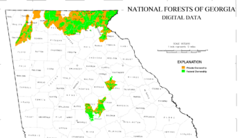
Georgia counties
Listed below are the counties with land in the Forest showing the area and the relevant ranger districts.Chattooga River Ranger District
- Banks CountyBanks County, GeorgiaBanks County is a county located in the U.S. state of Georgia. As of 2010, the population is 18,395. The county seat is Homer.-History:*The Georgia General Assembly passed legislation to create Banks County on February 1, 1859, from Franklin and Habersham Counties.*The county is named for Richard...
, 650 acres (2.6 km²) - Stephens CountyStephens County, GeorgiaStephens County is a county located in the U.S. state of Georgia. According to the 2010 Census, the population was 26,175. The 2007 Census Estimate shows a population of 25,268. The county seat is Toccoa.-History:...
, 23304 acres (94 km²) - Habersham CountyHabersham County, GeorgiaHabersham County is a county located in the U.S. state of Georgia. It was created on December 15, 1818, and named for Colonel Joseph Habersham. As of 2000, the population was 35,902. The 2007 Census Estimate shows a population of 42,272. Clarkesville is the county seat.Chartered in 1823, the...
, 39933 acres (162 km²) - White CountyWhite County, GeorgiaWhite County is a county located in the northeast corner of the U.S. state of Georgia. It was created on December 22, 1857, from part of Habersham County. The county was named for Newton County Representative David T. White, who helped a Habersham representative successfully attain passage of an...
, 41526 acres (168 km²) - Rabun CountyRabun County, GeorgiaRabun County is a county located in the U.S. state of Georgia. As of the 2000 census, the population was 15,050. The 2007 Census Estimate shows a population of 16,519...
, 148575 acres (601 km²)
Conasauga Ranger District
- Catoosa CountyCatoosa County, GeorgiaCatoosa County is a county located in the U.S. state of Georgia. It was created on December 5, 1853. As of 2000, the population was 53,282. The 2007 Census Estimate shows a population of 62,241...
, 6 acre (0.02428116 km²) - Chattooga CountyChattooga County, GeorgiaChattooga County is a county located in the U.S. state of Georgia. It was created on December 28, 1838. As of 2000, the population was 25,470. The 2007 Census Estimate shows a population of 26,797. The county seat is Summerville.-Geography:...
, 19390 acres (78 km²) - Floyd CountyFloyd County, GeorgiaFloyd County is a county located in the U.S. state of Georgia. As of 2000, the population was 90,565. Census estimates for 2007 show a population of 95,618...
, 6620 acres (27 km²) - Gilmer CountyGilmer County, GeorgiaGilmer County is a county located in the U.S. state of Georgia. It was created on December 3, 1832 and was named for George Rockingham Gilmer. As of 2000, the population was 23,456. The 2007 Census Estimate shows a population of 28,389...
, 23098 acres (93 km²) - Gordon CountyGordon County, GeorgiaGordon County is a county located in the U.S. state of Georgia. As of 2000, the population was 44,104. The 2007 Census Estimate shows a population of 52,044. The county seat is Calhoun.- History :...
, 8076 acres (33 km²) - Murray CountyMurray County, GeorgiaMurray County is a county located in the U.S. state of Georgia. As of 2000, the population was 36,506. The 2007 Census Estimate showed a population of 40,664. The county seat is Chatsworth.It is part of the Dalton, Georgia, Metropolitan Statistical Area....
, 51696 acres (209 km²) - Walker CountyWalker County, GeorgiaWalker County is a county located in the U.S. state of Georgia. It was created on December 18, 1833 from land formerly belonging to the Cherokee Indian Nation. As of 2000, the population was 61,053. The 2007 Census Estimate shows a population of 64,554...
, 18844 acres (76 km²) - Whitfield CountyWhitfield County, GeorgiaWhitfield County is a county located in the U.S. state of Georgia. It was created on December 30, 1851. The 2010 Census shows a population of 102,599. The county seat is Dalton.It is part of the Dalton, Georgia, Metropolitan Statistical Area.-Civil War:...
, 11732 acres (47 km²)
Blue Ridge Ranger District District
- Dawson County, 6760 acres (27 km²)
- Fannin CountyFannin County, GeorgiaFannin County is a county located in the U.S. state of Georgia. It was created on January 21, 1854. As of 2000, the population was 19,798. The 2007 Census Estimate shows a population of 22,580...
, 106130 acres (429 km²) - Gilmer CountyGilmer County, GeorgiaGilmer County is a county located in the U.S. state of Georgia. It was created on December 3, 1832 and was named for George Rockingham Gilmer. As of 2000, the population was 23,456. The 2007 Census Estimate shows a population of 28,389...
, 32285 acres (131 km²) - Lumpkin CountyLumpkin County, GeorgiaLumpkin County is a county located in the U.S. state of Georgia. As of the 2010 census, the population was 29,966. Its county seat is Dahlonega.- History :...
, 57005 acres (231 km²) - Towns CountyTowns County, GeorgiaTowns County is a county located in the U.S. state of Georgia. It was created on March 6, 1856. As of the 2000 census, the population was 9,319. The 2007 Census Estimate shows a population of 10,894. Its county seat is Hiawassee.-History:...
, 57481 acres (233 km²) - Union CountyUnion County, GeorgiaUnion County is a county located in the U.S. state of Georgia. As of 2000, the population was 17,289. The 2007 Census Estimate shows a population of 20,968. The county seat is Blairsville.Its Sole commissioner is Lamar Paris, who has served since 2001....
, 97839 acres (396 km²)
Oconee National Forest
The Oconee National Forest is almost halfway between MaconMacon, Georgia
Macon is a city located in central Georgia, US. Founded at the fall line of the Ocmulgee River, it is part of the Macon metropolitan area, and the county seat of Bibb County. A small portion of the city extends into Jones County. Macon is the biggest city in central Georgia...
and Athens
Athens, Georgia
Athens-Clarke County is a consolidated city–county in U.S. state of Georgia, in the northeastern part of the state, comprising the former City of Athens proper and Clarke County. The University of Georgia is located in this college town and is responsible for the initial growth of the city...
. There are several man-made lakes in the region that are available for public watercraft. Hiking and camping are encouraged, but there are some places in the forest that are considered to be private land. Galingayle, a master planned community in Madison
Madison, Georgia
Madison is a city in Morgan County, Georgia, United States. The population was 3,636 at the 2000 census. The city is the county seat of Morgan County....
, is an example of some of the private land that is not available to outsiders unless they are with a member. These communities work with park rangers to ensure that their lifestyle has little or no impact on the environment.
Oconee Ranger District
- Greene CountyGreene County, GeorgiaGreene County is a county located in the U.S. state of Georgia. It was created on February 3, 1786. As of 2000, the population is 14,406. The 2007 Census Estimate shows a population of 15,662. The county seat is Greensboro...
, 26659 acres (108 km²) - Jasper CountyJasper County, GeorgiaJasper County is a county located in the U.S. state of Georgia. As of 2000, the population was 11,426. The 2007 Census Estimate shows a population of 13,660...
, 30517 acres (123 km²) - Jones CountyJones County, GeorgiaJones County is a county located in the U.S. state of Georgia. It was created on December 10, 1807. As of 2010, the population was 27,740 . The county seat is Gray.-History:The county is named after U.S...
, 16757 acres (68 km²) - Monroe CountyMonroe County, GeorgiaMonroe County is a county located in the U.S. state of Georgia. It was created on May 15, 1821. As of 2000, the population was 21,757. The 2007 Census Estimate showed a population of 25,145...
, 251 acres (1 km²) - Morgan CountyMorgan County, GeorgiaMorgan County is a county located in the U.S. state of Georgia. As of 2000, the population was 15,457. The 2005 Census Estimate shows a population of 17,492. The county seat is Madison, Georgia.-Geography:...
, 308 acres (1.2 km²) - Oconee CountyOconee County, GeorgiaOconee County is a county located in the U.S. state of Georgia. It was created on February 25, 1875. As of the 2000 census, the population was 26,225. Census estimates for 2007 show a population of 31,367...
, 157 acre (0.63535702 km²) - Oglethorpe CountyOglethorpe County, GeorgiaOglethorpe County is a county located in the U.S. state of Georgia. It is the largest county in Northeast Georgia. As of 2000, the population was 12,635. The 2007 Census Estimate showed a population of 13,963...
, 3762 acres (15 km²) - Putnam CountyPutnam County, GeorgiaPutnam County is a county located in the U.S. state of Georgia. As of 2000, the population was 18,812. The 2007 Census Estimate showed a population of 21,251...
, 37981 acres (154 km²)