
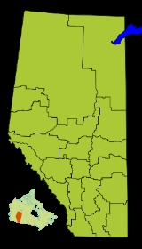
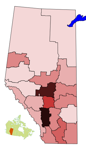
Census divisions of Alberta
Encyclopedia
Statistics Canada
Statistics Canada is the Canadian federal government agency commissioned with producing statistics to help better understand Canada, its population, resources, economy, society, and culture. Its headquarters is in Ottawa....
divides the province of Alberta
Alberta
Alberta is a province of Canada. It had an estimated population of 3.7 million in 2010 making it the most populous of Canada's three prairie provinces...
into nineteen census division
Census division
Census division is an official term in Canada and the United States. The census divisions of Canada are second-level census geographic unit, below provinces and territories, and above "census subdivisions" and "dissemination areas". In provinces where they exist, the census division may correspond...
s. Unlike in some other provinces, census divisions do not reflect a level of local government in Alberta.
Alberta's census divisions consist of numerous census subdivisions. The types of census subdivisions within an Alberta census division may include:
- cities, towns, villages, and summer villages (urban municipalities);
- specialized municipalitiesSpecialized municipalities of AlbertaA specialized municipality is a type of municipal status used in the Canadian Province of Alberta. Alberta specialized municipalities are unique local governments that can be formed without resorting to special acts of Alberta's legislature...
; - municipal districts, special areas, and improvement districts (rural municipalities);
- Indian reserves; and
- Indian settlementIndian settlementAn Indian settlement is a census subdivision outlined by the Canadian government Department of Indian and Northern Affairs Canada for census purposes. These areas have at least 10 Indian people who live, more or less, permanently in the given area...
s.
List of census divisions
| Div. |
Pop. |
Area (km²) |
Density (/km²) |
Largest urban community |
Specialized/rural municipalities |
|---|---|---|---|---|---|
| 1 Division No. 1, Alberta Division No. 1 is a census division in Alberta, Canada. It is located in the southeast corner of southern Alberta and surrounds the City of Medicine Hat.- Census subdivisions :... |
Medicine Hat Medicine Hat, Alberta Medicine Hat, known to locals as "The Hat", is a city of 61,097 people located in the southeastern part of the province of Alberta, Canada. It is enclaved within Cypress County along with the nearby Town of Redcliff, although neither is part of the county.... |
Cypress County Cypress County, Alberta Cypress County is a municipal district located in southeastern Alberta, Canada. The County completely surrounds the City of Medicine Hat and the Town of Redcliff.The municipality is part of Census Division 1, Alberta.- Geography :... Forty Mile County Forty Mile County No. 8, Alberta The County of Forty Mile No. 8 is a municipal district in south eastern Alberta, Canada.It is located in Census Division 1, east of Medicine Hat. The municipal seat is in Foremost.-Demographics:... |
|||
| 2 Division No. 2, Alberta Division No. 2 is a census division in Alberta, Canada. It is located in the south-central portion of southern Alberta and includes the City of Lethbridge.- Census subdivisions :... |
Lethbridge Lethbridge Lethbridge is a city in the province of Alberta, Canada, and the largest city in southern Alberta. It is Alberta's fourth-largest city by population after Calgary, Edmonton and Red Deer, and the third-largest by area after Calgary and Edmonton. The nearby Canadian Rockies contribute to the city's... |
County of Lethbridge Lethbridge County, Alberta The County of Lethbridge is a municipal district in southern Alberta. It is in Census Division 2 and part of the Lethbridge Census Agglomeration area.-Demographics:... County of Newell Taber MD Taber, Alberta (municipal district) The Municipal District of Taber is a municipal district in southern Alberta, Canada. It is located in Census Division 2.-Demographics:The population of the Municipal District of Taber according to its 2008 municipal census is 6,714.... Warner County Warner County No. 5, Alberta The County of Warner No. 5 is a municipal district in southern Alberta, Canada.It is located in Census Division 2, just north of the United States border. Warner was organised as a rural municipality since 1912, and established in the actual borders since 1954. The seat of the municipality is... |
|||
| 3 Division No. 3, Alberta Division No. 3 is a census division in Alberta, Canada. It is located in the southwest corner of southern Alberta and its largest urban community is the Town of Claresholm.- Census subdivisions :... |
Claresholm Claresholm, Alberta Claresholm is a town located within southern Alberta, Canada. It is located on Highway 2, approximately northwest of the City of Lethbridge and south of the City of Calgary. The town is the seat of the Municipal District of Willow Creek No... |
Cardston County Cardston County, Alberta Cardston County is a municipal district in southern Alberta, Canada. It is located in Census Division 3 around the Town of Cardston.The municipal district was established on January 1, 1954, through the amalgamation of the Municipal District of Sugar City No. 5 and part of the Municipal District of... Improvement District No. 4 Pincher Creek MD Pincher Creek No. 9, Alberta The Municipal District of Pincher Creek No. 9 is a municipal district in south western Alberta, Canada.It is located in Census Division 3. It was established in the current boundaries in 1944, when the name was changed from Municipal District of Crowsnest No. 39 to Municipal District of Pincher... Willow Creek MD Willow Creek No. 26, Alberta The Municipal District of Willow Creek No. 26 is a municipal district in southern Alberta, Canada.It is located in Census Division 3. The district was incorporated on Jan 01, 1954 and has the municipal seat in the Town of Claresholm.-Demographics:... |
|||
| 4 Division No. 4, Alberta Division No. 4 is a census division in Alberta, Canada. It is located in the northeast corner of southern Alberta and its largest urban community is the Town of Hanna. Division No... |
Hanna Hanna, Alberta Hanna is a town in east-central Alberta, Canada.The town's main industries are agriculture, oil production, tourism, and coal mining. It is the centre of a large trading area called Short Grass County and is the home of approximately 200 businesses... |
Acadia MD Acadia No. 34, Alberta The Municipal District of Acadia No. 34 is a municipal district in southern Alberta, Canada, east of Calgary, close to the Saskatchewan border, in Census Division No. 4.... Special Area 2 Special Area No. 2, Alberta Special Area No. 2 is a special area in southern Alberta, Canada. It is a rural municipality similar to a municipal district, however, the elected council is overseen by three representatives appointed by the province, the Special Areas Board.... Special Area 3 Special Area No. 3, Alberta Special Area No. 3 is a special area in southern Alberta, Canada. It is a rural municipality similar to a municipal district, however, the elected council is overseen by three representatives appointed by the province, the Special Areas Board.... Special Area 4 Special Area No. 4, Alberta Special Area No. 4 is a special area in central Alberta, Canada. It is a rural municipality similar to a municipal district, however, the elected council is overseen by three representatives appointed by the province, the Special Areas Board.... |
|||
| 5 Division No. 5, Alberta Division No. 5 is a census division in Alberta, Canada. It is located in the north-central portion of southern Alberta and its largest urban community is the Town of Strathmore.- Census subdivisions :... |
Strathmore Strathmore, Alberta Strathmore is a town located along the Trans-Canada Highway in southern Alberta, Canada, east of the city of Calgary, within the boundaries of Wheatland County.- History :... |
Kneehill County Kneehill County, Alberta Kneehill County is a municipal district situated in Division No. 5, Alberta, central Alberta.The presence of oil and natural gas in the region has attracted some industry.-Demographics:... Starland County Starland County, Alberta Starland County is a municipal district located in southern Alberta Canada.The municipality was incorporated in 1912, and established in the current boundaries in 1943, under the name Municipal District of Morrin No. 277. The name was changed the same year to Municipal District of Starland No. 277... Vulcan County Vulcan County, Alberta Vulcan County is a municipal district in Alberta, Canada.It is located in Census Division 6. The current boundaries of the municipality were set in 1951... Wheatland County Wheatland County, Alberta Wheatland County is a municipal district in south-central Alberta, Canada, east of Calgary.It is located in Census Division 5. The municipal seat is the Town of Strathmore.-Demographics:... |
|||
| 6 Division No. 6, Alberta Division No. 6 is a census division in Alberta, Canada. Surrounding the City of Calgary, the majority of the division comprises Alberta's Calgary Region, while the northern portion of the division is located within central Alberta. The division also forms the southern segment of the... |
Calgary Calgary Calgary is a city in the Province of Alberta, Canada. It is located in the south of the province, in an area of foothills and prairie, approximately east of the front ranges of the Canadian Rockies... |
Foothills MD Foothills No. 31, Alberta The Municipal District of Foothills No. 31 is a municipal district in southern Alberta, Canada adjacent to the south side of Calgary in Census Division No. 6... Mountain View County Mountain View County, Alberta Mountain View County is a municipal district in Division No. 6 in the central Alberta, Canada. It is located between the cities of Calgary and Red Deer within the Calgary-Edmonton corridor. Mountain View County is a member of the Central Alberta Economic Partnership, Alberta Association of... Rocky View County |
|||
| 7 Division No. 7, Alberta Division No. 7 is a census division in Alberta, Canada. It is located in the southeast corner of central Alberta and its largest urban community is the Town of Wainwright.- Census subdivisions :... |
Wainwright Wainwright, Alberta Wainwright is a town on the prairies of east-central Alberta, Canada.It is located on the north side of the Canadian National Railway, with CFB Wainwright located on the southwest side. The town lies south of Vermilion, in the Battle River valley, along Highway 41, called the Buffalo Trail.... |
Flagstaff County Flagstaff County, Alberta Flagstaff County is a municipal district in east central Alberta, Canada.It is located in Census Division 7. The county was incorporated in the current boundaries in 1944 as Municipal District of Killam No. 390, name changed a year later to Municipal District of Flagstaff No. 62. It was established... Paintearth County Paintearth County No. 18, Alberta The County of Paintearth No. 18 is a municipal district in east central Alberta, Canada.It is located in Census Division 7. Incorporated in the current boundaries in 1944 as the Municipal District of Paintearth No. 334, it was established as a county in 1962. The municipal seat is in the Town of... Provost MD Provost No. 52, Alberta The Municipal District of Provost No. 52 is a municipal district in east-central Alberta, Canada, on the Alberta/Saskatchewan border.It is located in Census Division 12. The municipal district was established in the current boundaries in 1943, through the amalgamation of the Municipal Districts of... Stettler County Stettler County No. 6, Alberta The County of Stettler No. 6 is a municipal district in central Alberta, Canada.-Demographics:In 2006, the County of Stettler No. 6 had a population of 5,216 living in 1,846 dwellings, a 2.6% decrease from 2001. The county has a land area of and a population density of .In 2001, the population... Wainwright MD Wainwright No. 61, Alberta The Municipal District of Wainwright No. 61 is a municipal district in eastern Alberta, Canada.It is located in Census Division 7. The seat of the municipality is set in the Town of Wainwright. The district is bisected north-south by the Buffalo Trail and east-west by the Poundmaker... |
|||
| 8 Division No. 8, Alberta Division No. 8 is a census division in Alberta, Canada. It is located in the south-central portion of central Alberta and surrounds the City of Red Deer. The division forms the central segment of the Calgary–Edmonton Corridor. Division No... |
Red Deer Red Deer, Alberta Red Deer is a city in Central Alberta, Canada. It is located near the midpoint of the Calgary-Edmonton Corridor and is surrounded by Red Deer County. It is Alberta's third-most-populous city – after Calgary and Edmonton. The city is located in aspen parkland, a region of rolling hills... |
Lacombe County Lacombe County, Alberta Lacombe County is a municipal district in central Alberta, Canada.It is located in Census Division 8, north of the city of Red Deer. The municipal seat of the county lies in Lacombe.Highway 2 bisects the county.-Demographics:... Ponoka County Ponoka County, Alberta Ponoka County is a municipal district in Alberta, Canada. It covers and it claims to "embody the essence of rural Alberta" .-Demographics:In 2006, Ponoka County had a population of 8,640 living in 3,330 dwellings, a 1.7% decrease from 2001... Red Deer County Red Deer County, Alberta Red Deer County is a municipal district in central Alberta, Canada in Division No. 8 and is where the City of Red Deer is located. The neighbouring municipalities of Red Deer County are the Clearwater County to the west, Lacombe County to the north, Stettler County to the east, and to the south are... |
|||
| 9 Division No. 9, Alberta Division No. 9 is a census division in Alberta, Canada. It is located in the southwest corner of central Alberta and its largest urban community is the Town of Rocky Mountain House... |
Rocky Mountain House Rocky Mountain House, Alberta Rocky Mountain House is a town in west-central Alberta, Canada, approximately west of the City of Red Deer. It is located at the confluence of the Clearwater and North Saskatchewan Rivers, and at the crossroads of Highway 22 and Highway 11 .- History :The town has a long history dating to the... |
Clearwater County Clearwater County, Alberta Clearwater County is a municipal district in west central Alberta, Canada in Division No. 9. Its northwest boundary is the Brazeau River. The municipal seat is located in the town of Rocky Mountain House, which is enclaved within, and technically outside the bounds of the county... |
|||
| 10 Division No. 10, Alberta Division No. 10 is a census division in Alberta, Canada. It is located in the east-central portion of central Alberta and includes Alberta's portion of the City of Lloydminster.- Census subdivisions :... |
Lloydminster Lloydminster Lloydminster is a Canadian city which has the unusual geographic distinction of straddling the provincial border between Alberta and Saskatchewan... |
Beaver County Beaver County, Alberta Beaver County is a municipal district in central-east Alberta, Canada. It is centred around Holden, and has the municipal seat in Ryley, in the western part of Census Division No. 10.... Camrose County Improvement District 13 Lamont County Lamont County, Alberta Lamont County is a municipal district in central Alberta, Canada, located in Census Division Number 10, northeast of Edmonton. The county contains 27 Townships. Its seat of government is Lamont.-History:... Minburn County Minburn County No. 27, Alberta The County of Minburn No. 27 is a municipal district in east central Alberta, Canada.It is located in Census Division 10. It was established as a county on Jan 01, 1965 from the former Municipal District of Minburn No. 72. The municipal seat is set in the Town of Vegreville.-Demographics:In 2006,... Two Hills County Two Hills County No. 21, Alberta The County of Two Hills No. 21 is a municipal district in east-central Alberta, Canada.It is located in Census Division 10. The county was formed in 1963, from the Municipal District of Eagle No. 81 and the Two Hills School Division. The seat of the county is in the Town of Two... Vermilion River County |
|||
| 11 Division No. 11, Alberta Division No. 11 is a census division in Alberta, Canada. Surrounding the City of Edmonton, the majority of the division comprises Alberta's Capital Region, while the western and southern portions of the division are located within central Alberta... |
Edmonton Edmonton Edmonton is the capital of the Canadian province of Alberta and is the province's second-largest city. Edmonton is located on the North Saskatchewan River and is the centre of the Edmonton Capital Region, which is surrounded by the central region of the province.The city and its census... |
Brazeau County Brazeau County, Alberta Brazeau County is a municipal district in central Alberta, Canada. It is located in Census Division 11.The municipality was created on July 1, 1988 from Improvement District No. 222. On October 1, 2002, the name was changed from Municipal District of Brazeau No... Leduc County Leduc County, Alberta Leduc County is a municipal district located immediately south of the City of Edmonton. It is east to west and north to south, and has a population of over 12,000 people. The municipal district is home to scenic prairie parkland and several lakes... Parkland County Parkland County, Alberta Parkland County is a municipal district in central Alberta, Canada.It is located west of Edmonton in Census Division No. 11, along the Parkland Highway... Strathcona County Strathcona County, Alberta Strathcona County is a specialized municipality in central Alberta, Canada between Edmonton and Elk Island National Park.It is located in Division No. 11 and is also part of the Edmonton Census Metropolitan Area. More than half of the population lives in Sherwood Park, a large community east of... Sturgeon County Sturgeon County, Alberta Sturgeon County is a municipal district in Alberta's Edmonton Capital Region, Canada.It begins at the north end of Edmonton, with 97th street turning into Highway 28. It extends east to Fort Saskatchewan and west to Calahoo. It is located in Division No. 11.... County of Wetaskiwin No. 10 Wetaskiwin County No. 10, Alberta The County of Wetaskiwin No. 10 is a municipal district in central Alberta, Canada, south of Edmonton.It is located in Census Division 11. The County seat is in Wetaskiwin.-Demographics:... |
|||
| 12 Division No. 12, Alberta Division No. 12 is a census division in Alberta, Canada. Including the City of Cold Lake, the majority of the division is located in the northeast corner of central Alberta, while the northern portion of the division is located within northern Alberta.... |
Cold Lake Cold Lake, Alberta Cold Lake is a city in northeastern Alberta, Canada, named after the lake it is situated near.-Geography:The city is situated in Alberta's "Lakeland" district, 300 km northeast of Edmonton, near the Alberta-Saskatchewan provincial border. The area surrounding the city is sparsely populated,... |
Bonnyville MD Bonnyville No. 87, Alberta The Municipal District of Bonnyville No. 87 is a municipal district in northeastern Alberta, Canada in Division No. 12. Its located adjacent to the province of Saskatchewan, on the east.... Lac La Biche County Smoky Lake County Smoky Lake County, Alberta Smoky Lake County is a municipal district in north-eastern Alberta, Canada.It is located in Census Division 12. The county seat is in the Town of Smoky Lake.-Demographics:... St. Paul County St. Paul County No. 19, Alberta The County of St. Paul No. 19 is a municipal district in northeast Alberta, Canada.It is located in Census Division 12. It was previously known as the Municipal District of St. Paul No. 86 until January 1, 1962 when it became the County of St. Paul No. 19. The municipal seat is in the Town of St.... |
|||
| 13 Division No. 13, Alberta Division No. 13 is a census division in Alberta, Canada. The majority of the division is located in the north-central portion of central Alberta, while the northeast portion of the division is located within northern Alberta... |
Whitecourt Whitecourt, Alberta Whitecourt is a town in Alberta, Canada within Woodlands County. It is located northwest of Edmonton and southeast of Grande Prairie at the junction of Highway 43 and Highway 32 and has an elevation of .... |
Athabasca County County of Barrhead No. 11 Lac Ste. Anne County Lac Ste. Anne County, Alberta Lac Ste. Anne County is a municipal district in central Alberta, Canada.It is located in Census Division 13, north west of Edmonton. Highway 43 stretches across this county. The municipal seat is located in the Hamlet of Sangudo.... Thorhild County Thorhild County No. 7, Alberta The County of Thorhild No. 7, Alberta is a municipal district located in the central part of northern Alberta, Canada in Census Division 13. It was incorporated as a county in 1955.... Westlock County Westlock County, Alberta Westlock County is a municipal district in central Alberta north of Edmonton. The county was formerly known as the Municipal District of Westlock No. 92, and was created in 1943 from the merger of five smaller municipal districts.... Woodlands County Woodlands County, Alberta Woodlands County is a municipal district in north-central Alberta, Canada.It is located in Census Division 13. The municipal seat is in the Town of Whitecourt, while a regional administrative office is also located in the Hamlet of Fort Assiniboine.... |
|||
| 14 Division No. 14, Alberta Division No. 14 is a census division in Alberta, Canada. The majority of the division is located in the western portion of central Alberta, while the westernmost portion of the division is located within Alberta's Rockies... |
Hinton Hinton, Alberta Hinton is a town in west-central Alberta, Canada.It is located in Yellowhead County, northeast of Jasper and about west of Alberta's capital city, Edmonton, at the intersection of Yellowhead and Bighorn Highway, in the Athabasca River valley.-History:... |
Improvement District 25 Willmore Wilderness Park Willmore Wilderness Park, located in Alberta, Canada, is a 4,600 square kilometre wilderness area adjacent to the world famous Jasper National Park... Yellowhead County Yellowhead County, Alberta Yellowhead County is a municipal district in west central Alberta, Canada.It is the only county in Alberta Division 14, and shares the boundaries with this census division.-History:*1994: Established as a Municipal District of Yellowhead No... |
|||
| 15 Division No. 15, Alberta Division No. 15 is a census division in Alberta, Canada. The majority of the division is located in Alberta's Rockies, while the southernmost portion of the division is located within southern Alberta... |
Canmore Canmore, Alberta Canmore is a town in Alberta, Canada, located approximately west of the City of Calgary near the southeast boundary of Banff National Park. It is located in the Bow Valley within Alberta's Rockies. The town shares a border with Kananaskis Country to the west and south and the Municipal District of... |
Bighorn MD Bighorn No. 8, Alberta The Municipal District of Bighorn No. 8 is a municipal district situated in Census Division No. 15 of Alberta, Canada. It is located between Calgary and Banff National Park, north of Kananaskis Improvement District. Highway 1 bisects this county.It was created as a municipal district on January 1,... Crowsnest Pass Crowsnest Pass, Alberta The Municipality of Crowsnest Pass is a specialized municipality located in the Crowsnest Pass of the Rocky Mountains in southwest Alberta, Canada. The municipality formed as a result of the amalgamation of five municipalities – the Village of Bellevue, the Town of Blairmore, Town of Coleman, the... Improvement District 9 Improvement District 12 Jasper Jasper, Alberta Jasper is a specialized municipality in western Alberta, Canada. It is the commercial centre of Jasper National Park, located in the Canadian Rockies in the Athabasca River valley.... Kananaskis I.D. Kananaskis Improvement District Kananaskis Improvement District is an improvement district in Alberta, Canada. It is located within Alberta's Rockies, sharing much of its boundaries with Kananaskis Country.The administrative centre of the improvement district is Kananaskis Village.... Ranchland MD Ranchland No. 66, Alberta The Municipal District of Ranchland No. 66 is a municipal district in south western Alberta, Canada.It is located in Census Division 15. The municipality was incorporated on 1995 from the Improvement District No. 6. The municipal seat is in the Town of Nanton, located within the boundaries of... |
|||
| 16 Division No. 16, Alberta Division No. 16 is a census division in Alberta, Canada. It is located in the northeast portion of northern Alberta and surrounds the Urban Service Area of Fort McMurray.- Census subdivisions :... |
Fort McMurray | Improvement District 24 Wood Buffalo Wood Buffalo, Alberta The Regional Municipality of Wood Buffalo is a specialized municipality located in northeastern Alberta. Formed as a result of the amalgamation of the City of Fort McMurray and Improvement District No. 143 on April 1, 1995, it is the second largest municipality in Alberta by area... |
|||
| 17 Division No. 17, Alberta Division No. 17 is a census division in Alberta, Canada. It spans the central and northwest portions of northern Alberta and its largest urban community is the Town of Slave Lake. Division No... |
Slave Lake Slave Lake, Alberta Slave Lake is a town in northern Alberta, Canada, in the Municipal District of Lesser Slave River No. 124. It is located on the southeast shore of Lesser Slave Lake at the junction of Highway 2 and Highway 88.... |
Big Lakes MD Big Lakes, Alberta The Municipal District of Big Lakes is a municipal district in north-central Alberta, Canada.It is located in Census Division 17, around the Lesser Slave Lake. Utikuma Lake and Winagami Lake are also located in this municipal district.-Demographics:... Clear Hills County Clear Hills County, Alberta Clear Hills County is a municipal district in north western Alberta, Canada. It is located in Census Division 17.On Jan 01, 2006, the name was changed from Municipal District of Clear Hills No... Northern Sunrise County Northern Sunrise County, Alberta Northern Sunrise County is a municipal district in northern Alberta, Canada. It is located in Census Division 17.On July 10, 2002, the name changed from Municipal District of East Peace No. 131 to Northern Sunrise County... Lesser Slave River MD Mackenzie County County of Northern Lights Opportunity MD Opportunity No. 17, Alberta The Municipal District of Opportunity No. 17 is a municipal district occupying a large remote area in central northern Alberta, Canada.It is located in Census Division 17 north of Athabasca. The municipal seat is in Wabasca. It was established as a municipal district on Aug 01, 1995, from the... |
|||
| 18 Division No. 18, Alberta Division No. 18 is a census division in Alberta, Canada. It is located in the southeast corner of northern Alberta and its largest urban community is the Town of Grande Cache. The boundaries of the division are coextensive with the outer boundaries of the Municipal District of Greenview No... |
Grande Cache Grande Cache, Alberta Grande Cache is a town in west-central Alberta, Canada, located northwest of Hinton and west of Edmonton. It is located in the Municipal District of Greenview, between Highway 40 and the Smoky River, at the northern border of Alberta's Rockies... |
Greenview MD Greenview No. 16, Alberta The Municipal District of Greenview No. 16 is a municipal district in northwest Alberta, Canada.It covers the full extent of Census Division 18. The municipal seat is in Valleyview.- Demographics :... |
|||
| 19 Division No. 19, Alberta Division No. 19 is a census division in Alberta, Canada. It is located in the west-central portion of northern Alberta and surrounds the City of Grande Prairie.- Census subdivisions :... |
Grande Prairie | Birch Hills County Birch Hills County, Alberta Birch Hills County is a municipal district in north-western Alberta, Canada. It is located in Census Division 19, north-east of Grande Prairie.-Demographics:The population of Birch Hills County according to its 2008 municipal census is 1,610.... Fairview MD Fairview No. 136, Alberta The Municipal District of Fairview No. 136 is a municipal district in northwestern Alberta, Canada. It is located in Census Division 19.The district stretches along the northwestern leg of Highway 2.- Demographics :... County of Grande Prairie Grande Prairie County No. 1, Alberta The County of Grande Prairie No. 1 is a municipal district in northwestern Alberta, Canada in Census Division No. 19.It is bounded on the south by the Wapiti River, on the east by the Smoky River and on the west by the province of British Columbia.... Peace MD Peace No. 135, Alberta The Municipal District of Peace No. 135 is a municipal district in northwestern Alberta, Canada.It is located in Census Division 19. The municipal seat is set in the Village of Berwyn.- Demographics :... Saddle Hills County Saddle Hills County, Alberta Saddle Hills County is a municipal district situated in the Central Peace Country of west-northern Alberta, Canada. It is located approximately north-west of Edmonton and north of Grande Prairie.... Smoky River MD Smoky River No. 130, Alberta The Municipal District of Smoky River No. 130 is a municipal district in north western Alberta, Canada.It is located in Census Division 19. The municipal seat is set in Town of Falher. On Jan 01, 1952, the name was changed from Municipal District of Fillion No... Spirit River MD Spirit River No. 133, Alberta The Municipal District of Spirit River No. 133 is a municipal district in north western Alberta, Canada, north of Grande Prairie.It is located in Census Division 19. It was incorporated in 1916. The seat of the county is in the Town of Spirit River.... |
|||
See also
- List of communities in Alberta
- List of cities in Alberta
- List of towns in Alberta
- List of villages in Alberta
- List of summer villages in Alberta
- Specialized municipalities of AlbertaSpecialized municipalities of AlbertaA specialized municipality is a type of municipal status used in the Canadian Province of Alberta. Alberta specialized municipalities are unique local governments that can be formed without resorting to special acts of Alberta's legislature...
- List of municipal districts in Alberta
- List of hamlets in Alberta
- List of Indian reserves in Alberta
- List of designated places in Alberta
- List of urban areas in Alberta
- Subdivisions of Canada