
Division No. 17, Alberta
Encyclopedia
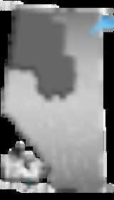
Division No. 17 is a census division
in Alberta
, Canada
. It spans the central and northwest portions of northern Alberta
and its largest urban community is the Town of Slave Lake
. Division No. 17 is the largest census division in Alberta according to area and also has the lowest population density.
, a 3.1% increase from 2001. The census division has a land area of 192084.34 km² (74,164.2 sq mi) and a population density
of 0.3 inhabitants per square kilometre.
Census division
Census division is an official term in Canada and the United States. The census divisions of Canada are second-level census geographic unit, below provinces and territories, and above "census subdivisions" and "dissemination areas". In provinces where they exist, the census division may correspond...
in Alberta
Alberta
Alberta is a province of Canada. It had an estimated population of 3.7 million in 2010 making it the most populous of Canada's three prairie provinces...
, Canada
Canada
Canada is a North American country consisting of ten provinces and three territories. Located in the northern part of the continent, it extends from the Atlantic Ocean in the east to the Pacific Ocean in the west, and northward into the Arctic Ocean...
. It spans the central and northwest portions of northern Alberta
Northern Alberta
Northern Alberta is a region located in the Canadian province of Alberta.Its primary industry is oil and gas, with large heavy oil reserves being exploited at the Athabasca Oil Sands and Wabasca Area in the east of the region...
and its largest urban community is the Town of Slave Lake
Slave Lake, Alberta
Slave Lake is a town in northern Alberta, Canada, in the Municipal District of Lesser Slave River No. 124. It is located on the southeast shore of Lesser Slave Lake at the junction of Highway 2 and Highway 88....
. Division No. 17 is the largest census division in Alberta according to area and also has the lowest population density.
Census subdivisions
The following census subdivisions (municipalities or municipal equivalents) are located within Alberta's Division No. 17.- Towns
- High LevelHigh Level, Alberta- Demographics :According to the 2006 census, High Level had a:*population of 3,887 living in 1,519 dwellings, a 12.9% increase from 2001;*land area of ; and*population density of .- Economy :...
- High Prairie
- ManningManning, AlbertaManning is a town in northern Alberta, Canada. It is known as the "Land of the Mighty Moose". It is located on Highway 35 north of Peace River on the Notikewin River.Manning is a service centre for the local agriculture, forestry and gas industries...
- Rainbow LakeRainbow Lake, AlbertaRainbow Lake is a small town in northern Alberta, Canada. It is located west of High Level at the end of Highway 58, in MacKenzie County.The town carries the name of the nearby lake, formed on the Hay River, that was so called due to its curved shape....
- Slave LakeSlave Lake, AlbertaSlave Lake is a town in northern Alberta, Canada, in the Municipal District of Lesser Slave River No. 124. It is located on the southeast shore of Lesser Slave Lake at the junction of Highway 2 and Highway 88....
- Swan HillsSwan Hills, AlbertaSwan Hills is a town in northern Alberta, Canada. It is located north of Whitecourt at the junction of Highway 32 and Grizzly Trail. Swan Hills is located in Municipal District of Big Lakes within census Division No...
- High Level
- Villages
- Hines CreekHines Creek, AlbertaHInes Creek is a village in northern Alberta, Canada. It is located 67 km west of Grimshaw and 28 km north of Fairview, along Highway 64.- Demographics :The population of the Village of Hines Creek according to its 2010 municipal census is 396....
- NampaNampa, AlbertaNampa is a village in northwestern Alberta located 27 km south of the Town of Peace River, along Highway 2. Heart River crosses the Highway 2 just north of community...
- Hines Creek
- Specialized municipalities
- Mackenzie County
- Municipal districts
- Big Lakes, M.D. ofBig Lakes, AlbertaThe Municipal District of Big Lakes is a municipal district in north-central Alberta, Canada.It is located in Census Division 17, around the Lesser Slave Lake. Utikuma Lake and Winagami Lake are also located in this municipal district.-Demographics:...
- Clear Hills CountyClear Hills County, AlbertaClear Hills County is a municipal district in north western Alberta, Canada. It is located in Census Division 17.On Jan 01, 2006, the name was changed from Municipal District of Clear Hills No...
- Lesser Slave River No. 124, M.D. of
- Northern Lights, County of
- Northern Sunrise CountyNorthern Sunrise County, AlbertaNorthern Sunrise County is a municipal district in northern Alberta, Canada. It is located in Census Division 17.On July 10, 2002, the name changed from Municipal District of East Peace No. 131 to Northern Sunrise County...
- Opportunity No. 17, M.D. ofOpportunity No. 17, AlbertaThe Municipal District of Opportunity No. 17 is a municipal district occupying a large remote area in central northern Alberta, Canada.It is located in Census Division 17 north of Athabasca. The municipal seat is in Wabasca. It was established as a municipal district on Aug 01, 1995, from the...
- Big Lakes, M.D. of
- Indian reserves
- Beaver Ranch 163
- Boyer 164
- Bushe River 207
- Child Lake 164A
- Clear Hills 152C
- Drift Pile River 150
- Fort Vermilion 173B
- Fox Lake 162
- Hay Lake 209
- Jean Baptiste Gambler 183
- John d'Or Prairie 215
- Kapawe'no First Nation
- Freeman 150B
- Grouard 230
- Halcro 150C
- Pakashan 150D
- Loon Lake 235
- Sawridge 150G
- Sawridge 150H
- Sucker Creek 150A
- Swan River 150E
- Tall Cree 173
- Tall Cree 173A
- Upper Hay River 212
- Utikoomak Lake 155
- Utikoomak Lake 155A
- Wabasca 166
- Wabasca 166A
- Wabasca 166B
- Wabasca 166C
- Wabasca 166D
- Woodland Cree 226
- Woodland Cree 228
- Indian settlements
- Carcajou 187
- Desmarais
- Little Buffalo
Demographics
In 2006, Division No. 17 had a population of 59,282 living in 21,347 dwellingsHouse
A house is a building or structure that has the ability to be occupied for dwelling by human beings or other creatures. The term house includes many kinds of different dwellings ranging from rudimentary huts of nomadic tribes to free standing individual structures...
, a 3.1% increase from 2001. The census division has a land area of 192084.34 km² (74,164.2 sq mi) and a population density
Population density
Population density is a measurement of population per unit area or unit volume. It is frequently applied to living organisms, and particularly to humans...
of 0.3 inhabitants per square kilometre.