
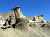
Starland County, Alberta
Encyclopedia
Starland County is a municipal district located in southern Alberta
Southern Alberta
Southern Alberta is a region located in the Canadian province of Alberta. As of the year 2004, the region's population was approximately 272,017. The primary cities are Lethbridge and Medicine Hat...
Canada
Canada
Canada is a North American country consisting of ten provinces and three territories. Located in the northern part of the continent, it extends from the Atlantic Ocean in the east to the Pacific Ocean in the west, and northward into the Arctic Ocean...
.
The municipality was incorporated in 1912, and established in the current boundaries in 1943, under the name Municipal District of Morrin No. 277. The name was changed the same year to Municipal District of Starland No. 277. Starland achieved county status in 1998.
Demographics
In 2006, Starland County had a population of 2,371 living in 748 dwellingsHouse
A house is a building or structure that has the ability to be occupied for dwelling by human beings or other creatures. The term house includes many kinds of different dwellings ranging from rudimentary huts of nomadic tribes to free standing individual structures...
, a 7.3% increase from 2001. The municipal district has a land area of 2557.7 km² (987.5 sq mi) and a population density
Population density
Population density is a measurement of population per unit area or unit volume. It is frequently applied to living organisms, and particularly to humans...
of 0.9 /km2.
Its population as of 2001 was 2,210.
Communities
The following communities are located in this municipal district:Towns
- Drumheller
Villages
- DeliaDelia, AlbertaDelia is a village in southern Alberta, located northeast of Drumheller. It is a small farming community 1 km off of Highway 9, located just North of the beautiful Handhills. It was named for Delia Davis, wife of Alvin L...
- MorrinMorrin, AlbertaMorrin is a village in central Alberta, Canada. It is located 26 km north of the town of Drumheller, along Highway 27 and the Railink Central Western railway....
(municipal seat) - MunsonMunson, AlbertaMunson is a village in central Alberta, Canada. It is located 13 km north of the town of Drumheller along Highway 9 and the Canadian National Railway tracks.-Demographics:...
Hamlets
- CraigmyleCraigmyle, AlbertaCraigmyle is a hamlet in Alberta, Canada within Starland County. It is located between the towns of Delia and Hanna.- References :...
- MichichiMichichi, AlbertaMichichi is a hamlet in southern Alberta, Canada within Starland County. It is located south of Highway 9, approximately northeast of Calgary.- References :...
- Rowley
- RumseyRumsey, AlbertaRumsey is a hamlet in southern Alberta, Canada within Starland County. It is located west of Highway 56, approximately southeast of Red Deer.- References :...
– dissolved as village in 1995
External links
- Starland County - Official site