
Division No. 2, Alberta
Encyclopedia
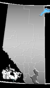
Division No. 2 is a census division
in Alberta
, Canada
. It is located in the south-central portion of southern Alberta
and includes the City of Lethbridge
.
, a 6.4% increase from 2001. The census division has a land area of 17659.92 km² (6,818.5 sq mi) and a population density
of 8.1 inhabitants per square kilometre.
Census division
Census division is an official term in Canada and the United States. The census divisions of Canada are second-level census geographic unit, below provinces and territories, and above "census subdivisions" and "dissemination areas". In provinces where they exist, the census division may correspond...
in Alberta
Alberta
Alberta is a province of Canada. It had an estimated population of 3.7 million in 2010 making it the most populous of Canada's three prairie provinces...
, Canada
Canada
Canada is a North American country consisting of ten provinces and three territories. Located in the northern part of the continent, it extends from the Atlantic Ocean in the east to the Pacific Ocean in the west, and northward into the Arctic Ocean...
. It is located in the south-central portion of southern Alberta
Southern Alberta
Southern Alberta is a region located in the Canadian province of Alberta. As of the year 2004, the region's population was approximately 272,017. The primary cities are Lethbridge and Medicine Hat...
and includes the City of Lethbridge
Lethbridge
Lethbridge is a city in the province of Alberta, Canada, and the largest city in southern Alberta. It is Alberta's fourth-largest city by population after Calgary, Edmonton and Red Deer, and the third-largest by area after Calgary and Edmonton. The nearby Canadian Rockies contribute to the city's...
.
Census subdivisions
The following census subdivisions (municipalities or municipal equivalents) are located within Alberta's Division No. 2.- Cities
- Lethbridge
- BrooksBrooks, AlbertaBrooks is a city in southeast Alberta, Canada surrounded by the County of Newell. It is located on Highway 1 and the Canadian Pacific Railway, approximately southeast of Calgary, and northwest of Medicine Hat. The city has an elevation of .- History :The area that is now Brooks was originally...
- Towns
- BassanoBassano, AlbertaBassano is a town in Alberta, Canada. It is located on the Trans-Canada Highway approximately east of Calgary and northwest of Medicine Hat. It is also on the main line of the Canadian Pacific Railway...
- CoaldaleCoaldale, AlbertaCoaldale is a town in southern Alberta, Canada, located east of Lethbridge, along the Crowsnest Highway.- Attractions :The main attractions are the Alberta Birds of Prey Centre, the Land o' Lakes Golf Course, and the Gem of the West Museum....
- Coalhurst
- Milk RiverMilk River, AlbertaMilk River is a town in the province of Alberta, Canada, located on and named after the Milk River, which flows immediately to its south. It is south of Lethbridge, and from the Canada-U.S. border. It is primarily a service centre for the many farms and cattle ranches which surround...
- Picture ButtePicture Butte, AlbertaPicture Butte is a town in southern Alberta, Canada. It is located north of the city of Lethbridge. It claims the title of "Livestock Feeding Capital of Canada."...
- RaymondRaymond, AlbertaRaymond is a town in Warner County, Alberta, Canada. It is located in southern Alberta south of Lethbridge on Highway 52. Raymond is known for its annual rodeo and its large Mormon population...
- Taber
- VauxhallVauxhall, AlbertaVauxhall is a town in southern Alberta, Canada. It is located in the Municipal District of Taber, in the prairie land between Bow River and Oldman River....
- Bassano
- Villages
- BarnwellBarnwell, AlbertaBarnwell is a village in southern Alberta, Canada. It is located west of Taber and east of Lethbridge along the Crowsnest Highway, in the Municipal District of Taber.-History:...
- BaronsBarons, AlbertaBarons is a village in southern Alberta, Canada. It is located north of Lethbridge along Highway 23.A scene in a Superman movie was filmed at Barons.- History :...
- CouttsCoutts, AlbertaCoutts is a village in Alberta and the location of one of the busiest Canada – US border crossings in western Canada. It connects Highway 4 to Interstate 15, an important trade route between Alberta, American states along I-15, and Mexico.In 2004, a joint border facility opened in Coutts-Sweet...
- DuchessDuchess, AlbertaDuchess is a village in southern Alberta, Canada, located north of Brooks, across from Trans-Canada Highway, in the County of Newell.The village was named for Duchess Louise Marguerite. It is mainly a ranching community.- Demographics :...
- NoblefordNobleford, AlbertaNobleford is a village in southern Alberta, Canada and serves primarily as bedroom community of Lethbridge. It is located 32 km north of the city of Lethbridge.- History :...
- RosemaryRosemary, AlbertaRosemary is a village in southern Alberta. It is located 30 km north-west of the city of Brooks and 14 km north of the Trans-Canada Highway. It is home to one school and several businesses.- Demographics :...
- StirlingStirling, AlbertaStirling is a village in the County of Warner No. 5, Alberta, Canada. The village is located on Highway 4, approximately southeast of Lethbridge and northwest of the United States-Canada border....
- TilleyTilley, AlbertaTilley is a village in southern Alberta, Canada. It is located within the County of Newell approximately 22 km southeast of the City of Brooks and 78 km northwest of the City of Medicine Hat.- Demographics :...
- WarnerWarner, AlbertaWarner is a village in southern Alberta, Canada. It is located in County of Warner, approximately 65 km south of the city of Lethbridge. Warner is a farming community. Warner is situated at the intersection of Highway 4 and Highway 36, about 38 km north of the Montana border and...
- Barnwell
- Municipal districts
- Lethbridge, County ofLethbridge County, AlbertaThe County of Lethbridge is a municipal district in southern Alberta. It is in Census Division 2 and part of the Lethbridge Census Agglomeration area.-Demographics:...
- Newell, County of
- Taber, M.D. ofTaber, Alberta (municipal district)The Municipal District of Taber is a municipal district in southern Alberta, Canada. It is located in Census Division 2.-Demographics:The population of the Municipal District of Taber according to its 2008 municipal census is 6,714....
- Warner No. 5, County ofWarner County No. 5, AlbertaThe County of Warner No. 5 is a municipal district in southern Alberta, Canada.It is located in Census Division 2, just north of the United States border. Warner was organised as a rural municipality since 1912, and established in the actual borders since 1954. The seat of the municipality is...
- Lethbridge, County of
Demographics
In 2006, Division No. 2 had a population of 142,429 living in 56,851 dwellingsHouse
A house is a building or structure that has the ability to be occupied for dwelling by human beings or other creatures. The term house includes many kinds of different dwellings ranging from rudimentary huts of nomadic tribes to free standing individual structures...
, a 6.4% increase from 2001. The census division has a land area of 17659.92 km² (6,818.5 sq mi) and a population density
Population density
Population density is a measurement of population per unit area or unit volume. It is frequently applied to living organisms, and particularly to humans...
of 8.1 inhabitants per square kilometre.