
.gif)
Barrow (Lake District)
Encyclopedia
Barrow is small fell
in the English
Lake District
in the county of Cumbria
which reaches a height of 455 metres (1,494 feet). It is situated in the quiet and picturesque Newlands Valley
just 4 kilometres south west of the town of Keswick
. Although modest in height, Barrow commands a fine all round view, with the vales of Keswick and Newlands being well seen. The name of the fell originates from the Anglo Saxon language
meaning a hill or long ridge.
. At the summit it turns due west across the depression of Barrow Door, diverted by the valley of Stonycroft Gill. Beyond the col
are Stile End and Outerside
. The valley of Coledale
lies to the north west and Newlands Beck forms the eastern boundary.
. The climb from Newlands starts at the hamlet of Stair and utilises an old mine road up Stonycroft Gill up to a height of 350 metres before veering back east to attain the summit. There are two paths from Braithwaite, one follows the northern ridge of the fell while the other approaches up the valley of Barrow Gill.
and siltstone
of the Kirkstile Formation, typical of the Skiddaw
group. A band of greywacke
sandstone
runs along the eastern flanks.
Like many of the fells in the Newlands Valley, Barrow has been extensively mined for lead
in the past, the spoil heaps are extensive and sweep down to the road at the eastern foot of the hill. The spoil is quite light in colour and is clearly visible from afar. Barrow mine first opened in the 17th century and eventually closed in 1888. The remaining spoil heaps are said to be in a state of continual slight movement and it is possible to hear a small rustle as the spoil slides down the hill. Another noteworthy topographical feature is the ravine
of Barrow Gill, which appears on the Braithwaite side of the fell, the Gill is deep and extensive and seems out of proportion to the small stream that it accommodates.
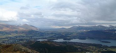 A small cairn
on grass marks the summit, with heather surrounding the top on all sides. The view takes in the surrounding higher North Western Fells
, together with the Helvellyn range
across Derwentwater and Skiddaw
standing above Keswick.
Fell
“Fell” is a word used to refer to mountains, or certain types of mountainous landscape, in Scandinavia, the Isle of Man, and parts of northern England.- Etymology :...
in the English
England
England is a country that is part of the United Kingdom. It shares land borders with Scotland to the north and Wales to the west; the Irish Sea is to the north west, the Celtic Sea to the south west, with the North Sea to the east and the English Channel to the south separating it from continental...
Lake District
Lake District
The Lake District, also commonly known as The Lakes or Lakeland, is a mountainous region in North West England. A popular holiday destination, it is famous not only for its lakes and its mountains but also for its associations with the early 19th century poetry and writings of William Wordsworth...
in the county of Cumbria
Cumbria
Cumbria , is a non-metropolitan county in North West England. The county and Cumbria County Council, its local authority, came into existence in 1974 after the passage of the Local Government Act 1972. Cumbria's largest settlement and county town is Carlisle. It consists of six districts, and in...
which reaches a height of 455 metres (1,494 feet). It is situated in the quiet and picturesque Newlands Valley
Newlands Valley
The Newlands Valley is in the Lake District National Park in Cumbria, England. It is regarded as one of the most picturesque and quiet valleys in the national park, even though it is situated very close to the popular tourist town of Keswick and the busy A66 road.The valley forms part of the civil...
just 4 kilometres south west of the town of Keswick
Keswick, Cumbria
Keswick is a market town and civil parish within the Borough of Allerdale in Cumbria, England. It had a population of 4,984, according to the 2001 census, and is situated just north of Derwent Water, and a short distance from Bassenthwaite Lake, both in the Lake District National Park...
. Although modest in height, Barrow commands a fine all round view, with the vales of Keswick and Newlands being well seen. The name of the fell originates from the Anglo Saxon language
Old English language
Old English or Anglo-Saxon is an early form of the English language that was spoken and written by the Anglo-Saxons and their descendants in parts of what are now England and southeastern Scotland between at least the mid-5th century and the mid-12th century...
meaning a hill or long ridge.
Topography
Barrow is a slender ridge climbing south west from BraithwaiteBraithwaite
Braithwaite is a village in the northern Lake District, in Cumbria, England. Historically within Cumberland, it lies just to the west of Keswick and to the east of the Grisedale Pike ridge, in the Borough of Allerdale. It forms part of the civil parish of Above Derwent.The eastern end of the...
. At the summit it turns due west across the depression of Barrow Door, diverted by the valley of Stonycroft Gill. Beyond the col
Mountain pass
A mountain pass is a route through a mountain range or over a ridge. If following the lowest possible route, a pass is locally the highest point on that route...
are Stile End and Outerside
Outerside
Outerside is a fell in the Lake District in Cumbria, England. It is located 6 kilometres west of Keswick in the north western part of the national park and is a smaller member of the Coledale group of fells with a height of 568 metres...
. The valley of Coledale
Coledale (Cumbria)
In Cumbria, England, Coledale is a valley in the northwestern region of the Lake District ~-Geography:Coledale is a narrow V shaped river valley running approximately north-east towards the Derwent Valley floodplain and the village of Braithwaite at the northeastern end...
lies to the north west and Newlands Beck forms the eastern boundary.
Ascents
Ascents of the fell are usually started from either the Newlands Valley or Braithwaite, both giving an enjoyable short ramble which can be combined with the adjoining higher fell of OutersideOuterside
Outerside is a fell in the Lake District in Cumbria, England. It is located 6 kilometres west of Keswick in the north western part of the national park and is a smaller member of the Coledale group of fells with a height of 568 metres...
. The climb from Newlands starts at the hamlet of Stair and utilises an old mine road up Stonycroft Gill up to a height of 350 metres before veering back east to attain the summit. There are two paths from Braithwaite, one follows the northern ridge of the fell while the other approaches up the valley of Barrow Gill.
Geology and mining
Barrow is composed of the laminated mudstoneMudstone
Mudstone is a fine grained sedimentary rock whose original constituents were clays or muds. Grain size is up to 0.0625 mm with individual grains too small to be distinguished without a microscope. With increased pressure over time the platey clay minerals may become aligned, with the...
and siltstone
Siltstone
Siltstone is a sedimentary rock which has a grain size in the silt range, finer than sandstone and coarser than claystones.- Description :As its name implies, it is primarily composed of silt sized particles, defined as grains 1/16 - 1/256 mm or 4 to 8 on the Krumbein phi scale...
of the Kirkstile Formation, typical of the Skiddaw
Skiddaw
Skiddaw is a mountain in the Lake District National Park in England. With a summit at 931 m above sea level it is the fourth highest mountain in England. It lies just north of the town of Keswick, Cumbria, and dominates the skyline in this part of the northern lakes...
group. A band of greywacke
Greywacke
Greywacke or Graywacke is a variety of sandstone generally characterized by its hardness, dark color, and poorly sorted angular grains of quartz, feldspar, and small rock fragments or lithic fragments set in a compact, clay-fine matrix. It is a texturally immature sedimentary rock generally found...
sandstone
Sandstone
Sandstone is a sedimentary rock composed mainly of sand-sized minerals or rock grains.Most sandstone is composed of quartz and/or feldspar because these are the most common minerals in the Earth's crust. Like sand, sandstone may be any colour, but the most common colours are tan, brown, yellow,...
runs along the eastern flanks.
Like many of the fells in the Newlands Valley, Barrow has been extensively mined for lead
Lead
Lead is a main-group element in the carbon group with the symbol Pb and atomic number 82. Lead is a soft, malleable poor metal. It is also counted as one of the heavy metals. Metallic lead has a bluish-white color after being freshly cut, but it soon tarnishes to a dull grayish color when exposed...
in the past, the spoil heaps are extensive and sweep down to the road at the eastern foot of the hill. The spoil is quite light in colour and is clearly visible from afar. Barrow mine first opened in the 17th century and eventually closed in 1888. The remaining spoil heaps are said to be in a state of continual slight movement and it is possible to hear a small rustle as the spoil slides down the hill. Another noteworthy topographical feature is the ravine
Ravine
A ravine is a landform narrower than a canyon and is often the product of streamcutting erosion. Ravines are typically classified as larger in scale than gullies, although smaller than valleys. A ravine is generally a fluvial slope landform of relatively steep sides, on the order of twenty to...
of Barrow Gill, which appears on the Braithwaite side of the fell, the Gill is deep and extensive and seems out of proportion to the small stream that it accommodates.
Summit and view
Cairn
Cairn is a term used mainly in the English-speaking world for a man-made pile of stones. It comes from the or . Cairns are found all over the world in uplands, on moorland, on mountaintops, near waterways and on sea cliffs, and also in barren desert and tundra areas...
on grass marks the summit, with heather surrounding the top on all sides. The view takes in the surrounding higher North Western Fells
North Western Fells
The North Western Fells are a group of hills in the English Lake District. Including such favourites as Catbells and Grisedale Pike, they occupy an oval area beneath the Buttermere and Borrowdale valley systems...
, together with the Helvellyn range
Helvellyn range
Helvellyn range is the name given to a part of the Eastern Fells in the English Lake District, fell being the local word for hill. The name comes from Helvellyn, the highest point of the group....
across Derwentwater and Skiddaw
Skiddaw
Skiddaw is a mountain in the Lake District National Park in England. With a summit at 931 m above sea level it is the fourth highest mountain in England. It lies just north of the town of Keswick, Cumbria, and dominates the skyline in this part of the northern lakes...
standing above Keswick.