
California State Route 128
Encyclopedia
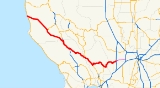
State Route 128 is a state highway
in the U.S. state
of California
, connecting the Mendocino
coast to the Central Valley through the state's Wine Country.
 Route 128 begins at Route 1
near the mouth of the Navarro River
at the Pacific Ocean
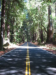
. The highway travels upriver through the coast redwood forests of Navarro River Redwoods State Park
and through the vineyards and apple orchards of the Anderson Valley
to Boonville
. Route 253
terminates into Route 128 at the south end of Boonville. Leaving Boonville, Route 128 climbs out of the Navarro River watershed and crosses the Yorkville Highlands before descending into the Russian River
watershed, arriving at Cloverdale
in the Alexander Valley
, where the highway joins U.S. Route 101 heading south. A few miles later, at Geyserville
, Route 128 separates from U.S. 101 and crosses Knights Valley on the way to Napa Valley, where it joins Route 29
at Calistoga
. After passing through the town of St. Helena
, Route 128 splits from Route 29 at Rutherford and climbs east over dry ridges above Lake Berryessa
to the Sacramento Valley
. In Winters
, the route's constructed portion ends at Interstate 505. By its legal definition, the route continues 14 mi (22.5 km) east to Route 113
at Davis
and Interstate 80, but this segment is currently not constructed.
The section of Route 128 through Navarro River Redwoods State Park is often closed in winter storms due to flooding. Two slower alternate routes are available: the Philo-Greenwood road connects Route 1 near Elk to Route 128 near Hendy Woods State Park
, a few miles north of Philo
; another alternate route is the Comptche-Ukiah Road, which intersects Route 1 just south of the town of Mendocino
and runs inland to Comptche
, and departs Comptche on Flynn Creek Road, intersecting Route 128 just up river from the seasonal flood gate closing the highway.
{| class=wikitable
|-
!County
!Location
!Postmile
!Exit
!Destinations
!Notes
|-
|rowspan=2|Mendocino
MEN 0.00-50.90
|
|0.00
|
|
|
|-
|Boonville
|29.58
|
|
|
|-
|rowspan=10|Sonoma
SON 0.00-24.76
|
| style="background:#dfd;"|
| style="background:#dfd;"|
| style="background:#dfd;"|North Cloverdale Boulevard (US 101 Bus. south, SR 128 Bus. east) – Cloverdale
| style="background:#dfd;"|West end of US 101 Bus. overlap
|-
|
| style="background:#dfd;"|L4.86
R53.40Indicates that the postmile represents the distance along US 101 rather than SR 128.
| style="background:#dfd;"|
| style="background:#dfd;"|
| style="background:#dfd;"|Interchange; east end of US 101 Bus. overlap; west end of US 101 overlap
|-
| colspan="5" style="text-align:center;"|West end of freeway on US 101
|-
|Cloverdale
|R51.62
|520
|Citrus Fair Drive
|
|-
|
|R50.43
|519
|South Cloverdale Boulevard (US 101 Bus. north, SR 128 Bus. west)
|
|-
|
|R49.05
|518
|Dutcher Creek Road – Stewarts Point
|
|-
|
|R47.85
|517
|Asti
|
|-
|rowspan=3|Geyserville
| colspan="4" style="text-align:center;"|East end of freeway on US 101
|- style="background:#dfd;"
|43.37
L4.86
|
|
|Interchange; east end of US 101 overlap
|-
|5.88
|
|.svg.png) Geyserville Avenue to US 101 south – San Francisco
Geyserville Avenue to US 101 south – San Francisco
|
|-
|rowspan=7|Napa
NAP 0.00-34.27
|
|2.66
|
|Tubbs Lane – Middletown
, Lakeport
|
|-
|rowspan=2|Calistoga
|3.62
|
|Petrified Forest Road – Santa Rosa
|
|- style="background:#dfd;"
|4.55
36.89Indicates that the postmile represents the distance along SR 29
rather than SR 128.
|
|, Downtown Calistoga
|West end of SR 29 overlap
|-
|Rutherford
| style="background:#dfd;"|24.60
4.56
| style="background:#dfd;"|
| style="background:#dfd;"|
| style="background:#dfd;"|East end of SR 29 overlap
|-
|
|7.37
|
|Silverado Trail – St. Helena, Calistoga
, Napa
|
|-
|
|11.28
|
|Chiles Pope Valley Road – Pope Valley
|
|-
|
|23.90
|
|
|
|-
|Solano
SOL 0.00-0.75
| colspan="5" style="text-align:center;"|No junctions
|-
|rowspan=3|Yolo
YOL 0.00-9.84
|Winters
|8.77
|
|Railroad Avenue – Madison
, Downtown Winters
|
|-
|
|9.84
|
|
|Interchange
|-
|
|9.84
|
|
|Continuation beyond I-505
|-
State highway
State highway, state road or state route can refer to one of three related concepts, two of them related to a state or provincial government in a country that is divided into states or provinces :#A...
in the U.S. state
U.S. state
A U.S. state is any one of the 50 federated states of the United States of America that share sovereignty with the federal government. Because of this shared sovereignty, an American is a citizen both of the federal entity and of his or her state of domicile. Four states use the official title of...
of California
California
California is a state located on the West Coast of the United States. It is by far the most populous U.S. state, and the third-largest by land area...
, connecting the Mendocino
Mendocino County, California
Mendocino County is a county located on the north coast of the U.S. state of California, north of the greater San Francisco Bay Area and west of the Central Valley. As of the 2010 census, the population was 87,841, up from 86,265 at the 2000 census...
coast to the Central Valley through the state's Wine Country.
Route description
California State Route 1
State Route 1 , more often called Highway 1, is a state highway that runs along much of the Pacific coast of the U.S. state of California. It is famous for running along some of the most beautiful coastlines in the world, leading to its designation as an All-American Road.Highway 1 does not run...
near the mouth of the Navarro River
Navarro River
The Navarro River is a river in Mendocino County, California. It flows northwest through the Coastal Range to the Pacific Ocean. Encompassing , its watershed includes the Anderson Valley, a well-known wine-growing region in Mendocino County. The main stem of the Navarro River begins less than ...
at the Pacific Ocean
Pacific Ocean
The Pacific Ocean is the largest of the Earth's oceanic divisions. It extends from the Arctic in the north to the Southern Ocean in the south, bounded by Asia and Australia in the west, and the Americas in the east.At 165.2 million square kilometres in area, this largest division of the World...
. The highway travels upriver through the coast redwood forests of Navarro River Redwoods State Park
Navarro River Redwoods State Park
Navarro River Redwoods State Park is a state park in Mendocino County, California consisting of of second-growth redwood forest in a narrow stretch long on both banks of the Navarro River, from the town of Navarro to the river's confluence with the Pacific Ocean.-Activities and facilities:The...
and through the vineyards and apple orchards of the Anderson Valley
Anderson Valley
Anderson Valley is a sparsely populated region in western Mendocino County in Northern California. Located approximately 100 miles north of San Francisco, the name "Anderson Valley" applies broadly to several rural, unincorporated communities in or near the alluvial terraces along Anderson Creek...
to Boonville
Boonville, California
Boonville is a census-designated place in Mendocino County, California. It is located southwest of Ukiah, at an elevation of 381 feet . The population was 1,035 at the 2010 census.-History:...
. Route 253
California State Route 253
State Route 253, also known as the Ukiah–Boonville Road, is a highway in Mendocino County, California. It runs from California State Route 128 near Boonville to U.S. Route 101 near Ukiah, connecting the Anderson Valley to the Ukiah Valley across the mountains of the Mendocino Range.-Route...
terminates into Route 128 at the south end of Boonville. Leaving Boonville, Route 128 climbs out of the Navarro River watershed and crosses the Yorkville Highlands before descending into the Russian River
Russian River (California)
The Russian River, a southward-flowing river, drains of Sonoma and Mendocino counties in Northern California. With an annual average discharge of approximately , it is the second largest river flowing through the nine county Greater San Francisco Bay Area with a mainstem 110 miles ...
watershed, arriving at Cloverdale
Cloverdale, California
Cloverdale is a city in Sonoma County, California, United States. The San Francisco and North Pacific Railroad reached Cloverdale in 1872. The Cloverdale Rancheria of Pomo Indians of California is headquartered here...
in the Alexander Valley
Alexander Valley
The Alexander Valley is a Californian American Viticultural Area just north of Healdsburg in Sonoma County. It is home to many wineries and vineyards, as well as the city of Cloverdale. It is the largest and most fully planted wine region in Sonoma. Highway 101 runs through the valley, and the...
, where the highway joins U.S. Route 101 heading south. A few miles later, at Geyserville
Geyserville, California
Geyserville is an unincorporated community and census-designated place in Sonoma County, California, USA. Located in the Wine Country, it is noted by tourists for its restaurants, bed and breakfast inns, and wineries...
, Route 128 separates from U.S. 101 and crosses Knights Valley on the way to Napa Valley, where it joins Route 29
California State Route 29
State Route 29 is a state highway in the U.S. state of California that travels in a north–south direction from State Route 20 in Upper Lake to Interstate 80 in Vallejo.-Route description:...
at Calistoga
Calistoga, California
Calistoga is a city in Napa County, California, United States. The population was 5,155 at the 2010 census.-Geography:According to the United States Census Bureau, the city has a total area of , 99.30% of it land and 0.70% of it water.-Climate:...
. After passing through the town of St. Helena
St. Helena, California
St. Helena is a city in Napa County, California, United States. It is part of the northern San Francisco Bay Area. The population was 5,814 at the 2010 census....
, Route 128 splits from Route 29 at Rutherford and climbs east over dry ridges above Lake Berryessa
Lake Berryessa
Lake Berryessa is the largest lake in Napa County, California. This reservoir is formed by the Monticello Dam, which provides water and hydroelectricity to the North Bay region of the San Francisco Bay Area....
to the Sacramento Valley
Sacramento Valley
The Sacramento Valley is the portion of the California Central Valley that lies to the north of the San Joaquin-Sacramento Delta in the U.S. state of California. It encompasses all or parts of ten counties.-Geography:...
. In Winters
Winters, California
Winters is a city in Yolo County, California. The population was 6,624 as of the 2010 census. It is part of the Sacramento–Arden-Arcade–Roseville Metropolitan Statistical Area. The city is near Lake Berryessa. It is noted as the one-time residence of cartoonist R...
, the route's constructed portion ends at Interstate 505. By its legal definition, the route continues 14 mi (22.5 km) east to Route 113
California State Route 113
State Route 113 is a north–south state highway in the U.S. state of California that runs from around west of Rio Vista at State Route 12 to State Route 99 south of Yuba City. It is an important connecting route between Interstate 80 and Interstate 5. Past the southern terminus are...
at Davis
Davis, California
Davis is a city in Yolo County, California, United States. It is part of the Sacramento–Arden-Arcade–Roseville Metropolitan Statistical Area...
and Interstate 80, but this segment is currently not constructed.
The section of Route 128 through Navarro River Redwoods State Park is often closed in winter storms due to flooding. Two slower alternate routes are available: the Philo-Greenwood road connects Route 1 near Elk to Route 128 near Hendy Woods State Park
Hendy Woods State Park
Hendy Woods State Park is a state park located in Mendocino County, California. The park contains two groves of old growth Coast Redwood: Big Hendy and Little Hendy . The Navarro River runs through the length of the park....
, a few miles north of Philo
Philo, California
Philo is a census-designated place in Mendocino County, California. It is located northwest of Boonville, at an elevation of 331 feet . The population was 349 at the 2010 census....
; another alternate route is the Comptche-Ukiah Road, which intersects Route 1 just south of the town of Mendocino
Mendocino, California
Mendocino is a census-designated place in Mendocino County, California, United States. Mendocino is located south of Fort Bragg, at an elevation of 154 feet...
and runs inland to Comptche
Comptche, California
Comptche is a census-designated place in Mendocino County, California, United States. It is located southeast of Fort Bragg, at an elevation of 187 feet . There is a KG-3 Primary school serving the town. The population was 159 at the 2010 census....
, and departs Comptche on Flynn Creek Road, intersecting Route 128 just up river from the seasonal flood gate closing the highway.
Major intersections
- Note: Except where prefixed with a letter, postmiles were measured in 1964, based on the alignment as it existed at that time, and do not necessarily reflect current mileage. The numbers reset at county lines; the start and end postmiles in each county are given in the county column.
{| class=wikitable
|-
!County
!Location
!Postmile
!Exit
Exit number
An exit number is a number assigned to a road junction, usually an exit from a freeway. It is usually marked on the same sign as the destinations of the exit, as well as a sign in the gore....
!Destinations
!Notes
|-
|rowspan=2|Mendocino
Mendocino County, California
Mendocino County is a county located on the north coast of the U.S. state of California, north of the greater San Francisco Bay Area and west of the Central Valley. As of the 2010 census, the population was 87,841, up from 86,265 at the 2000 census...
MEN 0.00-50.90
|
|0.00
|
|
|
|-
|Boonville
Boonville, California
Boonville is a census-designated place in Mendocino County, California. It is located southwest of Ukiah, at an elevation of 381 feet . The population was 1,035 at the 2010 census.-History:...
|29.58
|
|
|
|-
|rowspan=10|Sonoma
Sonoma County, California
Sonoma County, located on the northern coast of the U.S. state of California, is the largest and northernmost of the nine San Francisco Bay Area counties. Its population at the 2010 census was 483,878. Its largest city and county seat is Santa Rosa....
SON 0.00-24.76
|
| style="background:#dfd;"|
| style="background:#dfd;"|
| style="background:#dfd;"|North Cloverdale Boulevard (US 101 Bus. south, SR 128 Bus. east) – Cloverdale
Cloverdale, California
Cloverdale is a city in Sonoma County, California, United States. The San Francisco and North Pacific Railroad reached Cloverdale in 1872. The Cloverdale Rancheria of Pomo Indians of California is headquartered here...
| style="background:#dfd;"|West end of US 101 Bus. overlap
|-
|
| style="background:#dfd;"|L4.86
R53.40Indicates that the postmile represents the distance along US 101 rather than SR 128.
| style="background:#dfd;"|
| style="background:#dfd;"|
| style="background:#dfd;"|Interchange; east end of US 101 Bus. overlap; west end of US 101 overlap
|-
| colspan="5" style="text-align:center;"|West end of freeway on US 101
|-
|Cloverdale
Cloverdale, California
Cloverdale is a city in Sonoma County, California, United States. The San Francisco and North Pacific Railroad reached Cloverdale in 1872. The Cloverdale Rancheria of Pomo Indians of California is headquartered here...
|R51.62
|520
|Citrus Fair Drive
|
|-
|
|R50.43
|519
|South Cloverdale Boulevard (US 101 Bus. north, SR 128 Bus. west)
|
|-
|
|R49.05
|518
|Dutcher Creek Road – Stewarts Point
Stewarts Point, California
Stewarts Point is an unincorporated community in Sonoma County, California, United States. Stewarts Point is located on the Pacific coast and California State Route 1 west of Healdsburg. Stewarts Point has a post office with ZIP code 95480, which was established in 1888...
|
|-
|
|R47.85
|517
|Asti
Asti, California
Asti is an unincorporated community in Sonoma County, California, USA. It is located near U.S. Route 101 in the Alexander Valley between Cloverdale and Healdsburg....
|
|-
|rowspan=3|Geyserville
Geyserville, California
Geyserville is an unincorporated community and census-designated place in Sonoma County, California, USA. Located in the Wine Country, it is noted by tourists for its restaurants, bed and breakfast inns, and wineries...
| colspan="4" style="text-align:center;"|East end of freeway on US 101
|- style="background:#dfd;"
|43.37
L4.86
|
|
|Interchange; east end of US 101 overlap
|-
|5.88
|
|
San Francisco, California
San Francisco , officially the City and County of San Francisco, is the financial, cultural, and transportation center of the San Francisco Bay Area, a region of 7.15 million people which includes San Jose and Oakland...
|
|-
|rowspan=7|Napa
Napa County, California
Napa County is a county located north of the San Francisco Bay Area in the U.S. state of California. It is coterminous with the Napa, California, Metropolitan Statistical Area. As of 2010 the population is 136,484. The county seat is Napa....
NAP 0.00-34.27
|
|2.66
|
|Tubbs Lane – Middletown
Middletown, California
Middletown is a census-designated place in Lake County, California, United States. Middletown is located south of Lower Lake, at an elevation of 1099 feet . The population was 1,323 at the 2010 census, up from 1,020 at the 2000 census...
, Lakeport
Lakeport, California
Lakeport is an incorporated city and county seat of Lake County, California. Lakeport is located on the west shore of Clear Lake, at an elevation of 1355 feet...
|
|-
|rowspan=2|Calistoga
Calistoga, California
Calistoga is a city in Napa County, California, United States. The population was 5,155 at the 2010 census.-Geography:According to the United States Census Bureau, the city has a total area of , 99.30% of it land and 0.70% of it water.-Climate:...
|3.62
|
|Petrified Forest Road – Santa Rosa
Santa Rosa, California
Santa Rosa is the county seat of Sonoma County, California, United States. The 2010 census reported a population of 167,815. Santa Rosa is the largest city in California's Wine Country and fifth largest city in the San Francisco Bay Area, after San Jose, San Francisco, Oakland, and Fremont and 26th...
|
|- style="background:#dfd;"
|4.55
36.89Indicates that the postmile represents the distance along SR 29
California State Route 29
State Route 29 is a state highway in the U.S. state of California that travels in a north–south direction from State Route 20 in Upper Lake to Interstate 80 in Vallejo.-Route description:...
rather than SR 128.
|
|, Downtown Calistoga
Calistoga, California
Calistoga is a city in Napa County, California, United States. The population was 5,155 at the 2010 census.-Geography:According to the United States Census Bureau, the city has a total area of , 99.30% of it land and 0.70% of it water.-Climate:...
|West end of SR 29 overlap
|-
|Rutherford
| style="background:#dfd;"|24.60
4.56
| style="background:#dfd;"|
| style="background:#dfd;"|
| style="background:#dfd;"|East end of SR 29 overlap
|-
|
|7.37
|
|Silverado Trail – St. Helena, Calistoga
Calistoga, California
Calistoga is a city in Napa County, California, United States. The population was 5,155 at the 2010 census.-Geography:According to the United States Census Bureau, the city has a total area of , 99.30% of it land and 0.70% of it water.-Climate:...
, Napa
Napa, California
-History:The name Napa was probably derived from the name given to a southern Nappan village whose people shared the area with elk, deer, grizzlies and cougars for many centuries, according to Napa historian Kami Santiago. At the time of the first recorded exploration into Napa Valley in 1823, the...
|
|-
|
|11.28
|
|Chiles Pope Valley Road – Pope Valley
Pope Valley, California
Pope Valley is an unincorporated community located in the small valley of the same name in northern Napa County, California. It is east of Calistoga, north of Angwin, and borders Lake Berryessa, the second largest man-made lake in California. The zip code for Pope Valley is 94567, and the area...
|
|-
|
|23.90
|
|
|
|-
|Solano
Solano County, California
Solano County is a county located in Bay-Delta region of the U.S. state of California, about halfway between San Francisco and Sacramento and is one of the nine San Francisco Bay Area counties. The county's population was reported by the U.S. Census to be 413,344 in 2010...
SOL 0.00-0.75
| colspan="5" style="text-align:center;"|No junctions
|-
|rowspan=3|Yolo
Yolo County, California
Yolo County is a county located in the northern part of the U.S. state of California, bordered by the other counties of Sacramento, Solano, Napa, Lake, Colusa, and Sutter. The city of Woodland is its county seat, though Davis is its largest city....
YOL 0.00-9.84
|Winters
Winters, California
Winters is a city in Yolo County, California. The population was 6,624 as of the 2010 census. It is part of the Sacramento–Arden-Arcade–Roseville Metropolitan Statistical Area. The city is near Lake Berryessa. It is noted as the one-time residence of cartoonist R...
|8.77
|
|Railroad Avenue – Madison
Madison, California
Madison is a census-designated place in Yolo County, California. Madison's ZIP Code is 95653 and its area code 530. It is located west of Woodland, at an elevation of 151 feet . The 2010 United States census reported Madison's population was 503.-History:The Cache Creek post office opened in...
, Downtown Winters
Winters, California
Winters is a city in Yolo County, California. The population was 6,624 as of the 2010 census. It is part of the Sacramento–Arden-Arcade–Roseville Metropolitan Statistical Area. The city is near Lake Berryessa. It is noted as the one-time residence of cartoonist R...
|
|-
|
|9.84
|
|
|Interchange
|-
|
|9.84
|
|
|Continuation beyond I-505
|-