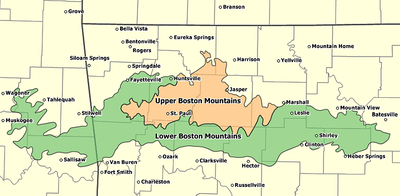
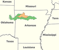
Boston Mountains
Encyclopedia
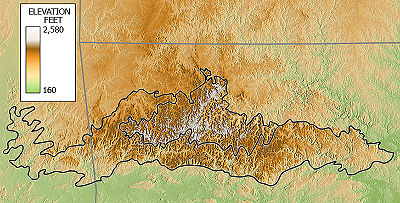
Dissected plateau
A dissected plateau is a plateau area that has been severely eroded so that the relief is sharp. Such an area may be referred to as mountainous, but dissected plateaus are distinguishable from orogenic mountain belts by the lack of folding, metamorphism, extensive faulting, or magmatic activity...
located in northern Arkansas
Arkansas
Arkansas is a state located in the southern region of the United States. Its name is an Algonquian name of the Quapaw Indians. Arkansas shares borders with six states , and its eastern border is largely defined by the Mississippi River...
and eastern Oklahoma
Oklahoma
Oklahoma is a state located in the South Central region of the United States of America. With an estimated 3,751,351 residents as of the 2010 census and a land area of 68,667 square miles , Oklahoma is the 28th most populous and 20th-largest state...
. The Oklahoma portion of the range is locally referred to as the Cookson Hills
Cookson Hills
The Cookson Hills are in the eastern part of Oklahoma. They are an extension of the Boston Mountains of Arkansas to the east and the southwestern margin of the Ozark Plateau. They lie generally between Stilwell, Oklahoma, Sallisaw, Oklahoma and Tahlequah, Oklahoma. The area became part of the...
. The rocks of the region are essentially little disturbed, flat-lying sedimentary layers of the Paleozoic
Paleozoic
The Paleozoic era is the earliest of three geologic eras of the Phanerozoic eon, spanning from roughly...
age. The highest ridges and peaks are capped by Pennsylvanian
Pennsylvanian
The Pennsylvanian is, in the ICS geologic timescale, the younger of two subperiods of the Carboniferous Period. It lasted from roughly . As with most other geochronologic units, the rock beds that define the Pennsylvanian are well identified, but the exact date of the start and end are uncertain...
sandstone
Sandstone
Sandstone is a sedimentary rock composed mainly of sand-sized minerals or rock grains.Most sandstone is composed of quartz and/or feldspar because these are the most common minerals in the Earth's crust. Like sand, sandstone may be any colour, but the most common colours are tan, brown, yellow,...
and shale
Shale
Shale is a fine-grained, clastic sedimentary rock composed of mud that is a mix of flakes of clay minerals and tiny fragments of other minerals, especially quartz and calcite. The ratio of clay to other minerals is variable. Shale is characterized by breaks along thin laminae or parallel layering...
. The deeply eroded valleys are cut into Mississippian limestone
Limestone
Limestone is a sedimentary rock composed largely of the minerals calcite and aragonite, which are different crystal forms of calcium carbonate . Many limestones are composed from skeletal fragments of marine organisms such as coral or foraminifera....
s and below that layer Ordovician
Ordovician
The Ordovician is a geologic period and system, the second of six of the Paleozoic Era, and covers the time between 488.3±1.7 to 443.7±1.5 million years ago . It follows the Cambrian Period and is followed by the Silurian Period...
dolomite
Dolomite
Dolomite is a carbonate mineral composed of calcium magnesium carbonate CaMg2. The term is also used to describe the sedimentary carbonate rock dolostone....
s.
The Boston Mountains form the southwestern part of the Ozark
The Ozarks
The Ozarks are a physiographic and geologic highland region of the central United States. It covers much of the southern half of Missouri and an extensive portion of northwestern and north central Arkansas...
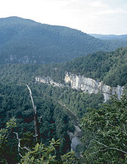
plateau where they are the highest and most rugged portion of the Ozarks. Summits can reach elevations of just over 2,560 feet with valleys 500 to 1,550 feet deep. Turner Ward Knob (TWK) is the highest named peak. Located in western Newton County, Arkansas
Newton County, Arkansas
Newton County is a county located in the U.S. state of Arkansas. As of 2010, the population is 8,330. The county seat is Jasper. Newton County is Arkansas's 46th county, formed on December 14, 1842, and named for Thomas W. Newton, an Arkansas Congressman...
, its elevation is 2,463 feet. Nearby, five unnamed peaks have elevations at or slightly above 2,560 feet. Two of these highest peaks are located 2.2 miles west of TWK, one being the location of the Buffalo Lookout fire tower. The other three highest peaks are located 4–5 miles SSW of TWK along Arkansas Highway 16.
The Boston Mountains are the source of rivers and streams that flow out from the mountains in all directions. Within a 3-mile radius of a point just west of the summits discussed above are located the sources of the White River
White River (Arkansas)
The White River is a 722-mile long river that flows through the U.S. states of Arkansas and Missouri.-Course:The source of the White River is in the Boston Mountains of northwest Arkansas, in the Ozark-St. Francis National Forest southeast of Fayetteville...
, the Buffalo River
Buffalo National River
The Buffalo River, located in northern Arkansas, was the first National River to be designated in the United States. The Buffalo River is slightly more than in length, with the lower flowing within the boundaries of an area managed by the National Park Service, where it is designated the '. The...
, the Kings River, War Eagle Creek, and Little Mulberry Creek. Other rivers and streams having their headwaters in the Boston Mountains include the Illinois River
Illinois River (Oklahoma)
The Illinois River is a tributary of the Arkansas River in the U.S. states of Arkansas and Oklahoma.It rises in the Ozark Mountains in the northwest corner of Arkansas, in Washington County southwest of Fayetteville, near the town of Hogeye. It flows west into northeast Oklahoma, then southwest...
, the Mulberry River
Mulberry River (Arkansas)
The Mulberry River is a tributary of the Arkansas River in northwestern Arkansas in the United States. Via the Arkansas River, it is part of the watershed of the Mississippi River. It has been designated a National Wild and Scenic River....
, Lee Creek
Lee Creek (Arkansas)
Lee Creek is a river in Arkansas and Oklahoma which starts near West Fork in Washington County, Arkansas and flows south to the Arkansas River passing through Crawford County, Arkansas and Sequoyah County, Oklahoma...
, Frog Bayou, Big Piney Creek, Illinois Bayou, and the Little Red River. To the south, the Arkansas River
Arkansas River
The Arkansas River is a major tributary of the Mississippi River. The Arkansas generally flows to the east and southeast as it traverses the U.S. states of Colorado, Kansas, Oklahoma, and Arkansas. The river's initial basin starts in the Western United States in Colorado, specifically the Arkansas...
valley separates the Boston Mountains from the Ouachita Mountains
Ouachita Mountains
The Ouachita Mountains are a mountain range in west central Arkansas and southeastern Oklahoma. The range's subterranean roots may extend as far as central Texas, or beyond it to the current location of the Marathon Uplift. Along with the Ozark Mountains, the Ouachita Mountains form the U.S...
.
In Arkansas the Boston Mountains are found in the following counties: Boone
Boone County, Arkansas
Boone County is a county located in the U.S. state of Arkansas. As of the 2010 census, the population was 36,903. The county seat is Harrison. Boone County is Arkansas's 62nd county, formed on April 9, 1869. Boone County is part of the Harrison Micropolitan Statistical Area.-History:Boone County...
, Carroll, Cleburne, Conway, Crawford, Franklin, Independence, Johnson, Madison
Madison County, Arkansas
Madison County is a county located in the U.S. state of Arkansas. As of 2010, the population was 15,717. The county seat is Huntsville. The county was formed on September 30, 1836, and named for James Madison, President of the United States...
, Newton
Newton County, Arkansas
Newton County is a county located in the U.S. state of Arkansas. As of 2010, the population is 8,330. The county seat is Jasper. Newton County is Arkansas's 46th county, formed on December 14, 1842, and named for Thomas W. Newton, an Arkansas Congressman...
, Pope, Searcy, Stone, Van Buren, and Washington
Washington County, Arkansas
Washington County is a county located in the northwest part of the U.S. state of Arkansas. As of 2010, the population was 203,065. The county seat is Fayetteville. Washington County is Arkansas's 17th county, formed on October 17, 1828, and named for George Washington, the first President of the...
.
In Oklahoma the Boston Mountains are found in these counties: Adair
Adair County, Oklahoma
Adair County is a county located in the U.S. state of Oklahoma. As of 2000, the population was 22,638. Its county seat is Stilwell. Adair County was named after the Adair family of the Cherokee tribe.-History:...
, Cherokee
Cherokee County, Oklahoma
Cherokee County is a county located in the U.S. state of Oklahoma. As of 2000, the population was 42,521. Its county seat is Tahlequah.Cherokee County was established in 1907.-Geography:...
, Muskogee
Muskogee County, Oklahoma
Muskogee County is a county located in the U.S. state of Oklahoma. As of 2010, the population was 70,990. Its county seat is Muskogee.-Government:...
, Sequoyah
Sequoyah County, Oklahoma
Sequoyah County is a county located in the U.S. state of Oklahoma. It is part of the Fort Smith, Arkansas-Oklahoma Metropolitan Statistical Area. As of 2000, the population was 38,972. Its county seat is Sallisaw.-History:...
, and Wagoner
Wagoner County, Oklahoma
Wagoner County is a county located in the U.S. state of Oklahoma. As of 2010, the population was 73,085. Its county seat is Wagoner.-Early History:The area of Wagoner County was settled by the Creek after their forced removal in Alabama in the 1820's...
.
[NAD83 geographic coordinates for TWK are N35.8631°, W093.4544°. Coordinates for the 5 unnamed highest peaks are N35.8637°, W093.4931°; N35.8607°, W093.4935°; N35.8151°, W093.4968°; N35.8126°, W093.4984°; and N35.7990°, W093.5005°]
Geology and physiography
The Boston Mountains are a physiographic sectionPhysiographic regions of the world
The physiographic regions of the world are a means of defining the Earth's landforms into distinct regions based upon classic 1916 three-tiered approach defining divisions, provinces, and sections...
of the larger Ozark Plateaus
The Ozarks
The Ozarks are a physiographic and geologic highland region of the central United States. It covers much of the southern half of Missouri and an extensive portion of northwestern and north central Arkansas...
province, which in turn is part of the larger Interior Highlands
U.S. Interior Highlands
The U.S. Interior Highlands is a mountainous region spanning eastern Oklahoma, western and northern Arkansas, southern Missouri, and the extreme southeast corner of Kansas. The name is designated by the United States Geological Survey to refer to the combined mountainous region of the Ozarks and...
physiographic division.
The area is underlain by Pennsylvanian sandstone, shale, and siltstone, where some folding and faulting has occurred. The sandstone beds become thinner, but more shaly in the west as the mountains decline in elevation.
External links