

Adair County, Oklahoma
Encyclopedia
Adair County is a county located in the U.S. state
of Oklahoma
. As of 2000, the population was 22,638. Its county seat
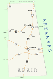
is Stilwell
. Adair County was named after the Adair
family of the Cherokee
tribe.
. There was a decade-long struggle over what town would become the county seat between Stilwell
and Westville
.
During the Great Depression and World War II, strawberries became a major crop in Adair County. In 1948, the first Stilwell Strawberry Festival was organized. The 2002 festival saw some 40,000 people in attendance.
The 1910 census counted 10,535 residents. By 1990, it was up to 18,421.
, the county has a total area of 577 square miles (1,494.4 km²), most of it land (576 square miles or 1,491 km²) and 1 square miles (2.6 km²) or 0.24 percent of it water.
The county is part of the Ozark plateau uplift, the tree-covered foothills of the Boston Mountains. North and central Adair County are drained by the Illinois River and three creeks. Two more creeks lie near Stilwell
.
of 2010, Adair County had a small population relative to its surrounding counties, with only 21,038 people, almost half of them (43.3 percent) Native American
. The remainder of the population was 43 percent white
, 10.5 percent of more than one race, and 5.3 percent Hispanic
or Latino
. Less than 1 percent of the population was either Black
or African American
, Asian
, or Pacific Islander
, and 2.3 percent were identified as other
.
The median age of the population was 36.2 years and two-thirds of the county's population were either under the age of 18 (28 percent) or between the ages of 25 to 44 (24.8 percent). Of the remaining population, 25.9 percent were ages 45 to 64, 12.9 percent were 65 years of age or older, and 13.2 percent were ages 18 to 24. For every 100 females there were 100.1 males. For every 100 females age 18 and over, there were 98.3 males.
There were a total of 8,156 households and 5,982 families in the county in 2010. There were 9,142 housing units. Of the 8,156 households, 31.4 percent included children under the age of 18 and slightly more than half (52.7 percent) included married couples
living together. 26.7 percent were non-family, 14.2 percent had a female householder with no husband present, and 26.8 percent contained a single individual of 65 years of age or older. The average household size was 2.77 and the average family size was 3.25.
The median income for a household in the county was $27,258, and the median income for a family was $32,930. Males had a median income of $28,370 versus $23,384 for females. The per capita income
for the county was $13,560. About 25.3 percent of families and 27.8 percent of the population were below the poverty line, including 36.8 percent of those under age 18 and 18.7 percent of those age 65 or over.
:
U.S. state
A U.S. state is any one of the 50 federated states of the United States of America that share sovereignty with the federal government. Because of this shared sovereignty, an American is a citizen both of the federal entity and of his or her state of domicile. Four states use the official title of...
of Oklahoma
Oklahoma
Oklahoma is a state located in the South Central region of the United States of America. With an estimated 3,751,351 residents as of the 2010 census and a land area of 68,667 square miles , Oklahoma is the 28th most populous and 20th-largest state...
. As of 2000, the population was 22,638. Its county seat
County seat
A county seat is an administrative center, or seat of government, for a county or civil parish. The term is primarily used in the United States....
is Stilwell
Stilwell, Oklahoma
Stilwell is a town in Adair County, Oklahoma, United States. The population was 3,276 at the 2000 census. It is the county seat of Adair County...
. Adair County was named after the Adair
William Penn Adair
William Penn Adair was a Cherokee leader and Confederate colonel.-Background:William Penn Adair was born on April 15, 1830 in the old Cherokee Nation in New Echota, Georgia. His parents were George Washington Adair and Martha Adair. He attended Cherokee schools in Indian Territory, studying law....
family of the Cherokee
Cherokee
The Cherokee are a Native American people historically settled in the Southeastern United States . Linguistically, they are part of the Iroquoian language family...
tribe.
History
The county was created in 1906 from the Goingsnake and Flint districts of the Cherokee NationCherokee Nation
The Cherokee Nation is the largest of three Cherokee federally recognized tribes in the United States. It was established in the 20th century, and includes people descended from members of the old Cherokee Nation who relocated voluntarily from the Southeast to Indian Territory and Cherokees who...
. There was a decade-long struggle over what town would become the county seat between Stilwell
Stilwell, Oklahoma
Stilwell is a town in Adair County, Oklahoma, United States. The population was 3,276 at the 2000 census. It is the county seat of Adair County...
and Westville
Westville, Oklahoma
Westville is a town in Adair County, Oklahoma, United States. The population was 1,596 at the 2000 census.-Geography:Westville is located at ....
.
During the Great Depression and World War II, strawberries became a major crop in Adair County. In 1948, the first Stilwell Strawberry Festival was organized. The 2002 festival saw some 40,000 people in attendance.
The 1910 census counted 10,535 residents. By 1990, it was up to 18,421.
Geography
According to the U.S. Census BureauUnited States Census Bureau
The United States Census Bureau is the government agency that is responsible for the United States Census. It also gathers other national demographic and economic data...
, the county has a total area of 577 square miles (1,494.4 km²), most of it land (576 square miles or 1,491 km²) and 1 square miles (2.6 km²) or 0.24 percent of it water.
The county is part of the Ozark plateau uplift, the tree-covered foothills of the Boston Mountains. North and central Adair County are drained by the Illinois River and three creeks. Two more creeks lie near Stilwell
Stilwell, Oklahoma
Stilwell is a town in Adair County, Oklahoma, United States. The population was 3,276 at the 2000 census. It is the county seat of Adair County...
.
Major highways
-
 U.S. Highway 59
 -
 U.S. Highway 62
 -
 State Highway 51State Highway 51 (Oklahoma)State Highway 51, abbreviated to SH-51 or OK-51, is a major state highway in Oklahoma. It runs for 333 miles east–west across the state, running from the Texas state line to Arkansas. It is the third-longest state highway in the system.-Texas to I-35:SH-51 begins at the Texas line concurrent...
Adjacent counties
- Delaware CountyDelaware County, OklahomaDelaware County is a county located in the U.S. state of Oklahoma. As of 2000, the population was 37,077 and the newest population estimate is 45,000. Its county seat is Jay. The county was named for the Delaware Indians resettled in what was then Indian Territory in the 1830s. .Delaware County...
(north) - Benton County, ArkansasBenton County, ArkansasBenton County is a county located in the U.S. state of Arkansas. As of the 2000 census, the population was 153,406. The U.S. Census Bureau 2010 population is 221,339. The county seat is Bentonville. Benton County was formed on 30 September 1836 and was named after Thomas Hart Benton, a U.S...
(northeast) - Washington County, ArkansasWashington County, ArkansasWashington County is a county located in the northwest part of the U.S. state of Arkansas. As of 2010, the population was 203,065. The county seat is Fayetteville. Washington County is Arkansas's 17th county, formed on October 17, 1828, and named for George Washington, the first President of the...
(east) - Crawford County, Arkansas (southeast)
- Sequoyah CountySequoyah County, OklahomaSequoyah County is a county located in the U.S. state of Oklahoma. It is part of the Fort Smith, Arkansas-Oklahoma Metropolitan Statistical Area. As of 2000, the population was 38,972. Its county seat is Sallisaw.-History:...
(south) - Cherokee CountyCherokee County, OklahomaCherokee County is a county located in the U.S. state of Oklahoma. As of 2000, the population was 42,521. Its county seat is Tahlequah.Cherokee County was established in 1907.-Geography:...
(west)
Demographics
As of the censusCensus
A census is the procedure of systematically acquiring and recording information about the members of a given population. It is a regularly occurring and official count of a particular population. The term is used mostly in connection with national population and housing censuses; other common...
of 2010, Adair County had a small population relative to its surrounding counties, with only 21,038 people, almost half of them (43.3 percent) Native American
Race (United States Census)
Race and ethnicity in the United States Census, as defined by the Federal Office of Management and Budget and the United States Census Bureau, are self-identification data items in which residents choose the race or races with which they most closely identify, and indicate whether or not they are...
. The remainder of the population was 43 percent white
Race (United States Census)
Race and ethnicity in the United States Census, as defined by the Federal Office of Management and Budget and the United States Census Bureau, are self-identification data items in which residents choose the race or races with which they most closely identify, and indicate whether or not they are...
, 10.5 percent of more than one race, and 5.3 percent Hispanic
Race (United States Census)
Race and ethnicity in the United States Census, as defined by the Federal Office of Management and Budget and the United States Census Bureau, are self-identification data items in which residents choose the race or races with which they most closely identify, and indicate whether or not they are...
or Latino
Race (United States Census)
Race and ethnicity in the United States Census, as defined by the Federal Office of Management and Budget and the United States Census Bureau, are self-identification data items in which residents choose the race or races with which they most closely identify, and indicate whether or not they are...
. Less than 1 percent of the population was either Black
Race (United States Census)
Race and ethnicity in the United States Census, as defined by the Federal Office of Management and Budget and the United States Census Bureau, are self-identification data items in which residents choose the race or races with which they most closely identify, and indicate whether or not they are...
or African American
Race (United States Census)
Race and ethnicity in the United States Census, as defined by the Federal Office of Management and Budget and the United States Census Bureau, are self-identification data items in which residents choose the race or races with which they most closely identify, and indicate whether or not they are...
, Asian
Race (United States Census)
Race and ethnicity in the United States Census, as defined by the Federal Office of Management and Budget and the United States Census Bureau, are self-identification data items in which residents choose the race or races with which they most closely identify, and indicate whether or not they are...
, or Pacific Islander
Race (United States Census)
Race and ethnicity in the United States Census, as defined by the Federal Office of Management and Budget and the United States Census Bureau, are self-identification data items in which residents choose the race or races with which they most closely identify, and indicate whether or not they are...
, and 2.3 percent were identified as other
Race (United States Census)
Race and ethnicity in the United States Census, as defined by the Federal Office of Management and Budget and the United States Census Bureau, are self-identification data items in which residents choose the race or races with which they most closely identify, and indicate whether or not they are...
.
The median age of the population was 36.2 years and two-thirds of the county's population were either under the age of 18 (28 percent) or between the ages of 25 to 44 (24.8 percent). Of the remaining population, 25.9 percent were ages 45 to 64, 12.9 percent were 65 years of age or older, and 13.2 percent were ages 18 to 24. For every 100 females there were 100.1 males. For every 100 females age 18 and over, there were 98.3 males.
There were a total of 8,156 households and 5,982 families in the county in 2010. There were 9,142 housing units. Of the 8,156 households, 31.4 percent included children under the age of 18 and slightly more than half (52.7 percent) included married couples
Marriage
Marriage is a social union or legal contract between people that creates kinship. It is an institution in which interpersonal relationships, usually intimate and sexual, are acknowledged in a variety of ways, depending on the culture or subculture in which it is found...
living together. 26.7 percent were non-family, 14.2 percent had a female householder with no husband present, and 26.8 percent contained a single individual of 65 years of age or older. The average household size was 2.77 and the average family size was 3.25.
The median income for a household in the county was $27,258, and the median income for a family was $32,930. Males had a median income of $28,370 versus $23,384 for females. The per capita income
Per capita income
Per capita income or income per person is a measure of mean income within an economic aggregate, such as a country or city. It is calculated by taking a measure of all sources of income in the aggregate and dividing it by the total population...
for the county was $13,560. About 25.3 percent of families and 27.8 percent of the population were below the poverty line, including 36.8 percent of those under age 18 and 18.7 percent of those age 65 or over.
Cities, towns and communities
|
Fairfield, Oklahoma Fairfield is a census-designated place in Adair County, Oklahoma, United States. The population was 367 at the 2000 census.-Geography:Fairfield is located at .... Elohim City, Oklahoma Elohim City is a private community in Adair County, Oklahoma founded by Robert G. Millar in 1973. Millar, a Canadian immigrant and charismatic religious leader, moved his followers to the site from their former location in Ellicott City, Maryland known as "The Camp", it was located on Route 144... Greasy, Oklahoma Greasy is a census-designated place in Adair County, Oklahoma, United States. The population was 387 at the 2000 census.-Geography:Greasy is located at .... Lyons Switch, Oklahoma Lyons Switch is a census-designated place in Adair County, Oklahoma, United States. The population was 227 at the 2000 census.-Geography:Lyons Switch is located at .... Maryetta, Oklahoma Maryetta is a census-designated place in Adair County, Oklahoma, United States. The population was 138 at the 2000 census.-Geography:Maryetta is located at .... Peavine, Oklahoma Peavine is a census-designated place in Adair County, Oklahoma, United States. The population was 358 at the 2000 census.-Geography:Peavine is located at .... Rocky Mountain, Oklahoma Rocky Mountain is a census-designated place in Adair County, Oklahoma, United States. The population was 448 at the 2000 census.-Geography:Rocky Mountain is located at .... |
Salem, Oklahoma Salem is a census-designated place in Adair County, Oklahoma, United States. The population was 89 at the 2000 census.-Geography:Salem is located at .... Stilwell, Oklahoma Stilwell is a town in Adair County, Oklahoma, United States. The population was 3,276 at the 2000 census. It is the county seat of Adair County... Watts, Oklahoma Watts is a town in Adair County, Oklahoma, United States. The population was 316 at the 2000 census.-Geography:Watts is located at .According to the United States Census Bureau, the town has a total area of , all of it land.... Watts Community, Oklahoma Watts Community is a census-designated place in Adair County, Oklahoma, United States. The population was 500 at the 2000 census.-Geography:Watts Community is located at .... West Peavine, Oklahoma West Peavine is a census-designated place in Adair County, Oklahoma, United States. The population was 225 at the 2000 census.-Geography:West Peavine is located at .... Westville, Oklahoma Westville is a town in Adair County, Oklahoma, United States. The population was 1,596 at the 2000 census.-Geography:Westville is located at .... Zion, Oklahoma Zion is a census-designated place in Adair County, Oklahoma, United States. The population was 48 at the 2000 census.-Geography:Zion is located at .... |
NRHP sites
The following sites in Adair County are listed on the National Register of Historic PlacesNational Register of Historic Places
The National Register of Historic Places is the United States government's official list of districts, sites, buildings, structures, and objects deemed worthy of preservation...
:
- Adair County Courthouse, Stilwell
- Buffington HotelBuffington HotelThe Buffington Hotel is an historic hotel in Westville, Oklahoma, United States. The brick building was built in about 1910 and features an arcade of round-arch windows on the East and South facades. The hotel was the premiere hotel in Westville when the town was railway stop. It was added to...
, Westville - Rev. Jesse Bushyhead Grave, Westville
- Golda's MillGolda's MillGolda's Mill was a historic water mill in Adair County, Oklahoma near Stilwell. It was built in about 1882 by Dr. Nicholas Bitting on the site of an older mill. It had an overshot water wheel which was 20 feet in diameter. The original wooden wheel was replaced by a steel wheel in 1908. The mill...
, Stilwell - Opera BlockOpera BlockThe Opera Block was a historic building in Westville, Oklahoma. The brick building was built in 1911-1912. It was used for multiple purposes throughout its existence, serving commercial, government and entertainment functions. For a time it served as the Westville City Hall. The second floor was...
, Westville - Beaver Gap, Stilwell