
Blue Knob State Park
Encyclopedia
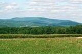
Blue Knob State Park is a 6128 acres (2,479.9 ha) Pennsylvania state park in Kimmel, Lincoln
, and Pavia townships in Bedford County
, Pennsylvania
, in the United States. The average annual snowfall at the park is about 12 feet (365.8 cm). The park is named for Blue Knob
, the second highest mountain in Pennsylvania at 3146 feet (958.9 m). It is the location of Blue Knob All Seasons Resort, the ski slope in Pennsylvania with the highest elevation. Blue Knob State Park is just off Interstate 99
on Pennsylvania Route 869
west of Pavia.
descent. They cleared and farmed the land soon after the American Revolution
. They also built several distilleries, a lumber mill and gristmill
.
The logging boom that swept over most of the mountains and forests of Pennsylvania drastically altered the landscape surrounding Blue Knob State Park. The old-growth forests of hemlock were clear cut. The timber was hauled away on train
s that climbed the steep hillsides. A railroad that followed Bobs Creek
used six switchbacks to ascend the mountain. Another railroad used five switchbacks to climb the hills near Wallacks Branch. These railroad grades are still used today to gain access to State Gamelands. The train tracks have since been removed and replaced with hiking trails.
The lumber industry abandoned the lands once all the salable timber had been harvested. They left behind a wasteland of dried out tree tops that were ignited by passing steam locomotive
s. The land was scarred by immense wild fires. The wildlife that had once thrived in the area was also gone due to over-hunting and deforestation.
The efforts of the National Park Service
are largely responsible for the reforestation of Blue Knob State Park. Blue Knob National Recreation Demonstration Area was opened by the park service in 1935. The park was built by the men of the Works Projects Administration and the young men of the Civilian Conservation Corps
. The WPA and CCC were established by President Franklin D. Roosevelt
during the Great Depression
to provide work for the unemployed. Ownership of the park was transferred to the Commonwealth of Pennsylvania on September 26, 1945 and Blue Knob State Park was officially opened.
Catskill Formation, consisting of sequences of sandstone, siltstone, and shale. The mountains in the park are capped by the Mississippian Burgoon Sandstone, which is underlain by the transitional Devonian
-Mississippian Rockwell Formation, consisting of crossbedded argillacious sandstone with some shale beds.
, snow boarding and tubing, a golf course
, trails for mountain biking
and cross-country skiing
. It is open year round. The lodge provides year round accommodations with tennis court
s and a swimming pool
.
weekend and closes Labor Day
weekend. The hours of operation are 11:00 am until 7:00 pm. Lifeguard
s are provided.
areas at Blue Knob State Park with over 200 picnic table
s. Mowery Hollow and Burnt House picnic areas are open year round. Willow Springs picnic area opens the weekend before Memorial Day and closes the day after Thanksgiving
.
.
A group of cabin
s, built and used by the CCC, is available for rent by large groups. The cabin area has a large dining hall and kitchen area and a showerhouse.
is permitted on about 5000 acres (2,023.4 ha) of Blue Knob State Park. The most common game species are turkey
, squirrels
and white-tailed deer
. The hunting of groundhog
s is prohibited. Hunters are expected to follow the rules and regulations of the Pennsylvania Game Commission
. The park is next to Pennsylvania State Game Land 26. There are parking lots and trails at Blue Knob State Park for those interested parking at the state park and hiking into the gamelands.
Mountain View Trail
This trail is 5 miles in length and one of the more difficult on the mountain. It is marked with a double red blaze and the trailhead can be found on the Tower Road just below the summit. The Mountain View Trail begins at about the 3,000 ft. contour and begins by looping around a gentle grade on the upper portion of the mountain's east shoulder. This part of the mountain is marked by stunted and wind deformed trees, mainly scrub oak and striped maple. Also large slabs of the conglomerate rocks that form this mountain may be seen strewn about on these upper slopes. This trail passes two lookouts, the Pavia Overlook and the Queen Overlook before descending into the Beaverdam Creek drainage and the lowest portion of this trail at the 2,000 ft. contour. The trail then traverses the east face of the mountain to the Willow Springs picnic area before it begins its steep ascent on the west face of the mountain and back to the trailhead.
Three Springs Trail
This trail is 2 miles in length and follows and old roadbed. The trail is wide and good for snowmobiles and horseback riding. This trail can be accessed from the Mountain View Trail at about the 3,050 ft. contour and generally runs downslope before it bisects the east face, and ends at the 2,500 ft. contour where it junctions once again with the Mountain View Trail. Along its length you can see how the trail got its name by the number of springs that are used for supplying water to the villages below the mountain.
Rock N' Ridge Trail
This trail begins at the 1,550 ft. contour just above the gated entrance to the park headquarters. It is 2.8 miles in length and marked by an inverted blue "T". The trail is located on the west side of the mountain and begins by following a ridge that abuts the main dome of the mountain. On this trail you may see mountain laurel which is the Pennsylvania State Flower. When the mountain laurel blooms in June it makes for a very scenic hike. The trail eventually junctions into the Sawmill trail at the 2,400 ft. contour, before this however, the trail has a turnoff which will descend down the Pavia Run drainage and end at the Mowry Hollow Picnic Area.
Sawmill Trail
The Sawmill Trail crosses the west face of the mountain and is 3 miles in length marked by yellow blazes. This is another wide trail that follows an old roadbed and is conducive to snowmobiles and mountain biking. The trailheads are located at either end of the trail off the Knob Road or on State Route 403 on Ickes Hill. If you begin on Ickes Hill, you will begin ascending the southwest buttress of the mountain to the Willow Springs Picinic Area at the 2,250 ft. contour. From there you will navigate shortly on the Mountain View Trail before you again pick up the Sawmill Trail. The trail moves across the hollows of the mountain at approximately the 2,400 ft. contour before it ends at that north end of Chappel Field and the trail head on the Knob Road. This hike takes you through rich hardwoods and passes over mountain seeps which drain from the upper slopes of the mountain, it is one of the easier hikes in the park.
Homestead Trail
This trail is a small loop at 1.8 miles in length and marked by orange blazes. The Homestead Trail may be gained by access off the Whysong Road or by a connector trail off the Sawmill Trail. The hike is on the lower portions of the mountain and only gains to the 2,100 ft. contour. The trail is easy and wide open and as its name suggests, marks the site of an old settlers house site. Hiking along this pathway affords good opportunities for viewing wildlife.
Chappell's Field Trail
The Chappell's Field Trail is accessible at points on the Knob Road and campground areas. The trail is located on one of the main ridges that are found on the west side of the mountain. On the top of this ridge, which is over 2,400 ft., Chapell's Field holds one of the best views in the park as it looks up at the main summit of Blue Knob and down on the valley below. The trail encircles the top of this ridge and is 2.5 miles in length, a loop marked by inverted orange "V" blazes.
Crist Ridge Trail
The 1.9 mile orange blazed trail connects to the Chappell's Field Trail at the 2,250 ft. contour and winds its way down the ridge ending on the Knob Road. This trail had large areas of blowdowns on it following the wind events in September 2004. Since then the trail has been cleared and is a good trail for mountain biking and cross country skiing. In the winter with the foliage down, views of Blue Knob Mountain can be seen through the trees.
Lost Turkey Trail
This is the longest and most difficult trail at 26 miles long. The trail begins on 3,034 foot Herman Point and is marked by red blazes. The trail crosses over both public and private lands as it eventually ends in neighboring Somerset County. To begin this hike you must proceed up the Tower Road and pass by the gated road which leads to Herman Point and the transmitter towers on its summit. Just behind the fenced in towers, you can see the trail which proceeds down the steep face of the mountain into the Rhodes Run drainage. From here the trail follows Ciana Run before crossing Hogback ridge, then beginning its steep ascent up Forks Ridge and the Allegheny Front beyond. Once on top of the Allegheny Plateau it winds its way through high elevation forests and mountain bogs. Proper footwear is recommended for this hike as it is steep in some areas and stream crossings are required along its length.
Connector Trails
There are several connector trails that make up the remaining mileage on Blue Knob's trails system. They are double blue blazed markings and vary in length and difficulty.
Bobs Creek is stocked
with trout
by the Pennsylvania Fish and Boat Commission
in co-operation with the Pavia Sportmen Club Inc. There is also a population of native brook trout
in Bobs Creek and its tributaries.
Lincoln Township, Bedford County, Pennsylvania
Lincoln Township is a township in Bedford County, Pennsylvania, United States. The population was 380 at the 2000 census.-Geography:According to the United States Census Bureau, the township has a total area of 16.2 square miles , all of it land.-Demographics:As of the census of 2000, there...
, and Pavia townships in Bedford County
Bedford County, Pennsylvania
Bedford County is a county located in the U.S. state of Pennsylvania. As of the 2010 census, the population was 49,762. The county seat is Bedford. It is part of the Altoona, Pennsylvania, Metropolitan Statistical Area.- History :...
, Pennsylvania
Pennsylvania
The Commonwealth of Pennsylvania is a U.S. state that is located in the Northeastern and Mid-Atlantic regions of the United States. The state borders Delaware and Maryland to the south, West Virginia to the southwest, Ohio to the west, New York and Ontario, Canada, to the north, and New Jersey to...
, in the United States. The average annual snowfall at the park is about 12 feet (365.8 cm). The park is named for Blue Knob
Blue Knob (Pennsylvania)
Blue Knob is a Pennsylvania summit with a broad dome that is the most northern of the 3,000 footers in the range of Allegheny Mountains. The mountain covers of Blue Knob State Park and contains approximately 18 miles of hiking trails and numerous overlooks. A ski area is located on the...
, the second highest mountain in Pennsylvania at 3146 feet (958.9 m). It is the location of Blue Knob All Seasons Resort, the ski slope in Pennsylvania with the highest elevation. Blue Knob State Park is just off Interstate 99
Interstate 99
Interstate 99 is an intrastate Interstate Highway located in central Pennsylvania in the United States. The southern terminus of the route is at exit 146 of the Pennsylvania Turnpike north of Bedford, where the road continues south as U.S. Route 220 . The northern terminus is at...
on Pennsylvania Route 869
Pennsylvania Route 869
Pennsylvania Route 869 is an east–west state route located in Western Pennsylvania. Its western terminus is at Ragers Hill Road just west of US 219 in St...
west of Pavia.
History
The earliest settlers to the Blue Knob area were of GermanGermany
Germany , officially the Federal Republic of Germany , is a federal parliamentary republic in Europe. The country consists of 16 states while the capital and largest city is Berlin. Germany covers an area of 357,021 km2 and has a largely temperate seasonal climate...
descent. They cleared and farmed the land soon after the American Revolution
American Revolution
The American Revolution was the political upheaval during the last half of the 18th century in which thirteen colonies in North America joined together to break free from the British Empire, combining to become the United States of America...
. They also built several distilleries, a lumber mill and gristmill
Gristmill
The terms gristmill or grist mill can refer either to a building in which grain is ground into flour, or to the grinding mechanism itself.- Early history :...
.
The logging boom that swept over most of the mountains and forests of Pennsylvania drastically altered the landscape surrounding Blue Knob State Park. The old-growth forests of hemlock were clear cut. The timber was hauled away on train
Train
A train is a connected series of vehicles for rail transport that move along a track to transport cargo or passengers from one place to another place. The track usually consists of two rails, but might also be a monorail or maglev guideway.Propulsion for the train is provided by a separate...
s that climbed the steep hillsides. A railroad that followed Bobs Creek
Bobs Creek
Bobs Creek is a tributary of Dunning Creek in south west/south central Pennsylvania in the United States. Via Dunning Creek, it is part of the watershed of the Raystown Branch Juniata River, flowing to the Juniata River, the Susquehanna River, and Chesapeake Bay...
used six switchbacks to ascend the mountain. Another railroad used five switchbacks to climb the hills near Wallacks Branch. These railroad grades are still used today to gain access to State Gamelands. The train tracks have since been removed and replaced with hiking trails.
The lumber industry abandoned the lands once all the salable timber had been harvested. They left behind a wasteland of dried out tree tops that were ignited by passing steam locomotive
Steam locomotive
A steam locomotive is a railway locomotive that produces its power through a steam engine. These locomotives are fueled by burning some combustible material, usually coal, wood or oil, to produce steam in a boiler, which drives the steam engine...
s. The land was scarred by immense wild fires. The wildlife that had once thrived in the area was also gone due to over-hunting and deforestation.
The efforts of the National Park Service
National Park Service
The National Park Service is the U.S. federal agency that manages all national parks, many national monuments, and other conservation and historical properties with various title designations...
are largely responsible for the reforestation of Blue Knob State Park. Blue Knob National Recreation Demonstration Area was opened by the park service in 1935. The park was built by the men of the Works Projects Administration and the young men of the Civilian Conservation Corps
Civilian Conservation Corps
The Civilian Conservation Corps was a public work relief program that operated from 1933 to 1942 in the United States for unemployed, unmarried men from relief families, ages 18–25. A part of the New Deal of President Franklin D...
. The WPA and CCC were established by President Franklin D. Roosevelt
Franklin D. Roosevelt
Franklin Delano Roosevelt , also known by his initials, FDR, was the 32nd President of the United States and a central figure in world events during the mid-20th century, leading the United States during a time of worldwide economic crisis and world war...
during the Great Depression
Great Depression
The Great Depression was a severe worldwide economic depression in the decade preceding World War II. The timing of the Great Depression varied across nations, but in most countries it started in about 1929 and lasted until the late 1930s or early 1940s...
to provide work for the unemployed. Ownership of the park was transferred to the Commonwealth of Pennsylvania on September 26, 1945 and Blue Knob State Park was officially opened.
Geology
The bedrock in the valleys of the park consists of the Upper DevonianDevonian
The Devonian is a geologic period and system of the Paleozoic Era spanning from the end of the Silurian Period, about 416.0 ± 2.8 Mya , to the beginning of the Carboniferous Period, about 359.2 ± 2.5 Mya...
Catskill Formation, consisting of sequences of sandstone, siltstone, and shale. The mountains in the park are capped by the Mississippian Burgoon Sandstone, which is underlain by the transitional Devonian
Devonian
The Devonian is a geologic period and system of the Paleozoic Era spanning from the end of the Silurian Period, about 416.0 ± 2.8 Mya , to the beginning of the Carboniferous Period, about 359.2 ± 2.5 Mya...
-Mississippian Rockwell Formation, consisting of crossbedded argillacious sandstone with some shale beds.
Recreation
The resort
Blue Knob All Seasons Resort is on Blue Knob the second highest mountain in Pennsylvania. The resort was opened on the site of a former military base. The resort includes 36 trails on slopes for skiingSkiing
Skiing is a recreational activity using skis as equipment for traveling over snow. Skis are used in conjunction with boots that connect to the ski with use of a binding....
, snow boarding and tubing, a golf course
Golf course
A golf course comprises a series of holes, each consisting of a teeing ground, fairway, rough and other hazards, and a green with a flagstick and cup, all designed for the game of golf. A standard round of golf consists of playing 18 holes, thus most golf courses have this number of holes...
, trails for mountain biking
Mountain biking
Mountain biking is a sport which consists of riding bicycles off-road, often over rough terrain, using specially adapted mountain bikes. Mountain bikes share similarities with other bikes, but incorporate features designed to enhance durability and performance in rough terrain.Mountain biking can...
and cross-country skiing
Cross-country skiing
Cross-country skiing is a winter sport in which participants propel themselves across snow-covered terrain using skis and poles...
. It is open year round. The lodge provides year round accommodations with tennis court
Tennis court
A tennis court is where the game of tennis is played. It is a firm rectangular surface with a low net stretched across the center. The same surface can be used to play both doubles and singles.-Dimensions:...
s and a swimming pool
Swimming pool
A swimming pool, swimming bath, wading pool, or simply a pool, is a container filled with water intended for swimming or water-based recreation. There are many standard sizes; the largest is the Olympic-size swimming pool...
.
Swimming
There is a swimming pool at the park that is separate from the pool at the resort. It opens Memorial DayMemorial Day
Memorial Day is a United States federal holiday observed on the last Monday of May. Formerly known as Decoration Day, it originated after the American Civil War to commemorate the fallen Union soldiers of the Civil War...
weekend and closes Labor Day
Labor Day
Labor Day is a United States federal holiday observed on the first Monday in September that celebrates the economic and social contributions of workers.-History:...
weekend. The hours of operation are 11:00 am until 7:00 pm. Lifeguard
Lifeguard
A lifeguard supervises the safety and rescue of swimmers, surfers, and other water sports participants such as in a swimming pool, water park, or beach. Lifeguards are strong swimmers and trained in first aid, certified in water rescue using a variety of aids and equipment depending on...
s are provided.
Picnics
There are three picnicPicnic
In contemporary usage, a picnic can be defined simply as a pleasure excursion at which a meal is eaten outdoors , ideally taking place in a beautiful landscape such as a park, beside a lake or with an interesting view and possibly at a public event such as before an open air theatre performance,...
areas at Blue Knob State Park with over 200 picnic table
Picnic table
A picnic table is a modified table with attached benches, designed for eating a meal outdoors .-Uses:...
s. Mowery Hollow and Burnt House picnic areas are open year round. Willow Springs picnic area opens the weekend before Memorial Day and closes the day after Thanksgiving
Thanksgiving
Thanksgiving Day is a holiday celebrated primarily in the United States and Canada. Thanksgiving is celebrated each year on the second Monday of October in Canada and on the fourth Thursday of November in the United States. In Canada, Thanksgiving falls on the same day as Columbus Day in the...
.
Camping
Blue Knob State Park has a campground with 45 sites, 25 of which have a connections to an electrical supply. 43 sites will accommodate tents or campers. Two of the sites are walk-in only. The campground has running water, a sanitary dump station, modern restrooms and a playgroundPlayground
A playground or play area is a place with a specific design for children be able to play there. It may be indoors but is typically outdoors...
.
A group of cabin
Log cabin
A log cabin is a house built from logs. It is a fairly simple type of log house. A distinction should be drawn between the traditional meanings of "log cabin" and "log house." Historically most "Log cabins" were a simple one- or 1½-story structures, somewhat impermanent, and less finished or less...
s, built and used by the CCC, is available for rent by large groups. The cabin area has a large dining hall and kitchen area and a showerhouse.
Hunting and fishing
HuntingHunting
Hunting is the practice of pursuing any living thing, usually wildlife, for food, recreation, or trade. In present-day use, the term refers to lawful hunting, as distinguished from poaching, which is the killing, trapping or capture of the hunted species contrary to applicable law...
is permitted on about 5000 acres (2,023.4 ha) of Blue Knob State Park. The most common game species are turkey
Wild Turkey
The Wild Turkey is native to North America and is the heaviest member of the Galliformes. It is the same species as the domestic turkey, which derives from the South Mexican subspecies of wild turkey .Adult wild turkeys have long reddish-yellow to grayish-green...
, squirrels
Eastern Gray Squirrel
The eastern gray squirrel is a tree squirrel in the genus Sciurus native to the eastern and midwestern United States, and to the southerly portions of the eastern provinces of Canada...
and white-tailed deer
White-tailed Deer
The white-tailed deer , also known as the Virginia deer or simply as the whitetail, is a medium-sized deer native to the United States , Canada, Mexico, Central America, and South America as far south as Peru...
. The hunting of groundhog
Groundhog
The groundhog , also known as a woodchuck, whistle-pig, or in some areas as a land-beaver, is a rodent of the family Sciuridae, belonging to the group of large ground squirrels known as marmots. Other marmots, such as the yellow-bellied and hoary marmots, live in rocky and mountainous areas, but...
s is prohibited. Hunters are expected to follow the rules and regulations of the Pennsylvania Game Commission
Pennsylvania Game Commission
The Pennsylvania Game Commission is the state agency responsible for wildlife conservation and management in Pennsylvania in the United States...
. The park is next to Pennsylvania State Game Land 26. There are parking lots and trails at Blue Knob State Park for those interested parking at the state park and hiking into the gamelands.
Trails
Blue Knob contains a vast network of hiking trails that range from easy walks to difficult and challenging day hikes. The total network of trails is approximately 18 miles in length. Most of these trails are multiple use for hiking, cross country skiing, mountain biking, horseback riding and snowmobiling. Below is a brief description of each trail that can be found on the mountain.Mountain View Trail
This trail is 5 miles in length and one of the more difficult on the mountain. It is marked with a double red blaze and the trailhead can be found on the Tower Road just below the summit. The Mountain View Trail begins at about the 3,000 ft. contour and begins by looping around a gentle grade on the upper portion of the mountain's east shoulder. This part of the mountain is marked by stunted and wind deformed trees, mainly scrub oak and striped maple. Also large slabs of the conglomerate rocks that form this mountain may be seen strewn about on these upper slopes. This trail passes two lookouts, the Pavia Overlook and the Queen Overlook before descending into the Beaverdam Creek drainage and the lowest portion of this trail at the 2,000 ft. contour. The trail then traverses the east face of the mountain to the Willow Springs picnic area before it begins its steep ascent on the west face of the mountain and back to the trailhead.
Three Springs Trail
This trail is 2 miles in length and follows and old roadbed. The trail is wide and good for snowmobiles and horseback riding. This trail can be accessed from the Mountain View Trail at about the 3,050 ft. contour and generally runs downslope before it bisects the east face, and ends at the 2,500 ft. contour where it junctions once again with the Mountain View Trail. Along its length you can see how the trail got its name by the number of springs that are used for supplying water to the villages below the mountain.
Rock N' Ridge Trail
This trail begins at the 1,550 ft. contour just above the gated entrance to the park headquarters. It is 2.8 miles in length and marked by an inverted blue "T". The trail is located on the west side of the mountain and begins by following a ridge that abuts the main dome of the mountain. On this trail you may see mountain laurel which is the Pennsylvania State Flower. When the mountain laurel blooms in June it makes for a very scenic hike. The trail eventually junctions into the Sawmill trail at the 2,400 ft. contour, before this however, the trail has a turnoff which will descend down the Pavia Run drainage and end at the Mowry Hollow Picnic Area.
Sawmill Trail
The Sawmill Trail crosses the west face of the mountain and is 3 miles in length marked by yellow blazes. This is another wide trail that follows an old roadbed and is conducive to snowmobiles and mountain biking. The trailheads are located at either end of the trail off the Knob Road or on State Route 403 on Ickes Hill. If you begin on Ickes Hill, you will begin ascending the southwest buttress of the mountain to the Willow Springs Picinic Area at the 2,250 ft. contour. From there you will navigate shortly on the Mountain View Trail before you again pick up the Sawmill Trail. The trail moves across the hollows of the mountain at approximately the 2,400 ft. contour before it ends at that north end of Chappel Field and the trail head on the Knob Road. This hike takes you through rich hardwoods and passes over mountain seeps which drain from the upper slopes of the mountain, it is one of the easier hikes in the park.
Homestead Trail
This trail is a small loop at 1.8 miles in length and marked by orange blazes. The Homestead Trail may be gained by access off the Whysong Road or by a connector trail off the Sawmill Trail. The hike is on the lower portions of the mountain and only gains to the 2,100 ft. contour. The trail is easy and wide open and as its name suggests, marks the site of an old settlers house site. Hiking along this pathway affords good opportunities for viewing wildlife.
Chappell's Field Trail
The Chappell's Field Trail is accessible at points on the Knob Road and campground areas. The trail is located on one of the main ridges that are found on the west side of the mountain. On the top of this ridge, which is over 2,400 ft., Chapell's Field holds one of the best views in the park as it looks up at the main summit of Blue Knob and down on the valley below. The trail encircles the top of this ridge and is 2.5 miles in length, a loop marked by inverted orange "V" blazes.
Crist Ridge Trail
The 1.9 mile orange blazed trail connects to the Chappell's Field Trail at the 2,250 ft. contour and winds its way down the ridge ending on the Knob Road. This trail had large areas of blowdowns on it following the wind events in September 2004. Since then the trail has been cleared and is a good trail for mountain biking and cross country skiing. In the winter with the foliage down, views of Blue Knob Mountain can be seen through the trees.
Lost Turkey Trail
This is the longest and most difficult trail at 26 miles long. The trail begins on 3,034 foot Herman Point and is marked by red blazes. The trail crosses over both public and private lands as it eventually ends in neighboring Somerset County. To begin this hike you must proceed up the Tower Road and pass by the gated road which leads to Herman Point and the transmitter towers on its summit. Just behind the fenced in towers, you can see the trail which proceeds down the steep face of the mountain into the Rhodes Run drainage. From here the trail follows Ciana Run before crossing Hogback ridge, then beginning its steep ascent up Forks Ridge and the Allegheny Front beyond. Once on top of the Allegheny Plateau it winds its way through high elevation forests and mountain bogs. Proper footwear is recommended for this hike as it is steep in some areas and stream crossings are required along its length.
Connector Trails
There are several connector trails that make up the remaining mileage on Blue Knob's trails system. They are double blue blazed markings and vary in length and difficulty.
Bobs Creek is stocked
Fish stocking
Fish stocking is the practice of raising fish in a hatchery and releasing them into a river, lake, or the ocean to supplement existing populations, or to create a population where none exists...
with trout
Trout
Trout is the name for a number of species of freshwater and saltwater fish belonging to the Salmoninae subfamily of the family Salmonidae. Salmon belong to the same family as trout. Most salmon species spend almost all their lives in salt water...
by the Pennsylvania Fish and Boat Commission
Pennsylvania Fish and Boat Commission
The Pennsylvania Fish and Boat Commission is the state agency responsible for the regulation of all fishing and boating in the Commonwealth of Pennsylvania...
in co-operation with the Pavia Sportmen Club Inc. There is also a population of native brook trout
Brook trout
The brook trout, Salvelinus fontinalis, is a species of fish in the salmon family of order Salmoniformes. In many parts of its range, it is known as the speckled trout or squaretail. A potamodromous population in Lake Superior are known as coaster trout or, simply, as coasters...
in Bobs Creek and its tributaries.
Nearby state parks
The following state parks are within 30 miles (48.3 km) of Blue Knob State Park:- Canoe Creek State ParkCanoe Creek State ParkCanoe Creek State Park is a Pennsylvania state park in Frankstown Township in Blair County, Pennsylvania. It is 12 miles east of Altoona, the nearest city. Canoe Lake, at , is the focus of recreation at the park and is open for fishing year round. Canoe Creek State Park is a half mile off U.S....
(Blair CountyBlair County, Pennsylvania-Significant Topographic Features:*Brush Mountain*Logan Valley*Morrison Cove*Tussey Mountain-Demographics:As of the census of 2000, there were 129,144 people, 51,518 households, and 34,877 families residing in the county. The population density was 246 people per square mile . There were 55,061...
) - Laurel Mountain State ParkLaurel Mountain State ParkLaurel Mountain State Park is a Pennsylvania state park in Ligonier Township, Westmoreland County and Jenner Township, Somerset County, Pennsylvania in the United States. This state park is a ski resort that closed for business in 2005. The ski assests of the park were purchased by Seven Springs...
(Westmoreland CountyWestmoreland County, Pennsylvania-Demographics:As of the census of 2000, there were 369,993 people, 149,813 households, and 104,569 families residing in the county. The population density was 361 people per square mile . There were 161,058 housing units at an average density of 157 per square mile...
) - Laurel Ridge State ParkLaurel Ridge State ParkLaurel Ridge State Park is a Pennsylvania state park that passes through Cambria, Fayette, Somerset, and Westmoreland counties, Pennsylvania in the United States. The park is home to the Laurel Highlands Hiking Trail that runs through the park from the Youghiogheny River at Ohiopyle to the...
(CambriaCambria County, PennsylvaniaCambria County is a county located in the U.S. state of Pennsylvania. It comprises the Johnstown, Pennsylvania, Metropolitan Statistical Area. As of 2010, the population was 143,679....
, FayetteFayette County, PennsylvaniaFayette County is a county located in the U.S. state of Pennsylvania. As of the2010 census, the population was 136,606. The county is part of the Pittsburgh Metropolitan Statistical Area....
, SomersetSomerset County, PennsylvaniaSomerset County is a county located in the state of Pennsylvania. As of 2010, the population was 77,742. Somerset County was created on April 17, 1795, from part of Bedford County and named for Somerset, United Kingdom. Its county seat is Somerset. It is part of the Johnstown, Pennsylvania,...
, and Westmoreland counties) - Prince Gallitzin State ParkPrince Gallitzin State ParkPrince Gallitzin State Park is a Pennsylvania state park in Chest and White Townships, Cambria County, Pennsylvania in the United States. The park is home to Glendale Lake a man-made lake. It has a large campground with campsites on the lake shore...
(Cambria County) - Shawnee State Park (Bedford CountyBedford County, PennsylvaniaBedford County is a county located in the U.S. state of Pennsylvania. As of the 2010 census, the population was 49,762. The county seat is Bedford. It is part of the Altoona, Pennsylvania, Metropolitan Statistical Area.- History :...
) - Trough Creek State ParkTrough Creek State ParkTrough Creek State Park is a Pennsylvania state park in Cass, Penn and Todd Townships, Huntingdon County, Pennsylvania in the United States. The majority of the park is in Todd Township along Pennsylvania Route 994, east of the unincorporated village of Entriken. Huntingdon is the nearest...
(Huntingdon CountyHuntingdon County, PennsylvaniaHuntingdon County is a county located in the U.S. state of Pennsylvania. In 2010, its population was 45,913.Huntingdon County was created on September 20, 1787, from part of Bedford County. Its county seat is Huntingdon.-Geography:According to the U.S...
) - Warriors Path State ParkWarriors Path State ParkWarriors Path State Park is a Pennsylvania state park on in Liberty Township, Bedford County, Pennsylvania, in the United States. It is named for the Great Indian Warpath that was used by the Iroquois in war raids with the Cherokee and other tribes. Warriors Path State Park is surrounded on three...
(Bedford County) - Yellow Creek State ParkYellow Creek State ParkYellow Creek State Park is a Pennsylvania state park on in Brush Valley and Cherryhill Townships, Indiana County, Pennsylvania in the United States. It is along Yellow Creek and Little Yellow Creek. The old Kittanning Path goes through the parkland. The park was established in 1963. An additional ...
(Indiana CountyIndiana County, Pennsylvania-Government and politics:As of November 2008, there are 58,077 registered voters in Indiana County .* Democratic: 26,653 * Republican: 24,159 * Other Parties: 7,265 -County commissioners:*Rodney Ruddock, Chairman, Republican...
)