
.gif)
Black Fell (Lake District)
Encyclopedia
Black Fell is a fell
in the English
Lake District
. It rises to the north of Tarn Hows
, between Coniston
and Hawkshead
.
, Langdale and Coniston. It occupies an area of around one mile by two, clad mainly in fell grass with many small outcrops of rock. Despite its modest altitude Alfred Wainwright
accorded Black Fell a chapter in his Pictorial Guide to the Lakeland Fells
, partly due to its excellence as a view point. It represents the perimeter of the Lakeland Fells proper in his opinion, the land to the south falling within his supplementary volume, The Outlying Fells of Lakeland. Later guidebook writers have also included Black Fell within their remit.
The fell has no obvious connecting ridges in the manner of higher mountains, but in fact has a pivotal position in this area of the district. To the west over Oxen Fell High Cross (518 ft) is Holme Fell
and an onward link to Wetherlam
and the Furness Fells
(Coniston Fells). To the south east a broad highland runs out between Windermere and Esthwaite Water
, terminating in Claife Heights. Finally southward runs the 7 mile ridge of Grizedale Forest
, capped by Carron Crag
and Top o'Selside
, Black Fell's topographical
parent.
Black Fell's northern boundary is formed by Elter Water and the River Brathay
. The broadleaved woodland of Brow Coppice stands above the village of Skelwith Bridge
in the valley. Beyond the eastern slopes is a mile of gently falling country, running through plantations to the head of Windermere. There are many tarns
within this landscape, most of them artificial. The largest are Blelham Tarn and the pools near the Drunken Duck (Inn) crossroads. On the western side is the A593 road from Coniston to Ambleside
, crossing the minor pass of Oxen Fell.
South of Black Fell is Tarn Hows, a picturesque work of landscape design initiated by James Marshall in the 1860s. This is one of the most popular destinations in the Lake District, the mixture of water, rock and arboretum
being finely contrived. Now owned by the National Trust
, the motor traffic is so great that a one-way system had to be initiated as early as the 1960s. Tarn Hows is maintained by a dam at the south west corner and circumnavigated by a broad, level path, providing access to all. Few of the millions of visitors stray onto the slopes of Black Fell, or even know the name of the hill which provides the backdrop to so many photographs.
The whole fell was once owned by the Marshall family of Monk Coniston, before passing via a Mrs Heelis (better known as Beatrix Potter
) to the National Trust, by whom it is held in perpetuity for the nation.
Although the lower slopes are wooded (except in the west), the top of the fell is open to the sky. In addition to the summit outcrop, somewhat optimistically titled Black Crag on maps, there are other tops at Great Cobble and Stephen How to the north, and Arnside and Tover Intakes to the south. A further feature on the southern flank of the fell is Iron Keld Plantation, through which the main access path to the summit climbs. There are some steeper areas, particularly at Pull Scar on the eastern side.
lapilli
-tuff
of the Lincomb Tarns Formation. Immediately to the east is the Brathay Fault, beyond which are sedimentary rock
s of the Windermere Group
.
 A bridleway runs across the fell from the summit of the A593 in the west to Knipe Fold in the east, locally known as the "mountain road". A further footpath
branches off northward to the vicinity of Skelwith Bridge, providing the best access to the summit. This bears an Ordnance Survey
triangulation column complete with a National Trust sign. 200 yards to the east a prominent cairn
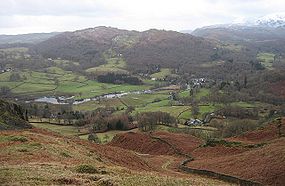
marks the best viewpoint for Windermere, whilst northerly views can be improved by the short march to Great Cobble. The panorama takes in both the high Coniston and Langdale Fells, and the lowlands and lakes to the south and west, a fine distillation of what Cumbria
has to offer.
, Tom Gill, Tarn Hows or Knipe Fold.
Fell
“Fell” is a word used to refer to mountains, or certain types of mountainous landscape, in Scandinavia, the Isle of Man, and parts of northern England.- Etymology :...
in the English
England
England is a country that is part of the United Kingdom. It shares land borders with Scotland to the north and Wales to the west; the Irish Sea is to the north west, the Celtic Sea to the south west, with the North Sea to the east and the English Channel to the south separating it from continental...
Lake District
Lake District
The Lake District, also commonly known as The Lakes or Lakeland, is a mountainous region in North West England. A popular holiday destination, it is famous not only for its lakes and its mountains but also for its associations with the early 19th century poetry and writings of William Wordsworth...
. It rises to the north of Tarn Hows
Tarn Hows
Tarn Hows is an area of the Lake District National Park, containing a picturesque tarn, approximately northeast of Coniston and about northwest of Hawkshead...
, between Coniston
Coniston, Cumbria
Coniston is a village and civil parish in the Furness region of Cumbria, England. It is located in the southern part of the Lake District National Park, between Coniston Water, the third longest lake in the Lake District, and Coniston Old Man; about north east of Barrow-in-Furness.-Geography and...
and Hawkshead
Hawkshead
Hawkshead is a village and civil parish in the Cumbria, England. It is one of the main tourist honeypots in the South Lakeland area, and is dependent on the local tourist trade...
.
Topography
Black Fell is the high point in the hilly area bounded by WindermereWindermere (lake)
Windermere is the largest natural lake in England. It is a ribbon lake formed in a glacial trough after the retreat of ice at the start of the current interglacial. It has been one of the country’s most popular places for holidays and summer homes since the arrival of the Kendal and Windermere...
, Langdale and Coniston. It occupies an area of around one mile by two, clad mainly in fell grass with many small outcrops of rock. Despite its modest altitude Alfred Wainwright
Alfred Wainwright
Alfred Wainwright MBE was a British fellwalker, guidebook author and illustrator. His seven-volume Pictorial Guide to the Lakeland Fells, published between 1955 and 1966 and consisting entirely of reproductions of his manuscript, has become the standard reference work to 214 of the fells of the...
accorded Black Fell a chapter in his Pictorial Guide to the Lakeland Fells
Pictorial Guide to the Lakeland Fells
A Pictorial Guide to the Lakeland Fells is a series of seven books by A. Wainwright, detailing the fells of the Lake District in northwest England...
, partly due to its excellence as a view point. It represents the perimeter of the Lakeland Fells proper in his opinion, the land to the south falling within his supplementary volume, The Outlying Fells of Lakeland. Later guidebook writers have also included Black Fell within their remit.
The fell has no obvious connecting ridges in the manner of higher mountains, but in fact has a pivotal position in this area of the district. To the west over Oxen Fell High Cross (518 ft) is Holme Fell
Holme Fell
Holme Fell or Holm Fell is a fell in the Lake District in Cumbria, England. It is located between Coniston Water and Little Langdale, almost isolated from the neighbouring Coniston Fells by Yewdale Beck.-Topography:...
and an onward link to Wetherlam
Wetherlam
Wetherlam is a mountain in the English Lake District. It is the most northerly of the Coniston Fells, the range of fells to the north-west of Coniston village; its north-east slopes descend to Little Langdale.-Topography:...
and the Furness Fells
Furness Fells
The Furness Fells are those hills and mountains in the Furness region of Cumbria, England. Historically part of Lancashire, the Furness Fells or High Furness is the name given to the upland part of Furness, that is, that part of Furness lying north of the line between Ulverston and Ireleth...
(Coniston Fells). To the south east a broad highland runs out between Windermere and Esthwaite Water
Esthwaite Water
Esthwaite Water is one of the smaller and lesser known lakes in the Lake District national park in northern England. It is situated between the much larger lakes of Windermere and Coniston Water, in the traditional county of Lancashire; since 1974 in the administrative county of Cumbria...
, terminating in Claife Heights. Finally southward runs the 7 mile ridge of Grizedale Forest
Grizedale Forest
Grizedale Forest is a 24.47 km² area of woodland in the Lake District of North West England, located to the east of Coniston Water and to the south of Hawkshead. It comprises a number of hills, small tarns and the settlements of Grizedale and Satterthwaite...
, capped by Carron Crag
Carron Crag
Carron Crag is a small fell in Grizedale Forest in the English Lake District with a height of 314 metres. Adjacent to the trig point is a large panopticon sculpture, one of over 70 in the forest...
and Top o'Selside
Top o'Selside
Top o'Selside is a hill in the Lake District in Cumbria, England. At 335 m, it is the highest point of the group of hills situated between Coniston Water and Windermere. This group also includes the Wainwright of Black Fell and the summits of Black Brows and Rusland Heights...
, Black Fell's topographical
Topography
Topography is the study of Earth's surface shape and features or those ofplanets, moons, and asteroids...
parent.
Black Fell's northern boundary is formed by Elter Water and the River Brathay
River Brathay
The Brathay is a river of north-west England. Its name comes from Old Norse and means broad river. It rises at a point 1289 feet above sea level near the Three Shire Stone at the highest point of Wrynose Pass in the Lake District...
. The broadleaved woodland of Brow Coppice stands above the village of Skelwith Bridge
Skelwith Bridge
Skelwith Bridge is a small village in the southern area of the Lake District in Cumbria, North West England. It is located around 3 miles south of Grasmere and is nearby the waterfalls of Skelwith Force and Colwith Force. The nearest lakes to the village are Elter Water to the north-west and...
in the valley. Beyond the eastern slopes is a mile of gently falling country, running through plantations to the head of Windermere. There are many tarns
Tarn (lake)
A tarn is a mountain lake or pool, formed in a cirque excavated by a glacier. A moraine may form a natural dam below a tarn. A corrie may be called a cirque.The word is derived from the Old Norse word tjörn meaning pond...
within this landscape, most of them artificial. The largest are Blelham Tarn and the pools near the Drunken Duck (Inn) crossroads. On the western side is the A593 road from Coniston to Ambleside
Ambleside
Ambleside is a town in Cumbria, in North West England.Historically within the county of Westmorland, it is situated at the head of Windermere, England's largest lake...
, crossing the minor pass of Oxen Fell.
South of Black Fell is Tarn Hows, a picturesque work of landscape design initiated by James Marshall in the 1860s. This is one of the most popular destinations in the Lake District, the mixture of water, rock and arboretum
Arboretum
An arboretum in a narrow sense is a collection of trees only. Related collections include a fruticetum , and a viticetum, a collection of vines. More commonly, today, an arboretum is a botanical garden containing living collections of woody plants intended at least partly for scientific study...
being finely contrived. Now owned by the National Trust
National Trust for Places of Historic Interest or Natural Beauty
The National Trust for Places of Historic Interest or Natural Beauty, usually known as the National Trust, is a conservation organisation in England, Wales and Northern Ireland...
, the motor traffic is so great that a one-way system had to be initiated as early as the 1960s. Tarn Hows is maintained by a dam at the south west corner and circumnavigated by a broad, level path, providing access to all. Few of the millions of visitors stray onto the slopes of Black Fell, or even know the name of the hill which provides the backdrop to so many photographs.
The whole fell was once owned by the Marshall family of Monk Coniston, before passing via a Mrs Heelis (better known as Beatrix Potter
Beatrix Potter
Helen Beatrix Potter was an English author, illustrator, natural scientist and conservationist best known for her imaginative children’s books featuring animals such as those in The Tale of Peter Rabbit which celebrated the British landscape and country life.Born into a privileged Unitarian...
) to the National Trust, by whom it is held in perpetuity for the nation.
Although the lower slopes are wooded (except in the west), the top of the fell is open to the sky. In addition to the summit outcrop, somewhat optimistically titled Black Crag on maps, there are other tops at Great Cobble and Stephen How to the north, and Arnside and Tover Intakes to the south. A further feature on the southern flank of the fell is Iron Keld Plantation, through which the main access path to the summit climbs. There are some steeper areas, particularly at Pull Scar on the eastern side.
Geology
The fell is composed of the daciticDacite
Dacite is an igneous, volcanic rock. It has an aphanitic to porphyritic texture and is intermediate in composition between andesite and rhyolite. The relative proportions of feldspars and quartz in dacite, and in many other volcanic rocks, are illustrated in the QAPF diagram...
lapilli
Lapilli
Lapilli is a size classification term for tephra, which is material that falls out of the air during a volcanic eruption or during some meteorite impacts. Lapilli means "little stones" in Latin. They are in some senses similar to ooids or pisoids in calcareous sediments.By definition lapilli range...
-tuff
Tuff
Tuff is a type of rock consisting of consolidated volcanic ash ejected from vents during a volcanic eruption. Tuff is sometimes called tufa, particularly when used as construction material, although tufa also refers to a quite different rock. Rock that contains greater than 50% tuff is considered...
of the Lincomb Tarns Formation. Immediately to the east is the Brathay Fault, beyond which are sedimentary rock
Sedimentary rock
Sedimentary rock are types of rock that are formed by the deposition of material at the Earth's surface and within bodies of water. Sedimentation is the collective name for processes that cause mineral and/or organic particles to settle and accumulate or minerals to precipitate from a solution....
s of the Windermere Group
Windermere Group (geology)
The Windermere Supergroup is a geological unit formed during the Ordovician to Silurian periods ~, and exposed in the north west of England, including the Pennines and correlates along its strike, in the Isle of Man and Ireland, and down-dip in the Southern Uplands and Welsh Borderlands. It...
.
Summit and View
Trail
A trail is a path with a rough beaten or dirt/stone surface used for travel. Trails may be for use only by walkers and in some places are the main access route to remote settlements...
branches off northward to the vicinity of Skelwith Bridge, providing the best access to the summit. This bears an Ordnance Survey
Ordnance Survey
Ordnance Survey , an executive agency and non-ministerial government department of the Government of the United Kingdom, is the national mapping agency for Great Britain, producing maps of Great Britain , and one of the world's largest producers of maps.The name reflects its creation together with...
triangulation column complete with a National Trust sign. 200 yards to the east a prominent cairn
Cairn
Cairn is a term used mainly in the English-speaking world for a man-made pile of stones. It comes from the or . Cairns are found all over the world in uplands, on moorland, on mountaintops, near waterways and on sea cliffs, and also in barren desert and tundra areas...
marks the best viewpoint for Windermere, whilst northerly views can be improved by the short march to Great Cobble. The panorama takes in both the high Coniston and Langdale Fells, and the lowlands and lakes to the south and west, a fine distillation of what Cumbria
Cumbria
Cumbria , is a non-metropolitan county in North West England. The county and Cumbria County Council, its local authority, came into existence in 1974 after the passage of the Local Government Act 1972. Cumbria's largest settlement and county town is Carlisle. It consists of six districts, and in...
has to offer.
Ascents
All ascents end via the short walk from the bridleway at Iron Keld to the summit, but starts can be made at Skelwith Bridge, High Park, Oxen Fell, Yew Tree TarnYew Tree Tarn
Yew Tree Tarn is a small lake in the English Lake District situated in between the towns of Ambleside and Coniston. The tarn was formed when the local landowner dammed the Yewdale Beck in the 1930s....
, Tom Gill, Tarn Hows or Knipe Fold.