

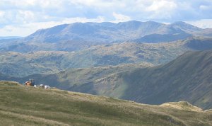
Furness Fells
Encyclopedia
Furness
Furness is a peninsula in south Cumbria, England. At its widest extent, it is considered to cover the whole of North Lonsdale, that part of the Lonsdale hundred that is an exclave of the historic county of Lancashire, lying to the north of Morecambe Bay....
region of Cumbria
Cumbria
Cumbria , is a non-metropolitan county in North West England. The county and Cumbria County Council, its local authority, came into existence in 1974 after the passage of the Local Government Act 1972. Cumbria's largest settlement and county town is Carlisle. It consists of six districts, and in...
, England
England
England is a country that is part of the United Kingdom. It shares land borders with Scotland to the north and Wales to the west; the Irish Sea is to the north west, the Celtic Sea to the south west, with the North Sea to the east and the English Channel to the south separating it from continental...
. Historically
Historic counties of England
The historic counties of England are subdivisions of England established for administration by the Normans and in most cases based on earlier Anglo-Saxon kingdoms and shires...
part of Lancashire
Lancashire
Lancashire is a non-metropolitan county of historic origin in the North West of England. It takes its name from the city of Lancaster, and is sometimes known as the County of Lancaster. Although Lancaster is still considered to be the county town, Lancashire County Council is based in Preston...
, the Furness Fells or High Furness is the name given to the upland part of Furness, that is, that part of Furness lying north of the line between Ulverston
Ulverston
Ulverston is a market town and civil parish in the South Lakeland district of Cumbria in north-west England. Historically part of Lancashire, the town is located in the Furness area, close to the Lake District, and just north of Morecambe Bay....
and Ireleth
Askam and Ireleth
During the Middle Ages, the entire area was controlled by the Cistercian monks of Furness Abbey. During this time, Ireleth was little more than one of many farming communities in Furness. The iron ore developments of Askam largely bypassed Ireleth, and the village developed slowly, housing farmers...
. The hills lie largely within the English
England
England is a country that is part of the United Kingdom. It shares land borders with Scotland to the north and Wales to the west; the Irish Sea is to the north west, the Celtic Sea to the south west, with the North Sea to the east and the English Channel to the south separating it from continental...
Lake District
Lake District
The Lake District, also commonly known as The Lakes or Lakeland, is a mountainous region in North West England. A popular holiday destination, it is famous not only for its lakes and its mountains but also for its associations with the early 19th century poetry and writings of William Wordsworth...
.
The term Furness Fells is also sometimes used as a synonym with Coniston Fells, perhaps partly as a result of the placing of the words "Furness Fells" on some Ordnance Survey
Ordnance Survey
Ordnance Survey , an executive agency and non-ministerial government department of the Government of the United Kingdom, is the national mapping agency for Great Britain, producing maps of Great Britain , and one of the world's largest producers of maps.The name reflects its creation together with...
1:250 000 maps. The Coniston Fells properly form only part of the Furness Fells, albeit with all the highest mountains; other fells in Furness are of lower altitude. The Coniston Fells form part of the Southern Fells
Southern Fells
Image:Annotated Scafell range.jpg|thumb|300px|The Scafellsrect 23 372 252 419 Slight Side rect 173 794 560 834 Scafell East Buttressrect 707 787 893 861 Esk Pike or Crag rect 245 303 409 358 Sca Fell rect 408 238 637 280 Mickledore Image:Annotated Scafell range.jpg|thumb|300px|The Scafellsrect 23...
of the Lake District as defined by Alfred Wainwright
Alfred Wainwright
Alfred Wainwright MBE was a British fellwalker, guidebook author and illustrator. His seven-volume Pictorial Guide to the Lakeland Fells, published between 1955 and 1966 and consisting entirely of reproductions of his manuscript, has become the standard reference work to 214 of the fells of the...
.
Coniston Fells
The Coniston Fells are separated from the Scafell and BowfellBowfell
Bowfell is a pyramid-shaped mountain lying at the heart of the English Lake District, in the Southern Fells area. It is the sixth highest mountain in the lakes and one of the most popular of the Lake District fells...
massif to their north by Wrynose Pass
Wrynose Pass
The Wrynose Pass is a mountain pass in the Lake District National Park in Cumbria, England between the Duddon Valley and Little Langdale.-Road:...
, and are surrounded on all other sides by lower ground. Coniston Old Man, the highest summit in the group, is the farthest south 2000-foot summit in the Lake District (using a 30 metre relative height
Topographic prominence
In topography, prominence, also known as autonomous height, relative height, shoulder drop , or prime factor , categorizes the height of the mountain's or hill's summit by the elevation between it and the lowest contour line encircling it and no higher summit...
criterion to determine what a summit is).
The tops of the Coniston Fells may be climbed from many points, including the village of Coniston
Coniston, Cumbria
Coniston is a village and civil parish in the Furness region of Cumbria, England. It is located in the southern part of the Lake District National Park, between Coniston Water, the third longest lake in the Lake District, and Coniston Old Man; about north east of Barrow-in-Furness.-Geography and...
at their base, or from Seathwaite in the Duddon Valley
Duddon Valley
The Duddon Valley is a valley in the Lake District National Park in Cumbria, England. The River Duddon flows through the valley, rising in the mountains between Eskdale and Langdale, before flowing into the Irish Sea near Broughton in Furness...
, or from Wrynose Pass. Seathwaite Tarn
Seathwaite Tarn
Seathwaite Tarn is a reservoir in the Furness Fells within the English Lake District. It is located to the south of Grey Friar and to the west of Brim Fell and north east of the village of Seathwaite on the east of the Duddon Valley.In order to create a source of drinking water the existing tarn...
above the Duddon is the third-largest tarn in the Lake District; Levers Water, Low Water, Goat's Water and Blind Tarn are also located in the Coniston Fells group.
Coniston Fells Summits
- Coniston Old Man, 803m
- Swirl HowSwirl HowSwirl How is a fell in the English Lake District. It stands between Coniston and the Duddon Valley in the southern part of the District.The Coniston Fells form the watershed between Coniston Water and the Duddon valley to the west. The range begins at Wrynose Pass and runs south for around...
, 802m - Dow CragDow CragDow Crag is a fell in the English Lake District near Coniston, Cumbria. The eastern face is one of the many rock faces in the Lake District used for rock climbing....
, 778m - Grey FriarGrey FriarGrey Friar is a fell in the English Lake District, it is one of the Coniston Fells and is situated 13 kilometres west-south-west of Ambleside. It reaches a height of 770 metres and stands to the north west of the other Coniston Fells, a little off the beaten track and tends to be the least visited...
, 773m - WetherlamWetherlamWetherlam is a mountain in the English Lake District. It is the most northerly of the Coniston Fells, the range of fells to the north-west of Coniston village; its north-east slopes descend to Little Langdale.-Topography:...
, 763m - Black SailsBlack SailsBlack Sails EP is an extended play by American rock band AFI. It was released on April 27, 1999 through Nitro Records. Only 5,000 copies were pressed. It is a sampler of the band's fourth studio album Black Sails in the Sunset.-Background:...
, 745m - Great Intake, 489m.
These summits all have more than 30 metres of relative height
Topographic prominence
In topography, prominence, also known as autonomous height, relative height, shoulder drop , or prime factor , categorizes the height of the mountain's or hill's summit by the elevation between it and the lowest contour line encircling it and no higher summit...
(a commonly used criterion for being a separate summit). Alfred Wainwright
Alfred Wainwright
Alfred Wainwright MBE was a British fellwalker, guidebook author and illustrator. His seven-volume Pictorial Guide to the Lakeland Fells, published between 1955 and 1966 and consisting entirely of reproductions of his manuscript, has become the standard reference work to 214 of the fells of the...
included three more tops: Great Carrs
Great Carrs
Great Carrs is a fell in the English Lake District. It stands above Wrynose Pass in the southern part of the District.-Topography:The Coniston Fells form the watershed between Coniston Water and the Duddon valley to the west. The range begins at Wrynose Pass and runs south for around 10 miles...
, Brim Fell
Brim Fell
Brim Fell is a fell in the English Lake District. It stands to the west of Coniston village in the southern part of the District.-Topography:The Coniston Fells form the watershed between Coniston Water and the Duddon valley to the west...
and Walna Scar
Walna Scar
Walna Scar is a hill in the English Lake District, lying just south of a pass of the same name in the Coniston Hills. Its summit is only slightly higher than the pass, but few reach it, preferring instead to head north from the top of the pass to Dow Crag and the other Coniston Fells...
, and included mention of White Maiden and White Pike. South of White Pike there is a significant loss of altitude before the Dunnerdale Fells, which therefore while forming part of the Furness Fells may be said to be distinct from the Coniston Fells.