
Bethlehem Pike
Encyclopedia
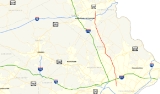
Bethlehem Pike is a historic 41 mi (66 km) long road in the U.S. state
of Pennsylvania
, connecting Philadelphia
and Bethlehem, Pennsylvania
. It began as a Native American
path called the Minsi Trail which evolved into a colonial
highway called the King's Road in the 1760s. Most of the route later became part of U.S. Route 309, now Pennsylvania Route 309
.
pathway known as the Minsi Trail. Named after the Minsi Indians, the trail was routed between the Blue Mountains
and the lands to the south. In December of 1740, David Nitschmann
and his party went to Bethlehem and Nazareth along this trail. A year later, a second party joined the first, traversing the same pathway. Count Zinzendorf, was included in the second party who visited the pioneers in the cabin along the banks of the Monocacy Creek
. On Christmas Eve, Zinzendorf maintained a famous love-feast service, which led to the settlement of Bethlehem.
After the discovery of Bethlehem, a number of settlements began to rise along the route, causing a constant use of it and the highway to be called King's Road. The first trip made by George Klein
was Stage Wagon on September 10, 1763. He later made regular trips between Philadelphia and Bethlehem on a weekly basis. He started on Mondays from the Sun Inn in Bethlehem, and returned from the King of Prussia
Inn in Philadelphia, on Thursdays. Bethlehem Pike and Germantown Avenue were the first two segments of the King's Highway, the main road carrying passengers and their goods between Philadelphia and the north.
In the northern regions of Philadelphia, the pike intersected the Old York Road
. According to a legend, Tammany, the great Indian chief, presented all lands within the young Germans' vision. Following the gift they received from the natives, they concluded the ritual, the sun rose, and the men named the spot Rising Sun. During the Revoluntionary War
, British officers gathered near the southern terminus of the modern day pike. They gathered in the days their army faced the Colonials at Whitemarsh
. Further north along the route in the Whitemarsh Valley is the site where George Washington
held Howe
at bay, thus becoming famous in history as Church Hill
. Before heading to Valley Forge
, Washington and his army encamped here on December 11, 1777.
During the revolution, the pike delt with a busy time period, for Bethlehem was crowded with officers, prisoners, and soldiers from the war. There was great excitement in Bethlehem on September 13, 1777, when the Patriot Army
retreated from Philadelphia. Later, a letter had arrived by express courier from David Rittenhouse
, announcing that all the military stores, in 700 wagons, were sent north on the Bethlehem Pike. Even the church and state bells were sent over for safekeeping on the pike. In Bethlehem, the wagon carrying the Liberty Bell
broke down. The bells had to be unloaded on September 25, 1777. Eventually the wagon was repaired and they were sent to Allentown, where it was hidden from danger on Hamilton Street. The road traverses Rockhill Township, where the New Jersey
and Pennsylvania
armies listened to Richard Peters
in 1799, a member of the Colonial assembly. They camped at Seller's Tavern, today known as Sellersville.
On March 11, 1834, the governor of Pennsylvania signed a license authorizing the Bethlehem Turnpike Road Company to erect many of its gates. The turnpike was authorized to collect tolls from travelers on horses, cattle, and carriages. In 1904, the Bethlehem Pike became a free road after it was tolled for 100 years. The tolls were removed in 1910. When Pennsylvania signed the Sproul Road Bill on May 31, 1911, the state began taking over the highways across the commonwealth. The bill defined the Bethlehem Pike as Legislative Route 297 (LR 297) in Northampton County
and LR 153 in Lehigh County
.
The pike was defined as LR 153 through the counties of Bucks and Montgomery
.
was given a number and the majority of the Bethlehem Pike was signed as U.S. Route 309 (US 309). During a three-decade period after the system was created, the pike was designated as Pennsylvania Route 12 (PA 12) from Bethlehem to Center Valley
. South of Center Valley, the route was known as US 309. By 1960, a portion of the road was designated as Pennsylvania Route 191
, when it replaced the entire routing of PA 12.
North of Philadelphia, US 309 was designated on the newly built Fort Washington
Expressway, east of the original alignment on the Bethlehem Pike. By 1970, US 309 was deleted and replaced by Pennsylvania Route 309
. Following the commission of the route, PA 309 was moved to a newly constructed freeway, bypassing Sellersville
, and west of the Bethlehem Pike. Six years later, Interstate 378 was deleted and PA 191 was truncated, thus designating their former alignments as Pennsylvania Route 378
.
in the Lehigh
and Delaware Valley
s. In Philadelphia, the road is signed as SR 4017, with a daily traffic of 15,000 vehicles. The pike is routed as SR 2018 in Montgomery County
, while parallel to PA 309. North of Fort Washington
, the road is known as PA 309, with an average of 17,000 to 21,000 vehicles a day. In Sellersville
, the pike is signed as SR 4013, south of PA 152
, and SR 4085 north of PA 152. From Quakertown
to Center Valley
, the pike has an old alignment west of the current designation on PA 309. In the Quakertown area, the PA 309 segment of the pike averages a daily traffic of 18,000 vehicles. North of Center Valley, the road is aligned as PA 378, with an average traffic of 17,000 vehicles a day. The northern most segment of the pike is known as Main Street in Bethlehem
.
Lower Gwynedd
formed a project to improve the Bethlehem Pike within the township and estimated to cost $500,000.
U.S. state
A U.S. state is any one of the 50 federated states of the United States of America that share sovereignty with the federal government. Because of this shared sovereignty, an American is a citizen both of the federal entity and of his or her state of domicile. Four states use the official title of...
of Pennsylvania
Pennsylvania
The Commonwealth of Pennsylvania is a U.S. state that is located in the Northeastern and Mid-Atlantic regions of the United States. The state borders Delaware and Maryland to the south, West Virginia to the southwest, Ohio to the west, New York and Ontario, Canada, to the north, and New Jersey to...
, connecting Philadelphia
Philadelphia, Pennsylvania
Philadelphia is the largest city in the Commonwealth of Pennsylvania and the county seat of Philadelphia County, with which it is coterminous. The city is located in the Northeastern United States along the Delaware and Schuylkill rivers. It is the fifth-most-populous city in the United States,...
and Bethlehem, Pennsylvania
Bethlehem, Pennsylvania
Bethlehem is a city in Lehigh and Northampton Counties in the Lehigh Valley region of eastern Pennsylvania, in the United States. As of the 2010 census, the city had a total population of 74,982, making it the seventh largest city in Pennsylvania, after Philadelphia, Pittsburgh, Allentown, Erie,...
. It began as a Native American
Native Americans in the United States
Native Americans in the United States are the indigenous peoples in North America within the boundaries of the present-day continental United States, parts of Alaska, and the island state of Hawaii. They are composed of numerous, distinct tribes, states, and ethnic groups, many of which survive as...
path called the Minsi Trail which evolved into a colonial
Colonial America
The colonial history of the United States covers the history from the start of European settlement and especially the history of the thirteen colonies of Britain until they declared independence in 1776. In the late 16th century, England, France, Spain and the Netherlands launched major...
highway called the King's Road in the 1760s. Most of the route later became part of U.S. Route 309, now Pennsylvania Route 309
Pennsylvania Route 309
Pennsylvania Route 309 is a major highway which runs for 134 miles through Pennsylvania in the United States. It connects Philadelphia and its northern suburbs to Allentown, Hazleton, and Wilkes-Barre. A limited-access highway portion of PA 309 in the Wilkes-Barre area is known as the North...
.
Colonial Age
The Bethlehem Pike originated from a Native AmericanNative Americans in the United States
Native Americans in the United States are the indigenous peoples in North America within the boundaries of the present-day continental United States, parts of Alaska, and the island state of Hawaii. They are composed of numerous, distinct tribes, states, and ethnic groups, many of which survive as...
pathway known as the Minsi Trail. Named after the Minsi Indians, the trail was routed between the Blue Mountains
Blue Mountain (Pennsylvania)
Blue Mountain is a ridge that forms the eastern edge of the Appalachian mountain range in the U.S. state of Pennsylvania. It cuts across the eastern half of the state from New Jersey to Maryland, providing a distinct boundary between a number of Pennsylvania's geographical and cultural regions...
and the lands to the south. In December of 1740, David Nitschmann
David Nitschmann der Bischof
David Nitschmann der Bischof was with Johann Leonhard Dober one of the two first missionaries of the Moravian Brethren in the West Indies in 1732, and the first Bishop of the Renewed Unitas Fratrum, the Moravian Church...
and his party went to Bethlehem and Nazareth along this trail. A year later, a second party joined the first, traversing the same pathway. Count Zinzendorf, was included in the second party who visited the pioneers in the cabin along the banks of the Monocacy Creek
Monocacy Creek
Monocacy Creek is a tributary of the Lehigh River in Northampton County, Pennsylvania in the United States.One of only 56 limestone streams in the state of Pennsylvania, the creek's headwaters lie in the slate belt, near the borough of Chapman....
. On Christmas Eve, Zinzendorf maintained a famous love-feast service, which led to the settlement of Bethlehem.
After the discovery of Bethlehem, a number of settlements began to rise along the route, causing a constant use of it and the highway to be called King's Road. The first trip made by George Klein
George Klein
George Johann Klein, was a Hamilton, Ontario-born Canadian inventor who is often called the most productive inventor in Canada in the 20th century. Although he struggled through high school and got a grade C he managed to get in at UofT in Toronto to become an inventor...
was Stage Wagon on September 10, 1763. He later made regular trips between Philadelphia and Bethlehem on a weekly basis. He started on Mondays from the Sun Inn in Bethlehem, and returned from the King of Prussia
King of Prussia, Pennsylvania
King of Prussia is a census-designated place in Upper Merion Township, Montgomery County, Pennsylvania, United States. As of the 2010 census, its population was 19,936. The community took its name in the 18th century from a local tavern named the King of Prussia Inn, which was named after...
Inn in Philadelphia, on Thursdays. Bethlehem Pike and Germantown Avenue were the first two segments of the King's Highway, the main road carrying passengers and their goods between Philadelphia and the north.
In the northern regions of Philadelphia, the pike intersected the Old York Road
Old York Road
Old York Road or King's Highway is a roadway that was built in the 18th century to connect Philadelphia, Pennsylvania with New York City, New York. Through New Jersey it was built along the Raritan "Naraticong Trail"...
. According to a legend, Tammany, the great Indian chief, presented all lands within the young Germans' vision. Following the gift they received from the natives, they concluded the ritual, the sun rose, and the men named the spot Rising Sun. During the Revoluntionary War
American Revolution
The American Revolution was the political upheaval during the last half of the 18th century in which thirteen colonies in North America joined together to break free from the British Empire, combining to become the United States of America...
, British officers gathered near the southern terminus of the modern day pike. They gathered in the days their army faced the Colonials at Whitemarsh
Battle of White Marsh
The Battle of White Marsh or Battle of Edge Hill was a battle of the Philadelphia campaign of the American Revolutionary War fought December 5–8, 1777, in the area surrounding Whitemarsh Township, Pennsylvania...
. Further north along the route in the Whitemarsh Valley is the site where George Washington
George Washington
George Washington was the dominant military and political leader of the new United States of America from 1775 to 1799. He led the American victory over Great Britain in the American Revolutionary War as commander-in-chief of the Continental Army from 1775 to 1783, and presided over the writing of...
held Howe
William Howe, 5th Viscount Howe
William Howe, 5th Viscount Howe, KB, PC was a British army officer who rose to become Commander-in-Chief of British forces during the American War of Independence...
at bay, thus becoming famous in history as Church Hill
Church Hill
Church Hill, also known as the St. John's Church Historic District, is an Old and Historic District in Richmond, Virginia. This district encompasses the original land plat of the city of Richmond. Church Hill is the eastern terminus of Broad Street, a major east-west thoroughfare in the Richmond...
. Before heading to Valley Forge
Valley Forge
Valley Forge in Pennsylvania was the site of the military camp of the American Continental Army over the winter of 1777–1778 in the American Revolutionary War.-History:...
, Washington and his army encamped here on December 11, 1777.
During the revolution, the pike delt with a busy time period, for Bethlehem was crowded with officers, prisoners, and soldiers from the war. There was great excitement in Bethlehem on September 13, 1777, when the Patriot Army
Patriot (American Revolution)
Patriots is a name often used to describe the colonists of the British Thirteen United Colonies who rebelled against British control during the American Revolution. It was their leading figures who, in July 1776, declared the United States of America an independent nation...
retreated from Philadelphia. Later, a letter had arrived by express courier from David Rittenhouse
David Rittenhouse
David Rittenhouse was a renowned American astronomer, inventor, clockmaker, mathematician, surveyor, scientific instrument craftsman and public official...
, announcing that all the military stores, in 700 wagons, were sent north on the Bethlehem Pike. Even the church and state bells were sent over for safekeeping on the pike. In Bethlehem, the wagon carrying the Liberty Bell
Liberty Bell
The Liberty Bell is an iconic symbol of American Independence, located in Philadelphia, Pennsylvania. Formerly placed in the steeple of the Pennsylvania State House , the bell was commissioned from the London firm of Lester and Pack in 1752, and was cast with the lettering "Proclaim LIBERTY...
broke down. The bells had to be unloaded on September 25, 1777. Eventually the wagon was repaired and they were sent to Allentown, where it was hidden from danger on Hamilton Street. The road traverses Rockhill Township, where the New Jersey
New Jersey
New Jersey is a state in the Northeastern and Middle Atlantic regions of the United States. , its population was 8,791,894. It is bordered on the north and east by the state of New York, on the southeast and south by the Atlantic Ocean, on the west by Pennsylvania and on the southwest by Delaware...
and Pennsylvania
Pennsylvania
The Commonwealth of Pennsylvania is a U.S. state that is located in the Northeastern and Mid-Atlantic regions of the United States. The state borders Delaware and Maryland to the south, West Virginia to the southwest, Ohio to the west, New York and Ontario, Canada, to the north, and New Jersey to...
armies listened to Richard Peters
Richard Peters (Continental Congress)
Richard Peters sometimes Richard Peters, Jr., to distinguish from his uncle, though this can also mean his son Richard), was an American lawyer, jurist, and politician from Philadelphia, Pennsylvania. He was a delegate for Pennsylvania to the Continental Congress in 1782 and 1783...
in 1799, a member of the Colonial assembly. They camped at Seller's Tavern, today known as Sellersville.
Bethlehem Turnpike
In 1804, the route became a toll road known as the Bethlehem Turnpike. Tolls were voluntary only during morning hours.On March 11, 1834, the governor of Pennsylvania signed a license authorizing the Bethlehem Turnpike Road Company to erect many of its gates. The turnpike was authorized to collect tolls from travelers on horses, cattle, and carriages. In 1904, the Bethlehem Pike became a free road after it was tolled for 100 years. The tolls were removed in 1910. When Pennsylvania signed the Sproul Road Bill on May 31, 1911, the state began taking over the highways across the commonwealth. The bill defined the Bethlehem Pike as Legislative Route 297 (LR 297) in Northampton County
Northampton County, Pennsylvania
As of the 2010 census, the county was 86.3% White, 5.0% Black or African American, 0.2% Native American or Alaskan Native, 2.4% Asian, 0.0% Native Hawaiian, 2.2% were two or more races, and 3.8% were some other race. 10.5% of the population were of Hispanic or Latino ancestry.As of the census of...
and LR 153 in Lehigh County
Lehigh County, Pennsylvania
-Climate:Most of the county's climate is considered to fall in the humid continental climate zone. Summers are typically hot and muggy, fall and spring are generally mild, and winter is cold. Precipitation is almost uniformly distributed throughout the year....
.
The pike was defined as LR 153 through the counties of Bucks and Montgomery
Montgomery County, Pennsylvania
Montgomery County is a county located in the U.S. state of Pennsylvania, in the United States. As of 2010, the population was 799,874, making it the third most populous county in Pennsylvania . The county seat is Norristown.The county was created on September 10, 1784, out of land originally part...
.
Age of numbered roads
In 1926, when the U.S. Numbered Highway System was established, each designated trail in the United StatesUnited States
The United States of America is a federal constitutional republic comprising fifty states and a federal district...
was given a number and the majority of the Bethlehem Pike was signed as U.S. Route 309 (US 309). During a three-decade period after the system was created, the pike was designated as Pennsylvania Route 12 (PA 12) from Bethlehem to Center Valley
Center Valley, Pennsylvania
Center Valley is an unincorporated village one mile north of Coopersburg, Pennsylvania, at the intersection of Pennsylvania Route 309 and Pennsylvania Route 378 in Upper Saucon Township, Lehigh County, Pennsylvania, in the United States....
. South of Center Valley, the route was known as US 309. By 1960, a portion of the road was designated as Pennsylvania Route 191
Pennsylvania Route 191
Pennsylvania Route 191 is a -long state highway in the U.S. state of Pennsylvania. The route, a major non-freeway corridor connecting the Lehigh Valley to The Poconos in eastern Pennsylvania, is designated from U.S...
, when it replaced the entire routing of PA 12.
North of Philadelphia, US 309 was designated on the newly built Fort Washington
Fort Washington, Pennsylvania
Fort Washington is an unincorporated census-designated place and suburb of Philadelphia in Montgomery County, Pennsylvania, United States. The population was 5,446 at the 2010 census.-Prior to the Revolutionary War:...
Expressway, east of the original alignment on the Bethlehem Pike. By 1970, US 309 was deleted and replaced by Pennsylvania Route 309
Pennsylvania Route 309
Pennsylvania Route 309 is a major highway which runs for 134 miles through Pennsylvania in the United States. It connects Philadelphia and its northern suburbs to Allentown, Hazleton, and Wilkes-Barre. A limited-access highway portion of PA 309 in the Wilkes-Barre area is known as the North...
. Following the commission of the route, PA 309 was moved to a newly constructed freeway, bypassing Sellersville
Sellersville, Pennsylvania
Sellersville is a borough in Bucks County, Pennsylvania, United States. The population was 4,249 at the 2010 census. Sellersville is part of Pennridge School District.-Geography:Sellersville is located at ....
, and west of the Bethlehem Pike. Six years later, Interstate 378 was deleted and PA 191 was truncated, thus designating their former alignments as Pennsylvania Route 378
Pennsylvania Route 378
Pennsylvania Route 378 is a north-to-south road in Lehigh and Northampton counties. Its northern terminus is at U.S. Route 22 in Bethlehem and the portion north of the Lehigh River is a freeway. The highway was once Interstate 378 but when Interstate 78 was rerouted from U.S...
.
Today
The modern Bethlehem Pike is mostly designated as Pennsylvania Route 309Pennsylvania Route 309
Pennsylvania Route 309 is a major highway which runs for 134 miles through Pennsylvania in the United States. It connects Philadelphia and its northern suburbs to Allentown, Hazleton, and Wilkes-Barre. A limited-access highway portion of PA 309 in the Wilkes-Barre area is known as the North...
in the Lehigh
Lehigh Valley
The Lehigh Valley, known officially by the United States Census Bureau as the Allentown-Bethlehem-Easton, PA-NJ metropolitan area and referred to locally as The Valley and A-B-E, is a metropolitan region consisting of Lehigh, Northampton, Berks, and Carbon counties in eastern Pennsylvania and...
and Delaware Valley
Delaware Valley
The Delaware Valley is a term used to refer to the valley where the Delaware River flows, along with the surrounding communities. This includes the metropolitan area centered on the city of Philadelphia. Such educational institutions as Delaware Valley Regional High School in Alexandria Township...
s. In Philadelphia, the road is signed as SR 4017, with a daily traffic of 15,000 vehicles. The pike is routed as SR 2018 in Montgomery County
Montgomery County, Pennsylvania
Montgomery County is a county located in the U.S. state of Pennsylvania, in the United States. As of 2010, the population was 799,874, making it the third most populous county in Pennsylvania . The county seat is Norristown.The county was created on September 10, 1784, out of land originally part...
, while parallel to PA 309. North of Fort Washington
Fort Washington, Pennsylvania
Fort Washington is an unincorporated census-designated place and suburb of Philadelphia in Montgomery County, Pennsylvania, United States. The population was 5,446 at the 2010 census.-Prior to the Revolutionary War:...
, the road is known as PA 309, with an average of 17,000 to 21,000 vehicles a day. In Sellersville
Sellersville, Pennsylvania
Sellersville is a borough in Bucks County, Pennsylvania, United States. The population was 4,249 at the 2010 census. Sellersville is part of Pennridge School District.-Geography:Sellersville is located at ....
, the pike is signed as SR 4013, south of PA 152
Pennsylvania Route 152
Pennsylvania Route 152 is a 25 mile long state highway located in the US state of Pennsylvania. The route, travels north–south from PA Route 309 located in Cedarbrook north to PA Route 309 located east of Telford.PA 152 is unique to other Pennsylvania Highways because it ends at two...
, and SR 4085 north of PA 152. From Quakertown
Quakertown, Pennsylvania
Quakertown is a borough in Bucks County, Pennsylvania, in the United States. As of the 2010 census, it had a population of 8,979. The borough is south of Bethlehem and north of Philadelphia, making Quakertown a border town of both the Delaware Valley and Lehigh Valley metropolitan areas...
to Center Valley
Center Valley, Pennsylvania
Center Valley is an unincorporated village one mile north of Coopersburg, Pennsylvania, at the intersection of Pennsylvania Route 309 and Pennsylvania Route 378 in Upper Saucon Township, Lehigh County, Pennsylvania, in the United States....
, the pike has an old alignment west of the current designation on PA 309. In the Quakertown area, the PA 309 segment of the pike averages a daily traffic of 18,000 vehicles. North of Center Valley, the road is aligned as PA 378, with an average traffic of 17,000 vehicles a day. The northern most segment of the pike is known as Main Street in Bethlehem
Bethlehem, Pennsylvania
Bethlehem is a city in Lehigh and Northampton Counties in the Lehigh Valley region of eastern Pennsylvania, in the United States. As of the 2010 census, the city had a total population of 74,982, making it the seventh largest city in Pennsylvania, after Philadelphia, Pittsburgh, Allentown, Erie,...
.
Lower Gwynedd
Lower Gwynedd Township, Pennsylvania
Lower Gwynedd Township is a township in Montgomery County, Pennsylvania, United States. The population was 11,405 at the 2010 census. The township comprises four villages: Gwynedd, Gwynedd Valley, Penllyn, and Spring House....
formed a project to improve the Bethlehem Pike within the township and estimated to cost $500,000.