
.gif)
Blue Mountain (Pennsylvania)
Encyclopedia
Blue Mountain is a ridge that forms the eastern edge of the Appalachian mountain range in the U.S. state
of Pennsylvania
. It cuts across the eastern half of the state from New Jersey
to Maryland
, providing a distinct boundary between a number of Pennsylvania's geographical and cultural regions. To its northwest side are the southern and central mountains and valleys, the "coal region
," and the Poconos
. To its southeast side are the Cumberland Valley
, the "capital region," Pennsylvania Dutch Country
, and the Lehigh Valley
.
just north of the Pennsylvania Turnpike
, near the borough of Newburg
. Most of the ridgecrest, however, only reaches between 1400 feet (426.7 m) and 1700 feet (518.2 m) in elevation. The mountain's width varies from 1 miles (1.6 km) to 3 miles (4.8 km).
The southwestern end of the mountain is at Big Gap, west of Shippensburg
. (The mountain ridge continues to the southwest towards Maryland under the name of Broad Mountain.) The northeastern end of the mountain is at the Delaware Water Gap
on the New Jersey border. Mount Minsi
, forms the promontory overlooking the Delaware River. The ridge of Blue Mountain continues northeast into New Jersey as the Kittatinny Mountains
.
Blue Mountain marks the boundary between the Great Appalachian Valley
and the main Ridge-and-valley Appalachians
.
s.
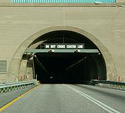 The Pennsylvania Turnpike
system passes through the Blue Mountain at two points.
Both tunnels (each consisting of two tubes) carry two lanes in each direction of travel.
Blue Mountain School District
is named after the mountain range. It is located just off Rt. 61 in Schuylkill Haven, Pennsylvania
.
U.S. state
A U.S. state is any one of the 50 federated states of the United States of America that share sovereignty with the federal government. Because of this shared sovereignty, an American is a citizen both of the federal entity and of his or her state of domicile. Four states use the official title of...
of Pennsylvania
Pennsylvania
The Commonwealth of Pennsylvania is a U.S. state that is located in the Northeastern and Mid-Atlantic regions of the United States. The state borders Delaware and Maryland to the south, West Virginia to the southwest, Ohio to the west, New York and Ontario, Canada, to the north, and New Jersey to...
. It cuts across the eastern half of the state from New Jersey
New Jersey
New Jersey is a state in the Northeastern and Middle Atlantic regions of the United States. , its population was 8,791,894. It is bordered on the north and east by the state of New York, on the southeast and south by the Atlantic Ocean, on the west by Pennsylvania and on the southwest by Delaware...
to Maryland
Maryland
Maryland is a U.S. state located in the Mid Atlantic region of the United States, bordering Virginia, West Virginia, and the District of Columbia to its south and west; Pennsylvania to its north; and Delaware to its east...
, providing a distinct boundary between a number of Pennsylvania's geographical and cultural regions. To its northwest side are the southern and central mountains and valleys, the "coal region
Coal Region
The Coal Region is a term used to refer to an area of Northeastern Pennsylvania in the central Appalachian Mountains comprising Lackawanna, Luzerne, Columbia, Carbon, Schuylkill, Northumberland, and the extreme northeast corner of Dauphin counties....
," and the Poconos
The Poconos
The Pocono Mountains is a region located in northeastern Pennsylvania, United States. The Poconos, located chiefly in Monroe and Pike counties , are an upland of the larger Allegheny Plateau...
. To its southeast side are the Cumberland Valley
Cumberland Valley
The Cumberland Valley is a constituent valley of the Great Appalachian Valley and a North American agricultural region within the Atlantic Seaboard watershed in Pennsylvania and Maryland....
, the "capital region," Pennsylvania Dutch Country
Pennsylvania Dutch Country
Pennsylvania Dutch Country refers to an area of southeastern Pennsylvania, United States that by the American Revolution had a high percentage of Pennsylvania Dutch inhabitants. Religiously, there was a large portion of Lutherans. There were also German Reformed, Moravian, Amish, Mennonite and...
, and the Lehigh Valley
Lehigh Valley
The Lehigh Valley, known officially by the United States Census Bureau as the Allentown-Bethlehem-Easton, PA-NJ metropolitan area and referred to locally as The Valley and A-B-E, is a metropolitan region consisting of Lehigh, Northampton, Berks, and Carbon counties in eastern Pennsylvania and...
.
Geography
The ridge of Blue Mountain runs for 150 miles (241.4 km) through Pennsylvania, reaching an elevation of 2270 feet (691.9 m) above sea levelSea level
Mean sea level is a measure of the average height of the ocean's surface ; used as a standard in reckoning land elevation...
just north of the Pennsylvania Turnpike
Pennsylvania Turnpike
The Pennsylvania Turnpike is a toll highway system operated by the Pennsylvania Turnpike Commission in the Commonwealth of Pennsylvania, United States. The three sections of the turnpike system total . The main section extends from Ohio to New Jersey and is long...
, near the borough of Newburg
Newburg, Pennsylvania
Newburg is the name of some places in the U.S. state of Pennsylvania:*Newburg, Blair County, Pennsylvania*Newburg, Clearfield County, Pennsylvania*Newburg, Cumberland County, Pennsylvania*Newburg, Huntingdon County, Pennsylvania...
. Most of the ridgecrest, however, only reaches between 1400 feet (426.7 m) and 1700 feet (518.2 m) in elevation. The mountain's width varies from 1 miles (1.6 km) to 3 miles (4.8 km).
The southwestern end of the mountain is at Big Gap, west of Shippensburg
Shippensburg, Pennsylvania
Shippensburg is a borough in Cumberland and Franklin counties in the U.S. state of Pennsylvania. Settled in 1730, Shippensburg lies in the Cumberland Valley, 41 miles west-southwest of Harrisburg, and is part of the Harrisburg–Carlisle Metropolitan Statistical Area. In 1900, 3,228 people...
. (The mountain ridge continues to the southwest towards Maryland under the name of Broad Mountain.) The northeastern end of the mountain is at the Delaware Water Gap
Delaware Water Gap
The Delaware Water Gap is on the border of New Jersey and Pennsylvania where the Delaware River cuts through a large ridge of the Appalachian Mountains...
on the New Jersey border. Mount Minsi
Mount Minsi
Mount Minsi forms the Pennsylvania side of the Delaware Water Gap, and is the eastern extent of the Blue Mountain. It is composed of sandstone and conglomerates of the Shawangunk Formation.- Hiking :...
, forms the promontory overlooking the Delaware River. The ridge of Blue Mountain continues northeast into New Jersey as the Kittatinny Mountains
Kittatinny Mountains
The Kittatinny Mountains are a long ridge traversing across northwestern New Jersey running in a northeast-southwest axis. It is the first major ridge in the far northeastern extension of the Ridge and Valley province of the Appalachian Mountains...
.
Blue Mountain marks the boundary between the Great Appalachian Valley
Great Appalachian Valley
The Great Valley, also called the Great Appalachian Valley or Great Valley Region, is one of the major landform features of eastern North America. It is a gigantic trough — a chain of valley lowlands — and the central feature of the Appalachian Mountain system...
and the main Ridge-and-valley Appalachians
Ridge-and-valley Appalachians
The Ridge-and-Valley Appalachians, also called the Ridge and Valley Province or the Valley and Ridge Appalachians, are a physiographic province of the larger Appalachian division and are also a belt within the Appalachian Mountains extending from southeastern New York through northwestern New...
.
Water gaps
Four of Pennsylvania's major rivers cut through Blue Mountain in water gapWater gap
A water gap is an opening or notch which flowing water has carved through a mountain range. Water gaps often offer a practical route for road and rail transport to cross mountain ridges.- Geology :...
s.
- The Delaware RiverDelaware RiverThe Delaware River is a major river on the Atlantic coast of the United States.A Dutch expedition led by Henry Hudson in 1609 first mapped the river. The river was christened the South River in the New Netherland colony that followed, in contrast to the North River, as the Hudson River was then...
, which forms Pennsylvania's eastern border with New Jersey, passes throughDelaware Water GapThe Delaware Water Gap is on the border of New Jersey and Pennsylvania where the Delaware River cuts through a large ridge of the Appalachian Mountains...
the ridge just southeast of StroudsburgStroudsburg, PennsylvaniaStroudsburg is a borough in Monroe County, Pennsylvania, United States. It is located in the Poconos region of the state, approximately five miles from the Delaware Water Gap, at the confluence of the Brodhead and Pocono Creeks. It is the county seat of Monroe County. Stroudsburg is part of the...
. - The Lehigh RiverLehigh RiverThe Lehigh River, a tributary of the Delaware River, is a river located in eastern Pennsylvania, in the United States. Part of the Lehigh, along with a number of its tributaries, is designated a Pennsylvania Scenic River by the state's Department of Conservation and Natural Resources...
, which feeds the Delaware at EastonEaston, PennsylvaniaEaston is a city in Northampton County, Pennsylvania, United States. The population was 26,800 as of the 2010 census. It is the county seat of Northampton County....
, passes throughLehigh Gap, PennsylvaniaThe Lehigh Gap, located in Lower Towamensing Township, Carbon County, Pennsylvania, is a water gap formed by the Lehigh River where it cuts through Blue Mountain in the state of Pennsylvania in the United States. The gap allows easy travel between Carbon County to the north and Lehigh and...
the ridge near PalmertonPalmerton, PennsylvaniaPalmerton is a borough in Carbon County, Pennsylvania, United States. It is located in the coal region of the state. It is a part of lower Carbon County, which is considered part of the Lehigh Valley and the greater Allentown Metropolitan Area....
. - The Schuylkill RiverSchuylkill RiverThe Schuylkill River is a river in Pennsylvania. It is a designated Pennsylvania Scenic River.The river is about long. Its watershed of about lies entirely within the state of Pennsylvania. The source of its eastern branch is in the Appalachian Mountains at Tuscarora Springs, near Tamaqua in...
, which feeds the Delaware at PhiladelphiaPhiladelphia, PennsylvaniaPhiladelphia is the largest city in the Commonwealth of Pennsylvania and the county seat of Philadelphia County, with which it is coterminous. The city is located in the Northeastern United States along the Delaware and Schuylkill rivers. It is the fifth-most-populous city in the United States,...
, passes through the ridge just north of HamburgHamburg, PennsylvaniaHamburg is a borough in Berks County, Pennsylvania, United States. The population was 4,114 at the 2000 census. The town is named after Hamburg, Germany.-Geography:Hamburg is located at ....
. - The Susquehanna RiverSusquehanna RiverThe Susquehanna River is a river located in the northeastern United States. At long, it is the longest river on the American east coast that drains into the Atlantic Ocean, and with its watershed it is the 16th largest river in the United States, and the longest river in the continental United...
, which feeds the Chesapeake BayChesapeake BayThe Chesapeake Bay is the largest estuary in the United States. It lies off the Atlantic Ocean, surrounded by Maryland and Virginia. The Chesapeake Bay's drainage basin covers in the District of Columbia and parts of six states: New York, Pennsylvania, Delaware, Maryland, Virginia, and West...
, passes through the ridge just north of HarrisburgHarrisburg, PennsylvaniaHarrisburg is the capital of Pennsylvania. As of the 2010 census, the city had a population of 49,528, making it the ninth largest city in Pennsylvania...
, Pennsylvania's capital.
The Pennsylvania Turnpike
Pennsylvania Turnpike
The Pennsylvania Turnpike is a toll highway system operated by the Pennsylvania Turnpike Commission in the Commonwealth of Pennsylvania, United States. The three sections of the turnpike system total . The main section extends from Ohio to New Jersey and is long...
system passes through the Blue Mountain at two points.
- The Blue Mountain TunnelBlue Mountain TunnelThe Blue Mountain Tunnel is one of two tunnels through Blue Mountain in Pennsylvania, located west of Newburg. It is one of seven tunnels completed for the Pennsylvania Turnpike mainline, and at in length, is the shortest of the four still in use today. The Blue Mountain Tunnel is to the east...
carries the Turnpike's east-west mainline (Interstate 76Interstate 76 (east)Interstate 76 is an Interstate Highway in the United States, running 435 miles from an interchange with Interstate 71 west of Akron, Ohio, east to Interstate 295 near Camden, New Jersey....
) through the ridge in northern Franklin CountyFranklin County, PennsylvaniaAs of the census of 2000, there were 129,313 people, 50,633 households, and 36,405 families residing in the county. The population density was 168 people per square mile . There were 53,803 housing units at an average density of 70 per square mile...
. The turnpike also tunnels through a parallel ridge of the same mountain just to the west (with the two tunnel portals only 0.2 mile (0.321868 km) apart; the name of this western tunnel is Kittatinny MountainKittatinny Mountain TunnelThe Kittatinny Mountain Tunnel is a tunnel through Kittatinny Mountain in Franklin County, Pennsylvania. It is one of seven tunnels completed for the Pennsylvania Turnpike, and one of four still in use today. The Kittatinny Mountain Tunnel is 4727 feet in length, and is located 600 feet west of...
. - The Lehigh TunnelLehigh TunnelThe Lehigh Tunnel is a pair of road tunnels that carries the Pennsylvania Turnpike Northeast Extension under the Blue Mountain north from Interstate 78 to the Scranton/Wilkes-Barre area between mileposts 70.7 to 71.5. The tunnel was called the Lehigh Tunnel to avoid confusion with the existing...
, so named to avoid confusion with the former, carries the Turnpike's north-south Northeast Extension (Interstate 476Interstate 476Interstate 476 is a auxiliary Interstate Highway in the U.S. state of Pennsylvania designated between Interstate 95 near Chester and Interstate 81 near Scranton, serving as the primary north–south Interstate corridor through eastern Pennsylvania....
) through the ridge between LehighLehigh County, Pennsylvania-Climate:Most of the county's climate is considered to fall in the humid continental climate zone. Summers are typically hot and muggy, fall and spring are generally mild, and winter is cold. Precipitation is almost uniformly distributed throughout the year....
and CarbonCarbon County, PennsylvaniaAs of the census of 2000, there were 58,802 people, 23,701 households, and 16,424 families residing in the county. The population density was 154 people per square mile . There were 30,492 housing units at an average density of 80 per square mile...
Counties.
Both tunnels (each consisting of two tubes) carry two lanes in each direction of travel.
Blue Mountain attractions in Pennsylvania
- The Appalachian TrailAppalachian TrailThe Appalachian National Scenic Trail, generally known as the Appalachian Trail or simply the AT, is a marked hiking trail in the eastern United States extending between Springer Mountain in Georgia and Mount Katahdin in Maine. It is approximately long...
is concurrent with the top of the ridge from New Jersey to northern Lebanon CountyLebanon County, PennsylvaniaAs of the census of 2000, there were 120,327 people and 32,771 families residing in the county. The population density was 332 people per square mile . There were 49,320 housing units at an average density of 136 per square mile...
. - Hawk Mountain SanctuaryHawk Mountain SanctuaryHawk Mountain Sanctuary is a wild bird sanctuary in Albany Township and East Brunswick Township, located along the Appalachian flyway in eastern Pennsylvania. The sanctuary is a prime location for the viewing of kettling and migrating raptors with an average of 20,000 hawks, eagles and falcons...
is located at the very northern edge of Berks CountyBerks County, Pennsylvania-Demographics:As of the census of 2000, there were 373,638 people, 141,570 households, and 98,532 families residing in the county. The population density was 435 people per square mile . There were 150,222 housing units at an average density of 175 per square mile...
. - Hawk Mountain Ranger SchoolHawk Mountain Ranger SchoolHawk Mountain Ranger School is a Search and Rescue school operated by the Pennsylvania Wing of the Civil Air Patrol . The school, located in the foothills of the Blue Mountains, is a National Cadet Special Activity operated by Pennsylvania Wing; it is the only NCSA not operated by National...
, located just south of the Sanctuary, trains Civil Air PatrolCivil Air PatrolCivil Air Patrol is a Congressionally chartered, federally supported, non-profit corporation that serves as the official civilian auxiliary of the United States Air Force . CAP is a volunteer organization with an aviation-minded membership that includes people from all backgrounds, lifestyles, and...
members for Search and Rescue. - Blue Mountain Ski AreaBlue Mountain Ski AreaBlue Mountain is a ski resort located near Palmerton, Pennsylvania, on Blue Mountain in the northern part of the Lehigh Valley, in Pennsylvania...
is found on the north face of the ridge in the southeastern corner of Carbon County. - Delaware Water Gap National Recreation AreaDelaware Water Gap National Recreation AreaDelaware Water Gap National Recreation Area, administered by the National Park Service, preserves almost of land along the Delaware River's New Jersey and Pennsylvania shores, stretching from the Delaware Water Gap northward almost to the New York state line...
reaches across NorthamptonNorthampton County, PennsylvaniaAs of the 2010 census, the county was 86.3% White, 5.0% Black or African American, 0.2% Native American or Alaskan Native, 2.4% Asian, 0.0% Native Hawaiian, 2.2% were two or more races, and 3.8% were some other race. 10.5% of the population were of Hispanic or Latino ancestry.As of the census of...
, MonroeMonroe County, Pennsylvania-National protected areas:* Delaware Water Gap National Recreation Area * Middle Delaware National Scenic River -Demographics:As of the census of 2010, there are 176,567 people, 49,454 households, and 36,447 families residing in the county. The population density was 228 people per square mile...
, and PikePike County, Pennsylvania-National protected areas:* Delaware Water Gap National Recreation Area * Middle Delaware National Scenic River * Upper Delaware Scenic and Recreational River -Demographics:...
Counties and into New Jersey, mostly to the northwest of the ridge. - Boyd Big Tree Preserve Conservation AreaBoyd Big Tree Preserve Conservation AreaBoyd Big Tree Preserve Conservation Area is a Pennsylvania state park in Lower Paxton and Middle Paxton Townships, Dauphin County, Pennsylvania in the United States. The land for the conservation area was donated to the state by real estate developer Alex Boyd in 1999. Boyd Big Tree Preserve...
in Dauphin CountyDauphin County, PennsylvaniaDauphin County is a county in the U.S. state of Pennsylvania and is one of the three counties comprising the Harrisburg–Carlisle Metropolitan Statistical Area. As of 2010 census, the population was 268,100. The county includes the city of Harrisburg, which has served as the state capital...
Blue Mountain School District
Blue Mountain School District
The Blue Mountain School District covers the Boroughs of Auburn, Cressona, Deer Lake, New Ringgold and Orwigsburg and East Brunswick Township, North Manheim Township and West Brunswick Township in Schuylkill County, Pennsylvania. The district encompasses approximately 125 square miles. According...
is named after the mountain range. It is located just off Rt. 61 in Schuylkill Haven, Pennsylvania
Schuylkill Haven, Pennsylvania
Schuylkill Haven is a borough in Schuylkill County, Pennsylvania, four miles south of Pottsville and north-west of Philadelphia, in the United States. The borough's population was 5,548 as of the 2000 census. Schuylkill Haven is situated along the Schuylkill River for which it is named...
.
External links
- Blue Mountain Ski Area
- Blue Mountain School District
- Blue Mountain Geology