
Belmont, Victoria
Encyclopedia
Belmont is a southern suburb of Geelong, Victoria
, Australia. The name means "beautiful hill". Belmont is geographically separated from the Geelong central business district by the Barwon River
. The suburb is primarily residential, with some light industry along Barwon Heads Road. The suburb is part of the City of Greater Geelong
local government area.
in 1836 his pastoral run and subsequent purchases of crown land were managed from the homestead Kardinia. Early settlement was hampered by the lack of a secure bridge. By the mid-to-late 1850s a township had developed with a general store and a number of pubs. The Post Office opened on 21 January 1860.
Many of the streets in the area are named after early properties; for instance Roslyn Road was originally a track which led to the homestead Roslyn in the suburb of Wandana. A few significant older buildings remain, such as Royd Grange which was built by Godfrey Hirst in 1897.
In 1850 Dr. Alexander Thomson
offered for sale 93 allotments as the township of Belmont between Mount Pleasant and Roslyn Roads. Further land sales occurred in 1886, 25 acres (101,171.5 m²) of Crown land was offered for sale in 25 allotments. The economic depression of the 1890s adversely affected land sales.
 In 1909 a substantial proportion of the area, bound by Thomson, Regent and Scott Streets, and Roslyn Road, was acquired by the Geelong Grammar School
. On 21 October 1910, Chairman of the school, W.T. Manifold turned the first sod that was expected to be the new era of the school. These plans had faded by August 1911, when adjoining rural land was offered for sale as the Belmont Hill Estate. The Grammar School council indicated that an adjacent suburban subdivision would work against their plans for a boarding school, not one catering for day boys. The school made the decision to buy land on the opposite side of Geelong at Corio
, with the land at Belmont, sold for further residential subdivision.
The immediate years after the First World War in the early 1920s witnessed the transformation of the rural farmland in Belmont into a residential area. On 6 December 1913, 86 residential sites were auctioned, forming the Belmont Heights Estate. The streets of this new estate were named after well-known Polar explorers: Scott
, Shackleton
, Peary
and Amundsen
. Further subdivision occurred in the 1920s, stimulated by the construction of a new bridge over the Barwon River
in 1926, and the extension of the Geelong tram
way system in 1927. Construction of houses started during the interwar and early postwar years, most built as affordable homes for textile workers, drivers, labourers, clerks, secretaries, teachers and builders.
Major housing development of Belmont commenced in the years following World War II, with housing developments spreading from the original township on the hill, westwards towards Highton
. Later development in the 1970s saw subdivision to the south towards Grovedale
.
The CSIRO established laboratories in Belmont in 1948 to perform research to support the wool industry, it has since become one of the leading textile research centres in the world.
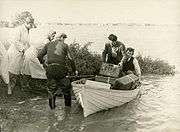
 The Belmont Common was a site of early aviation in the Geelong area. The first person to fly from the Common was Hans Anderson, a garage owner who flew his home made biplane until he crashed the plane at Lovely Banks
.
He was followed by Charles and Percy Pratt. Pilots involved in World War I, they erected a large hangar and workshops, from which they taught gliding and flying, overhauled airplanes and motors, and practised aerial photography
.
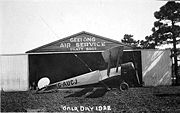
In 1928, 10,000 Geelong residents turned up at the aerodrome to welcome aviator Bert Hinkler
who had just completed a 16-day England-Australia flight. Percy Pratt started the Geelong Gliding Club in 1929 which still exists at Bacchus Marsh
. On 4 August 1937 Percy Pratt took off from the Common and completed the longest towed glider
flight in Australia up to that time.
Avro Anson
bombers used by Bass Island Airways on the run to King Island were housed and serviced at the Belmont Common, one being destroyed by floods in 1952. By the early 1950s the aerodrome on the Common had closed.
tourist railway operated on the Belmont Common from 1969 to 1976. Operated by the Australian Railway Historical Society
's Geelong division under the Geelong Steam Preservation Society name, the railway started with 100 feet (30.5 m) of track and two steam locomotives donated by the Australian Portland Cement company, once used on their private industrial railway at Fyansford
.
Further rolling stock was acquired throughout the 1970s, with plans drawn up for track extension though the Common, and all the way along the Barwon River
to Buckleys Falls. However the mid 1970s regular flooding had dampened enthusiasm, and the construction of the Princes Highway
bypass of Belmont would cut the current railway line in half. At the same time, the closure of the Victorian Railway's Queenscliff
line presented an opportunity for the society, which relocated to Queenscliff in 1976, where it now operates at the Bellarine Peninsula Railway.
to the north and east, Waurn Ponds Creek to the south, and the former Kardinia Creek to the west, which was placed underground in the 1960s. Low lying lands follow the banks of the Barwon River. Further parklands follow the Waurn Ponds Creek.
The area of Belmont Common is flood-prone
during heavy rainfall. It was also a site of early aviation in the area and a flying school was operated in the area in the 1920s. During 1952, the Barwon River broke its banks, flooding the entire Belmont Common area; flooding covering the same area, including the caravan park and K-mart
car park is not uncommon in recent history (1995).
The older populated areas of the suburb are located on top of a hill centred upon High and Regent Streets, overlooking the river and the rest of Geelong. The area near Reynolds Road and High Street are much flatter, and were developed during the post war period. The lower lying areas near Torquay Road were settled from the 1970s onward.
The average household size was 2.3 persons, with the majority of dwellings being separate houses. Family households occupied 60% of private dwellings, with lone person households making up 32%. The median weekly family income was $1,053, compared with $1,171 in Australia.
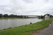
in Belmont, running from the centre of Geelong towards Colac
. A four lane bridge over the Barwon River links Belmont to the north and the rest of Geelong. Once part of the Princes Highway
, a bypass of Belmont was commenced during the early 1980s. Completed in 1990, the four lane James Harrison
Bridge over the Barwon River
removed heavy through traffic from the main shopping centre and diverted traffic down an upgraded Settlement Road. The Princes Highway remains on this route today until the opening of the Geelong Ring Road.
Other major roads include the Surfcoast Highway which runs from Settlement Road south to Grovedale and Torquay
before forming the Great Ocean Road
. Barwon Heads Road which forms an important link to Barwon Heads and other smaller coastal towns. Shannon Avenue which provided a northerly connection to the rest of Geelong, and Barrabool Road which runs west to Highton
and Wandana Heights
.
The line was single track, except for a one crossing loop near the river bridge, and a second south of Mount Pleasant Road. In 1951 4 trams per hour operated over the line during peak times. The line was the last of Geelong tramways to close, the last run being operated on 25 March 1956. Buses replaced the services.
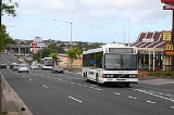
Today Belmont is served by a number of bus routes operated by Benders Busways
that link the suburb with the city, Highton
and Grovedale
. All routes run into the suburb via High Street, before splitting off to various destinations. Bus services to Torquay
also stop in Belmont to pick up passengers, as do V/Line
road coaches to Lorne
and Apollo Bay
.
Belmont was once home of the South Barwon Technical School on Reynolds Road which opened in the late 1970s. The school was closed in the early 1990s as part of the then-State Government reforms of vocational education
. The buildings are now occupied by Clairvaux Catholic Primary School.
A number of kindergartens are also located in Belmont.
The extensive Belmont Common area follows the Barwon River to the east of the suburb, and has a path along both sides of the river for people to utilise on foot or bicycle. The Common also houses the Barwon Valley Public Golf Course
, golf driving range
, a number of baseball fields, motocross
course, indoor and outdoor shooting
ranges, dog obedience school, and cricket
and football ovals.
Further major reserves are Winter Reserve and McDonald Reserve. Established in the late 1960s, both reserves have a number of ovals that see heavy use during the football and cricket seasons.
The suburb has an Australian Rules football team, South Barwon Swans, competing in the Geelong Football League
and the Belmont Lions team competing in the Geelong & District Football League
.
The Barwon Valley Activity Centre houses indoor basketball and netball courts. The centre is also home to a Sunday market
and a number of special events.
Sporting clubs include:
The Leisurelink Swimming Complex houses an enclosed 25 metre swimming pool
, a number of smaller pools, four external waterslides, and a gym and aerobics centre. The ageing centre was replaced with a large $31million centre in Waurn Ponds
in September, 2010.
Next door to Leisurelink is the Geelong Bowling Lanes. Opened in the 1980s, for a number of years it was the only tenpin bowling lanes in Geelong.
Belmont has a number of children's playgrounds throughout the suburb, the major one being the Barwon Valley Fun Park.
The Geelong RSL
clubrooms are located on Barwon Heads Road, relocating from the city in the early 1990s.
Four Scout
Groups were once based in Belmont - 1st and 3rd Belmont at a hall in Rugby Street, and 2nd and 4th Belmont in Dean Street. Only the 1st Belmont Group remains today.
Victoria (Australia)
Victoria is the second most populous state in Australia. Geographically the smallest mainland state, Victoria is bordered by New South Wales, South Australia, and Tasmania on Boundary Islet to the north, west and south respectively....
, Australia. The name means "beautiful hill". Belmont is geographically separated from the Geelong central business district by the Barwon River
Barwon River (Victoria)
The Barwon River rises in the Otway Ranges of Victoria, Australia, runs through Winchelsea and the city of Geelong, where it is joined by the Moorabool River, and enters the sea at Barwon Heads after passing through Lake Connewarre on the Bellarine Peninsula...
. The suburb is primarily residential, with some light industry along Barwon Heads Road. The suburb is part of the City of Greater Geelong
City of Greater Geelong
The City of Greater Geelong is a Local Government Area in Victoria, Australia.It is located in the western part of the state, south-west of Melbourne. It has an area of 1,240 square kilometres. In 2006 it had a population of 191,000...
local government area.
1800s
The area was settled by Geelong mayor Dr. Alexander ThomsonAlexander Thomson (pioneer)
Dr. Alexander Thomson was elected as the first mayor of Geelong and held the position on five occasions from 1850 - 1858...
in 1836 his pastoral run and subsequent purchases of crown land were managed from the homestead Kardinia. Early settlement was hampered by the lack of a secure bridge. By the mid-to-late 1850s a township had developed with a general store and a number of pubs. The Post Office opened on 21 January 1860.
Many of the streets in the area are named after early properties; for instance Roslyn Road was originally a track which led to the homestead Roslyn in the suburb of Wandana. A few significant older buildings remain, such as Royd Grange which was built by Godfrey Hirst in 1897.
In 1850 Dr. Alexander Thomson
Alexander Thomson
Alexander "Greek" Thomson was an eminent Scottish architect and architectural theorist who was a pioneer in sustainable building. Although his work was published in the architectural press of his day, it was little appreciated outwith Glasgow during his lifetime...
offered for sale 93 allotments as the township of Belmont between Mount Pleasant and Roslyn Roads. Further land sales occurred in 1886, 25 acres (101,171.5 m²) of Crown land was offered for sale in 25 allotments. The economic depression of the 1890s adversely affected land sales.
1900s
Geelong Grammar School
Geelong Grammar School is an independent, Anglican, co-educational, boarding and day school. The school's main campus is located at Corio, on the northern outskirts of Geelong, Victoria, Australia, overlooking Corio Bay and Limeburners Bay....
. On 21 October 1910, Chairman of the school, W.T. Manifold turned the first sod that was expected to be the new era of the school. These plans had faded by August 1911, when adjoining rural land was offered for sale as the Belmont Hill Estate. The Grammar School council indicated that an adjacent suburban subdivision would work against their plans for a boarding school, not one catering for day boys. The school made the decision to buy land on the opposite side of Geelong at Corio
Corio, Victoria
Corio is a residential, industrial and one of the largest suburbs of Geelong, Victoria, Australia, located approximately 9 km north of the Geelong central business district...
, with the land at Belmont, sold for further residential subdivision.
The immediate years after the First World War in the early 1920s witnessed the transformation of the rural farmland in Belmont into a residential area. On 6 December 1913, 86 residential sites were auctioned, forming the Belmont Heights Estate. The streets of this new estate were named after well-known Polar explorers: Scott
Robert Falcon Scott
Captain Robert Falcon Scott, CVO was a Royal Navy officer and explorer who led two expeditions to the Antarctic regions: the Discovery Expedition, 1901–04, and the ill-fated Terra Nova Expedition, 1910–13...
, Shackleton
Ernest Shackleton
Sir Ernest Henry Shackleton, CVO, OBE was a notable explorer from County Kildare, Ireland, who was one of the principal figures of the period known as the Heroic Age of Antarctic Exploration...
, Peary
Robert Peary
Robert Edwin Peary, Sr. was an American explorer who claimed to have been the first person, on April 6, 1909, to reach the geographic North Pole...
and Amundsen
Roald Amundsen
Roald Engelbregt Gravning Amundsen was a Norwegian explorer of polar regions. He led the first Antarctic expedition to reach the South Pole between 1910 and 1912 and he was the first person to reach both the North and South Poles. He is also known as the first to traverse the Northwest Passage....
. Further subdivision occurred in the 1920s, stimulated by the construction of a new bridge over the Barwon River
Barwon River (Victoria)
The Barwon River rises in the Otway Ranges of Victoria, Australia, runs through Winchelsea and the city of Geelong, where it is joined by the Moorabool River, and enters the sea at Barwon Heads after passing through Lake Connewarre on the Bellarine Peninsula...
in 1926, and the extension of the Geelong tram
Tram
A tram is a passenger rail vehicle which runs on tracks along public urban streets and also sometimes on separate rights of way. It may also run between cities and/or towns , and/or partially grade separated even in the cities...
way system in 1927. Construction of houses started during the interwar and early postwar years, most built as affordable homes for textile workers, drivers, labourers, clerks, secretaries, teachers and builders.
Major housing development of Belmont commenced in the years following World War II, with housing developments spreading from the original township on the hill, westwards towards Highton
Highton, Victoria
Highton is a residential suburb of Geelong, Victoria, Australia. It is bordered by the Barrabool Hills and Wandana Heights to the west, the Barwon River to the north and east, the former Kardinia Creek to the south-east, and the Princes Highway and Pigdons Road to the south.-History:Grazier John...
. Later development in the 1970s saw subdivision to the south towards Grovedale
Grovedale, Victoria
Grovedale is a mainly residential southern suburb of Geelong, Victoria, Australia.The suburb is bounded by the Waurn Ponds Creek, Rossack Drive, Boundary Road and Barwarre Road.-Toponomy:...
.
The CSIRO established laboratories in Belmont in 1948 to perform research to support the wool industry, it has since become one of the leading textile research centres in the world.
Aviation
Lovely Banks, Victoria
Lovely Banks is a northern suburb of Geelong, Victoria, Australia. Once an agricultural and rural area, the suburb is quickly developing into a residential area adjoining the Geelong suburbs of Bell Park, Corio and Norlane....
.
He was followed by Charles and Percy Pratt. Pilots involved in World War I, they erected a large hangar and workshops, from which they taught gliding and flying, overhauled airplanes and motors, and practised aerial photography
Aerial photography
Aerial photography is the taking of photographs of the ground from an elevated position. The term usually refers to images in which the camera is not supported by a ground-based structure. Cameras may be hand held or mounted, and photographs may be taken by a photographer, triggered remotely or...
.
In 1928, 10,000 Geelong residents turned up at the aerodrome to welcome aviator Bert Hinkler
Bert Hinkler
Herbert John Louis Hinkler AFC DSM , better known as Bert Hinkler, was a pioneer Australian aviator and inventor. He designed and built early aircraft before being the first person to fly solo from England to Australia, and the first person to fly solo across the Southern Atlantic Ocean...
who had just completed a 16-day England-Australia flight. Percy Pratt started the Geelong Gliding Club in 1929 which still exists at Bacchus Marsh
Bacchus Marsh, Victoria
Bacchus Marsh is an urban centre and suburban locality in Victoria, Australia located approximately west of Melbourne and west of Melton. The population of the urban area is estimated at over 17,000 people, while the central locality is home to 5,566 people...
. On 4 August 1937 Percy Pratt took off from the Common and completed the longest towed glider
Glider aircraft
Glider aircraft are heavier-than-air craft that are supported in flight by the dynamic reaction of the air against their lifting surfaces, and whose free flight does not depend on an engine. Mostly these types of aircraft are intended for routine operation without engines, though engine failure can...
flight in Australia up to that time.
Avro Anson
Avro Anson
The Avro Anson is a British twin-engine, multi-role aircraft that served with the Royal Air Force, Fleet Air Arm and numerous other air forces prior to, during, and after the Second World War. Named for British Admiral George Anson, it was originally designed for maritime reconnaissance, but was...
bombers used by Bass Island Airways on the run to King Island were housed and serviced at the Belmont Common, one being destroyed by floods in 1952. By the early 1950s the aerodrome on the Common had closed.
Railway
A narrow gaugeNarrow gauge
A narrow gauge railway is a railway that has a track gauge narrower than the of standard gauge railways. Most existing narrow gauge railways have gauges of between and .- Overview :...
tourist railway operated on the Belmont Common from 1969 to 1976. Operated by the Australian Railway Historical Society
Australian Railway Historical Society
The Australian Railway Historical Society was founded in Sydney in 1933 as The Australasian Railway and Locomotive Historical Society. It aims to foster an interest in the railways, and record and preserve many facets of railway operations. Membership now exceeds 2,500, with Divisions in every...
's Geelong division under the Geelong Steam Preservation Society name, the railway started with 100 feet (30.5 m) of track and two steam locomotives donated by the Australian Portland Cement company, once used on their private industrial railway at Fyansford
Fyansford, Victoria
Fyansford is a township on the western edge of Geelong, Victoria, Australia, named after Captain Foster Fyans who came to Geelong as a Police magistrate in October, 1837. It is located at the junction of the Barwon and Moorabool rivers....
.
Further rolling stock was acquired throughout the 1970s, with plans drawn up for track extension though the Common, and all the way along the Barwon River
Barwon River (Victoria)
The Barwon River rises in the Otway Ranges of Victoria, Australia, runs through Winchelsea and the city of Geelong, where it is joined by the Moorabool River, and enters the sea at Barwon Heads after passing through Lake Connewarre on the Bellarine Peninsula...
to Buckleys Falls. However the mid 1970s regular flooding had dampened enthusiasm, and the construction of the Princes Highway
Princes Highway
The Princes Highway extends from Sydney to Port Augusta via the coast through the states of New South Wales, Victoria and South Australia, a distance of 1941 km or 1898 km via the former alignments of the highway ....
bypass of Belmont would cut the current railway line in half. At the same time, the closure of the Victorian Railway's Queenscliff
Queenscliff, Victoria
Queenscliff is a small town on the Bellarine Peninsula in southern Victoria, Australia, south of Swan Bay at the entrance to Port Phillip. It is the administrative centre for the Borough of Queenscliffe...
line presented an opportunity for the society, which relocated to Queenscliff in 1976, where it now operates at the Bellarine Peninsula Railway.
Geography
Belmont is bounded by the Barwon RiverBarwon River (Victoria)
The Barwon River rises in the Otway Ranges of Victoria, Australia, runs through Winchelsea and the city of Geelong, where it is joined by the Moorabool River, and enters the sea at Barwon Heads after passing through Lake Connewarre on the Bellarine Peninsula...
to the north and east, Waurn Ponds Creek to the south, and the former Kardinia Creek to the west, which was placed underground in the 1960s. Low lying lands follow the banks of the Barwon River. Further parklands follow the Waurn Ponds Creek.
The area of Belmont Common is flood-prone
Flood
A flood is an overflow of an expanse of water that submerges land. The EU Floods directive defines a flood as a temporary covering by water of land not normally covered by water...
during heavy rainfall. It was also a site of early aviation in the area and a flying school was operated in the area in the 1920s. During 1952, the Barwon River broke its banks, flooding the entire Belmont Common area; flooding covering the same area, including the caravan park and K-mart
Kmart Australia
Kmart Australia Limited is a discount department store chain owned by Wesfarmers. It operates 172 stores in Australia and 15 in New Zealand, with its head office located in Mulgrave, Victoria. Wesfarmers uses the Kmart name under licence from Sears Holdings Corporation.-History:Kmart Australia...
car park is not uncommon in recent history (1995).
The older populated areas of the suburb are located on top of a hill centred upon High and Regent Streets, overlooking the river and the rest of Geelong. The area near Reynolds Road and High Street are much flatter, and were developed during the post war period. The lower lying areas near Torquay Road were settled from the 1970s onward.
Demographics
In the 2006 census, 13,646 persons resided in Belmont. 16% of the population were children aged between 0–14 years, and 31% were aged 55 years and over. Belmont is an ageing suburb, with the median age of residents being 40 years, compared with 37 years for persons in Australia. 90% of residents are Australian citizens with 80.3% born in Australia, the most common foreign birthplace being England (3.6%).The average household size was 2.3 persons, with the majority of dwellings being separate houses. Family households occupied 60% of private dwellings, with lone person households making up 32%. The median weekly family income was $1,053, compared with $1,171 in Australia.
Transportation
Roads
High Street is the main roadRoad
A road is a thoroughfare, route, or way on land between two places, which typically has been paved or otherwise improved to allow travel by some conveyance, including a horse, cart, or motor vehicle. Roads consist of one, or sometimes two, roadways each with one or more lanes and also any...
in Belmont, running from the centre of Geelong towards Colac
Colac, Victoria
Colac is a small city located in the Western District of Victoria, Australia, situated approximately 150 kilometres south-west of Melbourne on the southern shore of Lake Colac and the surrounding volcanic plains, approximately 40 km inland from Bass Strait. Colac is the largest city in and...
. A four lane bridge over the Barwon River links Belmont to the north and the rest of Geelong. Once part of the Princes Highway
Princes Highway
The Princes Highway extends from Sydney to Port Augusta via the coast through the states of New South Wales, Victoria and South Australia, a distance of 1941 km or 1898 km via the former alignments of the highway ....
, a bypass of Belmont was commenced during the early 1980s. Completed in 1990, the four lane James Harrison
James Harrison (engineer)
James Harrison was an Australian newspaper printer, journalist, politician, and pioneer in the field of mechanical refrigeration.-Early life:...
Bridge over the Barwon River
Barwon River (Victoria)
The Barwon River rises in the Otway Ranges of Victoria, Australia, runs through Winchelsea and the city of Geelong, where it is joined by the Moorabool River, and enters the sea at Barwon Heads after passing through Lake Connewarre on the Bellarine Peninsula...
removed heavy through traffic from the main shopping centre and diverted traffic down an upgraded Settlement Road. The Princes Highway remains on this route today until the opening of the Geelong Ring Road.
Other major roads include the Surfcoast Highway which runs from Settlement Road south to Grovedale and Torquay
Torquay
Torquay is a town in the unitary authority area of Torbay and ceremonial county of Devon, England. It lies south of Exeter along the A380 on the north of Torbay, north-east of Plymouth and adjoins the neighbouring town of Paignton on the west of the bay. Torquay’s population of 63,998 during the...
before forming the Great Ocean Road
Great Ocean Road
The Great Ocean Road is a stretch of road along the south-eastern coast of Australia between the Victorian cities of Torquay and Warrnambool. The road was built by returned soldiers between 1919 and 1932, and is the world's largest war memorial; dedicated to casualties of World War I...
. Barwon Heads Road which forms an important link to Barwon Heads and other smaller coastal towns. Shannon Avenue which provided a northerly connection to the rest of Geelong, and Barrabool Road which runs west to Highton
Highton, Victoria
Highton is a residential suburb of Geelong, Victoria, Australia. It is bordered by the Barrabool Hills and Wandana Heights to the west, the Barwon River to the north and east, the former Kardinia Creek to the south-east, and the Princes Highway and Pigdons Road to the south.-History:Grazier John...
and Wandana Heights
Wandana Heights, Victoria
Wandana Heights is a residential suburb of Geelong, Victoria, Australia. Suburban development of the suburb commenced in the 1980s which due to the current high property prices in Australia, and the fluctuation of prices in previous years housing development has been sporadic with periods where...
.
Trams
Trams served Belmont from 1927 to 1956. The tramline was opened on 16 December 1927 when the 'South' route was extended from the Barwon Bridge to Colac Road. The extension was made possible by the construction of a new wider bridge over the Barwon the same year. The tram line ran along High Street to the terminus on the corner of Roslyn Road.The line was single track, except for a one crossing loop near the river bridge, and a second south of Mount Pleasant Road. In 1951 4 trams per hour operated over the line during peak times. The line was the last of Geelong tramways to close, the last run being operated on 25 March 1956. Buses replaced the services.
Buses
A motor bus service to Belmont commenced on 15 January 1914. Using 12 hp double decker buses capable of travelling at 12 miles (19.3 km) an hour (19 km/h), they were later replaced by the tram service.Today Belmont is served by a number of bus routes operated by Benders Busways
Benders Busways
Benders Busways is a privately owned transport company in Geelong, Victoria. It operates a number of public transport routes in Geelong under the Geelong Transit System umbrella, as well as bus charter work, and is part of the ComfortDelGro Cabcharge group....
that link the suburb with the city, Highton
Highton, Victoria
Highton is a residential suburb of Geelong, Victoria, Australia. It is bordered by the Barrabool Hills and Wandana Heights to the west, the Barwon River to the north and east, the former Kardinia Creek to the south-east, and the Princes Highway and Pigdons Road to the south.-History:Grazier John...
and Grovedale
Grovedale, Victoria
Grovedale is a mainly residential southern suburb of Geelong, Victoria, Australia.The suburb is bounded by the Waurn Ponds Creek, Rossack Drive, Boundary Road and Barwarre Road.-Toponomy:...
. All routes run into the suburb via High Street, before splitting off to various destinations. Bus services to Torquay
Torquay, Victoria
Torquay is a township in Victoria, Australia, which faces Bass Strait, 21 km. south of Geelong and is the gateway to the Great Ocean Road. It is bordered on the west by Spring Creek and its coastal features include Point Danger and Zeally Bay...
also stop in Belmont to pick up passengers, as do V/Line
V/Line
V/Line is a not for profit regional passenger train and coach service in Victoria, Australia. It was created after the split-up of VicRail in 1983. V/Line is owned by the V/Line Corporation which is a Victorian State Government statutory authority...
road coaches to Lorne
Lorne, Victoria
Lorne is a seaside town on Louttit Bay in Victoria, Australia. It is situated about the Erskine River and is a popular destination on the Great Ocean Road tourist route...
and Apollo Bay
Apollo Bay, Victoria
Apollo Bay is a coastal town in southwestern Victoria, Australia. It is situated on the eastern side of Cape Otway, along the edge of the Barham River and on the Great Ocean Road, in the Colac Otway Shire. The town has a population of 1380....
.
Shopping
The High Street shopping strip is the largest strip shopping centre in Geelong, stretching from Barwon Heads Road to Roslyn Road. The shopping strip was upgraded in 2006. .Education
Belmont is served by a number of Primary and Secondary schools:- Belmont Primary School was the first primary school in the suburb, opened on 1 December 1856. Located on Mount Pleasant Road, the school suffered from declining enrolment during the 1990s but has stabilised .
- St Bernards Catholic Primary School was the school of the St Bernards Catholic parishParishA parish is a territorial unit historically under the pastoral care and clerical jurisdiction of one parish priest, who might be assisted in his pastoral duties by a curate or curates - also priests but not the parish priest - from a more or less central parish church with its associated organization...
. Located on the corner of High and Regent Streets, the school was merged with HightonHighton, VictoriaHighton is a residential suburb of Geelong, Victoria, Australia. It is bordered by the Barrabool Hills and Wandana Heights to the west, the Barwon River to the north and east, the former Kardinia Creek to the south-east, and the Princes Highway and Pigdons Road to the south.-History:Grazier John...
's Mercia Catholic Primary School in 1999, to form Clairvaux Catholic Primary School on Reynolds Road. - Belmont High School is situated off Roslyn Road, and was the first secondary school in Belmont. It opened during the post war population boom in the district.
- Roslyn Primary School opening about the same time.
- Oberon Primary School also opened when Belmont was first being developed post-war.
- Oberon High SchoolOberon High SchoolOberon High School is a secondary school located in Belmont, Geelong, Victoria, Australia . Established in 1963, Oberon High School is a single campus years 7 - 12 school situated in the Geelong suburb of Belmont. It caters for students in Year 7 until Year 12...
opened on Kidman Avenue in the late 1960s to serve the growing population south of the Barwon River. The school also caters for students from the coastal and country areas to the south of Geelong. - Oberon South Primary School is located next to Oberon High School on Tintinara Crescent.
Belmont was once home of the South Barwon Technical School on Reynolds Road which opened in the late 1970s. The school was closed in the early 1990s as part of the then-State Government reforms of vocational education
Vocational education
Vocational education or vocational education and training is an education that prepares trainees for jobs that are based on manual or practical activities, traditionally non-academic, and totally related to a specific trade, occupation, or vocation...
. The buildings are now occupied by Clairvaux Catholic Primary School.
A number of kindergartens are also located in Belmont.
Research Laboratories
The CSIRO Division of Materials Science and Engineering is located on Henry and High Streets.Recreation
Belmont has a large number of reserves and a number of local sporting clubs.The extensive Belmont Common area follows the Barwon River to the east of the suburb, and has a path along both sides of the river for people to utilise on foot or bicycle. The Common also houses the Barwon Valley Public Golf Course
Golf course
A golf course comprises a series of holes, each consisting of a teeing ground, fairway, rough and other hazards, and a green with a flagstick and cup, all designed for the game of golf. A standard round of golf consists of playing 18 holes, thus most golf courses have this number of holes...
, golf driving range
Driving range
A driving range is an area where golfers can practice their swing. It can also be a recreational activity itself for amateur golfers or when enough time for a full game is not available. Many golf courses have a driving range attached and they are also found as stand-alone facilities, especially...
, a number of baseball fields, motocross
Motocross
Motocross is a form of motorcycle sport or all-terrain vehicle racing held on enclosed off road circuits. It evolved from trials, and was called scrambles, and later motocross, combining the French moto with cross-country...
course, indoor and outdoor shooting
Shooting
Shooting is the act or process of firing rifles, shotguns or other projectile weapons such as bows or crossbows. Even the firing of artillery, rockets and missiles can be called shooting. A person who specializes in shooting is a marksman...
ranges, dog obedience school, and cricket
Cricket
Cricket is a bat-and-ball game played between two teams of 11 players on an oval-shaped field, at the centre of which is a rectangular 22-yard long pitch. One team bats, trying to score as many runs as possible while the other team bowls and fields, trying to dismiss the batsmen and thus limit the...
and football ovals.
Further major reserves are Winter Reserve and McDonald Reserve. Established in the late 1960s, both reserves have a number of ovals that see heavy use during the football and cricket seasons.
The suburb has an Australian Rules football team, South Barwon Swans, competing in the Geelong Football League
Geelong Football League
The Geelong Football League is an Australian rules football league in Victoria, Australia. It is the highest quality league in the Geelong area, with numerous former AFL players playing for various clubs.-History:...
and the Belmont Lions team competing in the Geelong & District Football League
Geelong & District Football League
The Geelong & District Football League is the oldest surviving football competition in Victoria . It is one of three Australian rules football leagues in the Geelong area, the others being the Geelong Football League and the Bellarine Football League....
.
The Barwon Valley Activity Centre houses indoor basketball and netball courts. The centre is also home to a Sunday market
Market
A market is one of many varieties of systems, institutions, procedures, social relations and infrastructures whereby parties engage in exchange. While parties may exchange goods and services by barter, most markets rely on sellers offering their goods or services in exchange for money from buyers...
and a number of special events.
Sporting clubs include:
- Geelong Bowls Club
- Geelong Lawn Tennis Club
- Belmont Bowls Club
- Geelong RSL Bowls Club
The Leisurelink Swimming Complex houses an enclosed 25 metre swimming pool
Swimming pool
A swimming pool, swimming bath, wading pool, or simply a pool, is a container filled with water intended for swimming or water-based recreation. There are many standard sizes; the largest is the Olympic-size swimming pool...
, a number of smaller pools, four external waterslides, and a gym and aerobics centre. The ageing centre was replaced with a large $31million centre in Waurn Ponds
Waurn Ponds, Victoria
Waurn Ponds is a mainly residential southern suburb of Geelong, Victoria, Australia.The suburb is bounded by Rossack Drive, Princes Highway, the Geelong to Warnambool railway, Reservoir Road, Draytons Road, Pigdons Road, Deakin University and Honeys Road....
in September, 2010.
Next door to Leisurelink is the Geelong Bowling Lanes. Opened in the 1980s, for a number of years it was the only tenpin bowling lanes in Geelong.
Belmont has a number of children's playgrounds throughout the suburb, the major one being the Barwon Valley Fun Park.
Community
The Belmont Senior Citizens centre is located on Thompson Street behind the High Street shopping strip.The Geelong RSL
Returned and Services League of Australia
The Returned and Services League of Australia is a support organisation for men and women who have served or are serving in the Australian Defence Force ....
clubrooms are located on Barwon Heads Road, relocating from the city in the early 1990s.
Four Scout
Scouting
Scouting, also known as the Scout Movement, is a worldwide youth movement with the stated aim of supporting young people in their physical, mental and spiritual development, that they may play constructive roles in society....
Groups were once based in Belmont - 1st and 3rd Belmont at a hall in Rugby Street, and 2nd and 4th Belmont in Dean Street. Only the 1st Belmont Group remains today.