
Grovedale, Victoria
Encyclopedia
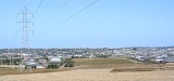
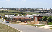
Grovedale is a mainly residential southern suburb
of Geelong, Victoria
, Australia
.
The suburb is bounded by the Waurn Ponds Creek, Rossack Drive, Boundary Road and Barwarre Road.
In September 1915, after the outbreak of the first world war, the South Barwon Council changed the named to Grovedale - the name of a nearby property bought by Alexander Pennell in 1847. The Post Office was renamed on 1 March 1916.
There were also two hotels, two flour mills, two tanneries and four wool-washing businesses.
The hilly country and volcanic soil were ideal for orchards and vineyards. The area earned a significant reputation for its bad smell and was Victoria's largest wine-producing region, thanks to the efforts of Swiss migrants.
 Residential expansion commenced in Grovedale in the late 1960s, the first housing estates branching off the Surfcoast Highway. Later expansion throughout the 1970s to the 1990s moved to the west along Church Street, Pioneer Road, and Heyers Road.
A Grovedale East Post Office opened in 1996 near the Surf Coast Highway.
By 2010 development had commenced on the last clear land on the eastern side of the highway, with that part of Grovedale now approaching full development. The section of the locality south of the Warrnambool railway line is part of the large Armstrong Creek Growth Area
with development beginning in 2010.
. Pioneer Road runs east west though Grovedale, the road not being completed eastward across the Waurn Ponds Creek until the late 1980s.
Public transport to the area is provided by bus
es operated by Benders Buslines and McHarrys Buslines, on routes to the Geelong city centre travelling via Deakin University
, Belmont
, Highton
and Waurn Ponds
.
The 2003–04 Victorian State Budget saw funding made available for an extension of rail services on the line between Melbourne and Geelong southwards to Grovedale. A number of options were examined, among them a new railway station at Grovedale on the Surfcoast HIghway. Marshall station was opened in 2005 just outside Grovedale on the site of a closed station.
.
Suburb
The word suburb mostly refers to a residential area, either existing as part of a city or as a separate residential community within commuting distance of a city . Some suburbs have a degree of administrative autonomy, and most have lower population density than inner city neighborhoods...
of Geelong, Victoria
Victoria (Australia)
Victoria is the second most populous state in Australia. Geographically the smallest mainland state, Victoria is bordered by New South Wales, South Australia, and Tasmania on Boundary Islet to the north, west and south respectively....
, Australia
Australia
Australia , officially the Commonwealth of Australia, is a country in the Southern Hemisphere comprising the mainland of the Australian continent, the island of Tasmania, and numerous smaller islands in the Indian and Pacific Oceans. It is the world's sixth-largest country by total area...
.
The suburb is bounded by the Waurn Ponds Creek, Rossack Drive, Boundary Road and Barwarre Road.
Toponomy
It was originally named Germantown due to several families of Lutheran German origin who arrived in 1849 and the community expanded during the 1860s.In September 1915, after the outbreak of the first world war, the South Barwon Council changed the named to Grovedale - the name of a nearby property bought by Alexander Pennell in 1847. The Post Office was renamed on 1 March 1916.
Settlement
A Post Office had opened on 21 January 1860.There were also two hotels, two flour mills, two tanneries and four wool-washing businesses.
The hilly country and volcanic soil were ideal for orchards and vineyards. The area earned a significant reputation for its bad smell and was Victoria's largest wine-producing region, thanks to the efforts of Swiss migrants.
Postwar housing boom
A Grovedale East Post Office opened in 1996 near the Surf Coast Highway.
By 2010 development had commenced on the last clear land on the eastern side of the highway, with that part of Grovedale now approaching full development. The section of the locality south of the Warrnambool railway line is part of the large Armstrong Creek Growth Area
Armstrong Creek Growth Area
The Armstrong Creek Growth Area is the southern extension to the urban growth boundary of the metropolitan area of Geelong, Victoria, Australia. It comprises parts of the localities of Grovedale and Marshall south of the Warrnambool railway line, and parts of the localities of Mount Duneed and...
with development beginning in 2010.
Transport
Grovedale is located on the Surfcoast Highway that links the suburb the centre of Geelong, as well as to the coastal town of TorquayTorquay, Victoria
Torquay is a township in Victoria, Australia, which faces Bass Strait, 21 km. south of Geelong and is the gateway to the Great Ocean Road. It is bordered on the west by Spring Creek and its coastal features include Point Danger and Zeally Bay...
. Pioneer Road runs east west though Grovedale, the road not being completed eastward across the Waurn Ponds Creek until the late 1980s.
Public transport to the area is provided by bus
Bus
A bus is a road vehicle designed to carry passengers. Buses can have a capacity as high as 300 passengers. The most common type of bus is the single-decker bus, with larger loads carried by double-decker buses and articulated buses, and smaller loads carried by midibuses and minibuses; coaches are...
es operated by Benders Buslines and McHarrys Buslines, on routes to the Geelong city centre travelling via Deakin University
Deakin University
Deakin University is an Australian public university with nearly 40,000 higher education students in 2010. It receives more than A$600 million in operating revenue annually, and controls more than A$1.3 billion in assets. It received more than A$35 million in research income in 2009 and had 835...
, Belmont
Belmont, Victoria
Belmont is a southern suburb of Geelong, Victoria, Australia. The name means "beautiful hill". Belmont is geographically separated from the Geelong central business district by the Barwon River. The suburb is primarily residential, with some light industry along Barwon Heads Road...
, Highton
Highton, Victoria
Highton is a residential suburb of Geelong, Victoria, Australia. It is bordered by the Barrabool Hills and Wandana Heights to the west, the Barwon River to the north and east, the former Kardinia Creek to the south-east, and the Princes Highway and Pigdons Road to the south.-History:Grazier John...
and Waurn Ponds
Waurn Ponds, Victoria
Waurn Ponds is a mainly residential southern suburb of Geelong, Victoria, Australia.The suburb is bounded by Rossack Drive, Princes Highway, the Geelong to Warnambool railway, Reservoir Road, Draytons Road, Pigdons Road, Deakin University and Honeys Road....
.
The 2003–04 Victorian State Budget saw funding made available for an extension of rail services on the line between Melbourne and Geelong southwards to Grovedale. A number of options were examined, among them a new railway station at Grovedale on the Surfcoast HIghway. Marshall station was opened in 2005 just outside Grovedale on the site of a closed station.
Sport
The town has an Australian Rules football team competing in the Geelong Football LeagueGeelong Football League
The Geelong Football League is an Australian rules football league in Victoria, Australia. It is the highest quality league in the Geelong area, with numerous former AFL players playing for various clubs.-History:...
.