
.gif)
Barwon River (Victoria)
Encyclopedia
- For other uses, see Barwon RiverBarwon RiverBarwon River may refer to:* Barwon River , Australia* Barwon River , Australia...
.
The Barwon River rises in the Otway Ranges of Victoria
Victoria (Australia)
Victoria is the second most populous state in Australia. Geographically the smallest mainland state, Victoria is bordered by New South Wales, South Australia, and Tasmania on Boundary Islet to the north, west and south respectively....
, Australia
Australia
Australia , officially the Commonwealth of Australia, is a country in the Southern Hemisphere comprising the mainland of the Australian continent, the island of Tasmania, and numerous smaller islands in the Indian and Pacific Oceans. It is the world's sixth-largest country by total area...
, runs through Winchelsea
Winchelsea, Victoria
Winchelsea is a town in Victoria, Australia. It is in the Surf Coast Shire local government area and located on the Barwon River 115 km south-west of Melbourne and close to Geelong .- History :...
and the city of Geelong, where it is joined by the Moorabool River
Moorabool River
The Moorabool River is a river in Victoria, Australia that runs past several small towns and areas such as Meredith, Anakie, and Staughton Vale...
, and enters the sea at Barwon Heads
Barwon Heads, Victoria
Barwon Heads is a coastal township on the Bellarine Peninsula, near Geelong, Victoria, Australia. It is situated on the west bank of the mouth of the Barwon River below Lake Connewarre, while it is bounded to the west by farmland, golf courses and the ephemeral saline wetland Murtnaghurt...
after passing through Lake Connewarre
Lake Connewarre
Lake Connewarre is a shallow estuarine lake located on the Barwon River, on the Bellarine Peninsula near Geelong, Victoria. It is adjacent to, and downstream from, the freshwater Reedy Lake...
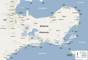
on the Bellarine Peninsula
Bellarine Peninsula
The Bellarine Peninsula is a peninsula located south-west of Melbourne in Victoria, Australia, surrounded by Port Phillip, Corio Bay and Bass Strait. The peninsula, together with the Mornington Peninsula separates Port Phillip from Bass Strait...
. The estuarine section of the river forms part of the Port Phillip (Western Shoreline) and Bellarine Peninsula Ramsar Site as a wetland of international importance.
The river is crossed by a number of bridges in Geelong. Of particular note is the unusual one lane truss bridge in Newtown
Newtown, Victoria
Newtown is an inner western suburb of Geelong, Victoria, Australia. It is a primarily residential area occupying one of the highest points of urban Geelong, has always been a desirable place of residence and it is the location of many of Geelong's oldest and most valuable properties.The locality of...
, Geelong. The 'Breakwater' in East Geelong was constructed by Foster Fyans
Foster Fyans
Foster Fyans , soldier, penal administrator and public servant, was acting commandant of the second convict settlement at Norfolk Island, the first police magistrate at Geelong, and commissioner of crown lands for the Portland Bay pastoral district in the Port Phillip District of New South...
to supply drinking water.
Water from the river feeds agriculture and industry. The river is a popular recreation spot for Geelong, with parklands such as Balyang Sanctuary
Balyang Sanctuary
Balyang Sanctuary is a public park in the suburb of Newtown, Geelong. Situated at on the banks of the Barwon River, it is in size and consists of open park lands, lakes, and wetlands. It was opened in 1973.-History:...
along the banks, and sees use by water ski
Water skiing
thumb|right|A slalom skier making a turn on a slalom waterski.Waterskiing is a sport where an individual is pulled behind a boat or a cable ski installation on a body of water, skimming the surface.-History:...
ers and rowing regatti such as Head of the River
Head of the River (Victoria)
The Victorian Head of the River regatta is contested between the eleven Associated Public Schools of Victoria .The race is usually the last race of the official APS rowing season and has recently been rowed on Lake Nagambie which is a full buoyed international standard course allowing six boat...
.
Towns
- ForrestForrest, VictoriaForrest, Victoria is a small rural township located in the Otway Ranges. At the 2006 census, Forrest and the surrounding area had a population of 170.-History:...
- Barwon DownsBarwon DownsBarwon Downs is a town in Victoria, Australia. The town is located in the foothills of the Otway Ranges, south west of the state capital, Melbourne. The township was proclaimed on 10 May 1910. At the 2006 census, Barwon Downs had a population of 167....
- BirregurraBirregurra, VictoriaBirregurra is a town in Victoria, Australia approximately 130 km south-west of Melbourne. At the 2006 census, Birregurra had a population of 688....
- WinchelseaWinchelsea, VictoriaWinchelsea is a town in Victoria, Australia. It is in the Surf Coast Shire local government area and located on the Barwon River 115 km south-west of Melbourne and close to Geelong .- History :...
- InverleighInverleigh, VictoriaInverleigh is a small rural township in Victoria, Australia located west from the City of Geelong and from the state capital, Melbourne. At the 2006 census, Inverleigh had a population of 562....
- Geelong
- Ocean GroveOcean Grove, VictoriaOcean Grove is a seaside town in Victoria, Australia, located on the Bellarine Peninsula. At the 2006 census, Ocean Grove had a population of 11,274.-History:...
- Barwon HeadsBarwon Heads, VictoriaBarwon Heads is a coastal township on the Bellarine Peninsula, near Geelong, Victoria, Australia. It is situated on the west bank of the mouth of the Barwon River below Lake Connewarre, while it is bounded to the west by farmland, golf courses and the ephemeral saline wetland Murtnaghurt...
Tributaries
- Leigh River / Yarrowee RiverYarrowee RiverYarrowee is a major tributary and catchment of the Barwon River in Victoria, Australia. The river's origins are in the hills at Gong Gong, and it is notable for passing through the settlement of Ballarat and crossing the City of Ballarat local government area before becoming the Leigh River in the...
, at Inverleigh - Moorabool RiverMoorabool RiverThe Moorabool River is a river in Victoria, Australia that runs past several small towns and areas such as Meredith, Anakie, and Staughton Vale...
, at Fyansford
Highton/Newtown
West Barwon Dam
The West Barwon Dam was constructed near ForrestForrest, Victoria
Forrest, Victoria is a small rural township located in the Otway Ranges. At the 2006 census, Forrest and the surrounding area had a population of 170.-History:...
in 1965 by what is now Barwon Water
Barwon Water
Barwon Water is a government owned statutory authority that controls much of the water system in Geelong, Victoria, Australia including the reservoirs, and the sewerage and drainage system that services the city and surrounding districts...
. The dam is now the major water supply for Geelong.
Buckley's Falls
Buckley's Falls is located between HightonHighton, Victoria
Highton is a residential suburb of Geelong, Victoria, Australia. It is bordered by the Barrabool Hills and Wandana Heights to the west, the Barwon River to the north and east, the former Kardinia Creek to the south-east, and the Princes Highway and Pigdons Road to the south.-History:Grazier John...
and Fyansford
Fyansford, Victoria
Fyansford is a township on the western edge of Geelong, Victoria, Australia, named after Captain Foster Fyans who came to Geelong as a Police magistrate in October, 1837. It is located at the junction of the Barwon and Moorabool rivers....
. A weir and water race was built above the falls in 1876 to provide power for the Fyansford Paper Mill. The falls were named by John Helder Wedge
John Helder Wedge
John Helder Wedge was a surveyor, explorer and politician in Van Diemen's Land .Wedge was the second son of Charles Wedge of Shudy Camps, Cambridge, England. John Wedge learned the basics of surveying from his father...
after escaped convict William Buckley
William Buckley (convict)
William Buckley was an English convict who was transported to Australia, escaped, was given up for dead and lived in an Aboriginal community for many years....
who lived in the area with Aborigines for 32 years from 1803.
The 'Breakwater'
The 'Breakwater' is located in the current Geelong suburb of the same name. Originally built to prevent salt water moving upstream, it now keeps the river level through Geelong constant and is an important crossing point.Construction on the weir
Weir
A weir is a small overflow dam used to alter the flow characteristics of a river or stream. In most cases weirs take the form of a barrier across the river that causes water to pool behind the structure , but allows water to flow over the top...
started in late 1838 under Captain Foster Fyans
Foster Fyans
Foster Fyans , soldier, penal administrator and public servant, was acting commandant of the second convict settlement at Norfolk Island, the first police magistrate at Geelong, and commissioner of crown lands for the Portland Bay pastoral district in the Port Phillip District of New South...
and was completed by May 1840.
Built by convicts, the weir failed in flood in 1844, not being fully rebuilt until 1849. Little changed to the breakwater until it was rebuilt by the Country Roads Board
Country Roads Board
The Country Roads Board was the government authority responsible for the construction and maintenance of main roads in the State of Victoria, Australia between 1913 and 1983. Its first chairman was William Calder who remained in charge until his death in 1928...
for modern traffic in the mid 1960s.
Barrage
A second weirWeir
A weir is a small overflow dam used to alter the flow characteristics of a river or stream. In most cases weirs take the form of a barrier across the river that causes water to pool behind the structure , but allows water to flow over the top...
was built over the Barwon River further downstream. Located near where the river enters Lake Connewarre
Lake Connewarre
Lake Connewarre is a shallow estuarine lake located on the Barwon River, on the Bellarine Peninsula near Geelong, Victoria. It is adjacent to, and downstream from, the freshwater Reedy Lake...
, the barrage again keeps water levels constant upstream for waterskiiers, and prevents saltwater moving upstream into Reedy Lake
Reedy Lake
Reedy Lake, historically also known as Lake Reedy, is a shallow 5.5 km2 freshwater lake or swamp on the lower reaches of the Barwon River, on the Bellarine Peninsula near the city Geelong, Victoria, Australia. It is included in the Lake Connewarre State Game Reserve, which is managed by Parks...
.
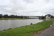
Geelong Ring Road
The Geelong Ring Road bridge carries four lanes of freeway over the river. It is made up of twin 110 metre long bridges, and was completed in 2009.Queens Bridge
The one lane Queens Bridge carries Queens Park Road which links Highton and NewtownNewtown, Victoria
Newtown is an inner western suburb of Geelong, Victoria, Australia. It is a primarily residential area occupying one of the highest points of urban Geelong, has always been a desirable place of residence and it is the location of many of Geelong's oldest and most valuable properties.The locality of...
.
The bridge was first the site of a punt
Punt (boat)
A punt is a flat-bottomed boat with a square-cut bow, designed for use in small rivers or other shallow water. Punting refers to boating in a punt. The punter generally propels the punt by pushing against the river bed with a pole...
, with a wooden cattle crossing not being built until 1861, with those crossing a bridge being charged a toll
Toll bridge
A toll bridge is a bridge over which traffic may pass upon payment of a toll, or fee.- History :The practice of collecting tolls on bridges probably harks back to the days of ferry crossings where people paid a fee to be ferried across stretches of water. As boats became impractical to carry large...
. The bridge collapsed in the 1870 flood, with a new wooden bridge opened in 1872. The toll ended 1877. The bridge remained until wrecked by the 1909 flood, but was rebuilt.
The current one lane steel bridge was built in 1930, a water main and footpath being added to the side in 1963, and the height and deck modified in later years. The bridge is still in use today.
Princes Bridge
The two lane Princes Bridge carries Shannon Avenue between BelmontBelmont, Victoria
Belmont is a southern suburb of Geelong, Victoria, Australia. The name means "beautiful hill". Belmont is geographically separated from the Geelong central business district by the Barwon River. The suburb is primarily residential, with some light industry along Barwon Heads Road...
and Newtown. It is the third bridge on the site, the previous ones being named after Prince Albert.
A bridge was first proposed for the site in the 1850s as a second Barwon crossing in Geelong. At the time many wanted the bridge to be located at end of Pakington Street instead, but they were defeated.
The wooden 'Prince Albert Bridge' was constructed by the City of Newtown
City of Newtown
The City of Newtown was a Local Government Area located about west of the regional city of Geelong, Victoria, Australia. The city covered an area of , and existed from 1858 until 1994.-History:...
in 1861, it was named after Queen Victoria's consort who died the year before. The bridge was originally not tolled, and provided competition for the Barwon Bridge on Moorabool Street, that was tolled by the South Barwon Shire
City of South Barwon
The City of South Barwon was a Local Government Area in Victoria, Australia, which contained some Geelong suburbs south of the Barwon River, and extending to Torquay in the south and Barwon Heads to the east...
. As a result, the shire erected a fence across new bridge to prevent people from using it,with the fence being removed several times by an unknown party until a guard was placed. At the same time, the Newtown and Chilwell Council decided to erect their own toll gate at the new bridge, with the South Barwon council retaliating by erecting their own 'check toll' gate on its side of the river. Soon afterwards Newtown and Chilwell councillors refused to pay the toll, the toll remaining for another year.
The bridge became dilapidated, with a tender accepted in June 1888 for the construction of a replacement. Provided with separated lanes, the new wooden bridge was opened on 31 May 1889. This bridge remained until 1959, when extensive repairs were carried out to handle much heavier traffic from the expansion of Highton
Highton, Victoria
Highton is a residential suburb of Geelong, Victoria, Australia. It is bordered by the Barrabool Hills and Wandana Heights to the west, the Barwon River to the north and east, the former Kardinia Creek to the south-east, and the Princes Highway and Pigdons Road to the south.-History:Grazier John...
.
The current steel girder bridge was opened in June 1965 upstream of older bridges. The new bridge was connected to Shannon Avenue by a high level embankment to avoid flooding, which skirted what became Balyang Sanctuary
Balyang Sanctuary
Balyang Sanctuary is a public park in the suburb of Newtown, Geelong. Situated at on the banks of the Barwon River, it is in size and consists of open park lands, lakes, and wetlands. It was opened in 1973.-History:...
.
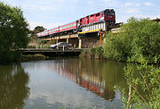
McIntyre Bridge
The 192 metre long McIntyre Bridge is located to the east of the James Harrison Bridge, and has a concrete walkway and pipe supported with steel cable staysCable-stayed bridge
A cable-stayed bridge is a bridge that consists of one or more columns , with cables supporting the bridge deck....
. Constructed in 1967 to carry sewage from Geelong to the ocean outfall at Black Rock
Breamlea, Victoria
Breamlea, Victoria, Australia, is a secluded seaside hamlet located 28 km south of Geelong on the south coast of Australia halfway between Barwon Heads and Torquay on the Bellarine Peninsula. At the 2006 census, Breamlea and the surrounding area had a population of 244.-Geography:Breamlea is...
, the bridge provided relief for the 1916 sewer aqueduct further downstream. The bridge designed by J.L. van der Molen, and was one of the first in Australia to use computer engineering in the design process.
James Harrison Bridge
Princes Highway
The Princes Highway extends from Sydney to Port Augusta via the coast through the states of New South Wales, Victoria and South Australia, a distance of 1941 km or 1898 km via the former alignments of the highway ....
though Geelong. Construction started in 1988 and was completed in 1990, removing heavy through traffic from the main Belmont shopping centre. Consisting of twin parallel two lane bridges, The main river span is of concrete cantilever
Cantilever bridge
A cantilever bridge is a bridge built using cantilevers, structures that project horizontally into space, supported on only one end. For small footbridges, the cantilevers may be simple beams; however, large cantilever bridges designed to handle road or rail traffic use trusses built from...
design, with a number of smaller concrete box girder spans completing the viaduct to the south. The bridge was named after Geelong engineer and refrigeration pioneer James Harrison
James Harrison (engineer)
James Harrison was an Australian newspaper printer, journalist, politician, and pioneer in the field of mechanical refrigeration.-Early life:...
.
Barwon Bridge
The four lane Barwon Bridge carries Moorabool Street over the river, and is located on the site of the first Barwon crossing.The first wooden bridge opened early in 1848. Tolled by the South Barwon council, 4 years later it was swept away in a massive flood on 23 May 1852. From December that year a government punt
Punt (boat)
A punt is a flat-bottomed boat with a square-cut bow, designed for use in small rivers or other shallow water. Punting refers to boating in a punt. The punter generally propels the punt by pushing against the river bed with a pole...
operated at the site. By late 1853 two government punts were used to form a pontoon bridge
Pontoon bridge
A pontoon bridge or floating bridge is a bridge that floats on water and in which barge- or boat-like pontoons support the bridge deck and its dynamic loads. While pontoon bridges are usually temporary structures, some are used for long periods of time...
. It was not until 1859 that a proper iron bridge was opened as a replacement. The bridge was narrow, and was only two lanes wide. The old iron bridge was too narrow to permit the extension of tram
Tram
A tram is a passenger rail vehicle which runs on tracks along public urban streets and also sometimes on separate rights of way. It may also run between cities and/or towns , and/or partially grade separated even in the cities...
s into Belmont, so was dismantled 1924.
The new bridge was designed by Country Roads Board
Country Roads Board
The Country Roads Board was the government authority responsible for the construction and maintenance of main roads in the State of Victoria, Australia between 1913 and 1983. Its first chairman was William Calder who remained in charge until his death in 1928...
engineer D V Darwin
Donald Victor Darwin
Donald Victor Darwin, , M.M., M.C.E., M.I.C.E., M.I.E. , CE., F.A.P.I., civil engineer, was born on 11 October 1896 at Redhill, South Australia, son of Henry Darwin, a native-born bank manager, and his wife Jessie Louise Cleta, née Gmeiner...
and opened on 18 August 1926 by Governor of Victoria
Governors of Victoria
The Governor of Victoria is the representative in the Australian state of Victoria of its monarch, Elizabeth II, Queen of Australia. The Governor performs the same constitutional and ceremonial functions at the state level as does the Governor-General of Australia at the national level...
Lord Sommers
Arthur Somers-Cocks, 6th Baron Somers
Lieutenant-Colonel Arthur Herbert Tennyson Somers-Cocks, 6th Baron Somers, KCMG, DSO, MC , son of Herbert Haldane Somers-Cocks by Blanche Margaret Standish Clogstoun...
. Of concrete and steel girder construction, it was built by Armstrong Whitworth Pty Ltd, it cost 73900 pounds
Australian pound
The pound was the currency of Australia from 1910 until 13 February 1966, when it was replaced by the Australian dollar. It was subdivided into 20 shillings, each of 12 pence.- Earlier Australian currencies :...
($147800) to build. The 1926 bridge was widened to four lanes in 1966 with the addition to each side of the deck.
Breakwater Bridge
Ford (crossing)
A ford is a shallow place with good footing where a river or stream may be crossed by wading or in a vehicle. A ford is mostly a natural phenomenon, in contrast to a low water crossing, which is an artificial bridge that allows crossing a river or stream when water is low.The names of many towns...
running on top of the breakwater.
A timber trestle railway bridge was built over the top in 1876 when the Geelong railway line
Geelong railway line, Victoria
The Geelong Line is a regional passenger rail service operated by V/Line in Victoria, Australia. It serves passengers between state capital Melbourne and the regional city of Geelong....
was extended to Winchelsea
Winchelsea, Victoria
Winchelsea is a town in Victoria, Australia. It is in the Surf Coast Shire local government area and located on the Barwon River 115 km south-west of Melbourne and close to Geelong .- History :...
. This bridge was replaced by a concrete and steel girder bridge in the 1960s, but the remains of the wooden supports are still visible today.
The current road bridge was built by the Country Roads Board
Country Roads Board
The Country Roads Board was the government authority responsible for the construction and maintenance of main roads in the State of Victoria, Australia between 1913 and 1983. Its first chairman was William Calder who remained in charge until his death in 1928...
in the mid 1960s. This bridge has a low 3.7 metre clearance underneath the railway viaduct and is close to the water, resulting in a number of stuck trucks and frequent closure due to river flooding. In 2009 VicRoads
VicRoads
VicRoads or the Roads Corporation of Victoria is a statutory corporation which is the state road and traffic authority in the state of Victoria, Australia. It is responsible for maintenance and construction of the state arterial road network, as well as driver licensing and vehicle registration. ...
received planning permission to replace the existing road crossing with a new high level bridge further upstream to eliminate these issues, at a cost of $63 million with completion due in mid 2012.
Sewer Aqueduct
A sewage aqueduct was constructed between 1913 and 1916 to carry sewage from Geelong to an ocean outfall at Black RockBreamlea, Victoria
Breamlea, Victoria, Australia, is a secluded seaside hamlet located 28 km south of Geelong on the south coast of Australia halfway between Barwon Heads and Torquay on the Bellarine Peninsula. At the 2006 census, Breamlea and the surrounding area had a population of 244.-Geography:Breamlea is...
. Of reinforced concrete construction, is a structure of extraordinary design and listed on the Victorian National Estate Register. The designer was an engineer Edward Giles Stone
Edward Giles Stone
Edward Giles Stone was an Australian engineer prominent in many innovative, often daringly and spectacular, aspects of early reinforced concrete constructions in Australia. He was also involved in cement manufacture....
who erected many daring structures in reinforced concrete. It has 14 cantilever
Cantilever bridge
A cantilever bridge is a bridge built using cantilevers, structures that project horizontally into space, supported on only one end. For small footbridges, the cantilevers may be simple beams; however, large cantilever bridges designed to handle road or rail traffic use trusses built from...
spans covering more than 760 metres. The viaduct was decommissioned in 1993, with the land and river underneath fenced off from public access due to falling debris, the deterioration due to the loss of calcium from its concrete. The replacement for the sewer was a pump-boosted gravity system.
Barwon Heads Bridge
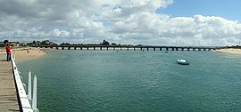
Barwon Heads, Victoria
Barwon Heads is a coastal township on the Bellarine Peninsula, near Geelong, Victoria, Australia. It is situated on the west bank of the mouth of the Barwon River below Lake Connewarre, while it is bounded to the west by farmland, golf courses and the ephemeral saline wetland Murtnaghurt...
and Ocean Grove
Ocean Grove, Victoria
Ocean Grove is a seaside town in Victoria, Australia, located on the Bellarine Peninsula. At the 2006 census, Ocean Grove had a population of 11,274.-History:...
was built in 1927. Before this time a ferry ran by Tom Abernathy operated across the mount of the Barwon. The bridge was used in filming the ABC television series SeaChange
SeaChange
SeaChange was a popular Australian television show that ran for 39 episodes from 1998 to 2001 on the ABC. It was created by Andrew Knight and Deborah Cox and starred Sigrid Thornton, David Wenham, William McInnes, John Howard, Tom Long and Kerry Armstrong...
.
In July 2006, the Government of Victoria
Government of Victoria
The Government of Victoria, under the Constitution of Australia, ceded certain legislative and judicial powers to the Commonwealth, but retained complete independence in all other areas...
shelved plans to replace the heritage-listed bridge with a new one, with plans put forward for an upgraded to be carried out instead. The new Barwon Heads Bridge
Barwon Heads Bridge
The Barwon Heads Bridge is a road bridge and a separate pedestrian bridge over the Barwon River between Barwon Heads and Ocean Grove, Victoria , Australia. The bridge is the only crossing of the Barwon River between Geelong and the river mouth at...
was constructed in 2010.