
Bedford, Massachusetts
Encyclopedia
Bedford is a town in Middlesex County
, Massachusetts
, United States
. It is within the Greater Boston
area, 15 miles (24.1 km) north-west of the city of Boston. The population of Bedford was 13,320 at the 2010 census.
The land now within the boundaries of Bedford was first settled by Europeans around 1640. In 1729 it was incorporated from a portion of Concord (about 3/5 of Bedford) and a portion of Billerica
(about 2/5 of Bedford.)
In 1630 came the arrival of John Winthrop
and Thomas Dudley
of the Massachusetts Bay Company. Aboard the Arabella from Yarmouth, England
, Winthrop and Dudley sailed, and after a difficult ten week voyage, they landed on the shores of the New World
, with Salem
and Boston Harbor
being the Arabella's earliest destinations. In 1637, the General Court of Massachusetts granted some 2,200 acres (9 km²) of land, including Huckins Farm land to the first Governor, John Winthrop, and to Deputy Governor Thomas Dudley. The following year, the two men agreed to divide the land so that the parcel south of the two large boulders by the Concord River
(Brothers Rocks) belonged to Governor Winthrop and north of the Rocks was to belong to Deputy Governor Dudley. Later, Dudley became governor. Dudley’s son Rev. Samuel Dudley and Winthrop’s daughter Mary were married, thus Brothers Rocks were so named because of this marriage of families.
About the Huckins Farm and Job Lane House properties
Governor Winthrop’s grandson, Fitz John Winthrop, in 1664, sold 1,200 acres (5 km²) of this land (including what is present day Huckins Farm) to Job Lane (1), a skilled artisan and house builder, in exchange for a house that Lane built for him in Connecticut. (Note: The numbers appended to the names of Lane family members indicate the generation number beginning with Job Lane (1), who immigrated from Rickmansworth, England.) Upon his death, he passed all of this land to his son, John Lane (2), who left it to his three sons, John Lane (3), Job Lane (3), and James Lane (3). John Lane and his wife, Catherine (Whiting), lived on the site, and after she died, he married Hannah Abbott. Upon his death in 1763, their son, Samuel Lane, inherited the land we know as Huckins Farm. Some time after Samuel Lane died in 1802, the house was removed and Peter Farmer built the present farmhouse in the 1840s. We know that Peter and Dorcas Farmer had two children in the late 1820s and 1830s. Later, Banfield succeeded Farmer as the owner.
Samuel W. Huckins, born in 1817, settled on the land about 1870. Huckins was respected for his good judgment and was honored with various offices in town. Maps circa 1875 indicate that what we know as Dudley Road was called Huckins Street. Samuel Huckins lived there until his death in 1892. He had a son, Henry, who was born in 1849, and was living in Bedford in 1910.
In the late 19th century, Dudley Leavitt Pickman, descendant of an old Salem merchant family
, and his wife Ellen fell in love with the land. They bought a substantial parcel (mostly Winthrop’s land and a portion of Dudley’s grant). Huckins Farm was a part of this purchase. A direct descendant of both Winthrop and Dudley, Pickman bought the land without knowledge of the Winthrop-Dudley grant. He discovered later that he had purchased his ancestors' lands. The land was used as a dairy farm and apple orchard, in addition to the fields, pasture land, bog garden, and ponds. Chestnut trees lined the old road between the fields. A portion of Dudley Road was named Chestnut Avenue around that time. (Today's Dudley Road and Winthrop
Avenue in Bedford, as well as Pickman Drive, are named for these families.)
A large portion of the Pickman land, Huckins Farm, was sold to a developer for condominium development in 1987, and other parcels including the large Pickman house (Stearns Farm) were sold to private parties.
_bedford,_massachusetts.jpg)
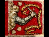
 The Bedford Flag
The Bedford Flag
"By the rude bridge that arched the flood, their flag to April's breeze unfurled - here once the embattled farmers stood, and fired the shot heard 'round the world." ~ Ralph Waldo Emerson
The Bedford flag
on display at the Bedford Free Public Library
is the oldest known surviving intact battle flag in the United States. It is celebrated for having been the first U.S. flag flown during the American Revolutionary War
, as it is believed to have been carried by Nathaniel Page's outfit of Minutemen
to the Old North Bridge
in Concord
for the Battle of Concord on April 19, 1775.
Though the flag previously had a border of silver tassels, the tassels were cut from the flag to adorn the dress of Page's daughter.
The Latin motto on the flag, "Vince Aut Morire", means "Conquer or Die."
The Two Brothers Rocks
When Governor Winthrop and his Deputy Thomas Dudley viewed their lands in early 1638, they decided to use two great stones on the eastern bank of the Concord River to divide the property. Winthrop claimed the land to one side of one rock; Dudley claimed the land on the other side of the other rock. They named the rocks "The Two Brothers." Over the years, the two men had many differences; however they learned to work together and even considered themselves "brothers" by their children's marriage. The rocks have come to symbolize the men's spirit of cooperation and democracy. The Two Brothers Rocks can still be seen near the banks of the Concord River in the Great Meadows National Wildlife Refuge. This site has recently been restored for an Eagle Scout project by Dennis Warner in collaboration with the U.S. Fish and Wildlife service, and the Bedford Historic Preservation Commission.
Great Meadows National Wildlife Refuge
The early settlers called this area along the Concord River, "Great River Meadow" because they could harvest hay along the grass banks when the water retreated each summer. Today, this 12 miles (19.3 km) stretch of freshwater wetlands is a sanctuary for migratory birds and wildlife. There are deer, cottontail rabbit, fox, raccoon, muskrat, beaver, weasel and over 200 species of birds seen here.
Job Lane House
This traditional saltbox-style home at 295 North Road dates back to the early 18th century and was built by Job Lane (3), the grandson of one of Bedford's earliest settlers, Job Lane (1), a master carpenter. Job Lane (3) was a church deacon and also a town officer. His son Job Lane (4) was a Minuteman; he was wounded in the battle of Concord. The house and grounds, not far from Huckins Farm, has been restored and is open to the public from 2-4 PM on the second and fourth Sunday of the month, May through October.
Fitch Tavern
Early on the morning of April 19, 1775, an alarm sounded warning the people of Bedford that British soldiers were marching from Boston to Concord. Their captain, Jonathan Willson, told them, "It is a cold breakfast boys, but we'll give them a hot dinner." The Fitch Tavern is located in Bedford center, a little over a mile from Huckins Farm.
John Wilson Corne Mill
The ruins of this old mill over Vine Brook (on Wilson and Old Burlington Road) was added to the national historical register in 2003 (see photo
). A 1972 "Bedford Landmark Tour" says, "Site of the Wilson mills dating from about 1685; mills, dam, and pond passed from the Wilson family about 1770 to Oliver Bacon, then bought by Jonas Gleason (1782) and by Simeon Blodgett (1816); through the years, the site was operated as a grist mill, a saw mill, and later a cider mill."
, the town has a total area of 13.9 square miles (36 km²), of which, 13.7 square miles (35.5 km²) of it is land and 0.1 square mile (0.258998811 km²) of it (0.94%) is water. Bedford is approximately 15 miles (24 km) away from the coast.
Bedford is a relatively circular town. Its neighbors, clockwise, starting from 12 o'clock, are: Billerica
, Burlington
, Lexington
, Lincoln
, Concord
, and Carlisle
.
In addition to the Concord River
which forms part of the town's borders, the Shawsheen River
flows through town. Vine Brook
flows from Lexington, Massachusetts
, through Burlington, Massachusetts
, and into the Shawsheen in Bedford. In the 1840s, a large paper mill was built on Vine Brook, that supplied many of the jobs in town.
of 2000, there were 12,595 people, 4,621 households, and 3,419 families residing in the town. The population density
was 916.7 people per square mile (353.9/km²). There were 4,708 housing units at an average density of 342.7 per square mile (132.3/km²). The racial makeup of the town was 91.19% White, 1.65% African American, 0.22% Native American, 5.40% Asian, 0.34% from other races
, and 1.19% from two or more races. Hispanic or Latino of any race were 1.80% of the population.
There were 4,621 households out of which 34.1% had children under the age of 18 living with them, 64.4% were married couples
living together, 7.3% had a female householder with no husband present, and 26.0% were non-families. 21.8% of all households were made up of individuals and 10.2% had someone living alone who was 65 years of age or older. The average household size was 2.60 and the average family size was 3.04.
In the town the population was spread out with 23.6% under the age of 18, 3.9% from 18 to 24, 27.8% from 25 to 44, 26.3% from 45 to 64, and 18.3% who were 65 years of age or older. The median age was 42 years. For every 100 females there were 99.3 males. For every 100 females age 18 and over, there were 96.3 males.
The median income for a household was $87,962, and the median income for a family was $101,081. Males had a median income of $65,697 versus $45,181 for females. The per capita income
for the town was $39,212. About 1.4% of families and 2.5% of the population were below the poverty line, including 3.1% of those under age 18 and 4.0% of those age 65 or over.
as its legislature
. The executive branch consists of a Board of Selectmen
who oversee a town Administrator.
Bedford was the home of a Consolidated Mail Outpatient Pharmacy (CMOP). It was the part of an initiative by the Department of Veterans Affairs to provide mail order prescriptions to veterans using computerization at strategic locations throughout the United States. It has moved to the Lowell area as a result of the Veterans Administrations Cares Mission and is no longer in Bedford, Mass.
(9–12). Some students from Hanscom Air Force Base
, which is partially located in Bedford, join Bedford residents at Bedford High for 9th grade and beyond. There is a METCO
program, where students from Boston come to the Bedford schools, starting in kindergarten and stay with the class until graduation. Bedford is also part of the school district of Shawsheen Valley Technical High School
which is in nearby Billerica
.
Bedford schools are commonly ranked among the top ten in state.
The former Center School was deactivated in the 1970s. Center School is today the Town Center and Recreation Department. Nathaniel Page School was similarly deactivated in about 1982 and today is a condominium community. Davis, Lane, and Page elementary schools were all (k–5) at one time. John Glenn Middle School (originally called Bedford Junior High School) is named for John Glenn, formerly the Superintendent of Schools in Bedford, not for the U.S. Senator and astronaut. The Davis and Lane (and former Page) schools are named for local officers who took part in the Battle of Concord on April 19, 1775.
 Bedford is located slightly northwest of the intersection of I-95
(also known as MA-128
) and MA-4
/MA-225
(which actually cross in Lexington
). Important roadways through town include US-3
(an expressway) and MA-62
. It is serviced by the 62 and 62/76 lines of the MBTA
's bus
service. Bedford is also served by Hanscom Field
, a civilian airport
, which is located adjacent to Hanscom Air Force Base
.
A snowstorm on January 10, 1977, prompted the end of passenger service on the Lexington Branch of the Boston & Maine Railroad (see additional notes under Boston and Lowell Railroad
). The line was embargoed four years later. In 1991, the branch was railbanked by the Interstate Commerce Commission. It is now used for the Minuteman Bikeway. In the early 20th century, the Middlesex & Boston Street Railway line ran generally down Great Road (Routes 4 and 225), with lines from as far west as Hudson
running into Lexington and beyond.
Other historic transportation systems through Bedford included the narrow-gauge Billerica and Bedford Railroad and the Middlesex Turnpike
.
Middlesex County, Massachusetts
-National protected areas:* Assabet River National Wildlife Refuge* Great Meadows National Wildlife Refuge* Longfellow National Historic Site* Lowell National Historical Park* Minute Man National Historical Park* Oxbow National Wildlife Refuge...
, Massachusetts
Massachusetts
The Commonwealth of Massachusetts is a state in the New England region of the northeastern United States of America. It is bordered by Rhode Island and Connecticut to the south, New York to the west, and Vermont and New Hampshire to the north; at its east lies the Atlantic Ocean. As of the 2010...
, United States
United States
The United States of America is a federal constitutional republic comprising fifty states and a federal district...
. It is within the Greater Boston
Greater Boston
Greater Boston is the area of the Commonwealth of Massachusetts surrounding the city of Boston. Due to ambiguity in usage, the size of the area referred to can be anywhere between that of the metropolitan statistical area of Boston and that of the city's combined statistical area which includes...
area, 15 miles (24.1 km) north-west of the city of Boston. The population of Bedford was 13,320 at the 2010 census.
History
The following compilation comes from Ellen Abrams (1999) based on information from Abram English Brown’s History of the Town of Bedford (1891), as well as other sources such as The Bedford Sampler Bicentennial Edition containing Daisy Pickman Oakley’s articles, Bedford Vital Records, New England Historical and Genealogical Register, Town Directories, and other publications from the Bedford Historical Society.The land now within the boundaries of Bedford was first settled by Europeans around 1640. In 1729 it was incorporated from a portion of Concord (about 3/5 of Bedford) and a portion of Billerica
Billerica, Massachusetts
Billerica is a town in Middlesex County, Massachusetts, United States. The population was 40,243 at the 2010 census. It is the only town named Billerica in the United States and borrows its name from the town of Billericay in Essex, England.- History :...
(about 2/5 of Bedford.)
In 1630 came the arrival of John Winthrop
John Winthrop
John Winthrop was a wealthy English Puritan lawyer, and one of the leading figures in the founding of the Massachusetts Bay Colony, the first major settlement in New England after Plymouth Colony. Winthrop led the first large wave of migrants from England in 1630, and served as governor for 12 of...
and Thomas Dudley
Thomas Dudley
Thomas Dudley was a colonial magistrate who served several terms as governor of the Massachusetts Bay Colony. Dudley was the chief founder of Newtowne, later Cambridge, Massachusetts, and built the town's first home...
of the Massachusetts Bay Company. Aboard the Arabella from Yarmouth, England
Yarmouth, Isle of Wight
Yarmouth is a port and civil parish in the western part of the Isle of Wight, off the southern coast of mainland England. The town is named for its location at the mouth of the small Western Yar river...
, Winthrop and Dudley sailed, and after a difficult ten week voyage, they landed on the shores of the New World
New World
The New World is one of the names used for the Western Hemisphere, specifically America and sometimes Oceania . The term originated in the late 15th century, when America had been recently discovered by European explorers, expanding the geographical horizon of the people of the European middle...
, with Salem
Salem, Massachusetts
Salem is a city in Essex County, Massachusetts, United States. The population was 40,407 at the 2000 census. It and Lawrence are the county seats of Essex County...
and Boston Harbor
Port of Boston
The Port of Boston, , is a major seaport located in Boston Harbor and adjacent to the City of Boston...
being the Arabella's earliest destinations. In 1637, the General Court of Massachusetts granted some 2,200 acres (9 km²) of land, including Huckins Farm land to the first Governor, John Winthrop, and to Deputy Governor Thomas Dudley. The following year, the two men agreed to divide the land so that the parcel south of the two large boulders by the Concord River
Concord River
The Concord River is a tributary of the Merrimack River in eastern Massachusetts in the United States. The river drains a small rural and suburban region northwest of Boston. One of the most famous small rivers in U.S...
(Brothers Rocks) belonged to Governor Winthrop and north of the Rocks was to belong to Deputy Governor Dudley. Later, Dudley became governor. Dudley’s son Rev. Samuel Dudley and Winthrop’s daughter Mary were married, thus Brothers Rocks were so named because of this marriage of families.
About the Huckins Farm and Job Lane House properties
Governor Winthrop’s grandson, Fitz John Winthrop, in 1664, sold 1,200 acres (5 km²) of this land (including what is present day Huckins Farm) to Job Lane (1), a skilled artisan and house builder, in exchange for a house that Lane built for him in Connecticut. (Note: The numbers appended to the names of Lane family members indicate the generation number beginning with Job Lane (1), who immigrated from Rickmansworth, England.) Upon his death, he passed all of this land to his son, John Lane (2), who left it to his three sons, John Lane (3), Job Lane (3), and James Lane (3). John Lane and his wife, Catherine (Whiting), lived on the site, and after she died, he married Hannah Abbott. Upon his death in 1763, their son, Samuel Lane, inherited the land we know as Huckins Farm. Some time after Samuel Lane died in 1802, the house was removed and Peter Farmer built the present farmhouse in the 1840s. We know that Peter and Dorcas Farmer had two children in the late 1820s and 1830s. Later, Banfield succeeded Farmer as the owner.
Samuel W. Huckins, born in 1817, settled on the land about 1870. Huckins was respected for his good judgment and was honored with various offices in town. Maps circa 1875 indicate that what we know as Dudley Road was called Huckins Street. Samuel Huckins lived there until his death in 1892. He had a son, Henry, who was born in 1849, and was living in Bedford in 1910.
In the late 19th century, Dudley Leavitt Pickman, descendant of an old Salem merchant family
Dudley Leavitt Pickman
Dudley Leavitt Pickman was a Salem, Massachusetts, merchant who built one of the great Salem trading firms during the seaport's ascendancy as a trading power in the late eighteenth and early nineteenth centuries. Pickman was a partner in the firm Devereux, Pickman & Silsbee and a state senator...
, and his wife Ellen fell in love with the land. They bought a substantial parcel (mostly Winthrop’s land and a portion of Dudley’s grant). Huckins Farm was a part of this purchase. A direct descendant of both Winthrop and Dudley, Pickman bought the land without knowledge of the Winthrop-Dudley grant. He discovered later that he had purchased his ancestors' lands. The land was used as a dairy farm and apple orchard, in addition to the fields, pasture land, bog garden, and ponds. Chestnut trees lined the old road between the fields. A portion of Dudley Road was named Chestnut Avenue around that time. (Today's Dudley Road and Winthrop
Avenue in Bedford, as well as Pickman Drive, are named for these families.)
A large portion of the Pickman land, Huckins Farm, was sold to a developer for condominium development in 1987, and other parcels including the large Pickman house (Stearns Farm) were sold to private parties.
Historical Sites
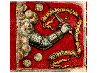
"By the rude bridge that arched the flood, their flag to April's breeze unfurled - here once the embattled farmers stood, and fired the shot heard 'round the world." ~ Ralph Waldo Emerson
Ralph Waldo Emerson
Ralph Waldo Emerson was an American essayist, lecturer, and poet, who led the Transcendentalist movement of the mid-19th century...
The Bedford flag
Bedford Flag
The Bedford Flag is the oldest known flag in the United States. It was supposedly borne by the Bedford Minuteman Company and might have flown at the North Bridge in Concord, Massachusetts, on April 19, 1775. Its history is controversial...
on display at the Bedford Free Public Library
Bedford Free Public Library
The Bedford Free Public Library is a public library in Bedford, Massachusetts.-External links:* http://www.bedfordlibrary.net/* . Posts about the library...
is the oldest known surviving intact battle flag in the United States. It is celebrated for having been the first U.S. flag flown during the American Revolutionary War
American Revolutionary War
The American Revolutionary War , the American War of Independence, or simply the Revolutionary War, began as a war between the Kingdom of Great Britain and thirteen British colonies in North America, and ended in a global war between several European great powers.The war was the result of the...
, as it is believed to have been carried by Nathaniel Page's outfit of Minutemen
Minutemen
Minutemen were members of teams of select men from the American colonial partisan militia during the American Revolutionary War. They provided a highly mobile, rapidly deployed force that allowed the colonies to respond immediately to war threats, hence the name.The minutemen were among the first...
to the Old North Bridge
Old North Bridge, Concord, Massachusetts
The North Bridge, often colloquially called the Old North Bridge, across the Concord River in Concord, Massachusetts, is a historical site in the Battle of Concord, the first day of battle in the Revolutionary War....
in Concord
Concord, Massachusetts
Concord is a town in Middlesex County, Massachusetts, in the United States. As of the 2010 census, the town population was 17,668. Although a small town, Concord is noted for its leading roles in American history and literature.-History:...
for the Battle of Concord on April 19, 1775.
Though the flag previously had a border of silver tassels, the tassels were cut from the flag to adorn the dress of Page's daughter.
The Latin motto on the flag, "Vince Aut Morire", means "Conquer or Die."
The Two Brothers Rocks
When Governor Winthrop and his Deputy Thomas Dudley viewed their lands in early 1638, they decided to use two great stones on the eastern bank of the Concord River to divide the property. Winthrop claimed the land to one side of one rock; Dudley claimed the land on the other side of the other rock. They named the rocks "The Two Brothers." Over the years, the two men had many differences; however they learned to work together and even considered themselves "brothers" by their children's marriage. The rocks have come to symbolize the men's spirit of cooperation and democracy. The Two Brothers Rocks can still be seen near the banks of the Concord River in the Great Meadows National Wildlife Refuge. This site has recently been restored for an Eagle Scout project by Dennis Warner in collaboration with the U.S. Fish and Wildlife service, and the Bedford Historic Preservation Commission.
Great Meadows National Wildlife Refuge
The early settlers called this area along the Concord River, "Great River Meadow" because they could harvest hay along the grass banks when the water retreated each summer. Today, this 12 miles (19.3 km) stretch of freshwater wetlands is a sanctuary for migratory birds and wildlife. There are deer, cottontail rabbit, fox, raccoon, muskrat, beaver, weasel and over 200 species of birds seen here.
Job Lane House
This traditional saltbox-style home at 295 North Road dates back to the early 18th century and was built by Job Lane (3), the grandson of one of Bedford's earliest settlers, Job Lane (1), a master carpenter. Job Lane (3) was a church deacon and also a town officer. His son Job Lane (4) was a Minuteman; he was wounded in the battle of Concord. The house and grounds, not far from Huckins Farm, has been restored and is open to the public from 2-4 PM on the second and fourth Sunday of the month, May through October.
Fitch Tavern
Early on the morning of April 19, 1775, an alarm sounded warning the people of Bedford that British soldiers were marching from Boston to Concord. Their captain, Jonathan Willson, told them, "It is a cold breakfast boys, but we'll give them a hot dinner." The Fitch Tavern is located in Bedford center, a little over a mile from Huckins Farm.
John Wilson Corne Mill
The ruins of this old mill over Vine Brook (on Wilson and Old Burlington Road) was added to the national historical register in 2003 (see photo
Wilson Mill-Old Burlington Road District
Wilson Mill—Old Burlington Road District is a historic district on Old Burlington Road and Wilson Road in Bedford, Massachusetts.It was added to the National Register of Historic Places in 2003....
). A 1972 "Bedford Landmark Tour" says, "Site of the Wilson mills dating from about 1685; mills, dam, and pond passed from the Wilson family about 1770 to Oliver Bacon, then bought by Jonas Gleason (1782) and by Simeon Blodgett (1816); through the years, the site was operated as a grist mill, a saw mill, and later a cider mill."
Geography
According to the United States Census BureauUnited States Census Bureau
The United States Census Bureau is the government agency that is responsible for the United States Census. It also gathers other national demographic and economic data...
, the town has a total area of 13.9 square miles (36 km²), of which, 13.7 square miles (35.5 km²) of it is land and 0.1 square mile (0.258998811 km²) of it (0.94%) is water. Bedford is approximately 15 miles (24 km) away from the coast.
Bedford is a relatively circular town. Its neighbors, clockwise, starting from 12 o'clock, are: Billerica
Billerica, Massachusetts
Billerica is a town in Middlesex County, Massachusetts, United States. The population was 40,243 at the 2010 census. It is the only town named Billerica in the United States and borrows its name from the town of Billericay in Essex, England.- History :...
, Burlington
Burlington, Massachusetts
Burlington is a town in Middlesex County, Massachusetts, United States. The population was 24,498 at the 2010 census.- History :It is believed that Burlington takes its name from the English town of Bridlington, however this has never been confirmed....
, Lexington
Lexington, Massachusetts
Lexington is a town in Middlesex County, Massachusetts, United States. The population was 31,399 at the 2010 census. This town is famous for being the site of the first shot of the American Revolution, in the Battle of Lexington on April 19, 1775.- History :...
, Lincoln
Lincoln, Massachusetts
Lincoln is a town in the historic area of Middlesex County, Massachusetts, United States. The population was 6,362 at the 2010 census, including residents of Hanscom Air Force Base that live within town limits...
, Concord
Concord, Massachusetts
Concord is a town in Middlesex County, Massachusetts, in the United States. As of the 2010 census, the town population was 17,668. Although a small town, Concord is noted for its leading roles in American history and literature.-History:...
, and Carlisle
Carlisle, Massachusetts
Carlisle is an affluent, rural town northwest of Boston located in Middlesex County, Massachusetts, United States. According to the 2010 U.S. Census, the population of the town is 4,852.-History:...
.
In addition to the Concord River
Concord River
The Concord River is a tributary of the Merrimack River in eastern Massachusetts in the United States. The river drains a small rural and suburban region northwest of Boston. One of the most famous small rivers in U.S...
which forms part of the town's borders, the Shawsheen River
Shawsheen River
The Shawsheen River is a tributary of the Merrimack River in northeast Massachusetts. The name has had various spellings. According to Bailey's history of Andover, the spelling Shawshin was the most common in the old records, although Shawshine, Shashin, Shashine, Shashene, Shawshene, and later,...
flows through town. Vine Brook
Vine Brook
Vine Brook is a brook in Middlesex County, USA. According to the History of Bedford, Vine Brook is "an important tributary of Shawsheen River." The book also states it as an excellent source of water-power in the 17th to 19th Centuries....
flows from Lexington, Massachusetts
Lexington, Massachusetts
Lexington is a town in Middlesex County, Massachusetts, United States. The population was 31,399 at the 2010 census. This town is famous for being the site of the first shot of the American Revolution, in the Battle of Lexington on April 19, 1775.- History :...
, through Burlington, Massachusetts
Burlington, Massachusetts
Burlington is a town in Middlesex County, Massachusetts, United States. The population was 24,498 at the 2010 census.- History :It is believed that Burlington takes its name from the English town of Bridlington, however this has never been confirmed....
, and into the Shawsheen in Bedford. In the 1840s, a large paper mill was built on Vine Brook, that supplied many of the jobs in town.
Demographics
As of the censusCensus
A census is the procedure of systematically acquiring and recording information about the members of a given population. It is a regularly occurring and official count of a particular population. The term is used mostly in connection with national population and housing censuses; other common...
of 2000, there were 12,595 people, 4,621 households, and 3,419 families residing in the town. The population density
Population density
Population density is a measurement of population per unit area or unit volume. It is frequently applied to living organisms, and particularly to humans...
was 916.7 people per square mile (353.9/km²). There were 4,708 housing units at an average density of 342.7 per square mile (132.3/km²). The racial makeup of the town was 91.19% White, 1.65% African American, 0.22% Native American, 5.40% Asian, 0.34% from other races
Race (United States Census)
Race and ethnicity in the United States Census, as defined by the Federal Office of Management and Budget and the United States Census Bureau, are self-identification data items in which residents choose the race or races with which they most closely identify, and indicate whether or not they are...
, and 1.19% from two or more races. Hispanic or Latino of any race were 1.80% of the population.
There were 4,621 households out of which 34.1% had children under the age of 18 living with them, 64.4% were married couples
Marriage
Marriage is a social union or legal contract between people that creates kinship. It is an institution in which interpersonal relationships, usually intimate and sexual, are acknowledged in a variety of ways, depending on the culture or subculture in which it is found...
living together, 7.3% had a female householder with no husband present, and 26.0% were non-families. 21.8% of all households were made up of individuals and 10.2% had someone living alone who was 65 years of age or older. The average household size was 2.60 and the average family size was 3.04.
In the town the population was spread out with 23.6% under the age of 18, 3.9% from 18 to 24, 27.8% from 25 to 44, 26.3% from 45 to 64, and 18.3% who were 65 years of age or older. The median age was 42 years. For every 100 females there were 99.3 males. For every 100 females age 18 and over, there were 96.3 males.
The median income for a household was $87,962, and the median income for a family was $101,081. Males had a median income of $65,697 versus $45,181 for females. The per capita income
Per capita income
Per capita income or income per person is a measure of mean income within an economic aggregate, such as a country or city. It is calculated by taking a measure of all sources of income in the aggregate and dividing it by the total population...
for the town was $39,212. About 1.4% of families and 2.5% of the population were below the poverty line, including 3.1% of those under age 18 and 4.0% of those age 65 or over.
Government
The town uses an open town meetingTown meeting
A town meeting is a form of direct democratic rule, used primarily in portions of the United States since the 17th century, in which most or all the members of a community come together to legislate policy and budgets for local government....
as its legislature
Legislature
A legislature is a kind of deliberative assembly with the power to pass, amend, and repeal laws. The law created by a legislature is called legislation or statutory law. In addition to enacting laws, legislatures usually have exclusive authority to raise or lower taxes and adopt the budget and...
. The executive branch consists of a Board of Selectmen
Board of selectmen
The board of selectmen is commonly the executive arm of the government of New England towns in the United States. The board typically consists of three or five members, with or without staggered terms.-History:...
who oversee a town Administrator.
Bedford was the home of a Consolidated Mail Outpatient Pharmacy (CMOP). It was the part of an initiative by the Department of Veterans Affairs to provide mail order prescriptions to veterans using computerization at strategic locations throughout the United States. It has moved to the Lowell area as a result of the Veterans Administrations Cares Mission and is no longer in Bedford, Mass.
Education
Bedford's school system consists of four buildings: Lt. Eleazer Davis Elementary (K–2), Lt. Job Lane Elementary (3–5), John Glenn Middle School (6–8), and Bedford High SchoolBedford High School (Bedford, Massachusetts)
Bedford High School is a public high school in the town of Bedford, Massachusetts. Students come primarily from Bedford. Other students that attend Bedford High School come from the neighboring Hanscom Air Force Base or from Boston through the use of the METCO system...
(9–12). Some students from Hanscom Air Force Base
Hanscom Air Force Base
Hanscom Air Force Base is a United States Air Force base located approximately south-southwest of Bedford, Massachusetts. The facility is a joint use civil airport/military base with Hanscom Field which provides general aviation and charter service.The host unit at Hanscom is the non-flying...
, which is partially located in Bedford, join Bedford residents at Bedford High for 9th grade and beyond. There is a METCO
METCO
METCO stands for the Metropolitan Council for Educational Opportunity. Founded in 1966 in Boston, Massachusetts, METCO is the longest continuously running voluntary school desegregation program in the country and a national model for the few other voluntary desegregation busing programs currently...
program, where students from Boston come to the Bedford schools, starting in kindergarten and stay with the class until graduation. Bedford is also part of the school district of Shawsheen Valley Technical High School
Shawsheen Valley Technical High School
Shawsheen Valley Regional Vocational Technical High School is located in Billerica, Massachusetts. "Shawsheen Tech", or "Shaw Tech" as it is usually called, is a public high school serving 5 towns: Burlington, Wilmington, Bedford, Tewksbury and Billerica making up most of the student...
which is in nearby Billerica
Billerica, Massachusetts
Billerica is a town in Middlesex County, Massachusetts, United States. The population was 40,243 at the 2010 census. It is the only town named Billerica in the United States and borrows its name from the town of Billericay in Essex, England.- History :...
.
Bedford schools are commonly ranked among the top ten in state.
The former Center School was deactivated in the 1970s. Center School is today the Town Center and Recreation Department. Nathaniel Page School was similarly deactivated in about 1982 and today is a condominium community. Davis, Lane, and Page elementary schools were all (k–5) at one time. John Glenn Middle School (originally called Bedford Junior High School) is named for John Glenn, formerly the Superintendent of Schools in Bedford, not for the U.S. Senator and astronaut. The Davis and Lane (and former Page) schools are named for local officers who took part in the Battle of Concord on April 19, 1775.
Famous Bedfordites
- Member of Korean boyband, 2PM2PM2PM is a South Korean boy band, originally a seven-member group, but currently consisting of six members due to the sudden contract termination of leader Jaebeom following an Internet controversy in September 2009. They are managed by JYP Entertainment...
, Ok Taecyeon (옥택연) lived in Bedford, Massachusetts.
- Member of rock band Puddle of MuddPuddle of MuddPuddle Of Mudd is an American rock band from Kansas City, Missouri, USA. To date the band has sold over 7 million albums, and have had a string of #1 mainstream rock singles in the United States. Their major-label debut Come Clean has sold over 5 million copies...
, Doug ArditoDoug ArditoDouglas John Ardito is a bassist, guitarist, and keyboard player from Bedford, Massachusetts.- Biography :Doug Ardito is the bassist/guitarist for Puddle of Mudd which he joined in 1999. That same year, Ardito also recorded two songs with the short-lived supergroup The Wondergirls. Ardito co-wrote...
lived in Bedford, Massachusetts.
- Extreme Skier Doug CoombsDoug CoombsDoug Coombs was an American alpine skier and mountaineer who helped to pioneer the sport of extreme skiing, both in North America and worldwide.- Biography :...
grew up in Bedford, Massachusetts.
Transportation
Interstate 95 in Massachusetts
Interstate 95 is the main highway on the East Coast of the United States, paralleling the Atlantic Ocean from Florida to Maine. The Massachusetts portion of the highway enters from the state of Rhode Island in Attleboro and travels in a northeasterly direction to the junction with Route 128 in...
(also known as MA-128
Route 128 (Massachusetts)
Route 128, also known as the Yankee Division Highway , and originally the Circumferential Highway, is a partial beltway around Boston, Massachusetts, United States. The majority of the highway is built to freeway standards, and about 3/5 of it is part of the Interstate Highway System...
) and MA-4
Route 4 (Massachusetts)
Route 4 is an long state highway in northeastern Massachusetts. It runs south to north, serving many of Boston's western and northwestern suburbs, from an interchange with Route 2 in Lexington northwest to an intersection with Route 3A in North Chelmsford. Much of it, north of Lexington, runs...
/MA-225
Route 225 (Massachusetts)
Route 225 is a northwest-southeast state highway in Massachusetts, which is signed as an east–west route. It was formerly known as Route 25 prior to the construction of Interstate 495 south of Raynham in 1957, which was given the Route 25 designation...
(which actually cross in Lexington
Lexington, Massachusetts
Lexington is a town in Middlesex County, Massachusetts, United States. The population was 31,399 at the 2010 census. This town is famous for being the site of the first shot of the American Revolution, in the Battle of Lexington on April 19, 1775.- History :...
). Important roadways through town include US-3
U.S. Route 3
U.S. Route 3 is a north–south United States highway that runs from its southern terminus in Cambridge, Massachusetts through New Hampshire to its terminus near Third Connecticut Lake at the Canadian border, where the road continues north as Quebec Route 257.In New Hampshire parts of US 3 are...
(an expressway) and MA-62
Route 62 (Massachusetts)
Route 62 is an east–west state highway in Massachusetts. The route crosses four of the Bay State's 13 interstates, as well as U.S. Route 1, U.S...
. It is serviced by the 62 and 62/76 lines of the MBTA
Massachusetts Bay Transportation Authority
The Massachusetts Bay Transportation Authority, often referred to as the MBTA or simply The T, is the public operator of most bus, subway, commuter rail and ferry systems in the greater Boston, Massachusetts, area. Officially a "body politic and corporate, and a political subdivision" of the...
's bus
MBTA Bus
The Massachusetts Bay Transportation Authority operates a large number of bus lines in the greater Boston area. Some routes are for transport within the city; others bring passengers from surrounding areas to stops on the rail lines of the MBTA.The MBTA also operates bus rapid transit service; see...
service. Bedford is also served by Hanscom Field
Hanscom Field
Hanscom Field , also known by its full name Laurence G. Hanscom Field, is a public airport located in Bedford, in Middlesex County, Massachusetts, United States. It is operated by the Massachusetts Port Authority....
, a civilian airport
Airport
An airport is a location where aircraft such as fixed-wing aircraft, helicopters, and blimps take off and land. Aircraft may be stored or maintained at an airport...
, which is located adjacent to Hanscom Air Force Base
Hanscom Air Force Base
Hanscom Air Force Base is a United States Air Force base located approximately south-southwest of Bedford, Massachusetts. The facility is a joint use civil airport/military base with Hanscom Field which provides general aviation and charter service.The host unit at Hanscom is the non-flying...
.
A snowstorm on January 10, 1977, prompted the end of passenger service on the Lexington Branch of the Boston & Maine Railroad (see additional notes under Boston and Lowell Railroad
Boston and Lowell Railroad
The Boston and Lowell Railroad is a historic railroad that operated in Massachusetts. It was one of the first railroads in North America and the first major one in the state...
). The line was embargoed four years later. In 1991, the branch was railbanked by the Interstate Commerce Commission. It is now used for the Minuteman Bikeway. In the early 20th century, the Middlesex & Boston Street Railway line ran generally down Great Road (Routes 4 and 225), with lines from as far west as Hudson
Hudson, Massachusetts
Hudson is a town in Middlesex County, Massachusetts, United States. The population was 19,063 at the 2010 census. The town is located in central Massachusetts, about a 40-minute drive, or about , west of Boston, and about a 20-minute drive, or about , northeast of Worcester.Before its...
running into Lexington and beyond.
Other historic transportation systems through Bedford included the narrow-gauge Billerica and Bedford Railroad and the Middlesex Turnpike
Middlesex Turnpike (Massachusetts)
The Middlesex Turnpike was an early turnpike between Cambridge and Tyngsborough, Massachusetts and the New Hampshire border, where it connected with the Amherst Turnpike and thence Nashua and Claremont, New Hampshire....
.
Further reading
- Boston.com profile of Bedford
- 1871 Atlas of Massachusetts. by Wall & Gray.Map of Massachusetts. Map of Middlesex County.
- History of Middlesex County, Massachusetts, Volume 1 (A-H), Volume 2 (L-W) compiled by Samuel Adams Drake, published 1879 and 1880. 572 and 505 pages. Section on Bedford in Volume 2 page 241 by Josiah A. Stearns.
- History of the Town of Bedford, Middlesex County, Massachusetts, by Abram English Brown, published 1891, 158 pages.
External links
- Town of Bedford official web site
- Bedford Chamber of Commerce
- Bedford Historical Society
- Friends of the Job Lane House
- Bedford Depot Park
- Bedford Fire Department
- Bedford Public Schools
- Bedford Conservation Land Stewards
- Bedford Flag history on the town's site and information on seeing the flag at the Bedford Free Public Library
- Hanscom Air Force Base official web site
- Three Apples Storytelling Festival Annual storytelling festivalStorytelling festivalA storytelling festival is often an annual event that features local, regional and/or nationally known oral storytellers. Each storyteller will have a scheduled amount of time to share a story with an audience...
in the fall