
Massachusetts Bay Transportation Authority
Encyclopedia
The Massachusetts Bay Transportation Authority, often referred to as the MBTA or simply The T, is the public operator of most bus
, subway
, commuter rail and ferry
systems in the greater Boston
, Massachusetts
, area. Officially a "body politic and corporate, and a political subdivision" of the Commonwealth of Massachusetts,
it was formed in 1964. Its immediate predecessor, the Metropolitan Transit Authority (MTA), was immortalized by The Kingston Trio
in the popular folk-protest lament "M.T.A." Locals call it simply "The T", after its logo, the letter T in a circle, adopted in the 1960s and inspired by the Stockholm Metro
. In 2008, the system averaged 1.3 million passenger trips each weekday, of which the subway averaged 598,200, making it the fourth busiest subway system in the United States
.
The Green Line
and Ashmont–Mattapan High Speed Line of the T comprise the busiest light-rail system in the U.S, with a weekday ridership of 255,100.
The MBTA also operates an independent law enforcement agency, the Massachusetts Bay Transportation Authority Police
. In 2006, 31.60% of workers in the city proper
commuted by public transport
.
The MBTA is one of only two U.S. transit agencies that operate all of the five major types of transit vehicles: regional (commuter) rail trains, "heavy" rapid transit (subway/elevated) trains, light rail vehicles (trolleys), electric trolleybuses and motor buses. The other is Philadelphia's Southeastern Pennsylvania Transportation Authority (SEPTA).
The MBTA is the largest consumer of electricity in Massachusetts,
and the second-largest land owner after the Department of Conservation and Recreation
.
As of 2007, its CNG bus fleet was the largest consumer of alternative fuels in the state.
On June 26, 2009, Governor Deval Patrick
signed a law to place the MBTA along with other state transportation agencies within the administrative authority of the Massachusetts Department of Transportation (MassDOT), with the MBTA now part of the Mass Transit division (MassTrans).
The 2009 transportation law continued the MBTA corporate structure and changed the MBTA board membership to the five Governor-appointed members of the Mass DOT Board.
 ]
]
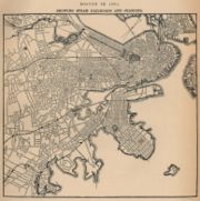
Mass transportation in Boston was provided by private companies, often granted charters by the state legislature for limited monopolies
, with powers of eminent domain
to establish a right-of-way
, until the creation of the MTA in 1947. Development of mass transportation followed both existing economic and population patterns, and helped shape those patterns.
became practical for mass transportation, the private Boston and Lowell Railroad
was chartered in 1830, connecting Boston to Lowell
, a major northerly mill town
, via one of the oldest railroads in North America
. This marked the beginning of the development of American intercity railroads, which in Massachusetts would later become the MBTA Commuter Rail system and the Green Line "D" Branch.
on March 26, 1856, a profusion of streetcar lines appeared in Boston under chartered companies. Therefore, in spite of changes of the companies, Boston is the city with the oldest continuously working streetcar system in the world. Later, many of these companies consolidated, and animal-drawn vehicles were converted to electric propulsion.
s and elevated rail, the former established in 1897 and the latter in 1901, resulting in the Tremont Street Subway
, the first active subway in the United States. These grade-separated railways both added additional transportation capacity and avoided delays caused by intersections with cross streets.
The first elevated railway and the first rapid transit line in Boston came three years before the first underground line of the New York City Subway
, but 34 years after the first London Underground
lines, and long after the first elevated railway in New York.
 Various extensions and branches were built to the subway in both directions, bypassing more surface tracks. As more elevated lines were built, more and more streetcar lines were cut back for faster downtown service.
es in 1922. In 1936, it started replacing some rail vehicles with trackless trolleys. The last Middlesex and Boston Street Railway
streetcar ran in 1930. By the beginning of 1953, the only remaining streetcar lines
fed two tunnels - the main Tremont Street Subway
network downtown and the short tunnel (now the Harvard Bus Tunnel) in Harvard Square
.
was closed in 1938 amidst declining ridership and was demolished in 1942. As rail passenger service became increasingly unprofitable, largely due to rising automobile
ownership, government takeover prevented abandonment and dismantlement of the systems. The MTA purchased and took over subway, elevated, streetcar, and bus operations from the Boston Elevated Railway
in 1947.
In the 1950s, the MTA ran new subway extensions, while the last two streetcar lines running into the Pleasant Street Portal of the Tremont Street Subway
were substituted with buses in 1953 and 1962.
On August 3, 1964, the MBTA succeeded the MTA, with an enlarged service area. The original MTA district of 14 cities and towns was expanded to 78 cities and towns. The MBTA was formed partly to subsidize existing commuter rail operations. As this happened, the MBTA acquired lines in stages from 1973 through 1976 amidst large cutbacks in service and coverage area. Since then, many of these lines have seen service return.
The MBTA assigned colors to its four rapid transit lines in 1965, and lettered the branches of the Green Line from north to south. However, shortages of streetcars, among other factors, caused bus substitution of rail service on two branches of the Green Line. The "A" Branch ceased operating in 1969 as a rail service. The portion of the "E" Branch from Heath Street
to Arborway
was replaced by buses in 1985.
The MBTA purchased bus routes in the outer suburbs to the north and south from the Eastern Massachusetts Street Railway
in 1968. As with the commuter rail system, many of the outlying routes were dropped shortly before or after the takeover due to low ridership and high operating costs.
In the 1970s, the MBTA received a boost from the Boston Transportation Planning Review
areawide re-evaluation of the role of mass transit relative to highways. Producing a moratorium on highway construction inside Route 128, numerous mass transit lines were planned for expansion by the Voorhees-Skidmore, Owings and Merrill-ESL consulting team. The removal of elevated lines continued, and the closure of the Washington Street Elevated
brought the end of rapid transit service to the Roxbury neighborhood. Between 1971 and 1985, the Red Line
was extended both north and south, providing not only additional subway system coverage, but also major parking structures at several of the terminal and intermediate stations.
 A turning point in funding occurred in 2000. Prior to July 1, 2000, the MBTA was reimbursed by the Commonwealth of Massachusetts for all costs above revenue collected (net cost of service). Beginning on that date, the T was granted a dedicated revenue stream consisting of amounts assessed on served cities and towns, along with a dedicated 20% portion of the 5% state sales tax
. The MBTA now must live within this "forward funding" budget.
The Commonwealth assigned to the MBTA responsibility for increasing public transit to compensate for increased automobile pollution from the Big Dig
. The T submerged a nearby portion of the Green Line and rebuilt Haymarket
and North Stations during Big Dig construction. However, these projects have strained the MBTA's limited resources, since the Big Dig project did not include funding for these improvements. Since 1988, the MBTA has been the fastest expanding transit system in the country, even as Greater Boston
has been the slowest growing metropolitan area.
When, in 2000, the MBTA's budget became limited, the agency began to run into debt from scheduled projects and obligatory Big Dig remediation work, which have now given the MBTA the highest debt of any transit authority in the country. In an effort to compensate, rates underwent an appreciable hike on January 1, 2007. Increasingly, local advocacy groups are calling on the state to assume $2.9 billion of the authority's now approximate debt of $9 billion, the interest on which severely limits funds available for required projects.
With the 2004 replacement of the Causeway Street Elevated
with a subway connection, the only remaining elevated railway
s are a short portion of the Red Line
at Charles/MGH
, the stretch of Red Line
between Andrew Station (once the train exits the tunnel beyond Andrew Station going southbound) and proceeding southbound to either Ashmont Station on the Ashmont line or Braintree Station on the Braintree line, and a short portion of the Green Line
between Science Park
and Lechmere
.
In 2006, the creation of the MetroWest Regional Transit Authority
saw Framingham
, Natick
, Weston
, Sudbury
, Wayland
, Marlborough
, Ashland
, Sherborn
, Hopkinton
, Holliston
, and Southborough
subtract their MWRTA assessment from their MBTA assessment. Communities that are also members of other RTAs such as CATA, MVRTA, LRTA, WRTA, GATRA, and BAT may also subtract their RTA assessment from their MBTA assessment. The amount of funding the MBTA received remained the same; the assessment on remaining cities and towns increased but is still allocated by the same formula.
The General Manager, Daniel Grabauskas, revealed in 2008 that the MBTA cut trips from published train and bus schedules without informing passengers, referred to as “hidden service cuts”, saying this misrepresentation of service had been happening for years. Grabauskas said this practice has been ended.
On October 31, 2007 the MBTA reestablished commuter rail service to the Greenbush section
of Scituate
, the third branch of the Old Colony service.
Rail renovation on the Green Line "D" Branch took place in the summer of 2007. New, low-floor cars on the line were introduced on December 1, 2008.
On May 28, 2008, a westbound trolley on the Green Line "D" Branch slammed into a stopped train between the Waban
and Woodland
stations shortly after 6 p.m. At least seven people were injured, and the operator of the moving train, identified as Terrese Edmonds, 24, was killed.
On May 8, 2009, two Green Line trolleys collided between Park Street
and Government Center
when the driver of one of the trolleys, 24-year-old Aiden Quinn, was text messaging
his girlfriend while driving the train.
A new rule banning cell phones for operators while driving their bus, train or streetcar was put into place days later.
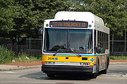
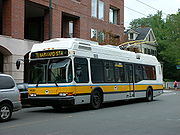 The MBTA bus
system is the nation's seventh largest by ridership and comprises over 150 routes across the Greater Boston
area. The area served by the MBTA's bus operations corresponds to that served by the subway, but is significantly smaller than that served by MBTA's commuter rail operation. Seven other regional transit authorities also provide bus services within that larger area, these being Brockton Area Transit Authority
, Cape Ann Transportation Authority
, Greater Attleboro Taunton Regional Transit Authority
, Lowell Regional Transit Authority
, Merrimack Valley Regional Transit Authority
, Montachusett Regional Transit Authority
, and Worcester Regional Transit Authority
. All of these authorities have their own fare structures and subcontract operation to private bus companies, but in many cases their buses serve as feeders to the MBTA commuter rail.
Within MBTA's bus service area, transfers from the subway are free
if using a CharlieCard
(for local buses); transfers to the subway require paying the difference between bus and the higher subway fare (for local buses; if not using a CharlieCard, full subway fare must be paid in addition to full bus fare). Bus-to-bus transfers (for local buses) are free unless paying cash. Many of the outlying routes run express along major highways to downtown. The buses are colored yellow on maps and in station decor.
The Silver Line
is the MBTA's first service designated as bus rapid transit
, even though it lacks many of the characteristics of bus rapid transit. The first segment, replacing the 49 bus, which in turn replaced the Washington Street Elevated
section of the Orange Line
, began operations in 2002, with free transfers to the subways downtown until January 1, 2007, when the fare system was revised. The "Washington Street" segment runs along various downtown streets, and mostly in dedicated bus lane
s on Washington Street
itself. It is categorized as a "bus" service for fare purposes.
The "Waterfront" section opened at the end of 2004, and connects South Station
to South Boston, partly via a tunnel and partly on the surface. These buses run dual-mode, trackless trolley
in the tunnel and diesel
bus outside. Service to Logan Airport began in June 2005. The Waterfront segment is classified as a "subway" for fare purposes.
A third, tunneled segment is proposed to connect the two lines for through service. Currently a transfer between phases is possible at South Station. "Phase 3" is controversial due to its high cost and the fact that many do not consider Phase I to be adequate replacement service for the old Elevated.
Current plans include more bus rapid transit routes, including the Urban Ring
, intended to expand upon existing Crosstown Buses.
The MBTA contracts with private bus companies to provide subsidized service on certain routes, outside of the usual fare structure. These are known collectively as the HI-RIDE Commuter Bus service, and are not numbered or mapped in the same way as integral bus services.
Four routes
connecting to Harvard Station
(Red Line) still run as trackless trolleys
; there was once a much larger trackless trolley system.
In FY2005, there were on average 363,500 weekday boardings of MBTA-operated buses and trackless trolleys (not including the Silver Line), or 31.8% of the MBTA system. Another 4,400 boardings (0.38%) occurred on subsidized bus routes operated by private carriers.
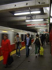
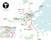 The subway system has three rapid transit
lines—the Red
, Orange
and Blue
Lines, and two light rail
lines—the Green Line
and the Ashmont–Mattapan High Speed Line (designated as part of the Red Line). The system operates according to a spoke-hub distribution paradigm
, with the lines running between central Boston and its environs. All four colored lines meet downtown at a square configuration, and the Orange and Green Lines (which run parallel) meet directly at two stations. The Red Line has two branches in the south—Ashmont
and Braintree
, named after their terminal station
s. The portion from Harvard to Park Street Under represented the city's first rapid transit subway, 1912. The Green Line has four branches in the west—"B" (Boston College
), "C" (Cleveland Circle
), "D" (Riverside
) and "E" (Heath Street
). The Green Line's underground section between Park Street Station and Boylston Street
at the Boston Common
was the first subway line in the United States, in 1897. The "A" Branch formerly went to Watertown, filling in the north-to-south letter assignment pattern, and the "E" Branch formerly continued beyond Heath Street to Arborway
. The colors were assigned on August 26, 1965 in conjunction with design standards developed by Cambridge Seven Associates
, and have served as the primary identifier for the lines since the 1964 reorganization of the MTA into the MBTA.
In FY2005, there were on average 628,400 weekday boardings on the rapid transit and light rail lines (including the Silver Line Bus Rapid Transit), or 55.0% of the MBTA system.
 The Orange Line is so named because it used to run down Orange Street (now lower Washington Street), the Green Line because it runs adjacent to parts of the Emerald Necklace
, the Blue Line because it runs under Boston Harbor
, and the Red Line because its northernmost station used to be at Harvard University
, whose school color is crimson.
The three rapid transit lines are incompatible; trains of one line would have to be modified to run on another. Orange and Blue Line trains are similar enough that modification of some Blue Line trains for operation on the Orange Line was considered, although ultimately rejected for cost reasons; some of the new Blue Line cars from Siemens Transportation
have been tested on the Orange Line after-hours before acceptance for revenue service on the Blue Line. There are no direct track connections between lines, except between the Red Line and Ashmont-Mattapan High Speed Line, but all except the Blue Line have currently unused connections to the national rail network
, which have been used for deliveries.
A segment of Green Line tunnel from Park Street opened in 1897, making it the first subway in the United States. The downtown portions of what are now the Green, Orange, Blue, and Red lines were all in service by 1912. Additions to the rapid transit network occurred in most decades of the 1900s, and continue in the 2000s with the addition of Silver Line bus rapid transit
and planned Green Line expansion. (See History and Future plans sections.)
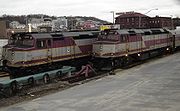
 The MBTA Commuter Rail
system is a regional rail
network that shares its tracks with inter-city passenger
and freight train
s. As of 2007, the system was composed of twelve lines, three of which have branches, and another branch provides access to Gillette Stadium
for special events in or near Foxborough
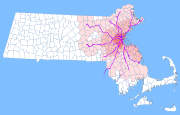
. The rail network operates according to a spoke-hub distribution paradigm
, with the lines running radially outward from the city of Boston. Eight of the lines converge at South Station
, with four of these passing through Back Bay
station. The other four converge at North Station. Amtrak
uses two of the south-side lines and one of the north-side lines for long-distance intercity service. The Commuter Rail system has used the color purple on train cars and system maps since October 8, 1974, and consequently it is sometimes called the "Purple Line."
There is no passenger connection between the two sides. The opportunity for a North–South Rail Link, in association with the burying of the Central Artery
in the Big Dig
, was furthered by designing the Big Dig tunnel to permit the construction of a rail bed below the level of the automobile roadbeds.
Passengers continue to take the Orange Line between Back Bay and North Station, or the Red and Orange, or Red and Green Lines between South and North stations, or take a bus
or taxicab
.
A south-side commuter rail line, the Greenbush Line
, recently completed construction and testing and opened for commuting on October 31, 2007. A south-side branch to Fall River
and New Bedford
is in the planning stages.
Track exists to extend the Middleborough/Lakeville Line
to restore passenger service to Cape Cod
, formerly part of the Old Colony Railroad
lines.
Each commuter rail line is divided into up to 9 fare zones (previously 10 on some lines), numbered 1A, and 1 through 8. Riders are charged based on the number of zones they travel through. Tickets can be purchased on the train or at designated ticket vendor locations near major stations, such as the Anderson Regional Transportation Center
. If a local vendor is available, riders must purchase a ticket before boarding to avoid a surcharge. Fares range from $1.70 to $7.75, with multi-ride and monthly passes available. In FY2005, there were on average 135,900 weekday boardings, which was 11.9% of the MBTA system as a whole.
The MBTA commuter rail network was the first in the nation to offer free Wi-Fi
onboard trains. MBTA recommends use of the service for simple web services. After a successful test on the Framingham/Worcester line, the MBTA has been increasing Internet connectivity for passengers. It now offers at least two wi-fi-enabled coaches per train with the hopes of adding access to the other coaches by the end of the 2010.
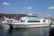 The MBTA Boat
system comprises several ferry
routes via Boston Harbor
. One of these is an inner harbor service, linking the downtown waterfront with the Boston Navy Yard
in Charlestown. The other routes are commuter routes, linking downtown to Hingham
, Hull
, Salem
and Quincy
. Some commuter services operate via Logan International Airport
.
All boat services are operated by private sector
companies under contract to the MBTA. In FY2005, the MBTA boat system carried 4,650 passengers (0.41% of total MBTA passengers) per weekday. The service is provided through contract of the MBTA by Boston Harbor Cruises (BHC) and Water Transportation Alternatives, Inc. (WTAI) under the name Boston's Best Cruises.
services carry 5,400 passengers on a typical weekday, or 0.47% of the MBTA system. Among the private sector companies under contractual agreement for The RIDE service are: Greater Lynn Senior Services (GLSS), Veterans Transportation LLC., and TTI/YCN Joint Venture, LLC.
facilities at many outlying stations, with a total capacity of almost 46,000 automobiles. The number of spaces at stations with parking varies from a few dozen to over 2,500. The larger lots and garages are usually near a major highway exit. Lots often fill up during the morning rush hour
. There are some 22,000 spaces on the southern portion of the commuter rail system, 9,400 on the northern portion and 14,600 at subway stations. The parking fee for a day was raised by $2 on November 15, 2008, to $7.00 at subway parking garages, $5.00 to $6.00 at subway surface lots, $4.00 at commuter rail surface lots, and $3.00 at commuter ferry lots. Most stations also have parking racks for bicycle
s. Management for a number of parking lots owned by the MBTA are managed by LAZ Parking Limited, LLC.
; the MBTA currently provides Zipcar with a limited number of parking spaces at various subway stations throughout the system.
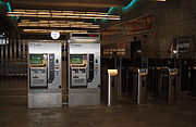
Beginning January 1, 2007, rapid transit trips (including rides on the Green Line) cost $1.70 for CharlieCard
holders, $2 for CharlieTicket or cash payers. Bus and trackless trolley fares are $1.25 for CharlieCard holders, $1.50 for others. Persons using CharlieCards can transfer free from a subway to a bus, and from a bus to a subway for the $0.45 difference in price. CharlieTicket holders can transfer free between buses, but not from a subway to a bus. Cash payers may only transfer between subway lines, as well as to and from the Silver Line Washington Street, since it's considered Bus Rapid Transit. (Example: Can transfer from Red to Silver Line at South Station; Can transfer from Green to Silver at Boylston St; Cannot transfer from Green Line to #1 bus at Hynes)
Discounted fares ($0.60 for the subway and $0.40 for local buses) as well as discounted monthly link passes are available to seniors over 65, and persons who are permanently disabled who utilize a special photo Charlie Card (called "Senior ID" and "Transportation Access Pass", respectively). Holders of these passes are also entitled to 50% off the Commuter Rail. Persons who are legally blind ride for free on all MBTA services (including express buses and the Commuter Rail) with Blind Access Card.
Children 11 and under ride for free with an adult, and students aged 12–17 receive a 50% discount on fares (or a monthly link pass for $20) until 11 pm on school days. Student discounts require a Student Charlie Card issued through the holder's school and is good until around the time when school vacation begins.
The MBTA began collecting fares for outbound trips originating on the surface part of the Green Line on January 1, 2007. The 2007 fare increase also eliminated exit fares at certain Red Line stops and ended higher fares at inbound stops on the outer part of the Green Line "D" Branch.
Monthly passes have been in use since the late 1980s. The MBTA also sells one- and seven-day passes intended for use by visitors. These visitor passes begin from the exact time of purchase at the vending machine. However, for large orders, these visitor passes can be ordered with an exact date if purchased through the MBTA bulk sales in advance.
The fare system, including on-board and in-station fare vending machines, was purchased from German
-based Scheidt and Bachmann, which developed the technology. The Charlie Cards were developed by Gemalto and later by Giesecke & Devrient.
Since the "forward funding" reform in 2000, the MBTA is funded primarily through 1% of the 6.25% state sales tax (with minimum dollar amount guarantee), passenger fares, and formula assessments of the cities and towns in its service area (excepting those which are assessed for the MetroWest Regional Transit Authority
). Supplemental income is obtained from its parking lots (reserved for passengers), renting space to retail vendors in and around stations, rents from utility companies using MBTA rights of way, selling surplus land and movable property, advertising on vehicles and properties, and federal operating subsidies for special programs.
The FY2008 budget includes $1,037M for operating expenses and $374M in debt and lease payments.
The Capital Investment Program is a rolling 5-year plan which programs capital expenses. The draft FY2009-2014 CIP allocates $3,795M, including $879M in projects funded from non-MBTA state sources (required for Clean Air Act
compliance), and $299M in projects with one-time federal funding from the American Recovery and Reinvestment Act of 2009
. Capital projects are paid for by federal grants, allocations from the general budget of the Commonwealth of Massachusetts (for legal commitments and expansion projects) and MBTA bonds (which are paid off through the operating budget).
The FY2010 budget was supplemented by $160 million in sales tax revenue when the statewide rate was raised from 5% to 6.25%, to avoid service cuts or a fare increase in a year when deferred debt payments were coming due.
is responsible for overall regional surface transportation planning. As required by federal law for projects to be eligible for federal funding (except earmark
s), the MPO maintains a fiscally constrained 20+ year Regional Transportation Plan for surface transportation expansion, the current edition of which is called Journey to 2030. The required 4-year MPO plan is called the Transportation Improvement Plan.
The MBTA maintains its own 25-year capital planning document, called the Program for Mass Transportation, which is fiscally unconstrained. The agency's 4-year plan is called the Capital Improvement Plan; it is the primary mechanism by which money is actually allocated to capital projects. Major capital spending projects must be approved by the MBTA Board, and except for unexpected needs, are usually included in the initial CIP.
In addition to federal funds programmed through the Boston MPO, and MBTA capital funds derived from fares, sales tax, municipal assessments, and other minor internal sources, the T receives funding from the Commonwealth of Massachusetts for certain projects. The state may fund items in the State Implementation Plan
(SIP) - such as the Big Dig mitigation projects - which is the plan required under the Clean Air Act
to reduce air pollution. (As of 2007, all of Massachusetts is designated as a clean air "non-attainment" zone.)
In 2005, the administration of then-governor Mitt Romney
announced a long range transportation plan that emphasized repair and maintenance over expansion.
Due to the financial constraints on the MBTA budget, it is expected that funds for all further expansion projects will be funded with money outside the MBTA's budget. A state transportation bond bill is currently being used to fund the Green Line extension to Somerville
and Medford
, and planning for commuter rail service to Fall River
and New Bedford
.
, with two potential extension routes having been identified. One proposed path would run through marshland alongside the existing Newburyport/Rockport commuter rail line
, while the other would extend the line along the remainder of the BRB&L
right of way. Construction is expected to begin in 2017.
In addition, the MBTA has committed to designing an extension of the line's southern terminus westward to Charles/MGH
, where it would connect with the Red Line
. This was one of the mitigation measures the Commonwealth of Massachusetts agreed to as part of the Big Dig
.
to mitigate increased automobile emissions from the Big Dig
, the Commonwealth of Massachusetts agreed to extend the Green Line north to Somerville
and Medford
, two suburbs currently underserved by the MBTA. This plan would start at a relocated Lechmere Station
, and terminate at Route 16
and Mystic Valley Parkway
in Somerville (on the Mystic River
), by the settlement-imposed deadline of December 31, 2014. There will be an expected daily ridership of 8,420.
Another mitigation project in the initial settlement was restoration of service on the "E" Branch between Heath Street
and Arborway/Forest Hills
. A revised settlement agreement resulted in the substitution of other projects with similar air quality benefits. The state Executive Office of Transportation promised to consider other transit enhancements in the Arborway corridor.
is a planned new station on the MBTA's Orange Line
. No new rail trackage will be added, since the Orange Line already runs through the site, but a new platform will be added to allow passengers to board and disembark. The new station is tentatively scheduled to begin construction in 2011, and to open in 2013. It is being built alongside the planned Assembly Square
project (which is also located right next to the Assembly Square Marketplace
).
Phase III comprises the connection of the two halves of the Silver Line via an underground busway from Boylston station
on the Green Line to South Station
. An initial proposed route involved a mile long tunnel connecting separate portals located at Charles and at Tremont
streets. http://www.boston.com/news/local/articles/2006/03/10/officials_endorse_silver_line_tunnel/?page=full The local Tufts Medical Center
has vehemently protested this proposal, citing possible problems with traffic and noise. Environmental review and preliminary engineering were expected to be completed by the end of 2008. A federal funding decision was expected in 2010, with possible construction starting in 2011 and ending in 2016. The MBTA has been managing project planning. As of 2010, planning and construction of the Phase III tunnel has been suspended indefinitely (without any physical construction having begun) due to funding difficulties and community opposition.
is a project of the Massachusetts Bay Transportation Authority and the Commonwealth of Massachusetts
, to develop new public transport
ation routes that would provide improved circumferential connections among many existing transit lines that project radially from downtown Boston
, allowing easier travel between locations outside of downtown. The project corridor passes through various neighborhoods of Boston, Chelsea
, Everett
, Malden
, Medford
, Somerville
, Cambridge
, and Brookline
. The capital cost for this version of the plan is estimated at $2.2 billion, with a projected daily ridership of 170,000. Fifty-three percent of the route is either in a bus-only lane, dedicated busway, or tunnel. The Urban Ring would have a higher collective ridership than the Orange Line, Blue Line, or the entire commuter rail system.
is proposed to Fall River
, and New Bedford
.
Critics argue that building the extension does not make economic sense.
A 20 miles (32.2 km) extension of the Providence Line
is under construction past Providence
to T. F. Green Airport
and Wickford Junction
in Rhode Island
. The T. F. Green Airport part of the extension is operating, with the Wickford part expected to start operating in 2011. The Rhode Island Department of Transportation
is also studying the feasibility of serving existing Amtrak stations in Kingston and Westerly
as well as constructing new stations in Cranston
, East Greenwich
, and West Davisville
. Federal funding has also been provided for preliminary planning of a new station in Pawtucket
.
In September 2009, CSX Transportation
and the commonwealth finalized a $100 million agreement to purchase CSX's Framingham
to Worcester
tracks, as well as some other track, to improve service on the Framingham/Worcester Line. A liability issue that had held up the agreement was resolved. There is also a plan to upgrade the Fitchburg Line
to have cab signaling and to construct a second track along a seven-mile (11 km) stretch near Acton
which is shared with freight traffic, so that the Fitchburg
to Boston trip will be able to take only about an hour.
The state of New Hampshire
created the New Hampshire Rail Authority and allocated money to build platforms at Nashua
and Manchester
.
An article in The Eagle-Tribune claims that Massachusetts is negotiating to buy property which has the potential to extend the Haverhill Line to Plaistow, New Hampshire
.
The Commonwealth of Massachusetts agreed in 2005 to make improvements on the Fairmount Line
part of its legally binding commitment to mitigate increased air pollution from the Big Dig
. These improvements must be complete by December 31, 2011. Four new stations will be constructed.
The total cost of the project is estimated at $79.4 million, and will divert 220 trips from automobiles to transit.
No direct connection exists between North Station and South Station. A North–South Rail Link has been proposed to unite the two halves of the commuter rail system; but, because of the high cost, Massachusetts has withdrawn its sponsorship of the proposal, in communications with the United States Department of Transportation
.
Cabinet. The MBTA's executive management team is led by its General Manager, who is currently also serving as the MassDOT Rail and Transit Administrator, overseeing all public transit in the state.
The MBTA Advisory Board represents the cities and towns in the MBTA service district. The municipalities are assessed a total of $143M annually (as of FY2008). In return, the Advisory Board has veto power over the MBTA operating and capital budgets, including the power to reduce the overall amount.
The MBTA's Board of Directors should not be confused with a separate Board of Directors for MBCR.
(The same five appointees also serve as the Board of Directors for the Massachusetts Department of Transportation.)
Other key people
and South Shores being represented in addition to Metro-Boston
. These garages are:
Rail lines have their own maintenance facilities:
Major administrative facilities:
Structurally, the employees of the MBTA function as part of a handful of trade union
s. The largest union of the MBTA is the Carmen’s Union (Local 589), representing bus and subway operators. This includes full and part-time bus drivers, motorpersons and streetcar motorpersons, full and part-time train attendants, and Customer Service Agents (CSAs). Further unions include the Machinists Union, Local 264; Electrical Workers Union, Local 717; the Welder's Union, Local 651; the Executive Union; the Office and Professional Employees International Union, Local 453; the Professional and Technical Engineers Union, Local 105; and the Office and Professional Employees Union, Local 6.
Within the authority, employees are ranked according to seniority
(or "rating"). This is categorized by an employee's five-digit badge number, though some of the longest serving employees still have only four-digits. An employee's badge number indicates the relative length of employment with the MBTA; badges are issued in sequential order. The rating structure determines many different things, including the rank in which perks are to be offered to employee, such as: When offering the choice for quarter-annual route assignments ("picks"), overtime offerings, and even the rank to transfer new hires from part-time roles to a full time role.
The MBTA also maintains several closed-circuit television
facilities located throughout its service area. The cameras monitor various areas including trains stations, and MBTA vehicles throughout the system on a 24-hour basis. MBTA phone numbers pasted onto the front of the fare gates can place customers having a problem directly into contact with one of these operations centers.
of over US$ 8 billion. As a direct result, MBTA fares and parking fees have increased significantly.
In July 2009 the MBTA proposed a 20% fare increase and significant service cuts. The MBTA has endured criticism that the increases have outpaced inflation.
When the Orange Line was realigned in the 1980s, its course was altered away from the lower income areas of Everett
, Chelsea
and Roxbury, where residents are less likely to own cars, and depend more on public transit, toward the more affluent towns of Malden
and Medford
, as well as sections of the Jamaica Plain neighborhood (where car ownership is higher, and thus, reliance on public transit is far lower). In response, the MBTA built a bus line operated by articulated silver buses equipped with specialized dispatching equipment. The MBTA named the service the Silver Line
, and classified it as though it were a rail transit service. The service has been criticized in many respects, most notably for its slow speed, and the fact that it utilizes the same roads as cars and other "street" traffic, subsequently increasing gridlock and collisions, earning it the nickname "Silver Lie" among many.
Transportation advocates in Boston have raised the issue that residents cannot go from one outlying area to another without first riding downtown and changing lines. The Urban Ring Project
, which would provide more circumferential service, is in the planning stages and has largely not yet been implemented due to lack of funding. This problem also occurs in the Washington Metro
system, where customers cannot travel between suburbs on the same side of Washington
without going through downtown, and Chicago
's Metra
and CTA
systems, where all lines lead into and out of the central business district, rather than around it.
The T stops running at 12:45 a.m. each night, despite the fact that bars and clubs in most areas of Boston are open until 2 a.m. Like nearly all subways worldwide, the MBTA's subway does not have parallel express and local tracks, so rail maintenance can only be done when the T is not running, and "with a 109-year-old system", says the MBTA press secretary, "you have to be out there every night." The T did experiment with "Night Owl" bus service from 2001 to 2005, but abandoned it on account of the $7.53 per rider cost to the MBTA to keep the service open, five times the cost per passenger of an average bus route.
Bus
A bus is a road vehicle designed to carry passengers. Buses can have a capacity as high as 300 passengers. The most common type of bus is the single-decker bus, with larger loads carried by double-decker buses and articulated buses, and smaller loads carried by midibuses and minibuses; coaches are...
, subway
Rapid transit
A rapid transit, underground, subway, elevated railway, metro or metropolitan railway system is an electric passenger railway in an urban area with a high capacity and frequency, and grade separation from other traffic. Rapid transit systems are typically located either in underground tunnels or on...
, commuter rail and ferry
Ferry
A ferry is a form of transportation, usually a boat, but sometimes a ship, used to carry primarily passengers, and sometimes vehicles and cargo as well, across a body of water. Most ferries operate on regular, frequent, return services...
systems in the greater Boston
Boston
Boston is the capital of and largest city in Massachusetts, and is one of the oldest cities in the United States. The largest city in New England, Boston is regarded as the unofficial "Capital of New England" for its economic and cultural impact on the entire New England region. The city proper had...
, Massachusetts
Massachusetts
The Commonwealth of Massachusetts is a state in the New England region of the northeastern United States of America. It is bordered by Rhode Island and Connecticut to the south, New York to the west, and Vermont and New Hampshire to the north; at its east lies the Atlantic Ocean. As of the 2010...
, area. Officially a "body politic and corporate, and a political subdivision" of the Commonwealth of Massachusetts,
it was formed in 1964. Its immediate predecessor, the Metropolitan Transit Authority (MTA), was immortalized by The Kingston Trio
The Kingston Trio
The Kingston Trio is an American folk and pop music group that helped launch the folk revival of the late 1950s to late 1960s. The group started as a San Francisco Bay Area nightclub act with an original lineup of Dave Guard, Bob Shane, and Nick Reynolds...
in the popular folk-protest lament "M.T.A." Locals call it simply "The T", after its logo, the letter T in a circle, adopted in the 1960s and inspired by the Stockholm Metro
Stockholm Metro
The Stockholm Metro is a metro system in Stockholm, Sweden. The first line opened in 1950, and today the system has 100 stations in use, of which 47 are underground and 53 above ground. There are seven lines numbered from 10 to 19, in three groups identified by a color: the Green, Red and Blue lines...
. In 2008, the system averaged 1.3 million passenger trips each weekday, of which the subway averaged 598,200, making it the fourth busiest subway system in the United States
United States
The United States of America is a federal constitutional republic comprising fifty states and a federal district...
.
The Green Line
Green Line (MBTA)
The Green Line is a streetcar system run by the Massachusetts Bay Transportation Authority in the Boston, Massachusetts area of the United States. It is the oldest line of Boston's subway, which is known locally as the 'T'. The Green Line runs underground downtown and on the surface in outlying...
and Ashmont–Mattapan High Speed Line of the T comprise the busiest light-rail system in the U.S, with a weekday ridership of 255,100.
The MBTA also operates an independent law enforcement agency, the Massachusetts Bay Transportation Authority Police
Massachusetts Bay Transportation Authority Police
The Massachusetts Bay Transportation Authority Police is a police force which has primary jurisdiction on Massachusetts Bay Transportation Authority property and vehicles in each of the 178 cities and towns within the MBTA District. The department has grown to an authorized strength of 266...
. In 2006, 31.60% of workers in the city proper
City limits
The terms city limits and city boundary refer to the defined boundary or border of a city. The area within the city limits is sometimes called the city proper. The terms town limits/boundary and village limits/boundary mean the same as city limits/boundary, but apply to towns and villages...
commuted by public transport
Public transport
Public transport is a shared passenger transportation service which is available for use by the general public, as distinct from modes such as taxicab, car pooling or hired buses which are not shared by strangers without private arrangement.Public transport modes include buses, trolleybuses, trams...
.
The MBTA is one of only two U.S. transit agencies that operate all of the five major types of transit vehicles: regional (commuter) rail trains, "heavy" rapid transit (subway/elevated) trains, light rail vehicles (trolleys), electric trolleybuses and motor buses. The other is Philadelphia's Southeastern Pennsylvania Transportation Authority (SEPTA).
The MBTA is the largest consumer of electricity in Massachusetts,
and the second-largest land owner after the Department of Conservation and Recreation
Department of Conservation and Recreation (Massachusetts)
The Department of Conservation and Recreation is a state agency of the Commonwealth of Massachusetts, situated in the Executive Office of Energy and Environmental Affairs. It is best known for its parks and parkways. As of May 24, 2011 the Commissioner of the DCR is Edward M. Lambert, Jr...
.
As of 2007, its CNG bus fleet was the largest consumer of alternative fuels in the state.
On June 26, 2009, Governor Deval Patrick
Deval Patrick
Deval Laurdine Patrick is the 71st and current Governor of Massachusetts. A member of the Democratic Party, Patrick served as an Assistant United States Attorney General under President Bill Clinton...
signed a law to place the MBTA along with other state transportation agencies within the administrative authority of the Massachusetts Department of Transportation (MassDOT), with the MBTA now part of the Mass Transit division (MassTrans).
The 2009 transportation law continued the MBTA corporate structure and changed the MBTA board membership to the five Governor-appointed members of the Mass DOT Board.
History
Mass transportation in Boston was provided by private companies, often granted charters by the state legislature for limited monopolies
Monopoly
A monopoly exists when a specific person or enterprise is the only supplier of a particular commodity...
, with powers of eminent domain
Eminent domain
Eminent domain , compulsory purchase , resumption/compulsory acquisition , or expropriation is an action of the state to seize a citizen's private property, expropriate property, or seize a citizen's rights in property with due monetary compensation, but without the owner's consent...
to establish a right-of-way
Right-of-way (railroad)
A right-of-way is a strip of land that is granted, through an easement or other mechanism, for transportation purposes, such as for a trail, driveway, rail line or highway. A right-of-way is reserved for the purposes of maintenance or expansion of existing services with the right-of-way...
, until the creation of the MTA in 1947. Development of mass transportation followed both existing economic and population patterns, and helped shape those patterns.
Railways
Shortly after the steam locomotiveSteam locomotive
A steam locomotive is a railway locomotive that produces its power through a steam engine. These locomotives are fueled by burning some combustible material, usually coal, wood or oil, to produce steam in a boiler, which drives the steam engine...
became practical for mass transportation, the private Boston and Lowell Railroad
Boston and Lowell Railroad
The Boston and Lowell Railroad is a historic railroad that operated in Massachusetts. It was one of the first railroads in North America and the first major one in the state...
was chartered in 1830, connecting Boston to Lowell
Lowell, Massachusetts
Lowell is a city in Middlesex County, Massachusetts, USA. According to the 2010 census, the city's population was 106,519. It is the fourth largest city in the state. Lowell and Cambridge are the county seats of Middlesex County...
, a major northerly mill town
Mill town
A mill town, also known as factory town or mill village, is typically a settlement that developed around one or more mills or factories .- United Kingdom:...
, via one of the oldest railroads in North America
Oldest railroads in North America
- Early experimental railroads :*1720: A railroad is reportedly used in the construction of the French fortress at Louisburg, Nova Scotia.*1764: Between 1762 and 1764 a gravity railroad is built by British military engineers at the Niagara Portage in Lewiston, New York.*1795: A wooden railway on...
. This marked the beginning of the development of American intercity railroads, which in Massachusetts would later become the MBTA Commuter Rail system and the Green Line "D" Branch.
Streetcars
Starting with the opening of the Cambridge RailroadCambridge Railroad
The Cambridge Railroad was the first street railway in the Boston, Massachusetts area, linking Harvard Square in Cambridge to Cambridge Street and Grove Street in Boston's West End, via Massachusetts Avenue, Main Street and the West Boston Bridge....
on March 26, 1856, a profusion of streetcar lines appeared in Boston under chartered companies. Therefore, in spite of changes of the companies, Boston is the city with the oldest continuously working streetcar system in the world. Later, many of these companies consolidated, and animal-drawn vehicles were converted to electric propulsion.
Subways and elevated railways
Streetcar congestion in downtown Boston led to the establishment of subwayRapid transit
A rapid transit, underground, subway, elevated railway, metro or metropolitan railway system is an electric passenger railway in an urban area with a high capacity and frequency, and grade separation from other traffic. Rapid transit systems are typically located either in underground tunnels or on...
s and elevated rail, the former established in 1897 and the latter in 1901, resulting in the Tremont Street Subway
Tremont Street Subway
The Tremont Street Subway is a tunnel in Boston's subway system, and is the oldest subway tunnel in North America, opening on September 1, 1897. It was originally built as a tunnel to get streetcar lines off the streets, rather than a rapid transit line...
, the first active subway in the United States. These grade-separated railways both added additional transportation capacity and avoided delays caused by intersections with cross streets.
The first elevated railway and the first rapid transit line in Boston came three years before the first underground line of the New York City Subway
New York City Subway
The New York City Subway is a rapid transit system owned by the City of New York and leased to the New York City Transit Authority, a subsidiary agency of the Metropolitan Transportation Authority and also known as MTA New York City Transit...
, but 34 years after the first London Underground
London Underground
The London Underground is a rapid transit system serving a large part of Greater London and some parts of Buckinghamshire, Hertfordshire and Essex in England...
lines, and long after the first elevated railway in New York.
Buses
The Boston Elevated Railway started replacing rail vehicles with busBus
A bus is a road vehicle designed to carry passengers. Buses can have a capacity as high as 300 passengers. The most common type of bus is the single-decker bus, with larger loads carried by double-decker buses and articulated buses, and smaller loads carried by midibuses and minibuses; coaches are...
es in 1922. In 1936, it started replacing some rail vehicles with trackless trolleys. The last Middlesex and Boston Street Railway
Middlesex and Boston Street Railway
The Middlesex and Boston Street Railway was a streetcar and later bus company in the area west of Boston, Massachusetts. Streetcars last ran in 1930, and in 1972 the company's operations were merged into the Massachusetts Bay Transportation Authority .-History:The company was first chartered as...
streetcar ran in 1930. By the beginning of 1953, the only remaining streetcar lines
Boston-area streetcar lines
As with many large cities, a large number of Boston-area streetcar lines once existed. However, only a few remain, namely the four branches of the Green Line and the Ashmont-Mattapan High Speed Line, with only one running regular service on an undivided street.The Massachusetts Bay Transportation...
fed two tunnels - the main Tremont Street Subway
Tremont Street Subway
The Tremont Street Subway is a tunnel in Boston's subway system, and is the oldest subway tunnel in North America, opening on September 1, 1897. It was originally built as a tunnel to get streetcar lines off the streets, rather than a rapid transit line...
network downtown and the short tunnel (now the Harvard Bus Tunnel) in Harvard Square
Harvard Square
Harvard Square is a large triangular area in the center of Cambridge, Massachusetts, United States, at the intersection of Massachusetts Avenue, Brattle Street, and John F. Kennedy Street. It is the historic center of Cambridge...
.
Public enterprise
The old elevated railways proved to be an eyesore and required several sharp curves in Boston's twisty streets. The Atlantic Avenue ElevatedAtlantic Avenue Elevated
The Atlantic Avenue Elevated was an elevated railway around the east side of downtown Boston, Massachusetts, providing a second route for the Boston Elevated Railway's Main Line around the Washington Street Tunnel...
was closed in 1938 amidst declining ridership and was demolished in 1942. As rail passenger service became increasingly unprofitable, largely due to rising automobile
Automobile
An automobile, autocar, motor car or car is a wheeled motor vehicle used for transporting passengers, which also carries its own engine or motor...
ownership, government takeover prevented abandonment and dismantlement of the systems. The MTA purchased and took over subway, elevated, streetcar, and bus operations from the Boston Elevated Railway
Boston Elevated Railway
The Boston Elevated Railway was a precursor first to the Metropolitan Transit Authority in Massachusetts, now the Massachusetts Bay Transportation Authority, operating rapid transit, streetcars and buses in the Boston, Massachusetts area. It was formerly known as the West End Street Railway.The...
in 1947.
In the 1950s, the MTA ran new subway extensions, while the last two streetcar lines running into the Pleasant Street Portal of the Tremont Street Subway
Tremont Street Subway
The Tremont Street Subway is a tunnel in Boston's subway system, and is the oldest subway tunnel in North America, opening on September 1, 1897. It was originally built as a tunnel to get streetcar lines off the streets, rather than a rapid transit line...
were substituted with buses in 1953 and 1962.
On August 3, 1964, the MBTA succeeded the MTA, with an enlarged service area. The original MTA district of 14 cities and towns was expanded to 78 cities and towns. The MBTA was formed partly to subsidize existing commuter rail operations. As this happened, the MBTA acquired lines in stages from 1973 through 1976 amidst large cutbacks in service and coverage area. Since then, many of these lines have seen service return.
The MBTA assigned colors to its four rapid transit lines in 1965, and lettered the branches of the Green Line from north to south. However, shortages of streetcars, among other factors, caused bus substitution of rail service on two branches of the Green Line. The "A" Branch ceased operating in 1969 as a rail service. The portion of the "E" Branch from Heath Street
Heath Street (MBTA station)
Heath Street, announced as Heath Street/VA Medical Center, is the last stop of the MBTA Green Line's E branch located along South Huntington Avenue on the Mission Hill/Jamaica Plain neighborhood line of Boston, Massachusetts...
to Arborway
Forest Hills (MBTA station)
Forest Hills Station is a station on the MBTA Orange Line, located in Forest Hills in the southern part of the Jamaica Plain neighborhood of Boston, Massachusetts at the intersections of Washington Street, Hyde Park Avenue, South Street, The Arborway and Morton Street.Forest Hills is the southern...
was replaced by buses in 1985.
The MBTA purchased bus routes in the outer suburbs to the north and south from the Eastern Massachusetts Street Railway
Eastern Massachusetts Street Railway
The Eastern Massachusetts Street Railway was a streetcar and later bus company in eastern Massachusetts, serving most suburbs of Boston, Massachusetts...
in 1968. As with the commuter rail system, many of the outlying routes were dropped shortly before or after the takeover due to low ridership and high operating costs.
In the 1970s, the MBTA received a boost from the Boston Transportation Planning Review
Boston Transportation Planning Review
Boston Transportation Planning Review is a transportation planning program for metropolitan Boston, United States which was responsible for analyzing and re-designing the entire area-wide transit and highway system in the 1970s. The major contractors involved were Alan M...
areawide re-evaluation of the role of mass transit relative to highways. Producing a moratorium on highway construction inside Route 128, numerous mass transit lines were planned for expansion by the Voorhees-Skidmore, Owings and Merrill-ESL consulting team. The removal of elevated lines continued, and the closure of the Washington Street Elevated
Washington Street Elevated
The Washington Street Elevated was an elevated segment of Boston's Massachusetts Bay Transportation Authority subway system, comprising the southern stretch of the Orange Line . It ran from Chinatown through the South End and Roxbury, ending in Forest Hills in Jamaica Plain...
brought the end of rapid transit service to the Roxbury neighborhood. Between 1971 and 1985, the Red Line
Red Line (MBTA)
The Red Line is a rapid transit line operated by the MBTA running roughly north-south through Boston, Massachusetts into neighboring communities. The line begins west of Boston, in Cambridge, Massachusetts at Alewife station, near the intersection of Alewife Brook Parkway and Route 2...
was extended both north and south, providing not only additional subway system coverage, but also major parking structures at several of the terminal and intermediate stations.
In the 21st century
By 1999, the district was expanded further to 175 cities and towns, adding most that were served by or adjacent to commuter rail lines, though the MBTA did not assume responsibility for local service in those communities adjacent to or served by commuter rail.Sales tax
A sales tax is a tax, usually paid by the consumer at the point of purchase, itemized separately from the base price, for certain goods and services. The tax amount is usually calculated by applying a percentage rate to the taxable price of a sale....
. The MBTA now must live within this "forward funding" budget.
The Commonwealth assigned to the MBTA responsibility for increasing public transit to compensate for increased automobile pollution from the Big Dig
Big Dig
The Central Artery/Tunnel Project , known unofficially as the Big Dig and as the Big Dug since completion, was a megaproject in Boston that rerouted the Central Artery , the chief highway through the heart of the city, into a 3.5-mile tunnel...
. The T submerged a nearby portion of the Green Line and rebuilt Haymarket
Haymarket (MBTA station)
Haymarket is a MBTA station on the Green and Orange lines, located at the corner of Congress and New Sudbury Street. Transfer between the Green and Orange Lines is possible here, although the adjacent North Station may be more convenient for some cross-platform transfers.Originally, the Orange...
and North Stations during Big Dig construction. However, these projects have strained the MBTA's limited resources, since the Big Dig project did not include funding for these improvements. Since 1988, the MBTA has been the fastest expanding transit system in the country, even as Greater Boston
Greater Boston
Greater Boston is the area of the Commonwealth of Massachusetts surrounding the city of Boston. Due to ambiguity in usage, the size of the area referred to can be anywhere between that of the metropolitan statistical area of Boston and that of the city's combined statistical area which includes...
has been the slowest growing metropolitan area.
When, in 2000, the MBTA's budget became limited, the agency began to run into debt from scheduled projects and obligatory Big Dig remediation work, which have now given the MBTA the highest debt of any transit authority in the country. In an effort to compensate, rates underwent an appreciable hike on January 1, 2007. Increasingly, local advocacy groups are calling on the state to assume $2.9 billion of the authority's now approximate debt of $9 billion, the interest on which severely limits funds available for required projects.
With the 2004 replacement of the Causeway Street Elevated
Causeway Street Elevated
The Causeway Street Elevated was a part of the MBTA's Green Line in Boston, Massachusetts that ran roughly northwards from Haymarket, then ran westwards for a short distance around the Boston Garden indoor sports venue's exterior through the Green Line's North Station stop, and resumed a...
with a subway connection, the only remaining elevated railway
Rapid transit
A rapid transit, underground, subway, elevated railway, metro or metropolitan railway system is an electric passenger railway in an urban area with a high capacity and frequency, and grade separation from other traffic. Rapid transit systems are typically located either in underground tunnels or on...
s are a short portion of the Red Line
Red Line (MBTA)
The Red Line is a rapid transit line operated by the MBTA running roughly north-south through Boston, Massachusetts into neighboring communities. The line begins west of Boston, in Cambridge, Massachusetts at Alewife station, near the intersection of Alewife Brook Parkway and Route 2...
at Charles/MGH
Charles/MGH (MBTA station)
Charles/MGH Station also known as Charles or Charles Street, is located at the intersection of Cambridge Street and Charles Street, in Boston, Massachusetts. The rapid transit station is on the MBTA Red Line and is elevated, being located at the Boston side of the Longfellow Bridge, which carries...
, the stretch of Red Line
Red Line (MBTA)
The Red Line is a rapid transit line operated by the MBTA running roughly north-south through Boston, Massachusetts into neighboring communities. The line begins west of Boston, in Cambridge, Massachusetts at Alewife station, near the intersection of Alewife Brook Parkway and Route 2...
between Andrew Station (once the train exits the tunnel beyond Andrew Station going southbound) and proceeding southbound to either Ashmont Station on the Ashmont line or Braintree Station on the Braintree line, and a short portion of the Green Line
Green Line (MBTA)
The Green Line is a streetcar system run by the Massachusetts Bay Transportation Authority in the Boston, Massachusetts area of the United States. It is the oldest line of Boston's subway, which is known locally as the 'T'. The Green Line runs underground downtown and on the surface in outlying...
between Science Park
Science Park (MBTA station)
Science Park, signed as Science Park/West End, is a station on the MBTA Green Line and is located at the Boston end of the Old Charles River Dam at Leverett Circle, near the intersection of Nashua Street and Charles Street . The station is located on the elevated Lechmere Viaduct, which connects...
and Lechmere
Lechmere (MBTA station)
Lechmere is the northern terminus of the MBTA Green Line. It is located in Lechmere Square in East Cambridge, Massachusetts, near the intersection of Cambridge Street and Monsignor O'Brien Highway . The tracks make a loop at Lechmere, with a small yard...
.
In 2006, the creation of the MetroWest Regional Transit Authority
MetroWest Regional Transit Authority
The MetroWest Regional Transit Authority is a regional public transit authority in the state of Massachusetts providing bus and paratransit service to eleven communities in the Boston MetroWest. The MWRTA was formed in 2006 and began service on July 1, 2007 with the purpose of filling a void in...
saw Framingham
Framingham, Massachusetts
Framingham is a New England town in Middlesex County, Massachusetts, United States. The population was 68,318 as of the United States 2010 Census. -History:...
, Natick
Natick, Massachusetts
Natick is a town in Middlesex County, Massachusetts, United States. Natick is located near the center of the MetroWest region of Massachusetts, with a population of 33,006 at the 2010 census. Only west from Boston, Natick is considered part of the Greater Boston area...
, Weston
Weston, Massachusetts
Weston is a suburb of Boston located in Middlesex County, Massachusetts, United States in the Boston metro area. The population of Weston, according to the 2010 U.S. Census, is 11,261....
, Sudbury
Sudbury, Massachusetts
Sudbury is a town in Middlesex County, Massachusetts, United States, population 17,659. The town was incorporated in 1639, with the original boundaries including what is now Wayland. Wayland split from Sudbury in 1780. When first incorporated, it included and parts of Framingham, Marlborough, Stow...
, Wayland
Wayland, Massachusetts
Wayland is a town in Middlesex County, Massachusetts, United States. The population was 12,994 at the 2010 census.For geographic and demographic information on Cochituate, which is part of Wayland, please see the article Cochituate, Massachusetts.-History:...
, Marlborough
Marlborough, Massachusetts
Marlborough is a city in Middlesex County, Massachusetts, United States. The population was 38,499 at the 2010 census. Marlborough became a prosperous industrial town in the 19th century and made the transition to high technology industry in the late 20th century after the construction of the...
, Ashland
Ashland, Massachusetts
Ashland is a town in Middlesex County, Massachusetts, United States. It is part of the MetroWest region. The population was 16,593 at the 2010 census.-History:...
, Sherborn
Sherborn, Massachusetts
Sherborn is a town in Middlesex County, Massachusetts, United States. It is in area code 508 and has the ZIP code 01770. As of the 2010 U.S. Census, the town population was 4,119. The assessed value of the town for the fiscal year 2005 is $1,008,146,994....
, Hopkinton
Hopkinton, Massachusetts
Hopkinton is a town in Middlesex County, Massachusetts, just under 30 miles west and south of Boston. The town is best known as the starting point of the Boston Marathon, held annually on Patriots' Day in April, and as the home of computer storage firm EMC Corporation.For geographic and demographic...
, Holliston
Holliston, Massachusetts
Holliston is a town in Middlesex County, Massachusetts, United States in the Greater Boston area. The population was 13,547 at the 2010 census. It is part of the region known as MetroWest. Holliston is the only town in Middlesex County that borders both Norfolk and Worcester...
, and Southborough
Southborough, Massachusetts
Southborough is an affluent town in Worcester County, Massachusetts, United States. It incorporates the smaller villages of Cordaville, Fayville, and Southville. Its name is often informally shortened to Southboro, a usage seen on many area signs and maps. Its population was 9,767 at the 2010...
subtract their MWRTA assessment from their MBTA assessment. Communities that are also members of other RTAs such as CATA, MVRTA, LRTA, WRTA, GATRA, and BAT may also subtract their RTA assessment from their MBTA assessment. The amount of funding the MBTA received remained the same; the assessment on remaining cities and towns increased but is still allocated by the same formula.
The General Manager, Daniel Grabauskas, revealed in 2008 that the MBTA cut trips from published train and bus schedules without informing passengers, referred to as “hidden service cuts”, saying this misrepresentation of service had been happening for years. Grabauskas said this practice has been ended.
On October 31, 2007 the MBTA reestablished commuter rail service to the Greenbush section
Greenbush Line
The Greenbush Line is a branch of the MBTA Commuter Rail system. The line restores service along the New Haven Railroad's Greenbush Branch, from downtown Boston, Massachusetts through the towns of Braintree, Weymouth, Hingham, Cohasset, and Scituate on the South Shore of Boston...
of Scituate
Scituate, Massachusetts
Scituate is a seacoast town in Plymouth County, Massachusetts, United States, on the South Shore, midway between Boston and Plymouth. The population was 18,133 at the 2010 census....
, the third branch of the Old Colony service.
Rail renovation on the Green Line "D" Branch took place in the summer of 2007. New, low-floor cars on the line were introduced on December 1, 2008.
On May 28, 2008, a westbound trolley on the Green Line "D" Branch slammed into a stopped train between the Waban
Waban (MBTA station)
Waban is a surface-level rapid transit station on the Green Line "D" Branch of the Massachusetts Bay Transportation Authority. It is located just south of Beacon Street at Waban Square, in the Waban section of Newton, Massachusetts. The station opened on July 4, 1959. Unlike many other T stops in...
and Woodland
Woodland (MBTA station)
Woodland is a street-level station on the "D" branch of the MBTA Green Line. The station is located at 1940 Washington Street in Newton. The station is 42 minutes away from Park Street...
stations shortly after 6 p.m. At least seven people were injured, and the operator of the moving train, identified as Terrese Edmonds, 24, was killed.
On May 8, 2009, two Green Line trolleys collided between Park Street
Park Street (MBTA station)
Park Street is a rapid transit and light rail station of the MBTA subway system in Downtown Boston. One of the four subway hub stations, Park Street is a transfer point between the Green and Red Lines. Park Street is the fourth-busiest station in the MBTA network, with an average of 19,836 entries...
and Government Center
Government Center (MBTA station)
Government Center is an MBTA subway station and a transfer point between the Green Line and the Blue Line. It is located at the intersection of Tremont, Court and Cambridge Streets in the Government Center area of Boston.-History:...
when the driver of one of the trolleys, 24-year-old Aiden Quinn, was text messaging
Text messaging
Text messaging, or texting, refers to the exchange of brief written text messages between fixed-line phone or mobile phone and fixed or portable devices over a network...
his girlfriend while driving the train.
A new rule banning cell phones for operators while driving their bus, train or streetcar was put into place days later.
Buses
MBTA Bus
The Massachusetts Bay Transportation Authority operates a large number of bus lines in the greater Boston area. Some routes are for transport within the city; others bring passengers from surrounding areas to stops on the rail lines of the MBTA.The MBTA also operates bus rapid transit service; see...
system is the nation's seventh largest by ridership and comprises over 150 routes across the Greater Boston
Greater Boston
Greater Boston is the area of the Commonwealth of Massachusetts surrounding the city of Boston. Due to ambiguity in usage, the size of the area referred to can be anywhere between that of the metropolitan statistical area of Boston and that of the city's combined statistical area which includes...
area. The area served by the MBTA's bus operations corresponds to that served by the subway, but is significantly smaller than that served by MBTA's commuter rail operation. Seven other regional transit authorities also provide bus services within that larger area, these being Brockton Area Transit Authority
Brockton Area Transit Authority
Brockton Area Transit Authority is a public, non-profit organization in Massachusetts, charged with providing public transportation to the Brockton area, consisting of the city of Brockton and the adjoining towns of Abington, Avon, Bridgewater, East Bridgewater, Easton, Stoughton, Canton, West...
, Cape Ann Transportation Authority
Cape Ann Transportation Authority
The Cape Ann Transportation Authority is a public, non-profit organization in Massachusetts, charged with providing public transportation to the Cape Ann area, consisting of the city of Gloucester and the adjoining towns of Essex, Ipswich and Rockport....
, Greater Attleboro Taunton Regional Transit Authority
Greater Attleboro Taunton Regional Transit Authority
The Greater Attleboro Taunton Regional Transit Authority oversees and coordinates public transportation in the areas of Attleboro and Taunton, Massachusetts and nearby areas. It operates daily on fixed routes and schedules within 26 communities in Bristol, Norfolk, and Plymouth counties...
, Lowell Regional Transit Authority
Lowell Regional Transit Authority
The Lowell Regional Transit Authority is a public, non-profit organization in Massachusetts, charged with providing public transportation to the Greater Lowell area. This primarily includes the city of Lowell and the towns of Billerica, Burlington, Dracut, Chelmsford, Tewksbury, Tyngsborough and...
, Merrimack Valley Regional Transit Authority
Merrimack Valley Regional Transit Authority
The Merrimack Valley Regional Transit Authority is a public, non-profit organization in Massachusetts, charged with providing public transportation to an area consisting of the cities and towns of Amesbury, Andover, Boxford, Georgetown, Groveland, Haverhill, Lawrence, Merrimac, Methuen, Newbury,...
, Montachusett Regional Transit Authority
Montachusett Regional Transit Authority
The Montachusett Regional Transit Authority is one of Massachusetts' regional transit authorities. It is a public, non-profit organization in Massachusetts, charged with providing public transportation to an area consisting of the cities of Fitchburg, Leominster and Gardner, and the adjoining...
, and Worcester Regional Transit Authority
Worcester Regional Transit Authority
Worcester Regional Transit Authority is a public, non-profit organization charged with providing public transportation to the city of Worcester, Massachusetts and the surrounding towns. The WRTA was created in September 1974 under Chapter 161B of the Massachusetts General Laws...
. All of these authorities have their own fare structures and subcontract operation to private bus companies, but in many cases their buses serve as feeders to the MBTA commuter rail.
Within MBTA's bus service area, transfers from the subway are free
Free transfer (transport)
A free transfer is a term used in public transportation, it refers to allowing a rider to switch from one vehicle to another without paying an additional fare. This can be done by having both vehicles stop within the same fare control area, by issuing the rider a special ticket or by using an...
if using a CharlieCard
CharlieCard
The CharlieCard is a MIFARE-based, contactless, stored value smart card used for electronic ticketing as part of the Automated Fare Collection system installed by the Massachusetts Bay Transportation Authority at its stations and on its vehicles...
(for local buses); transfers to the subway require paying the difference between bus and the higher subway fare (for local buses; if not using a CharlieCard, full subway fare must be paid in addition to full bus fare). Bus-to-bus transfers (for local buses) are free unless paying cash. Many of the outlying routes run express along major highways to downtown. The buses are colored yellow on maps and in station decor.
The Silver Line
Silver Line (MBTA)
The Silver Line is the only bus rapid transit line currently operated by the Massachusetts Bay Transportation Authority . It operates in two sections; the first runs from Dudley Square in Roxbury to downtown Boston, Massachusetts and South Station, mostly via Washington Street, with buses...
is the MBTA's first service designated as bus rapid transit
Bus rapid transit
Bus rapid transit is a term applied to a variety of public transportation systems using buses to provide faster, more efficient service than an ordinary bus line. Often this is achieved by making improvements to existing infrastructure, vehicles and scheduling...
, even though it lacks many of the characteristics of bus rapid transit. The first segment, replacing the 49 bus, which in turn replaced the Washington Street Elevated
Washington Street Elevated
The Washington Street Elevated was an elevated segment of Boston's Massachusetts Bay Transportation Authority subway system, comprising the southern stretch of the Orange Line . It ran from Chinatown through the South End and Roxbury, ending in Forest Hills in Jamaica Plain...
section of the Orange Line
Orange Line (MBTA)
The Orange Line is one of the four subway lines of the Massachusetts Bay Transportation Authority. It extends from Forest Hills in Jamaica Plain, Boston in the south to Oak Grove in Malden, Massachusetts in the north. It meets the Red Line at Downtown Crossing, the Blue Line at State, and the Green...
, began operations in 2002, with free transfers to the subways downtown until January 1, 2007, when the fare system was revised. The "Washington Street" segment runs along various downtown streets, and mostly in dedicated bus lane
Bus lane
A bus lane or bus only lane is a lane restricted to buses, and generally used to speed up public transport that would be otherwise held up by traffic congestion...
s on Washington Street
Washington Street (Boston)
Washington Street is a street originating in downtown Boston, Massachusetts that extends southwestward to the Massachusetts-Rhode Island state line. The majority of it was built as the Norfolk and Bristol Turnpike in the early nineteenth century...
itself. It is categorized as a "bus" service for fare purposes.
The "Waterfront" section opened at the end of 2004, and connects South Station
South Station
South Station, New England's second-largest transportation center , located at the intersection of Atlantic Avenue and Summer Street in Dewey Square, Boston, Massachusetts, is the largest train station and intercity bus terminal in Greater Boston, a prominent train station in the northeastern...
to South Boston, partly via a tunnel and partly on the surface. These buses run dual-mode, trackless trolley
Trolleybus
A trolleybus is an electric bus that draws its electricity from overhead wires using spring-loaded trolley poles. Two wires and poles are required to complete the electrical circuit...
in the tunnel and diesel
Diesel engine
A diesel engine is an internal combustion engine that uses the heat of compression to initiate ignition to burn the fuel, which is injected into the combustion chamber...
bus outside. Service to Logan Airport began in June 2005. The Waterfront segment is classified as a "subway" for fare purposes.
A third, tunneled segment is proposed to connect the two lines for through service. Currently a transfer between phases is possible at South Station. "Phase 3" is controversial due to its high cost and the fact that many do not consider Phase I to be adequate replacement service for the old Elevated.
Current plans include more bus rapid transit routes, including the Urban Ring
Urban Ring Project (MBTA)
The Urban Ring is a project of the Massachusetts Bay Transportation Authority and the Massachusetts Department of Transportation, to develop new public transportation line that would provide improved circumferential connections among many existing transit lines that project radially from downtown...
, intended to expand upon existing Crosstown Buses.
The MBTA contracts with private bus companies to provide subsidized service on certain routes, outside of the usual fare structure. These are known collectively as the HI-RIDE Commuter Bus service, and are not numbered or mapped in the same way as integral bus services.
Four routes
Boston-area trackless trolleys
There are currently four trolleybus routes in the Boston, Massachusetts area, all run by the Massachusetts Bay Transportation Authority in the Harvard Square area, and all former streetcar lines...
connecting to Harvard Station
Harvard (MBTA station)
Harvard is a station on the Red Line of the MBTA subway system in Cambridge, Massachusetts. The third-busiest MBTA subway station, Harvard saw 21,868 entries each weekday in 2010, with only Downtown Crossing and South Station being busier...
(Red Line) still run as trackless trolleys
Trolleybus
A trolleybus is an electric bus that draws its electricity from overhead wires using spring-loaded trolley poles. Two wires and poles are required to complete the electrical circuit...
; there was once a much larger trackless trolley system.
In FY2005, there were on average 363,500 weekday boardings of MBTA-operated buses and trackless trolleys (not including the Silver Line), or 31.8% of the MBTA system. Another 4,400 boardings (0.38%) occurred on subsidized bus routes operated by private carriers.
Subway
Rapid transit
A rapid transit, underground, subway, elevated railway, metro or metropolitan railway system is an electric passenger railway in an urban area with a high capacity and frequency, and grade separation from other traffic. Rapid transit systems are typically located either in underground tunnels or on...
lines—the Red
Red Line (MBTA)
The Red Line is a rapid transit line operated by the MBTA running roughly north-south through Boston, Massachusetts into neighboring communities. The line begins west of Boston, in Cambridge, Massachusetts at Alewife station, near the intersection of Alewife Brook Parkway and Route 2...
, Orange
Orange Line (MBTA)
The Orange Line is one of the four subway lines of the Massachusetts Bay Transportation Authority. It extends from Forest Hills in Jamaica Plain, Boston in the south to Oak Grove in Malden, Massachusetts in the north. It meets the Red Line at Downtown Crossing, the Blue Line at State, and the Green...
and Blue
Blue Line (MBTA)
The Blue Line is one of four subway lines of the Massachusetts Bay Transportation Authority serving Downtown, East Boston and the North Shore. It runs from northeast to southwest, extending from Wonderland station in Revere, Massachusetts to Bowdoin station near Beacon Hill in Boston...
Lines, and two light rail
Light rail
Light rail or light rail transit is a form of urban rail public transportation that generally has a lower capacity and lower speed than heavy rail and metro systems, but higher capacity and higher speed than traditional street-running tram systems...
lines—the Green Line
Green Line (MBTA)
The Green Line is a streetcar system run by the Massachusetts Bay Transportation Authority in the Boston, Massachusetts area of the United States. It is the oldest line of Boston's subway, which is known locally as the 'T'. The Green Line runs underground downtown and on the surface in outlying...
and the Ashmont–Mattapan High Speed Line (designated as part of the Red Line). The system operates according to a spoke-hub distribution paradigm
Spoke-hub distribution paradigm
The hub-and-spoke distribution paradigm is a system of connections arranged like a chariot wheel, in which all traffic moves along spokes connected to the hub at the center...
, with the lines running between central Boston and its environs. All four colored lines meet downtown at a square configuration, and the Orange and Green Lines (which run parallel) meet directly at two stations. The Red Line has two branches in the south—Ashmont
Ashmont (MBTA station)
Ashmont is located on the Red Line in Dorchester, Massachusetts. It opened on September 1, 1928, and is the subway terminal for the Red Line's Dorchester Branch. Ashmont is also the terminus of the light rail Ashmont–Mattapan High Speed Line, which loops around on an elevated viaduct...
and Braintree
Braintree (MBTA station)
Braintree, located at Ivory and Union Streets in Braintree, Massachusetts, is the southernmost station on the Massachusetts Bay Transportation Authority's Red Line. It also is a stop on the MBTA Commuter Rail Old Colony Lines...
, named after their terminal station
Terminal Station
Terminal Station is a 1953 film by Italian director Vittorio De Sica. It tells the story of the love affair between an Italian man and an American woman. The film was entered into the 1953 Cannes Film Festival.-Production:...
s. The portion from Harvard to Park Street Under represented the city's first rapid transit subway, 1912. The Green Line has four branches in the west—"B" (Boston College
Boston College (MBTA station)
The Boston College station is the western terminus of the MBTA Green Line's B-branch . It is located at St Ignatius Square on the Boston College campus in Brighton, Massachusetts, near the intersection of Commonwealth Avenue and Lake Street.Originally called Lake Street, the station was once the...
), "C" (Cleveland Circle
Cleveland Circle and Reservoir (MBTA stations)
Cleveland Circle and Reservoir are adjacent stops on different branches of the Massachusetts Bay Transportation Authority's Green Line, located at Beacon Street and Chestnut Hill Avenue at Cleveland Circle, in the Brighton neighborhood of Boston...
), "D" (Riverside
Riverside (MBTA station)
Riverside is the western terminus of the MBTA Green Line "D" Branch light rail line. It is located at 333 Grove Street, off Exit 22 on Interstate 95 , in Auburndale, a village of Newton, Massachusetts. Scheduled travel time to Park Street is 46 minutes. Riverside includes a parking...
) and "E" (Heath Street
Heath Street (MBTA station)
Heath Street, announced as Heath Street/VA Medical Center, is the last stop of the MBTA Green Line's E branch located along South Huntington Avenue on the Mission Hill/Jamaica Plain neighborhood line of Boston, Massachusetts...
). The Green Line's underground section between Park Street Station and Boylston Street
Tremont Street Subway
The Tremont Street Subway is a tunnel in Boston's subway system, and is the oldest subway tunnel in North America, opening on September 1, 1897. It was originally built as a tunnel to get streetcar lines off the streets, rather than a rapid transit line...
at the Boston Common
Boston Common
Boston Common is a central public park in Boston, Massachusetts. It is sometimes erroneously referred to as the "Boston Commons". Dating from 1634, it is the oldest city park in the United States. The Boston Common consists of of land bounded by Tremont Street, Park Street, Beacon Street,...
was the first subway line in the United States, in 1897. The "A" Branch formerly went to Watertown, filling in the north-to-south letter assignment pattern, and the "E" Branch formerly continued beyond Heath Street to Arborway
Forest Hills (MBTA station)
Forest Hills Station is a station on the MBTA Orange Line, located in Forest Hills in the southern part of the Jamaica Plain neighborhood of Boston, Massachusetts at the intersections of Washington Street, Hyde Park Avenue, South Street, The Arborway and Morton Street.Forest Hills is the southern...
. The colors were assigned on August 26, 1965 in conjunction with design standards developed by Cambridge Seven Associates
Cambridge Seven Associates
Cambridge Seven Associates, Inc. is an American architecture firm founded in 1962 and based in Cambridge, Massachusetts. The firm was founded upon the idea that the collaborative efforts of a varied group of designers and architects would be far more effective than those of any one individual...
, and have served as the primary identifier for the lines since the 1964 reorganization of the MTA into the MBTA.
In FY2005, there were on average 628,400 weekday boardings on the rapid transit and light rail lines (including the Silver Line Bus Rapid Transit), or 55.0% of the MBTA system.
Emerald Necklace
The Emerald Necklace consists of an chain of parks linked by parkways and waterways in Boston and Brookline, Massachusetts. It gets its name from the way the planned chain appears to hang from the "neck" of the Boston peninsula, although it was never fully constructed.-Overview:The Necklace...
, the Blue Line because it runs under Boston Harbor
Boston Harbor
Boston Harbor is a natural harbor and estuary of Massachusetts Bay, and is located adjacent to the city of Boston, Massachusetts. It is home to the Port of Boston, a major shipping facility in the northeast.-History:...
, and the Red Line because its northernmost station used to be at Harvard University
Harvard University
Harvard University is a private Ivy League university located in Cambridge, Massachusetts, United States, established in 1636 by the Massachusetts legislature. Harvard is the oldest institution of higher learning in the United States and the first corporation chartered in the country...
, whose school color is crimson.
The three rapid transit lines are incompatible; trains of one line would have to be modified to run on another. Orange and Blue Line trains are similar enough that modification of some Blue Line trains for operation on the Orange Line was considered, although ultimately rejected for cost reasons; some of the new Blue Line cars from Siemens Transportation
Siemens
Siemens may refer toSiemens, a German family name carried by generations of telecommunications industrialists, including:* Werner von Siemens , inventor, founder of Siemens AG...
have been tested on the Orange Line after-hours before acceptance for revenue service on the Blue Line. There are no direct track connections between lines, except between the Red Line and Ashmont-Mattapan High Speed Line, but all except the Blue Line have currently unused connections to the national rail network
National rail network
In United States railroading, the term national rail network refers to the entire network of interconnected standard gauge rail lines in North America. It does not include most subway or light rail lines...
, which have been used for deliveries.
A segment of Green Line tunnel from Park Street opened in 1897, making it the first subway in the United States. The downtown portions of what are now the Green, Orange, Blue, and Red lines were all in service by 1912. Additions to the rapid transit network occurred in most decades of the 1900s, and continue in the 2000s with the addition of Silver Line bus rapid transit
Bus rapid transit
Bus rapid transit is a term applied to a variety of public transportation systems using buses to provide faster, more efficient service than an ordinary bus line. Often this is achieved by making improvements to existing infrastructure, vehicles and scheduling...
and planned Green Line expansion. (See History and Future plans sections.)
Commuter rail
MBTA Commuter Rail
The MBTA Commuter Rail serves as the regional rail arm of the Massachusetts Bay Transportation Authority, in the United States. It is operated under contract by the Massachusetts Bay Commuter Railroad Company a joint partnership of Veolia Transportation, Bombardier Transportation and Alternate...
system is a regional rail
Regional rail
Commuter rail, also called suburban rail, is a passenger rail transport service that primarily operates between a city center, and the middle to outer suburbs beyond 15km and commuter towns or other locations that draw large numbers of commuters—people who travel on a daily basis...
network that shares its tracks with inter-city passenger
Amtrak
The National Railroad Passenger Corporation, doing business as Amtrak , is a government-owned corporation that was organized on May 1, 1971, to provide intercity passenger train service in the United States. "Amtrak" is a portmanteau of the words "America" and "track". It is headquartered at Union...
and freight train
Freight train
A freight train or goods train is a group of freight cars or goods wagons hauled by one or more locomotives on a railway, ultimately transporting cargo between two points as part of the logistics chain...
s. As of 2007, the system was composed of twelve lines, three of which have branches, and another branch provides access to Gillette Stadium
Gillette Stadium
Gillette Stadium is a multi-purpose stadium located in Foxborough, Massachusetts, 21 miles southwest of downtown Boston and from downtown Providence, Rhode Island. It serves as the home stadium and administrative offices for the New England Patriots football team and the New England Revolution...
for special events in or near Foxborough
Foxborough, Massachusetts
-Demographics:As of the census of 2000, there were 16,246 people, 6,141 households, and 4,396 families residing in the town. The population density was 809.1 people per square mile . There were 6,299 housing units at an average density of 313.7 per square mile...
. The rail network operates according to a spoke-hub distribution paradigm
Spoke-hub distribution paradigm
The hub-and-spoke distribution paradigm is a system of connections arranged like a chariot wheel, in which all traffic moves along spokes connected to the hub at the center...
, with the lines running radially outward from the city of Boston. Eight of the lines converge at South Station
South Station
South Station, New England's second-largest transportation center , located at the intersection of Atlantic Avenue and Summer Street in Dewey Square, Boston, Massachusetts, is the largest train station and intercity bus terminal in Greater Boston, a prominent train station in the northeastern...
, with four of these passing through Back Bay
Back Bay (MBTA station)
Back Bay station, located at 145 Dartmouth Street, between Stuart Street and Columbus Avenue, is a train station in the Back Bay neighborhood of Boston...
station. The other four converge at North Station. Amtrak
Amtrak
The National Railroad Passenger Corporation, doing business as Amtrak , is a government-owned corporation that was organized on May 1, 1971, to provide intercity passenger train service in the United States. "Amtrak" is a portmanteau of the words "America" and "track". It is headquartered at Union...
uses two of the south-side lines and one of the north-side lines for long-distance intercity service. The Commuter Rail system has used the color purple on train cars and system maps since October 8, 1974, and consequently it is sometimes called the "Purple Line."
There is no passenger connection between the two sides. The opportunity for a North–South Rail Link, in association with the burying of the Central Artery
Central Artery
The John F. Fitzgerald Expressway, known locally as the Central Artery, is a section of freeway in downtown Boston, Massachusetts, designated as Interstate 93, U.S. Route 1 and Route 3. It was initially constructed in the 1950s as a partly elevated and partly tunneled divided highway...
in the Big Dig
Big Dig
The Central Artery/Tunnel Project , known unofficially as the Big Dig and as the Big Dug since completion, was a megaproject in Boston that rerouted the Central Artery , the chief highway through the heart of the city, into a 3.5-mile tunnel...
, was furthered by designing the Big Dig tunnel to permit the construction of a rail bed below the level of the automobile roadbeds.
Passengers continue to take the Orange Line between Back Bay and North Station, or the Red and Orange, or Red and Green Lines between South and North stations, or take a bus
Bus
A bus is a road vehicle designed to carry passengers. Buses can have a capacity as high as 300 passengers. The most common type of bus is the single-decker bus, with larger loads carried by double-decker buses and articulated buses, and smaller loads carried by midibuses and minibuses; coaches are...
or taxicab
Taxicab
A taxicab, also taxi or cab, is a type of vehicle for hire with a driver, used by a single passenger or small group of passengers, often for a non-shared ride. A taxicab conveys passengers between locations of their choice...
.
A south-side commuter rail line, the Greenbush Line
Greenbush Line
The Greenbush Line is a branch of the MBTA Commuter Rail system. The line restores service along the New Haven Railroad's Greenbush Branch, from downtown Boston, Massachusetts through the towns of Braintree, Weymouth, Hingham, Cohasset, and Scituate on the South Shore of Boston...
, recently completed construction and testing and opened for commuting on October 31, 2007. A south-side branch to Fall River
Fall River, Massachusetts
Fall River is a city in Bristol County, Massachusetts, in the United States. It is located about south of Boston, southeast of Providence, Rhode Island, and west of New Bedford and south of Taunton. The city's population was 88,857 during the 2010 census, making it the tenth largest city in...
and New Bedford
New Bedford, Massachusetts
New Bedford is a city in Bristol County, Massachusetts, United States, located south of Boston, southeast of Providence, Rhode Island, and about east of Fall River. As of the 2010 census, the city had a total population of 95,072, making it the sixth-largest city in Massachusetts...
is in the planning stages.
Track exists to extend the Middleborough/Lakeville Line
Middleborough/Lakeville Line
The Old Colony Lines are branches of the MBTA Commuter Rail system, connecting downtown Boston, Massachusetts with the South Shore and cranberry-farming country to the south and southeast...
to restore passenger service to Cape Cod
Cape Cod
Cape Cod, often referred to locally as simply the Cape, is a cape in the easternmost portion of the state of Massachusetts, in the Northeastern United States...
, formerly part of the Old Colony Railroad
Old Colony Railroad
The Old Colony Railroad was a major railroad system, mainly covering southeastern Massachusetts and parts of Rhode Island. It operated from 1845 to 1893. Old Colony trains ran from Boston to points such as Plymouth, Fall River, New Bedford, Newport, Providence, Fitchburg, Lowell and Cape Cod...
lines.
Each commuter rail line is divided into up to 9 fare zones (previously 10 on some lines), numbered 1A, and 1 through 8. Riders are charged based on the number of zones they travel through. Tickets can be purchased on the train or at designated ticket vendor locations near major stations, such as the Anderson Regional Transportation Center
Anderson Regional Transportation Center
Anderson Regional Transportation Center is a train and bus station located at 100 Atlantic Ave., off Commerce Way in Woburn, Massachusetts, a suburb of Boston. It can be accessed from Exit 37C off Interstate 93 or the Washington Street exit off Interstate 95/Route 128. It opened on April 28, 2001,...
. If a local vendor is available, riders must purchase a ticket before boarding to avoid a surcharge. Fares range from $1.70 to $7.75, with multi-ride and monthly passes available. In FY2005, there were on average 135,900 weekday boardings, which was 11.9% of the MBTA system as a whole.
The MBTA commuter rail network was the first in the nation to offer free Wi-Fi
Wi-Fi
Wi-Fi or Wifi, is a mechanism for wirelessly connecting electronic devices. A device enabled with Wi-Fi, such as a personal computer, video game console, smartphone, or digital audio player, can connect to the Internet via a wireless network access point. An access point has a range of about 20...
onboard trains. MBTA recommends use of the service for simple web services. After a successful test on the Framingham/Worcester line, the MBTA has been increasing Internet connectivity for passengers. It now offers at least two wi-fi-enabled coaches per train with the hopes of adding access to the other coaches by the end of the 2010.
Ferries
MBTA boat
The MBTA Boat system is a public boat service providing water transport in the Greater Boston area via Boston Harbor. Both inner harbor and longer distance commuter ferries are operated...
system comprises several ferry
Ferry
A ferry is a form of transportation, usually a boat, but sometimes a ship, used to carry primarily passengers, and sometimes vehicles and cargo as well, across a body of water. Most ferries operate on regular, frequent, return services...
routes via Boston Harbor
Boston Harbor
Boston Harbor is a natural harbor and estuary of Massachusetts Bay, and is located adjacent to the city of Boston, Massachusetts. It is home to the Port of Boston, a major shipping facility in the northeast.-History:...
. One of these is an inner harbor service, linking the downtown waterfront with the Boston Navy Yard
Boston Navy Yard
The Boston Navy Yard, originally called the Charlestown Navy Yard and later Boston Naval Shipyard, was one of the oldest shipbuilding facilities in the United States Navy. Established in 1801, it was officially closed as an active naval installation on July 1, 1974, and the property was...
in Charlestown. The other routes are commuter routes, linking downtown to Hingham
Hingham, Massachusetts
Hingham is a town in northern Plymouth County on the South Shore of the U.S. state of Massachusetts and suburb in Greater Boston. The United States Census Bureau 2008 estimated population was 22,561...
, Hull
Hull, Massachusetts
Hull is a peninsula town in Plymouth County, Massachusetts, United States. The population was 10,293 at the 2010 census. Hull is the smallest town by land area in Plymouth County and the fourth smallest in the state...
, Salem
Salem, Massachusetts
Salem is a city in Essex County, Massachusetts, United States. The population was 40,407 at the 2000 census. It and Lawrence are the county seats of Essex County...
and Quincy
Quincy, Massachusetts
Quincy is a city in Norfolk County, Massachusetts, United States. Its nicknames are "City of Presidents", "City of Legends", and "Birthplace of the American Dream". As a major part of Metropolitan Boston, Quincy is a member of Boston's Inner Core Committee for the Metropolitan Area Planning Council...
. Some commuter services operate via Logan International Airport
Logan International Airport
General Edward Lawrence Logan International Airport is located in the East Boston neighborhood of Boston, Massachusetts . It covers , has six runways, and employs an estimated 16,000 people. It is the 19th busiest airport in the United States.Boston serves as a focus city for JetBlue Airways...
.
All boat services are operated by private sector
Private sector
In economics, the private sector is that part of the economy, sometimes referred to as the citizen sector, which is run by private individuals or groups, usually as a means of enterprise for profit, and is not controlled by the state...
companies under contract to the MBTA. In FY2005, the MBTA boat system carried 4,650 passengers (0.41% of total MBTA passengers) per weekday. The service is provided through contract of the MBTA by Boston Harbor Cruises (BHC) and Water Transportation Alternatives, Inc. (WTAI) under the name Boston's Best Cruises.
Paratransit
The MBTA contracts out operation of The RIDE, an on-demand pickup and dropoff service for people with mobility challenges. ParatransitParatransit
Paratransit is an alternative mode of flexible passenger transportation that does not follow fixed routes or schedules. Typically mini-buses are used to provide paratransit service, but also share taxis and jitneys are important providers....
services carry 5,400 passengers on a typical weekday, or 0.47% of the MBTA system. Among the private sector companies under contractual agreement for The RIDE service are: Greater Lynn Senior Services (GLSS), Veterans Transportation LLC., and TTI/YCN Joint Venture, LLC.
Parking
The MBTA operates park and ridePark and ride
Park and ride facilities are car parks with connections to public transport that allow commuters and other people wishing to travel into city centres to leave their vehicles and transfer to a bus, rail system , or carpool for the rest of their trip...
facilities at many outlying stations, with a total capacity of almost 46,000 automobiles. The number of spaces at stations with parking varies from a few dozen to over 2,500. The larger lots and garages are usually near a major highway exit. Lots often fill up during the morning rush hour
Rush hour
A rush hour or peak hour is a part of the day during which traffic congestion on roads and crowding on public transport is at its highest. Normally, this happens twice a day—once in the morning and once in the evening, the times during when the most people commute...
. There are some 22,000 spaces on the southern portion of the commuter rail system, 9,400 on the northern portion and 14,600 at subway stations. The parking fee for a day was raised by $2 on November 15, 2008, to $7.00 at subway parking garages, $5.00 to $6.00 at subway surface lots, $4.00 at commuter rail surface lots, and $3.00 at commuter ferry lots. Most stations also have parking racks for bicycle
Bicycle
A bicycle, also known as a bike, pushbike or cycle, is a human-powered, pedal-driven, single-track vehicle, having two wheels attached to a frame, one behind the other. A person who rides a bicycle is called a cyclist, or bicyclist....
s. Management for a number of parking lots owned by the MBTA are managed by LAZ Parking Limited, LLC.
Pay by Phone
Customers parking in MBTA-owned and operated lots with existing cash honor boxes can pay for parking online or via phone while in their cars or once they board a train, bus, or commuter boat.Zipcar
From time to time the MBTA has made various agreements with companies that contribute to commuting options. One company the MBTA selected was ZipcarZipcar
Zipcar is an American membership-based car sharing company providing automobile reservations to its members, billable by the hour or day. Zipcar was founded in 2000 by Cambridge, Massachusetts residents Antje Danielson and Robin Chase, and is now led by Scott Griffith, Chairman and Chief Executive...
; the MBTA currently provides Zipcar with a limited number of parking spaces at various subway stations throughout the system.
Fares and fare collection
Beginning January 1, 2007, rapid transit trips (including rides on the Green Line) cost $1.70 for CharlieCard
CharlieCard
The CharlieCard is a MIFARE-based, contactless, stored value smart card used for electronic ticketing as part of the Automated Fare Collection system installed by the Massachusetts Bay Transportation Authority at its stations and on its vehicles...
holders, $2 for CharlieTicket or cash payers. Bus and trackless trolley fares are $1.25 for CharlieCard holders, $1.50 for others. Persons using CharlieCards can transfer free from a subway to a bus, and from a bus to a subway for the $0.45 difference in price. CharlieTicket holders can transfer free between buses, but not from a subway to a bus. Cash payers may only transfer between subway lines, as well as to and from the Silver Line Washington Street, since it's considered Bus Rapid Transit. (Example: Can transfer from Red to Silver Line at South Station; Can transfer from Green to Silver at Boylston St; Cannot transfer from Green Line to #1 bus at Hynes)
Discounted fares ($0.60 for the subway and $0.40 for local buses) as well as discounted monthly link passes are available to seniors over 65, and persons who are permanently disabled who utilize a special photo Charlie Card (called "Senior ID" and "Transportation Access Pass", respectively). Holders of these passes are also entitled to 50% off the Commuter Rail. Persons who are legally blind ride for free on all MBTA services (including express buses and the Commuter Rail) with Blind Access Card.
Children 11 and under ride for free with an adult, and students aged 12–17 receive a 50% discount on fares (or a monthly link pass for $20) until 11 pm on school days. Student discounts require a Student Charlie Card issued through the holder's school and is good until around the time when school vacation begins.
The MBTA began collecting fares for outbound trips originating on the surface part of the Green Line on January 1, 2007. The 2007 fare increase also eliminated exit fares at certain Red Line stops and ended higher fares at inbound stops on the outer part of the Green Line "D" Branch.
Monthly passes have been in use since the late 1980s. The MBTA also sells one- and seven-day passes intended for use by visitors. These visitor passes begin from the exact time of purchase at the vending machine. However, for large orders, these visitor passes can be ordered with an exact date if purchased through the MBTA bulk sales in advance.
The fare system, including on-board and in-station fare vending machines, was purchased from German
Germany
Germany , officially the Federal Republic of Germany , is a federal parliamentary republic in Europe. The country consists of 16 states while the capital and largest city is Berlin. Germany covers an area of 357,021 km2 and has a largely temperate seasonal climate...
-based Scheidt and Bachmann, which developed the technology. The Charlie Cards were developed by Gemalto and later by Giesecke & Devrient.
Budget
| MBTA Operating Revenues | |
|---|---|
| Revenue Source | Amount (FY 2008 budget) |
| State Sales Tax | $756M |
| Fares | $430M |
| Municipal Assessments | $143M |
| Parking, Real Estate Tenants, etc. | $37.4M |
| Real Estate Sales and Misc. | $20.8M |
| Advertising | $11.0M |
| Federal government | $8.0M |
| Interest | $3.8M |
| Utility reimbursement from tenants | $2.8M |
| Total | $1.413B |
Since the "forward funding" reform in 2000, the MBTA is funded primarily through 1% of the 6.25% state sales tax (with minimum dollar amount guarantee), passenger fares, and formula assessments of the cities and towns in its service area (excepting those which are assessed for the MetroWest Regional Transit Authority
MetroWest Regional Transit Authority
The MetroWest Regional Transit Authority is a regional public transit authority in the state of Massachusetts providing bus and paratransit service to eleven communities in the Boston MetroWest. The MWRTA was formed in 2006 and began service on July 1, 2007 with the purpose of filling a void in...
). Supplemental income is obtained from its parking lots (reserved for passengers), renting space to retail vendors in and around stations, rents from utility companies using MBTA rights of way, selling surplus land and movable property, advertising on vehicles and properties, and federal operating subsidies for special programs.
The FY2008 budget includes $1,037M for operating expenses and $374M in debt and lease payments.
The Capital Investment Program is a rolling 5-year plan which programs capital expenses. The draft FY2009-2014 CIP allocates $3,795M, including $879M in projects funded from non-MBTA state sources (required for Clean Air Act
Clean Air Act
A Clean Air Act is one of a number of pieces of legislation relating to the reduction of airborne contaminants, smog and air pollution in general. The use by governments to enforce clean air standards has contributed to an improvement in human health and longer life spans...
compliance), and $299M in projects with one-time federal funding from the American Recovery and Reinvestment Act of 2009
American Recovery and Reinvestment Act of 2009
The American Recovery and Reinvestment Act of 2009, abbreviated ARRA and commonly referred to as the Stimulus or The Recovery Act, is an economic stimulus package enacted by the 111th United States Congress in February 2009 and signed into law on February 17, 2009, by President Barack Obama.To...
. Capital projects are paid for by federal grants, allocations from the general budget of the Commonwealth of Massachusetts (for legal commitments and expansion projects) and MBTA bonds (which are paid off through the operating budget).
The FY2010 budget was supplemented by $160 million in sales tax revenue when the statewide rate was raised from 5% to 6.25%, to avoid service cuts or a fare increase in a year when deferred debt payments were coming due.
Capital improvements and planning process
The Boston Metropolitan Planning OrganizationMetropolitan planning organization
A metropolitan planning organization is a federally-mandated and federally-funded transportation policy-making organization in the United States that is made up of representatives from local government and governmental transportation authorities...
is responsible for overall regional surface transportation planning. As required by federal law for projects to be eligible for federal funding (except earmark
Earmark (politics)
In United States politics, an earmark is a legislative provision that directs approved funds to be spent on specific projects, or that directs specific exemptions from taxes or mandated fees...
s), the MPO maintains a fiscally constrained 20+ year Regional Transportation Plan for surface transportation expansion, the current edition of which is called Journey to 2030. The required 4-year MPO plan is called the Transportation Improvement Plan.
The MBTA maintains its own 25-year capital planning document, called the Program for Mass Transportation, which is fiscally unconstrained. The agency's 4-year plan is called the Capital Improvement Plan; it is the primary mechanism by which money is actually allocated to capital projects. Major capital spending projects must be approved by the MBTA Board, and except for unexpected needs, are usually included in the initial CIP.
In addition to federal funds programmed through the Boston MPO, and MBTA capital funds derived from fares, sales tax, municipal assessments, and other minor internal sources, the T receives funding from the Commonwealth of Massachusetts for certain projects. The state may fund items in the State Implementation Plan
State Implementation Plan
A State Implementation Plan is a United States state plan for complying with the federal Clean Air Act, administered by the Environmental Protection Agency...
(SIP) - such as the Big Dig mitigation projects - which is the plan required under the Clean Air Act
Clean Air Act
A Clean Air Act is one of a number of pieces of legislation relating to the reduction of airborne contaminants, smog and air pollution in general. The use by governments to enforce clean air standards has contributed to an improvement in human health and longer life spans...
to reduce air pollution. (As of 2007, all of Massachusetts is designated as a clean air "non-attainment" zone.)
In 2005, the administration of then-governor Mitt Romney
Mitt Romney
Willard Mitt Romney is an American businessman and politician. He was the 70th Governor of Massachusetts from 2003 to 2007 and is a candidate for the 2012 Republican Party presidential nomination.The son of George W...
announced a long range transportation plan that emphasized repair and maintenance over expansion.
Due to the financial constraints on the MBTA budget, it is expected that funds for all further expansion projects will be funded with money outside the MBTA's budget. A state transportation bond bill is currently being used to fund the Green Line extension to Somerville
Somerville, Massachusetts
Somerville is a city in Middlesex County, Massachusetts, United States, located just north of Boston. As of the 2010 census, the city had a total population of 75,754 and was the most densely populated municipality in New England. It is also the 17th most densely populated incorporated place in...
and Medford
Medford, Massachusetts
Medford is a city in Middlesex County, Massachusetts, in the United States, on the Mystic River, five miles northwest of downtown Boston. In the 2010 U.S. Census, Medford's population was 56,173...
, and planning for commuter rail service to Fall River
Fall River, Massachusetts
Fall River is a city in Bristol County, Massachusetts, in the United States. It is located about south of Boston, southeast of Providence, Rhode Island, and west of New Bedford and south of Taunton. The city's population was 88,857 during the 2010 census, making it the tenth largest city in...
and New Bedford
New Bedford, Massachusetts
New Bedford is a city in Bristol County, Massachusetts, United States, located south of Boston, southeast of Providence, Rhode Island, and about east of Fall River. As of the 2010 census, the city had a total population of 95,072, making it the sixth-largest city in Massachusetts...
.
Blue Line
There is a proposal to extend the Blue Line northward to Lynn, MassachusettsLynn, Massachusetts
Lynn is a city in Essex County, Massachusetts, United States. The population was 89,050 at the 2000 census. An old industrial center, Lynn is home to Lynn Beach and Lynn Heritage State Park and is about north of downtown Boston.-17th century:...
, with two potential extension routes having been identified. One proposed path would run through marshland alongside the existing Newburyport/Rockport commuter rail line
Newburyport/Rockport Line
The Newburyport/Rockport Line is a branch of the MBTA Commuter Rail system, running northeast from downtown Boston, Massachusetts towards Cape Ann and the Merrimack Valley, serving the North Shore. The first leg serves Chelsea, Lynn, Swampscott, Salem, and Beverly. From there, a northern branch of...
, while the other would extend the line along the remainder of the BRB&L
Boston, Revere Beach and Lynn Railroad
The Boston, Revere Beach and Lynn Railroad is a historic railroad that operated in Massachusetts.It was constructed as an 8.8-mile gauge narrow gauge passenger-carrying railroad to serve the Boston area....
right of way. Construction is expected to begin in 2017.
In addition, the MBTA has committed to designing an extension of the line's southern terminus westward to Charles/MGH
Charles/MGH (MBTA station)
Charles/MGH Station also known as Charles or Charles Street, is located at the intersection of Cambridge Street and Charles Street, in Boston, Massachusetts. The rapid transit station is on the MBTA Red Line and is elevated, being located at the Boston side of the Longfellow Bridge, which carries...
, where it would connect with the Red Line
Red Line (MBTA)
The Red Line is a rapid transit line operated by the MBTA running roughly north-south through Boston, Massachusetts into neighboring communities. The line begins west of Boston, in Cambridge, Massachusetts at Alewife station, near the intersection of Alewife Brook Parkway and Route 2...
. This was one of the mitigation measures the Commonwealth of Massachusetts agreed to as part of the Big Dig
Big Dig
The Central Artery/Tunnel Project , known unofficially as the Big Dig and as the Big Dug since completion, was a megaproject in Boston that rerouted the Central Artery , the chief highway through the heart of the city, into a 3.5-mile tunnel...
.
Green Line
To settle a lawsuit with the Conservation Law FoundationConservation Law Foundation
Conservation Law Foundation is an environmental advocacy organization based in New England. Since 1966, CLF's mission has been to advocate on behalf of the region's environment and its communities. CLF's advocacy work takes place in four program areas: Clean Energy & Climate Change, Clean Water &...
to mitigate increased automobile emissions from the Big Dig
Big Dig
The Central Artery/Tunnel Project , known unofficially as the Big Dig and as the Big Dug since completion, was a megaproject in Boston that rerouted the Central Artery , the chief highway through the heart of the city, into a 3.5-mile tunnel...
, the Commonwealth of Massachusetts agreed to extend the Green Line north to Somerville
Somerville, Massachusetts
Somerville is a city in Middlesex County, Massachusetts, United States, located just north of Boston. As of the 2010 census, the city had a total population of 75,754 and was the most densely populated municipality in New England. It is also the 17th most densely populated incorporated place in...
and Medford
Medford, Massachusetts
Medford is a city in Middlesex County, Massachusetts, in the United States, on the Mystic River, five miles northwest of downtown Boston. In the 2010 U.S. Census, Medford's population was 56,173...
, two suburbs currently underserved by the MBTA. This plan would start at a relocated Lechmere Station
Lechmere (MBTA station)
Lechmere is the northern terminus of the MBTA Green Line. It is located in Lechmere Square in East Cambridge, Massachusetts, near the intersection of Cambridge Street and Monsignor O'Brien Highway . The tracks make a loop at Lechmere, with a small yard...
, and terminate at Route 16
Massachusetts Route 16
Route 16 is an east–west state highway in Massachusetts. It begins in the west at an intersection with Route 12 and Route 193 in Webster, just north of the Connecticut state border...
and Mystic Valley Parkway
Mystic Valley Parkway
Mystic Valley Parkway is a short parkway in Arlington, Medford, Somerville, and Winchester, Massachusetts. It is listed on the National Register of Historic Places, and forms part of Route 16....
in Somerville (on the Mystic River
Mystic River
The Mystic River is a river in Massachusetts, in the United States. Its name derives from the Wampanoag word "muhs-uhtuq", which translates to "big river." In an Algonquian language, "Missi-Tuk" means "a great river whose waters are driven by waves", alluding to the natural tidal nature of the...
), by the settlement-imposed deadline of December 31, 2014. There will be an expected daily ridership of 8,420.
Another mitigation project in the initial settlement was restoration of service on the "E" Branch between Heath Street
Heath Street (MBTA station)
Heath Street, announced as Heath Street/VA Medical Center, is the last stop of the MBTA Green Line's E branch located along South Huntington Avenue on the Mission Hill/Jamaica Plain neighborhood line of Boston, Massachusetts...
and Arborway/Forest Hills
Forest Hills (MBTA station)
Forest Hills Station is a station on the MBTA Orange Line, located in Forest Hills in the southern part of the Jamaica Plain neighborhood of Boston, Massachusetts at the intersections of Washington Street, Hyde Park Avenue, South Street, The Arborway and Morton Street.Forest Hills is the southern...
. A revised settlement agreement resulted in the substitution of other projects with similar air quality benefits. The state Executive Office of Transportation promised to consider other transit enhancements in the Arborway corridor.
Orange Line
Assembly SquareAssembly Square (MBTA station)
Assembly Square is a planned stop on the MBTA's Orange Line. The station is scheduled to open in 2014. It is being built alongside the planned Assembly Square project ....
is a planned new station on the MBTA's Orange Line
Orange Line (MBTA)
The Orange Line is one of the four subway lines of the Massachusetts Bay Transportation Authority. It extends from Forest Hills in Jamaica Plain, Boston in the south to Oak Grove in Malden, Massachusetts in the north. It meets the Red Line at Downtown Crossing, the Blue Line at State, and the Green...
. No new rail trackage will be added, since the Orange Line already runs through the site, but a new platform will be added to allow passengers to board and disembark. The new station is tentatively scheduled to begin construction in 2011, and to open in 2013. It is being built alongside the planned Assembly Square
Assembly Square
Assembly Square is a mixed-use, smart growth development planned for along the Mystic River in Somerville, Massachusetts. The site is two miles from downtown Boston and accessible via I-93 and Route 28/Middlesex Fells Parkway....
project (which is also located right next to the Assembly Square Marketplace
Assembly Square Marketplace
Assembly Square Marketplace is currently a power center and mixed-use development located in Somerville, Massachusetts. From the 1980s until the mid-2000s, it was an enclosed shopping mall called Assembly Square Mall. Scheduled plans for the facility call for a six phased expansion, thus changing...
).
Silver Line
Silver LineSilver Line (MBTA)
The Silver Line is the only bus rapid transit line currently operated by the Massachusetts Bay Transportation Authority . It operates in two sections; the first runs from Dudley Square in Roxbury to downtown Boston, Massachusetts and South Station, mostly via Washington Street, with buses...
Phase III comprises the connection of the two halves of the Silver Line via an underground busway from Boylston station
Boylston (MBTA station)
Boylston is a station on the Green Line light rail service of the MBTA rapid transport network, and is located on the southeast corner of Boston Common at the intersection of Boylston and Tremont Streets.-Location:...
on the Green Line to South Station
South Station
South Station, New England's second-largest transportation center , located at the intersection of Atlantic Avenue and Summer Street in Dewey Square, Boston, Massachusetts, is the largest train station and intercity bus terminal in Greater Boston, a prominent train station in the northeastern...
. An initial proposed route involved a mile long tunnel connecting separate portals located at Charles and at Tremont
Tremont Street
Tremont Street is a major thoroughfare in Boston, Massachusetts.-Etymology:The name is a variation of one of the original appellations of the city, "Trimountaine," a reference to a hill that formerly had three peaks. Beacon Hill, with its single peak, is all that remains of the Trimountain...
streets. http://www.boston.com/news/local/articles/2006/03/10/officials_endorse_silver_line_tunnel/?page=full The local Tufts Medical Center
Tufts Medical Center
Tufts Medical Center is a medical institution in Boston, Massachusetts occupying space between Chinatown and the Theater District....
has vehemently protested this proposal, citing possible problems with traffic and noise. Environmental review and preliminary engineering were expected to be completed by the end of 2008. A federal funding decision was expected in 2010, with possible construction starting in 2011 and ending in 2016. The MBTA has been managing project planning. As of 2010, planning and construction of the Phase III tunnel has been suspended indefinitely (without any physical construction having begun) due to funding difficulties and community opposition.
Urban Ring
The Urban RingUrban Ring Project (MBTA)
The Urban Ring is a project of the Massachusetts Bay Transportation Authority and the Massachusetts Department of Transportation, to develop new public transportation line that would provide improved circumferential connections among many existing transit lines that project radially from downtown...
is a project of the Massachusetts Bay Transportation Authority and the Commonwealth of Massachusetts
Massachusetts
The Commonwealth of Massachusetts is a state in the New England region of the northeastern United States of America. It is bordered by Rhode Island and Connecticut to the south, New York to the west, and Vermont and New Hampshire to the north; at its east lies the Atlantic Ocean. As of the 2010...
, to develop new public transport
Public transport
Public transport is a shared passenger transportation service which is available for use by the general public, as distinct from modes such as taxicab, car pooling or hired buses which are not shared by strangers without private arrangement.Public transport modes include buses, trolleybuses, trams...
ation routes that would provide improved circumferential connections among many existing transit lines that project radially from downtown Boston
Boston
Boston is the capital of and largest city in Massachusetts, and is one of the oldest cities in the United States. The largest city in New England, Boston is regarded as the unofficial "Capital of New England" for its economic and cultural impact on the entire New England region. The city proper had...
, allowing easier travel between locations outside of downtown. The project corridor passes through various neighborhoods of Boston, Chelsea
Chelsea, Massachusetts
Chelsea is a city in Suffolk County, Massachusetts, United States directly across the Mystic River from the city of Boston. It is the smallest city in Massachusetts in land area, and the 26th most densely populated incorporated place in the country.-History:...
, Everett
Everett, Massachusetts
Everett is a city in Middlesex County, Massachusetts, United States, near Boston. The population was 41,667 at the 2010 census.Everett is the last city in the United States with a bicameral legislature, which is composed of a seven-member Board of Aldermen and an 18-member Common Council...
, Malden
Malden, Massachusetts
Malden is a suburban city in Middlesex County, Massachusetts, United States. The population was 59,450 at the 2010 census. In 2009 Malden was ranked as the "Best Place to Raise Your Kids" in Massachusetts by Bloomberg Businessweek Magazine.-History:...
, Medford
Medford, Massachusetts
Medford is a city in Middlesex County, Massachusetts, in the United States, on the Mystic River, five miles northwest of downtown Boston. In the 2010 U.S. Census, Medford's population was 56,173...
, Somerville
Somerville, Massachusetts
Somerville is a city in Middlesex County, Massachusetts, United States, located just north of Boston. As of the 2010 census, the city had a total population of 75,754 and was the most densely populated municipality in New England. It is also the 17th most densely populated incorporated place in...
, Cambridge
Cambridge, Massachusetts
Cambridge is a city in Middlesex County, Massachusetts, United States, in the Greater Boston area. It was named in honor of the University of Cambridge in England, an important center of the Puritan theology embraced by the town's founders. Cambridge is home to two of the world's most prominent...
, and Brookline
Brookline, Massachusetts
Brookline is a town in Norfolk County, Massachusetts, United States, which borders on the cities of Boston and Newton. As of the 2010 census, the population of the town was 58,732.-Etymology:...
. The capital cost for this version of the plan is estimated at $2.2 billion, with a projected daily ridership of 170,000. Fifty-three percent of the route is either in a bus-only lane, dedicated busway, or tunnel. The Urban Ring would have a higher collective ridership than the Orange Line, Blue Line, or the entire commuter rail system.
Commuter rail
There are several proposed extension to current commuter rail lines. A controversial extension of the Stoughton LineProvidence/Stoughton Line
The Providence/Stoughton Line is a line of the MBTA Commuter Rail system running southwest from Boston, Massachusetts, USA. The main line was originally built by the Boston and Providence Rail Road, and now carries service between Boston and T. F. Green Airport, Rhode Island...
is proposed to Fall River
Fall River, Massachusetts
Fall River is a city in Bristol County, Massachusetts, in the United States. It is located about south of Boston, southeast of Providence, Rhode Island, and west of New Bedford and south of Taunton. The city's population was 88,857 during the 2010 census, making it the tenth largest city in...
, and New Bedford
New Bedford, Massachusetts
New Bedford is a city in Bristol County, Massachusetts, United States, located south of Boston, southeast of Providence, Rhode Island, and about east of Fall River. As of the 2010 census, the city had a total population of 95,072, making it the sixth-largest city in Massachusetts...
.
Critics argue that building the extension does not make economic sense.
A 20 miles (32.2 km) extension of the Providence Line
Providence/Stoughton Line
The Providence/Stoughton Line is a line of the MBTA Commuter Rail system running southwest from Boston, Massachusetts, USA. The main line was originally built by the Boston and Providence Rail Road, and now carries service between Boston and T. F. Green Airport, Rhode Island...
is under construction past Providence
Providence, Rhode Island
Providence is the capital and most populous city of Rhode Island and was one of the first cities established in the United States. Located in Providence County, it is the third largest city in the New England region...
to T. F. Green Airport
T. F. Green Airport (MBTA station)
T. F. Green Airport is a train station and intermodal facility in Warwick, Rhode Island on the Northeast Corridor, adjacent to T. F. Green Airport...
and Wickford Junction
Wickford Junction (MBTA station)
Wickford Junction is a station under construction in North Kingstown, Rhode Island on the Northeast Corridor, extending the Providence/Stoughton Line of the MBTA Commuter Rail south from Providence. It will serve local commuters to Providence and Boston, Massachusetts. The new station will have a ...
in Rhode Island
Rhode Island
The state of Rhode Island and Providence Plantations, more commonly referred to as Rhode Island , is a state in the New England region of the United States. It is the smallest U.S. state by area...
. The T. F. Green Airport part of the extension is operating, with the Wickford part expected to start operating in 2011. The Rhode Island Department of Transportation
Rhode Island Department of Transportation
The Rhode Island Department of Transportation is a Rhode Island state government agency charged with construction, maintenance and inspection of a wide range of transportation infrastructure. These include 1,102 miles of state roads and highways, 772 bridges, and 777 traffic signals...
is also studying the feasibility of serving existing Amtrak stations in Kingston and Westerly
Westerly (Amtrak station)
Westerly is a train station in Westerly, Rhode Island. It is served by Amtrak's Northeast Regional train, and was originally built in 1912 by the New York, New Haven and Hartford Railroad....
as well as constructing new stations in Cranston
Cranston, Rhode Island
Cranston, once known as Pawtuxet, is a city in Providence County, Rhode Island, United States. With a population of 80,387 at the 2010 census, it is the third largest city in the state. The center of population of Rhode Island is located in Cranston...
, East Greenwich
East Greenwich, Rhode Island
East Greenwich is a town in and the county seat of Kent County, Rhode Island, United States. The population was 13,146 at the 2010 census. East Greenwich is the wealthiest municipality within the state of Rhode Island....
, and West Davisville
Davisville, Rhode Island
Davisville, Rhode Island was the former home of the U.S. Navy SeaBees. It was located at Quonset Point on Narragansett Bay, an area now included in the town of North Kingstown. The Navy acquired the property in 1939 and built Naval Air Station Quonset Point...
. Federal funding has also been provided for preliminary planning of a new station in Pawtucket
Pawtucket, Rhode Island
Pawtucket is a city in Providence County, Rhode Island, United States. The population was 71,148 at the 2010 census. It is the fourth largest city in the state.-History:...
.
In September 2009, CSX Transportation
CSX Transportation
CSX Transportation operates a Class I railroad in the United States known as the CSX Railroad. It is the main subsidiary of the CSX Corporation. The company is headquartered in Jacksonville, Florida, and owns approximately 21,000 route miles...
and the commonwealth finalized a $100 million agreement to purchase CSX's Framingham
Framingham, Massachusetts
Framingham is a New England town in Middlesex County, Massachusetts, United States. The population was 68,318 as of the United States 2010 Census. -History:...
to Worcester
Worcester, Massachusetts
Worcester is a city and the county seat of Worcester County, Massachusetts, United States. Named after Worcester, England, as of the 2010 Census the city's population is 181,045, making it the second largest city in New England after Boston....
tracks, as well as some other track, to improve service on the Framingham/Worcester Line. A liability issue that had held up the agreement was resolved. There is also a plan to upgrade the Fitchburg Line
Fitchburg Line
The Fitchburg Line is an MBTA line that runs from Boston's North Station to Fitchburg, Massachusetts. The line is along the tracks of the former Fitchburg Railroad, which was a railroad line across northern Massachusetts, United States, leading to and through the Hoosac Tunnel. It is one of the...
to have cab signaling and to construct a second track along a seven-mile (11 km) stretch near Acton
Acton, Massachusetts
Acton is a suburban town in Middlesex County, Massachusetts, United States about twenty-one miles west-northwest of Boston along Route 2 west of Concord and about ten miles southwest of Lowell. The population was 21,924 at the 2010 census...
which is shared with freight traffic, so that the Fitchburg
Fitchburg, Massachusetts
Fitchburg is the third largest city in Worcester County, Massachusetts, United States. The population was 40,318 at the 2010 census. Fitchburg is home to Fitchburg State University as well as 17 public and private elementary and high schools.- History :...
to Boston trip will be able to take only about an hour.
The state of New Hampshire
New Hampshire
New Hampshire is a state in the New England region of the northeastern United States of America. The state was named after the southern English county of Hampshire. It is bordered by Massachusetts to the south, Vermont to the west, Maine and the Atlantic Ocean to the east, and the Canadian...
created the New Hampshire Rail Authority and allocated money to build platforms at Nashua
Nashua, New Hampshire
-Climate:-Demographics:As of the census of 2010, there were 86,494 people, 35,044 households, and 21,876 families residing in the city. The population density was 2,719.9 people per square mile . There were 37,168 housing units at an average density of 1,202.8 per square mile...
and Manchester
Manchester, New Hampshire
Manchester is the largest city in the U.S. state of New Hampshire, the tenth largest city in New England, and the largest city in northern New England, an area comprising the states of Maine, New Hampshire, and Vermont. It is in Hillsborough County along the banks of the Merrimack River, which...
.
An article in The Eagle-Tribune claims that Massachusetts is negotiating to buy property which has the potential to extend the Haverhill Line to Plaistow, New Hampshire
Plaistow, New Hampshire
- External links :* * * * * * * *...
.
The Commonwealth of Massachusetts agreed in 2005 to make improvements on the Fairmount Line
Fairmount Line
The Fairmount Line or Dorchester Branch is a line of the MBTA Commuter Rail system in Boston, Massachusetts, USA. Except for a short portion in Milton, it lies entirely within Boston, progressing in a southwesterly trajectory, passing through the neighborhoods of Dorchester, Mattapan and Hyde Park...
part of its legally binding commitment to mitigate increased air pollution from the Big Dig
Big Dig
The Central Artery/Tunnel Project , known unofficially as the Big Dig and as the Big Dug since completion, was a megaproject in Boston that rerouted the Central Artery , the chief highway through the heart of the city, into a 3.5-mile tunnel...
. These improvements must be complete by December 31, 2011. Four new stations will be constructed.
The total cost of the project is estimated at $79.4 million, and will divert 220 trips from automobiles to transit.
No direct connection exists between North Station and South Station. A North–South Rail Link has been proposed to unite the two halves of the commuter rail system; but, because of the high cost, Massachusetts has withdrawn its sponsorship of the proposal, in communications with the United States Department of Transportation
United States Department of Transportation
The United States Department of Transportation is a federal Cabinet department of the United States government concerned with transportation. It was established by an act of Congress on October 15, 1966, and began operation on April 1, 1967...
.
Management and administration
The MBTA has a board of directors which it shares with the Massachusetts Department of Transportation. The Massachusetts Secretary of Transportation leads the executive management team of MassDOT in addition to serving in the Governor'sGovernor of Massachusetts
The Governor of the Commonwealth of Massachusetts is the executive magistrate of the Commonwealth of Massachusetts, United States. The current governor is Democrat Deval Patrick.-Constitutional role:...
Cabinet. The MBTA's executive management team is led by its General Manager, who is currently also serving as the MassDOT Rail and Transit Administrator, overseeing all public transit in the state.
The MBTA Advisory Board represents the cities and towns in the MBTA service district. The municipalities are assessed a total of $143M annually (as of FY2008). In return, the Advisory Board has veto power over the MBTA operating and capital budgets, including the power to reduce the overall amount.
The MBTA's Board of Directors should not be confused with a separate Board of Directors for MBCR.
Key people
MBTA Board of Directors:- John R. Jenkins, Chair of the Board of Directors
- Professor Andrew Whittle
- Janice Loux
- Elizabeth Levin
- Ferdinand Alvaro
(The same five appointees also serve as the Board of Directors for the Massachusetts Department of Transportation.)
Other key people
- MBTA General Manager—Jonathan R. Davis (interim)
- MBTA Chief Operating Officer-John C. Lewis
- MBCR General Manager—Hugh J. Kiley, Jr.
- MBTA Blue Line Deputy Director—Carolyne Daniels
- MBTA Green Line Deputy Director-Ted Timmons
- MBTA Orange Line Deputy Director—Tina Beasley
- MBTA Red Line Deputy Director—William McClellan
- MBTA Silver Line Deputy Director—Karen Burns
- Manager of Fixed Route Disability/Senior Services—Kathy Cox
- Customer Service Director—Carla Howze
- Director of Community Relations-Stephanie Neal-Johnson
- Director of Communications and Coordination-Darrin M. McAuliffe
Major facilities and offices
The MBTA's buses are administered by several bus garages located throughout eastern Massachusetts, with the NorthNorth Shore (Massachusetts)
The North Shore is a region in the U.S. state of Massachusetts, loosely defined as the coastal area between Boston and New Hampshire. The region is made up both of a rocky coastline, dotted with marshes and wetlands, as well as several beaches and natural harbors. The North Shore is an important...
and South Shores being represented in addition to Metro-Boston
Greater Boston
Greater Boston is the area of the Commonwealth of Massachusetts surrounding the city of Boston. Due to ambiguity in usage, the size of the area referred to can be anywhere between that of the metropolitan statistical area of Boston and that of the city's combined statistical area which includes...
. These garages are:
- Albany Street, South Boston
- Cabot Garage, South Boston
- Arborway, Jamaica Plain
- Bartlett Garage (now defunct), Roxbury
- Charlestown Garage
- EverettEverett, MassachusettsEverett is a city in Middlesex County, Massachusetts, United States, near Boston. The population was 41,667 at the 2010 census.Everett is the last city in the United States with a bicameral legislature, which is composed of a seven-member Board of Aldermen and an 18-member Common Council...
Main Repair Facility (also known as Everett Shops) - Fellsway Garage, MedfordMedford, MassachusettsMedford is a city in Middlesex County, Massachusetts, in the United States, on the Mystic River, five miles northwest of downtown Boston. In the 2010 U.S. Census, Medford's population was 56,173...
- LynnLynn, MassachusettsLynn is a city in Essex County, Massachusetts, United States. The population was 89,050 at the 2000 census. An old industrial center, Lynn is home to Lynn Beach and Lynn Heritage State Park and is about north of downtown Boston.-17th century:...
Garage - North CambridgeNorth Cambridge, MassachusettsNorth Cambridge, also known as "Area 11", is a neighborhood of Cambridge, Massachusetts bounded by Porter Square and the Fitchburg Line railroad tracks on the south, the city of Somerville on the northeast, Alewife Brook and the town of Arlington on the northwest, and the town of Belmont on the west...
- Southampton Street Garage, Boston (Silver Line and routes 28 and 39)
- QuincyQuincy, MassachusettsQuincy is a city in Norfolk County, Massachusetts, United States. Its nicknames are "City of Presidents", "City of Legends", and "Birthplace of the American Dream". As a major part of Metropolitan Boston, Quincy is a member of Boston's Inner Core Committee for the Metropolitan Area Planning Council...
Garage
Rail lines have their own maintenance facilities:
- Blue Line: Orient HeightsOrient Heights (MBTA station)Orient Heights is a station on the MBTA Blue Line in East Boston, MA. It is located on the above-ground section of the line that uses overhead lines instead of third rail....
- Green Line: RiversideRiverside (MBTA station)Riverside is the western terminus of the MBTA Green Line "D" Branch light rail line. It is located at 333 Grove Street, off Exit 22 on Interstate 95 , in Auburndale, a village of Newton, Massachusetts. Scheduled travel time to Park Street is 46 minutes. Riverside includes a parking...
/ Reservoir - Orange Line: WellingtonWellington (MBTA station)Wellington is a MBTA station on the Orange Line, located in Medford, Massachusetts, USA on the Revere Beach Parkway slightly east of its intersection with Route 28....
- Red Line: Cabot
Major administrative facilities:
- 10 Park Plaza, Boston
- 45 High Street, Boston
- Customer Service Window: Downtown Crossing, Boston (Near Filene's Basement), Weekdays
- Customer Service Window: Harvard Station, Cambridge (Last three days/First three days of the month), Weekdays
- Police: 240 Southampton Street, Boston
- Senior & Transportation Access Pass (TAP) / Disability Office: Back Bay Station, Boston
- Revenue Operations: 32 Alford Street, Charlestown
Employees and unions
The MBTA currently employs 6,346 workers, of which roughly 600 are in part-time jobs.Structurally, the employees of the MBTA function as part of a handful of trade union
Trade union
A trade union, trades union or labor union is an organization of workers that have banded together to achieve common goals such as better working conditions. The trade union, through its leadership, bargains with the employer on behalf of union members and negotiates labour contracts with...
s. The largest union of the MBTA is the Carmen’s Union (Local 589), representing bus and subway operators. This includes full and part-time bus drivers, motorpersons and streetcar motorpersons, full and part-time train attendants, and Customer Service Agents (CSAs). Further unions include the Machinists Union, Local 264; Electrical Workers Union, Local 717; the Welder's Union, Local 651; the Executive Union; the Office and Professional Employees International Union, Local 453; the Professional and Technical Engineers Union, Local 105; and the Office and Professional Employees Union, Local 6.
Within the authority, employees are ranked according to seniority
Seniority
Seniority is the concept of a person or group of people being in charge or in command of another person or group. This control is often granted to the senior person due to experience or length of service in a given position, but it is not uncommon for a senior person to have less experience or...
(or "rating"). This is categorized by an employee's five-digit badge number, though some of the longest serving employees still have only four-digits. An employee's badge number indicates the relative length of employment with the MBTA; badges are issued in sequential order. The rating structure determines many different things, including the rank in which perks are to be offered to employee, such as: When offering the choice for quarter-annual route assignments ("picks"), overtime offerings, and even the rank to transfer new hires from part-time roles to a full time role.
Law enforcement and security
The MBTA maintains its own police force which actively patrols all areas and vehicles used by the Authority. MBTA Police conduct routine vehicle patrol, routine foot patrol, incident investigations, and specialized patrol with K-9 dogs, and other specialized methods of explosive and narcotics detection.The MBTA also maintains several closed-circuit television
Closed-circuit television
Closed-circuit television is the use of video cameras to transmit a signal to a specific place, on a limited set of monitors....
facilities located throughout its service area. The cameras monitor various areas including trains stations, and MBTA vehicles throughout the system on a 24-hour basis. MBTA phone numbers pasted onto the front of the fare gates can place customers having a problem directly into contact with one of these operations centers.
Criticism
Ahead of the MBTA's 2009 restructuring with the Massachusetts Department of Transportation (MassDOT), the MBTA had a total debentureDebenture
A debenture is a document that either creates a debt or acknowledges it. In corporate finance, the term is used for a medium- to long-term debt instrument used by large companies to borrow money. In some countries the term is used interchangeably with bond, loan stock or note...
of over US$ 8 billion. As a direct result, MBTA fares and parking fees have increased significantly.
In July 2009 the MBTA proposed a 20% fare increase and significant service cuts. The MBTA has endured criticism that the increases have outpaced inflation.
When the Orange Line was realigned in the 1980s, its course was altered away from the lower income areas of Everett
Everett, Massachusetts
Everett is a city in Middlesex County, Massachusetts, United States, near Boston. The population was 41,667 at the 2010 census.Everett is the last city in the United States with a bicameral legislature, which is composed of a seven-member Board of Aldermen and an 18-member Common Council...
, Chelsea
Chelsea, Massachusetts
Chelsea is a city in Suffolk County, Massachusetts, United States directly across the Mystic River from the city of Boston. It is the smallest city in Massachusetts in land area, and the 26th most densely populated incorporated place in the country.-History:...
and Roxbury, where residents are less likely to own cars, and depend more on public transit, toward the more affluent towns of Malden
Malden, Massachusetts
Malden is a suburban city in Middlesex County, Massachusetts, United States. The population was 59,450 at the 2010 census. In 2009 Malden was ranked as the "Best Place to Raise Your Kids" in Massachusetts by Bloomberg Businessweek Magazine.-History:...
and Medford
Medford, Massachusetts
Medford is a city in Middlesex County, Massachusetts, in the United States, on the Mystic River, five miles northwest of downtown Boston. In the 2010 U.S. Census, Medford's population was 56,173...
, as well as sections of the Jamaica Plain neighborhood (where car ownership is higher, and thus, reliance on public transit is far lower). In response, the MBTA built a bus line operated by articulated silver buses equipped with specialized dispatching equipment. The MBTA named the service the Silver Line
Silver Line (MBTA)
The Silver Line is the only bus rapid transit line currently operated by the Massachusetts Bay Transportation Authority . It operates in two sections; the first runs from Dudley Square in Roxbury to downtown Boston, Massachusetts and South Station, mostly via Washington Street, with buses...
, and classified it as though it were a rail transit service. The service has been criticized in many respects, most notably for its slow speed, and the fact that it utilizes the same roads as cars and other "street" traffic, subsequently increasing gridlock and collisions, earning it the nickname "Silver Lie" among many.
Transportation advocates in Boston have raised the issue that residents cannot go from one outlying area to another without first riding downtown and changing lines. The Urban Ring Project
Urban Ring Project (MBTA)
The Urban Ring is a project of the Massachusetts Bay Transportation Authority and the Massachusetts Department of Transportation, to develop new public transportation line that would provide improved circumferential connections among many existing transit lines that project radially from downtown...
, which would provide more circumferential service, is in the planning stages and has largely not yet been implemented due to lack of funding. This problem also occurs in the Washington Metro
Washington Metro
The Washington Metro, commonly called Metro, and unofficially Metrorail, is the rapid transit system in Washington, D.C., United States, and its surrounding suburbs. It is administered by the Washington Metropolitan Area Transit Authority , which also operates Metrobus service under the Metro name...
system, where customers cannot travel between suburbs on the same side of Washington
Washington, D.C.
Washington, D.C., formally the District of Columbia and commonly referred to as Washington, "the District", or simply D.C., is the capital of the United States. On July 16, 1790, the United States Congress approved the creation of a permanent national capital as permitted by the U.S. Constitution....
without going through downtown, and Chicago
Chicago
Chicago is the largest city in the US state of Illinois. With nearly 2.7 million residents, it is the most populous city in the Midwestern United States and the third most populous in the US, after New York City and Los Angeles...
's Metra
Metra
Metra is the commuter rail division of the Illinois Regional Transportation Authority. The system serves Chicago and its metropolitan area through 240 stations on 11 different rail lines. Throughout the 21st century, Metra has been the second busiest commuter rail system in the United States by...
and CTA
Chicago Transit Authority
Chicago Transit Authority, also known as CTA, is the operator of mass transit within the City of Chicago, Illinois and some of its surrounding suburbs....
systems, where all lines lead into and out of the central business district, rather than around it.
The T stops running at 12:45 a.m. each night, despite the fact that bars and clubs in most areas of Boston are open until 2 a.m. Like nearly all subways worldwide, the MBTA's subway does not have parallel express and local tracks, so rail maintenance can only be done when the T is not running, and "with a 109-year-old system", says the MBTA press secretary, "you have to be out there every night." The T did experiment with "Night Owl" bus service from 2001 to 2005, but abandoned it on account of the $7.53 per rider cost to the MBTA to keep the service open, five times the cost per passenger of an average bus route.
See also
- Boston transportationBoston transportationThe Boston transportation system includes roadway, rail, air, and sea options for passenger and freight transit. The Massachusetts Port Authority operates the Port of Boston, which includes a container shipping facility in South Boston, and Logan International Airport in East Boston...
- Transit fares
- List of metro systems
- List of United States rapid transit systems by ridership
- List of stations on the MBTA subway
- MBTA accessibilityMBTA accessibilityPhysical accessibility on the Massachusetts Bay Transportation Authority system is incomplete but improving, with accessibility on all buses , all Orange Line stations, all but 2 Red Line stations, and all but 2 Blue Line stations...
- Noise mitigationNoise mitigationNoise mitigation is a set of strategies to reduce noise pollution. The main areas of noise mitigation or abatement are: transportation noise control, architectural design, and occupational noise control...
- David L. GunnDavid L. GunnDavid L. Gunn is a transportation system administrator who has headed several significant railroads and transit systems in North America....
- Boston Street Railway AssociationBoston Street Railway AssociationThe Boston Street Railway Association is a non-profit organization in Boston, Massachusetts whose central objective is preserving transportation history in Boston and throughout New England. They host monthly membership meetings, publish a bimonthly transit news magazine, and are restoring an...
- MBTA v. Anderson
Further reading
- Bierman, Noah, "Transit archeology: Tour of abandoned subway network offers a glimpse of how the T was built", Boston Globe, Saturday, December 26, 2009.
- Cheape, Charles W., Moving the masses: urban public transit in New York, Boston, and Philadelphia, 1880-1912, Harvard University Press, 1980. ISBN 0674588274
- Lupo, Alan; Colcord, Frank; Fowler, Edmund P., Rites of way: the politics of transportation in Boston and the U.S. city, 3rd edition, Little, Brown, 1971
- Van Hattem, Matt, "Massachusetts Bay Transportation Authority (MBTA): Boston's commuter railroad and transit agency", Trains magazine, Wednesday, July 5, 2006
Official
Capital projects
- Official EOT/MBTA Transit Commitment documents
- State Transportation Improvement Plan (STIP)
- Official Green Line extension website
- Official South Coast Rail website
History
- History of the MBTA (official)
- TransitHistory Discussion of the MBTA, Greater Boston Transit and national transit.
- Boston Street Railway Association Boston-based historical organization.
- MBTA history (archived 2007)
- nycsubway.org — Boston Transit: The MBTA (station by station history and photographs)
- Boston Elevated-Subway and Tunnel System Map, 1934 - Collection of the City Record and Boston News-Letter