

Middlesex Turnpike (Massachusetts)
Encyclopedia
Toll road
A toll road is a privately or publicly built road for which a driver pays a toll for use. Structures for which tolls are charged include toll bridges and toll tunnels. Non-toll roads are financed using other sources of revenue, most typically fuel tax or general tax funds...
between Cambridge
Cambridge, Massachusetts
Cambridge is a city in Middlesex County, Massachusetts, United States, in the Greater Boston area. It was named in honor of the University of Cambridge in England, an important center of the Puritan theology embraced by the town's founders. Cambridge is home to two of the world's most prominent...
and Tyngsborough, Massachusetts
Tyngsborough, Massachusetts
Tyngsborough is a town located in the northwest section of Middlesex County, Massachusetts. Composed of of land and surface water, Tyngsborough borders the towns of Dunstable, Groton, Westford, Chelmsford, Dracut, and the City of Lowell, as well as the New Hampshire communities of Hudson,...
and the New Hampshire
New Hampshire
New Hampshire is a state in the New England region of the northeastern United States of America. The state was named after the southern English county of Hampshire. It is bordered by Massachusetts to the south, Vermont to the west, Maine and the Atlantic Ocean to the east, and the Canadian...
border, where it connected with the Amherst Turnpike and thence Nashua
Nashua, New Hampshire
-Climate:-Demographics:As of the census of 2010, there were 86,494 people, 35,044 households, and 21,876 families residing in the city. The population density was 2,719.9 people per square mile . There were 37,168 housing units at an average density of 1,202.8 per square mile...
and Claremont, New Hampshire
Claremont, New Hampshire
There were 5,685 households out of which 27.4% had children under the age of 18 living with them, 45.5% were married couples living together, 10.3% had a female householder with no husband present, and 39.7% were non-families. 32.2% of all households were made up of individuals and 14.7% had...
.
The turnpike was chartered on June 15, 1805, by the Massachusetts
Massachusetts
The Commonwealth of Massachusetts is a state in the New England region of the northeastern United States of America. It is bordered by Rhode Island and Connecticut to the south, New York to the west, and Vermont and New Hampshire to the north; at its east lies the Atlantic Ocean. As of the 2010...
legislature. After an extremely contentious argument about its route, it opened about five years later. The road started near present-day Technology Square in East Cambridge, where it intersected with the Cambridge and Concord Turnpike
Cambridge and Concord Turnpike
The Cambridge and Concord Turnpike was an early turnpike between Cambridge and Concord, Massachusetts. Portions have been incorporated into today's Massachusetts Route 2; the remainder forms other major local roads....
(now Broadway), headed roughly northwest along what are now Hampshire and Beacon Streets, passed by the 'Foot of the Rocks' in West Cambridge (now along Massachusetts Avenue in Arlington
Arlington, Massachusetts
Arlington is a town in Middlesex County, Massachusetts, United States, six miles northwest of Boston. The population was 42,844 at the 2010 census.-History:...
), and onwards to Lexington
Lexington, Massachusetts
Lexington is a town in Middlesex County, Massachusetts, United States. The population was 31,399 at the 2010 census. This town is famous for being the site of the first shot of the American Revolution, in the Battle of Lexington on April 19, 1775.- History :...
by today's Westminster and Lowell Streets. From there, it continued through Burlington
Burlington, Massachusetts
Burlington is a town in Middlesex County, Massachusetts, United States. The population was 24,498 at the 2010 census.- History :It is believed that Burlington takes its name from the English town of Bridlington, however this has never been confirmed....
, Bedford
Bedford, Massachusetts
Bedford is a town in Middlesex County, Massachusetts, United States. It is within the Greater Boston area, north-west of the city of Boston. The population of Bedford was 13,320 at the 2010 census.- History :...
, and Billerica
Billerica, Massachusetts
Billerica is a town in Middlesex County, Massachusetts, United States. The population was 40,243 at the 2010 census. It is the only town named Billerica in the United States and borrows its name from the town of Billericay in Essex, England.- History :...
, the section of which is still called the Middlesex Turnpike. Finally, it continued northwest to Chelmsford
Chelmsford, Massachusetts
Chelmsford is a suburban town in Middlesex County, Massachusetts in the Greater Boston area. As of the 2010 United States Census, the town's population was 33,802. The Census Bureau's 2008 population estimate for the town was 34,409, ranking it 14th in population among the 54 municipalities in...
, and then along the bank of the Merrimack River
Merrimack River
The Merrimack River is a river in the northeastern United States. It rises at the confluence of the Pemigewasset and Winnipesaukee rivers in Franklin, New Hampshire, flows southward into Massachusetts, and then flows northeast until it empties into the Atlantic Ocean at Newburyport...
to Tyngsborough
Tyngsborough, Massachusetts
Tyngsborough is a town located in the northwest section of Middlesex County, Massachusetts. Composed of of land and surface water, Tyngsborough borders the towns of Dunstable, Groton, Westford, Chelmsford, Dracut, and the City of Lowell, as well as the New Hampshire communities of Hudson,...
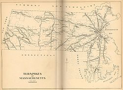
. A small, 1.5 miles (2.4 km) stretch of the turnpike remains in Chelmsford, now known as "Turnpike Road." An extremely small section near North Chelmsford remains in a residential section of town, called "Old Middlesex Turnpike." From there, maps show a route along what appears to be North Road and Princeton Street into what is now North Chelmsford's Vinal Square, then Tyngsboro Road into Tyngsboro, and north to Nashua. It was about 26 miles (41.8 km) in length, with 4 toll gates along the way.
As was the practice of that time, the road was as straight as possible, and thus missed the advantages of passing through economic centers along the way. As its route closely paralleled that of the Middlesex Canal
Middlesex Canal
The Middlesex Canal was a 27-mile barge canal connecting the Merrimack River with the port of Boston. When operational it was 30 feet wide, and 3 feet deep, with 20 locks, each 80 feet long and between 10 and 11 feet wide...
, and later the railroad, it suffered stiff competition for both freight and passenger traffic. The road was thus never particularly profitable. Its charter was repealed in 1841, and it became a free road in 1846. Some sections became disused at some point - there is a section in Billerica at the Concord River
Concord River
The Concord River is a tributary of the Merrimack River in eastern Massachusetts in the United States. The river drains a small rural and suburban region northwest of Boston. One of the most famous small rivers in U.S...
that is discontinuous, and a large section missing between Billerica (River Street) and Chelmsford (Mill Road).
U.S. Route 3
U.S. Route 3
U.S. Route 3 is a north–south United States highway that runs from its southern terminus in Cambridge, Massachusetts through New Hampshire to its terminus near Third Connecticut Lake at the Canadian border, where the road continues north as Quebec Route 257.In New Hampshire parts of US 3 are...
, the expressway largely built in the 1950s from Burlington to Tyngsboro, follows the path of the Middlesex Turnpike very closely.
Improvement Project
The MassDOT is planning to upgrade the Middlesex Turnpike in cooperation with the Towns of Burlington, Bedford and Billerica. Phase 2 which begins in Burlington at Route 62 and Middlesex Turnpike and stretches into Bedford just north of Crosby Drive. Phase 1 was Completed in 2007. Total cost of Phase 2 is expected to be $13 Million+. Construction on Phase 2 is expected to begin in July 2010. The contractor for Phase 2 is Newport Construction Corporation of Nashua Hew Hampshire.Billerica is planning that phase 3 become a multi-modal corridor -- a green road plus 3 modes, including transit, bike lanes and sidewalks for pedestrians.