
Bassetlaw
Encyclopedia
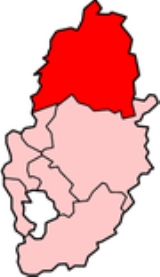
Bassetlaw is the northernmost district
of Nottinghamshire
, England
, with a population according to the 2001 UK census
of 107,713. The borough is predominantly rural, with two towns: Worksop
, site of the borough offices, and Retford
. The district was formed on April 1, 1974 by the merger of the boroughs of Worksop
and East Retford and most of Worksop Rural District
and most of East Retford Rural District
. It is named for the historic Bassetlaw
wapentake of Nottinghamshire.
Askham
, Babworth
, Beckingham
, Bevercotes
, Bircotes
, Blyth
, Bole
, Bothamsall
, Carburton
, Carlton-in-Lindrick, Clarborough
, Clayworth
, Cotes
, Cottam
, Cuckney
, Darlton
, Dunham on Trent, East Drayton
, East Markham
, Eaton
, Elkesley
, Everton
, Gamston
, Gringley-on-the-Hill
, Grove
, Harworth
, Hayton
, Headon, Langold
, Lound, Low Marnham, Markham Moor
, Marnham, Mattersey
, Milton
, Misson
, Misterton
, Normanton-on-Trent, North Leverton-with-Habblesthorpe, North Wheatley
, Oldcotes
, Ragnall
, Rampton
, Ranby
, Ranskill
, Rhodesia
, Rockley, Saundby
, Scrooby
, Shireoaks
, South Leverton
, Sutton cum Lound
, Sturton le Steeple
, Torworth
, Treswell, Tuxford
, Walkeringham
, West Drayton, West Markham, West Stockwith
, Woodbeck
.
, with Labour
gaining control. The party held power until 1976, with no party in overall control until 1979. Labour
gained control again in 1979 and held overall control until 2004. From 2004 to 2006 no party had overall control, But in 2006 the Conservatives
gained control of the council. John Mann
, of the Labour party, has been MP of Bassetlaw
since 2001.
. Bassetlaw is a safe seat
for the Labour Party
, with them having held it since 1935. In fact, Labour first won the seat in the 1929 general election
. However its Member of Parliament
Malcolm MacDonald
was one of the few Labour MPs to join his father Ramsay MacDonald
's National Government
. MacDonald held the seat as a National Labour candidate in the 1931 election
, but was defeated at the next election in 1935 by Labour's Frederick Bellenger
.
MPs
:
, Texas
, USA Garbsen
, Germany
Aurillac
, France
Non-metropolitan district
Non-metropolitan districts, or colloquially shire districts, are a type of local government district in England. As created, they are sub-divisions of non-metropolitan counties in a so-called "two-tier" arrangement...
of Nottinghamshire
Nottinghamshire
Nottinghamshire is a county in the East Midlands of England, bordering South Yorkshire to the north-west, Lincolnshire to the east, Leicestershire to the south, and Derbyshire to the west...
, England
England
England is a country that is part of the United Kingdom. It shares land borders with Scotland to the north and Wales to the west; the Irish Sea is to the north west, the Celtic Sea to the south west, with the North Sea to the east and the English Channel to the south separating it from continental...
, with a population according to the 2001 UK census
United Kingdom Census 2001
A nationwide census, known as Census 2001, was conducted in the United Kingdom on Sunday, 29 April 2001. This was the 20th UK Census and recorded a resident population of 58,789,194....
of 107,713. The borough is predominantly rural, with two towns: Worksop
Worksop
Worksop is the largest town in the Bassetlaw district of Nottinghamshire, England on the River Ryton at the northern edge of Sherwood Forest. It is about east-south-east of the City of Sheffield and its population is estimated to be 39,800...
, site of the borough offices, and Retford
Retford
Retford is a market town in Nottinghamshire in the East Midlands of England, located 31 miles from the city of Nottingham, and 23 miles west of Lincoln, in the district of Bassetlaw. The town is situated in a valley with the River Idle and the Chesterfield Canal running through the centre of the...
. The district was formed on April 1, 1974 by the merger of the boroughs of Worksop
Worksop
Worksop is the largest town in the Bassetlaw district of Nottinghamshire, England on the River Ryton at the northern edge of Sherwood Forest. It is about east-south-east of the City of Sheffield and its population is estimated to be 39,800...
and East Retford and most of Worksop Rural District
Worksop Rural District
Worksop was a Rural District in Nottinghamshire, England.It originated as Worksop Rural Sanitary District in 1872...
and most of East Retford Rural District
East Retford Rural District
East Retford was a rural district in Nottinghamshire, England from 1894 to 1974.It was formed under the Local Government Act 1894 from East Retford rural sanitary district...
. It is named for the historic Bassetlaw
Bassetlaw (wapentake)
Bassetlaw was a wapentake in the English county of Nottinghamshire. The wapentake covered an area in the north of the county, roughly equivalent to the modern Bassetlaw local government district. The wapentake was divided into the divisions of Hatfield, North Clay and South Clay.The place name...
wapentake of Nottinghamshire.
Settlements
The two main settlements in Bassetlaw are Worksop and Retford. Smaller settlements include:Askham
Askham, Nottinghamshire
Askham is a village and civil parish in the Bassetlaw district of Nottinghamshire, England, about six miles south-east of East Retford. According to the 2001 census it had a population of 183.St. Nicholas' Church, Askham is Norman, restored in 1906-07....
, Babworth
Babworth
Babworth is a village and civil parish in the Bassetlaw district of Nottinghamshire, England, about 1½ miles west of Retford. According to the 2001 census the parish had a population of 1,329...
, Beckingham
Beckingham, Nottinghamshire
Beckingham is a village and civil parish in the Bassetlaw district of Nottinghamshire, England, about three miles west of Gainsborough, Lincolnshire. According to the 2001 census it had a population of 1,168....
, Bevercotes
Bevercotes
Bevercotes is a hamlet and civil parish in the Bassetlaw district of Nottinghamshire, England, about six miles south of East Retford and five miles north-east of Ollerton. According to the 2001 census it had a population of 28....
, Bircotes
Bircotes
Bircotes is a mining town in the Bassetlaw district of Nottinghamshire, on the border with the metropolitan borough of Doncaster . It is located at , and forms the civil parish of Harworth and Bircotes with its neighbour Harworth. The parish has a population of around 8,000 people. The nearest...
, Blyth
Blyth, Nottinghamshire
Blyth is a village in the Bassetlaw district of the county of Nottinghamshire, in the East Midlands, north west of East Retford, on the River Ryton.-Geography:...
, Bole
Bole, Nottinghamshire
Bole is a village and civil parish in the Bassetlaw district of Nottinghamshire, England. It is close by the River Trent, on the eastern side of which is Gainsborough in Lincolnshire. According to the 2001 census it had a population of 140...
, Bothamsall
Bothamsall
Bothamsall is a village and civil parish in the Bassetlaw district of Nottinghamshire, England.According to the United Kingdom Census 2001 it had a population of 185.- History & Amenities :...
, Carburton
Carburton
Carburton is a village within the Bassetlaw district of Nottinghamshire, England. It is primarily rural and residential. The church of St Giles is an unusual shape and dates back to the early 12th century, parish records date back to the 1530s...
, Carlton-in-Lindrick, Clarborough
Clarborough
Clarborough is a village in Nottinghamshire, England. The civil parish of Clarborough and Welham had a population of 1,111 in the 2001 census. It is located 3 miles north-east of Retford. The parish church of St John the Baptist is of 13th century date, restored in 1874...
, Clayworth
Clayworth
Clayworth is a village and civil parish in Nottinghamshire, England. At the time of the 2001 census it had a population of 319. It is located 6 miles north-east of Retford....
, Cotes
Cotes
-Surname:* Francis Cotes , an English painter* George Cotes , an English Catholic bishop* Merton Russell-Cotes , FRGS, a Mayor of Bournemouth, England* Roger Cotes , an English mathematician, colleague of Isaac Newton...
, Cottam
Cottam
A cottam, as confirmed by the Oxford University's History Department is derived from the word "cottage". It means a collection of cottages at the end of a lane, smaller than a hamlet.Cottam could be*Cottam, East Riding of Yorkshire, England...
, Cuckney
Cuckney
Cuckney is a small village in the Bassetlaw district of Nottinghamshire, between Worksop and Market Warsop.The A60 road connects Market Warsop and Cuckney via Cuckney Hill.-History:...
, Darlton
Darlton
Darlton is a small village and civil parish in Nottinghamshire, England. It is on the A57 road about north-east of Tuxford.The Church of England parish church of St Giles is 12th century and is in the Transitional style. In 1855 it was heavily restored by the architect T.C...
, Dunham on Trent, East Drayton
East Drayton
East Drayton is a village in Nottinghamshire, England. According to the 2001 census it had a population of 212. It is located 3 miles west of Dunham-on-Trent.The parish church of St Peter and St Paul is 13th or 14th century in date....
, East Markham
East Markham
East Markham, historically also known as Great Markham, is a small village near Tuxford, Nottinghamshire. It lies about 8 km south of Retford...
, Eaton
Eaton, Nottinghamshire
Eaton is a village in Nottinghamshire, England. According to the 2001 census it had a population of 105. It is located 2 miles south of Retford, on the A638 road.The parish church was completely rebuilt in 1860 in Decorated style....
, Elkesley
Elkesley
Elkesley is a village in Nottinghamshire, England. According to the 2001 census it had a population of 805. It is located 6 miles south of Retford.The parish church of St Giles was built c. 1300 in Decorated style, and was partially reconstructed in 1845...
, Everton
Everton, Nottinghamshire
Everton is a village and civil parish in Nottinghamshire, England. Located on the A631 between Gainsborough and Bawtry, it is part of Bassetlaw district.The village is recorded in the Domesday Book of 1086-7 as Evretone....
, Gamston
Gamston, Bassetlaw
Gamston is a village four miles south of Retford in the county of Nottinghamshire. The village lies on the A638 road between Retford and the Markham Moor junction with the A1 and the A57 roads...
, Gringley-on-the-Hill
Gringley-on-the-Hill
Gringley-on-the-Hill, Nottinghamshire, is an English village and parish. It is on the highest part of the road from Bawtry to Gainsborough, six miles east-southeast of the former, and the same distance west by north of the latter town.- Location :...
, Grove
Grove, Nottinghamshire
Grove is a small village, lying about 2 miles south-west of Retford, Nottinghamshire. In fact, the parklands of Grove Hall separate it from Retford town, and a set of gates for Grove Hall can be found near the London Road, the A638....
, Harworth
Harworth
Harworth is a small town in the county of Nottinghamshire, in the Midlands of England in Bassetlaw district. It is approximately eight miles north of Worksop...
, Hayton
Hayton, Nottinghamshire
Hayton is a village in Nottinghamshire, England. It is located 4 miles north-east of Retford. According to the 2001 census it had a population of 386.The parish church of St Peter is Norman, with 14th century windows....
, Headon, Langold
Langold
Langold is a village in Bassetlaw, North Nottinghamshire. It was built to provide housing for the miners of Firbeck Colliery between 1923 and 1927, and Langold Lakes Country Park is situated on the south-western edge of the village.-History:...
, Lound, Low Marnham, Markham Moor
Markham Moor
Markham Moor is a village which lies five miles south of the town of Retford in the county of Nottinghamshire. Markham Moor lies on the junction between the A1, A638 and A57 roads...
, Marnham, Mattersey
Mattersey
Mattersey is a village in Nottinghamshire, England. It is located 8 miles north of Retford and sits on the border of Nottinghamshire and South Yorkshire, being just under 14 miles from Doncaster. According to the 2001 census it had a population of 779....
, Milton
Milton, Nottinghamshire
Milton, Nottinghamshire is a village/hamlet in Nottinghamshire. It is part of East Markham civil parish, a short distance northwest of East Markham and southwest of Sibthorpe.-Mausoleum:...
, Misson
Misson, Nottinghamshire
Misson is a village in Nottinghamshire, England. It is located 12 miles north of Retford, and not directly accessible from the rest of Nottinghamshire. Misson Springs, which lie north of the village itself, is the northenmost place within the county...
, Misterton
Misterton, Nottinghamshire
Misterton is a village and civil parish in the Bassetlaw district of Nottinghamshire, England.-Geography:Misterton is located in the far north-east of both Bassetlaw and Nottinghamshire between Walkeringham to the South and Haxey to the North. The East of the village is bordered by the River...
, Normanton-on-Trent, North Leverton-with-Habblesthorpe, North Wheatley
North Wheatley
North Wheatley is a village and civil parish in Nottinghamshire, England. At the time of the 2001 census it had a population of 489. It is located 6 miles north-east of Retford. The village has a number of 17th century brick houses. The Old Hall on Low Street/Church Hill is dated 1673, with the...
, Oldcotes
Oldcotes
Oldcotes is a village in Nottinghamshire, England. It is in the civil parish of Styrrup with Oldcotes. The village is centred around the crossroads of the A60 and A634 roads, five miles south east of Maltby.The history of the village is long and varied...
, Ragnall
Ragnall
Ragnall is a village and former civil parish in Nottinghamshire, England. At the time of the 2001 census it had a population of 102. It is located on the A57 road one mile west of the River Trent. The parish church of St Leonard was extensively rebuilt in 1864-67...
, Rampton
Rampton, Nottinghamshire
Rampton is a village and civil parish in Nottinghamshire, England. At the time of the 2001 census it had a population of 1,269. Its name came from Anglo-Saxon Ramm-tūn = "ram farmstead". It is located in the Trent valley north of Nottingham, in the Bassetlaw district 8 miles east of Retford...
, Ranby
Ranby, Nottinghamshire
Ranby is a small village in the north of Nottinghamshire, next to the Chesterfield Canal and adjacent to the A1. It is known for its two schools, the prep school Ranby House and the primary school Ranby Primary School, and the nearby church All Saints Babworth.Ranby Prison is located on the A620 to...
, Ranskill
Ranskill
Ranskill is a village and civil parish in the Bassetlaw district of Nottinghamshire with its nearest town being Retford approximately 5 miles south...
, Rhodesia
Rhodesia, Nottinghamshire
Rhodesia is a village and parish located in the county of Nottinghamshire, in central England. The village lies 20 miles from Sheffield and is a part of the Sheffield city region. It was named after the erstwhile Chairman of the nearby Shireoaks Colliery, G. Preston Rhodes.Rhodesia is a small...
, Rockley, Saundby
Saundby
Saundby is a village in Nottinghamshire, England two miles west of Gainsborough and lies within the civil parish of Beckingham cum Saundby. The parish is bordered on one side by the River Trent. The village Church of St Martin was extensively restored in 1885....
, Scrooby
Scrooby
Scrooby is a small village, on the River Ryton and near Bawtry, in the northern part of the English county of Nottinghamshire. At the time of the 2001 census it had a population of 329. Until 1766, it was on the Great North Road so became a stopping-off point for numerous important figures...
, Shireoaks
Shireoaks
Shireoaks is a former pit village in Nottinghamshire, located between Worksop and Thorpe Salvin.The Chesterfield Canal and River Ryton both run through the village...
, South Leverton
South Leverton
South Leverton is a village and civil parish in Bassetlaw, north Nottinghamshire, England, four miles from Retford. According to the 2001 census it has a population of 478.-Geography:...
, Sutton cum Lound
Sutton cum Lound
Sutton-Cum-Lound is a village located in Bassetlaw, North Nottinghamshire. It is located 3 miles from Retford. According to the 2001 census it has a population of 687. The parish church of St Bartholomew is Norman, rebuilt in the Perpendicular style, with "unbridled curvilinear tracery" in the...
, Sturton le Steeple
Sturton le Steeple
Sturton le Steeple is a village in Nottinghamshire, England. It is located 6 miles east of Retford. According to the 2001 census it had a population of 497.The parish church of St Peter and St Paul has a 14th century tower with 12 pinnacles...
, Torworth
Torworth
Torworth pronounced ‘Tor-erth’ , is a small village on the A638 or 'Great North Road' in North Nottinghamshire. According to the 2001 census it had a population of 264...
, Treswell, Tuxford
Tuxford
-Geography:Tuxford is a village and a civil parish on the southern edge of the Bassetlaw district of Nottinghamshire, England. It may also be considered a small town as it was historically a market town. Nearby larger towns are Retford and Newark-on-Trent. From Harvest Cottage, near the ECML, the...
, Walkeringham
Walkeringham
Walkeringham is a village and civil parish in Nottinghamshire, England. According to the 2001 census it had a population of 908. The parish church of St Mary Magdalen is 13th century. It has one public house called The Fox and Hounds, and a post office. It also has a former station house and a...
, West Drayton, West Markham, West Stockwith
West Stockwith
West Stockwith is a village within the Bassetlaw district of Nottinghamshire, England.East Stockwith is a settlement close by, but within the county boundaries of Lincolnshire.-Etymology:...
, Woodbeck
Civil parishes
There are 68 parishes in Bassetlaw. The two main settlements of Retford and Worksop are the only areas of the district that are unparishedUnparished area
In England, an unparished area is an area that is not covered by a civil parish. Most urbanised districts of England are either entirely or partly unparished. Many towns and some cities in otherwise rural districts are also unparished areas and therefore no longer have a town council or city...
.
Wards
Bassetlaw is split into 25 separate wards for elections.
|
|
Politics
The first elections to the council took place in 1973United Kingdom local elections, 1973
The first elections to the new local authorities established by the Local Government Act 1972 in England and Wales and the new Northern Ireland district councils created by the Local Government Act 1972 took place in 1973...
, with Labour
Labour Party (UK)
The Labour Party is a centre-left democratic socialist party in the United Kingdom. It surpassed the Liberal Party in general elections during the early 1920s, forming minority governments under Ramsay MacDonald in 1924 and 1929-1931. The party was in a wartime coalition from 1940 to 1945, after...
gaining control. The party held power until 1976, with no party in overall control until 1979. Labour
Labour Party (UK)
The Labour Party is a centre-left democratic socialist party in the United Kingdom. It surpassed the Liberal Party in general elections during the early 1920s, forming minority governments under Ramsay MacDonald in 1924 and 1929-1931. The party was in a wartime coalition from 1940 to 1945, after...
gained control again in 1979 and held overall control until 2004. From 2004 to 2006 no party had overall control, But in 2006 the Conservatives
Conservative Party (UK)
The Conservative Party, formally the Conservative and Unionist Party, is a centre-right political party in the United Kingdom that adheres to the philosophies of conservatism and British unionism. It is the largest political party in the UK, and is currently the largest single party in the House...
gained control of the council. John Mann
John Mann
John Mann may refer to:* John Mann , British actor* John Mann * John Mann , farmer and author from New Brunswick, Canada* John Mann , English cricketer...
, of the Labour party, has been MP of Bassetlaw
Bassetlaw (UK Parliament constituency)
Bassetlaw is a parliamentary constituency represented in the House of Commons of the Parliament of the United Kingdom. It elects one Member of Parliament by the first past the post system of election.-Boundaries:...
since 2001.
Parliamentary Constituency
The constituency was created in 1885 by the Redistribution of Seats ActRedistribution of Seats Act 1885
The Redistribution of Seats Act 1885 was an Act of the Parliament of the United Kingdom. It was a piece of electoral reform legislation that redistributed the seats in the House of Commons, introducing the concept of equally populated constituencies, in an attempt to equalise representation across...
. Bassetlaw is a safe seat
Safe seat
A safe seat is a seat in a legislative body which is regarded as fully secured, either by a certain political party, the incumbent representative personally or a combination of both...
for the Labour Party
Labour Party (UK)
The Labour Party is a centre-left democratic socialist party in the United Kingdom. It surpassed the Liberal Party in general elections during the early 1920s, forming minority governments under Ramsay MacDonald in 1924 and 1929-1931. The party was in a wartime coalition from 1940 to 1945, after...
, with them having held it since 1935. In fact, Labour first won the seat in the 1929 general election
United Kingdom general election, 1929
-Seats summary:-References:*F. W. S. Craig, British Electoral Facts: 1832-1987*-External links:***...
. However its Member of Parliament
Member of Parliament
A Member of Parliament is a representative of the voters to a :parliament. In many countries with bicameral parliaments, the term applies specifically to members of the lower house, as upper houses often have a different title, such as senate, and thus also have different titles for its members,...
Malcolm MacDonald
Malcolm MacDonald
Malcolm John MacDonald OM, PC was a British politician and diplomat.-Background:MacDonald was the son of Prime Minister Ramsay MacDonald and Margaret MacDonald. Like his father he was born in Lossiemouth, Moray...
was one of the few Labour MPs to join his father Ramsay MacDonald
Ramsay MacDonald
James Ramsay MacDonald, PC, FRS was a British politician who was the first ever Labour Prime Minister, leading a minority government for two terms....
's National Government
UK National Government
In the United Kingdom the term National Government is an abstract concept referring to a coalition of some or all major political parties. In a historical sense it usually refers primarily to the governments of Ramsay MacDonald, Stanley Baldwin and Neville Chamberlain which held office from 1931...
. MacDonald held the seat as a National Labour candidate in the 1931 election
United Kingdom general election, 1931
The United Kingdom general election on Tuesday 27 October 1931 was the last in the United Kingdom not held on a Thursday. It was also the last election, and the only one under universal suffrage, where one party received an absolute majority of the votes cast.The 1931 general election was the...
, but was defeated at the next election in 1935 by Labour's Frederick Bellenger
Frederick Bellenger
Captain Frederick John Bellenger was a British surveyor, journalist, soldier and Labour Party politician.-Soldier:...
.
MPs
Member of Parliament
A Member of Parliament is a representative of the voters to a :parliament. In many countries with bicameral parliaments, the term applies specifically to members of the lower house, as upper houses often have a different title, such as senate, and thus also have different titles for its members,...
:
- 1935 Frederick BellengerFrederick BellengerCaptain Frederick John Bellenger was a British surveyor, journalist, soldier and Labour Party politician.-Soldier:...
(Labour) - 1968 Joe Ashton (Labour)
- 2001 John Mann (Labour)
Council Elections
Bassetlaw District Council was founded in 1973 with Labour first gaining control. From 1976 to 1979, no party had overall control, until the 1979 local elections in which Labour gained control. Labour controlled the council for 25 years, until once again no party had overall control. In 2006, the Conservatives gained control of the council, and held control until 2010 when a series of by-election defeats caused them to lose their majority. In 2011 Labour gained control of the council for the first time in seven years. One third of the council is elected each year, followed by one year without election.Council political makeup
| Year | Labour Labour Party (UK) The Labour Party is a centre-left democratic socialist party in the United Kingdom. It surpassed the Liberal Party in general elections during the early 1920s, forming minority governments under Ramsay MacDonald in 1924 and 1929-1931. The party was in a wartime coalition from 1940 to 1945, after... | Conservative Conservative Party (UK) The Conservative Party, formally the Conservative and Unionist Party, is a centre-right political party in the United Kingdom that adheres to the philosophies of conservatism and British unionism. It is the largest political party in the UK, and is currently the largest single party in the House... | Independent Independent (politician) In politics, an independent or non-party politician is an individual not affiliated to any political party. Independents may hold a centrist viewpoint between those of major political parties, a viewpoint more extreme than any major party, or they may have a viewpoint based on issues that they do... | Liberal Democrats |
|---|---|---|---|---|
| 2011 election Bassetlaw Council election, 2011 The 2011 Bassetlaw council election took place on 5 May 2011 to elect members of Bassetlaw District Council in Nottinghamshire, England as part of the 2011 United Kingdom local elections. One third of the council was up for election... |
27 | 18 | 3 | 0 |
| 2010 election Bassetlaw Council election, 2010 The 2010 Bassetlaw council election took place on 6 May 2010 to elect members of Bassetlaw District Council in Nottinghamshire, England as part of the 2010 United Kingdom local elections... |
20 | 25 | 3 | 0 |
| 2008 election Bassetlaw Council election, 2008 The 2008 Bassetlaw Council election took place on 1 May 2008 to elect members of Bassetlaw District Council in Nottinghamshire, England. One third of the council was up for election.After the election, the composition of the council was:*Conservative 30... |
16 | 30 | 2 | 0 |
| 2007 election Bassetlaw Council election, 2007 The 2007 Bassetlaw Council election took place on 3 May 2007 to elect members of Bassetlaw District Council in Nottinghamshire, England. One third of the council was up for election.-Election result:-Blyth:-Carlton:-East Markham:... |
16 | 27 | 5 | 0 |
| 2006 election Bassetlaw Council election, 2006 The 2006 Bassetlaw Council election took place on 4 May 2006 to elect members of Bassetlaw District Council in Nottinghamshire, England. One third of the council was up for election.-Election result:-Carlton:-East Retford East:... |
14 | 28 | 5 | 1 |
Population
| Population of Bassetlaw (1801 - 2001) | |||||||
|---|---|---|---|---|---|---|---|
| Year | Population | Year | Population | Year | Population | ||
| 1801 | 23,867 | 1871 | 41,550 | 1941 | 85,182 | ||
| 1811 | 25,813 | 1881 | 43,735 | 1951 | 101,590 | ||
| 1821 | 30,148 | 1891 | 45,203 | 1961 | 99,221 | ||
| 1831 | 32,950 | 1901 | 50,796 | 1971 | 96,918 | ||
| 1841 | 34,961 | 1911 | 57,084 | 1981 | 101,119 | ||
| 1851 | 37,180 | 1921 | 63,854 | 1991 | 105,354 | ||
| 1861 | 39,365 | 1931 | 71,427 | 2001 | 107,701 | ||
| Pre-1974 statistics were gathered from local government areas that now comprise Bassetlaw. Source: Great Britain Historical GIS Great Britain Historical GIS The Great Britain Historical GIS , is a spatially-enabled database that documents and visualises the changing human geography of the British Isles, although is primarily focussed on the subdivisions of the United Kingdom mainly over the 200 years since the first census in 1801... . |
|||||||
Religion
| Religion | Percent |
|---|---|
| Christian Christian A Christian is a person who adheres to Christianity, an Abrahamic, monotheistic religion based on the life and teachings of Jesus of Nazareth as recorded in the Canonical gospels and the letters of the New Testament... |
81.53% |
| Buddhist | 0.09% |
| Hindu Hindu Hindu refers to an identity associated with the philosophical, religious and cultural systems that are indigenous to the Indian subcontinent. As used in the Constitution of India, the word "Hindu" is also attributed to all persons professing any Indian religion... |
0.13% |
| Jewish | 0.05% |
| Muslim Muslim A Muslim, also spelled Moslem, is an adherent of Islam, a monotheistic, Abrahamic religion based on the Quran, which Muslims consider the verbatim word of God as revealed to prophet Muhammad. "Muslim" is the Arabic term for "submitter" .Muslims believe that God is one and incomparable... |
0.33% |
| Sikh Sikh A Sikh is a follower of Sikhism. It primarily originated in the 15th century in the Punjab region of South Asia. The term "Sikh" has its origin in Sanskrit term शिष्य , meaning "disciple, student" or शिक्ष , meaning "instruction"... |
0.07% |
| No religion | 9.99% |
Town twinning
Farmers BranchFarmers Branch, Texas
Farmers Branch is a city in Dallas County, Texas, United States. It is both an inner-ring suburb of Dallas and is part of the Dallas–Fort Worth Metroplex. The population was 27,508 at the 2000 census. A July 1, 2008 U.S...
, Texas
Texas
Texas is the second largest U.S. state by both area and population, and the largest state by area in the contiguous United States.The name, based on the Caddo word "Tejas" meaning "friends" or "allies", was applied by the Spanish to the Caddo themselves and to the region of their settlement in...
, USA Garbsen
Garbsen
Garbsen is a town in the district of Hanover, in Lower Saxony, Germany. It is situated on the river Leine, approx. 11 km northwest of Hanover.-Division of the town:The town consists of 13 districts:* Altgarbsen* Auf der Horst* Berenbostel...
, Germany
Germany
Germany , officially the Federal Republic of Germany , is a federal parliamentary republic in Europe. The country consists of 16 states while the capital and largest city is Berlin. Germany covers an area of 357,021 km2 and has a largely temperate seasonal climate...
Aurillac
Aurillac
Aurillac is a commune in the Auvergne region in south-central France, capital of the Cantal department.Aurillac's inhabitants are called Aurillacois, and are also Cantaliens or Cantalous in Occitan....
, France
France
The French Republic , The French Republic , The French Republic , (commonly known as France , is a unitary semi-presidential republic in Western Europe with several overseas territories and islands located on other continents and in the Indian, Pacific, and Atlantic oceans. Metropolitan France...