
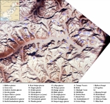
Baltoro Muztagh
Encyclopedia
The Baltoro Muztagh is a subrange of the Karakoram
mountain range
, in Baltistan
region of the Gilgit-Baltistan province in northern Pakistan
; and in Xinjiang
, China
. The crest of the range forms part of the Pakistan-China border.
The range is home to K2
(8611 metres (28,251.3 ft)), the second highest mountain in the world, and to three other Eight-thousander peaks
. They are located on the north and east sides of the Baltoro Glacier
.
.
(This is a common criterion for peaks of this stature to be independent.)
Karakoram
The Karakoram, or Karakorum , is a large mountain range spanning the borders between Pakistan, India and China, located in the regions of Gilgit-Baltistan , Ladakh , and Xinjiang region,...
mountain range
Mountain range
A mountain range is a single, large mass consisting of a succession of mountains or narrowly spaced mountain ridges, with or without peaks, closely related in position, direction, formation, and age; a component part of a mountain system or of a mountain chain...
, in Baltistan
Baltistan
Baltistan , also known as بلتیول བལིུལ་ in the Balti language, is a region in northern Pakistan which forms Gilgit-Baltistan, bordering the Xinjiang Autonomous Region of China. In addition, a part of Baltistan also falls into Jammu and Kashmir of India. It is situated in the Karakoram mountains...
region of the Gilgit-Baltistan province in northern Pakistan
Pakistan
Pakistan , officially the Islamic Republic of Pakistan is a sovereign state in South Asia. It has a coastline along the Arabian Sea and the Gulf of Oman in the south and is bordered by Afghanistan and Iran in the west, India in the east and China in the far northeast. In the north, Tajikistan...
; and in Xinjiang
Xinjiang
Xinjiang is an autonomous region of the People's Republic of China. It is the largest Chinese administrative division and spans over 1.6 million km2...
, China
China
Chinese civilization may refer to:* China for more general discussion of the country.* Chinese culture* Greater China, the transnational community of ethnic Chinese.* History of China* Sinosphere, the area historically affected by Chinese culture...
. The crest of the range forms part of the Pakistan-China border.
The range is home to K2
K2
K2 is the second-highest mountain on Earth, after Mount Everest...
(8611 metres (28,251.3 ft)), the second highest mountain in the world, and to three other Eight-thousander peaks
Eight-thousander
The eight-thousanders are the fourteen independent mountains on Earth that are more than high above sea level. They are all located in the Himalayan and Karakoram mountain ranges in Asia....
. They are located on the north and east sides of the Baltoro Glacier
Baltoro Glacier
The Baltoro Glacier, at 62 kilometers long, is one of the longest glaciers outside the polar regions. It is located in Baltistan, in the Gilgit-Baltistan region of Pakistan, and runs through part of the Karakoram mountain range. The Baltoro Muztagh lies to the north and east of the glacier, while...
.
Selected peaks of the Baltoro Muztagh
The following is a table of the peaks in the Baltoro Muztagh which are over 7200 metres (23,622 ft) in elevation and have over 500 metres (1,640.4 ft) of topographic prominenceTopographic prominence
In topography, prominence, also known as autonomous height, relative height, shoulder drop , or prime factor , categorizes the height of the mountain's or hill's summit by the elevation between it and the lowest contour line encircling it and no higher summit...
.
(This is a common criterion for peaks of this stature to be independent.)
| Mountain | Height (m) | Height (ft) | Coordinates | Prominence (m) | Parent mountain | First ascent | Ascents (attempts) |
|---|---|---|---|---|---|---|---|
| K2 K2 K2 is the second-highest mountain on Earth, after Mount Everest... |
8,611 | 28,251 | 35°52′57"N 76°30′48"E | 4,017 | Mount Everest Mount Everest Mount Everest is the world's highest mountain, with a peak at above sea level. It is located in the Mahalangur section of the Himalayas. The international boundary runs across the precise summit point... |
1954 | 45 (44) |
| Gasherbrum I Gasherbrum I Gasherbrum I , also known as Hidden Peak or K5, is the 11th highest peak on Earth, located on the Pakistan-China border in Gilgit-Baltistan region of Pakistan and Xinjiang region of China. Gasherbrum I is part of the Gasherbrum massif, located in the Karakoram region of the Himalaya... |
8,080 | 26,509 | 35°43′27"N 76°41′44"E | 2,155 | K2 K2 K2 is the second-highest mountain on Earth, after Mount Everest... |
1958 | 31 (16) |
| Broad Peak Broad Peak Broad Peak , is the 12th highest mountain on Earth, with an elevation of 8,051 meters . The literal translation of "Broad Peak" to Faichan Kangri is not accepted among the Balti people.- Geography :... |
8,051 | 26,414 | 35°48′38"N 76°34′05"E | 1,701 | Gasherbrum I Gasherbrum I Gasherbrum I , also known as Hidden Peak or K5, is the 11th highest peak on Earth, located on the Pakistan-China border in Gilgit-Baltistan region of Pakistan and Xinjiang region of China. Gasherbrum I is part of the Gasherbrum massif, located in the Karakoram region of the Himalaya... |
1957 | 39 (19) |
| Gasherbrum II Gasherbrum II Gasherbrum II , also known as K4, is the 13th highest mountain on Earth, located on the border of Gilgit-Baltistan province, Pakistan and Xinjiang, China... |
8,034 | 26,362 | 35°45′27"N 76°39′11"E | 1,523 | Gasherbrum I Gasherbrum I Gasherbrum I , also known as Hidden Peak or K5, is the 11th highest peak on Earth, located on the Pakistan-China border in Gilgit-Baltistan region of Pakistan and Xinjiang region of China. Gasherbrum I is part of the Gasherbrum massif, located in the Karakoram region of the Himalaya... |
1956 | 54 (12) |
| Gasherbrum III Gasherbrum III Gasherbrum III is a summit in the Gasherbrum massif of the Baltoro Muztagh, a subrange of the Karakoram on the border between Northern Areas of Pakistan and Xinjiang, China, in the region of Baltistan... |
7,946 | 26,070 | 35°45′34"N 76°38′31"E | 355 | Gasherbrum II Gasherbrum II Gasherbrum II , also known as K4, is the 13th highest mountain on Earth, located on the border of Gilgit-Baltistan province, Pakistan and Xinjiang, China... |
1975 | 2 (2) |
| Gasherbrum IV Gasherbrum IV Gasherbrum IV is the 17th highest mountain on Earth and the 6th highest in Pakistan. It is one of the peaks in the Gasherbrum massif.The Gasherbrums are a remote group of peaks located at the northeastern end of the Baltoro Glacier in the Karakoram range of the Himalaya. The massif contains three... |
7,932 | 26,024 | 35°45′33"N 76°36′57"E | 725 | Gasherbrum III Gasherbrum III Gasherbrum III is a summit in the Gasherbrum massif of the Baltoro Muztagh, a subrange of the Karakoram on the border between Northern Areas of Pakistan and Xinjiang, China, in the region of Baltistan... |
1958 | 4 (11) |
| Skyang Kangri Skyang Kangri Skyang Kangri, or Staircase Peak, is a high peak of the Baltoro Muztagh, a subrange of the Karakoram range. It lies on the Pakistan-China border, about 7 km northeast of K2, the world's second-highest mountain... |
7,545 | 24,754 | 35°55′35"N 76°34′03"E | 1,060 | K2 K2 K2 is the second-highest mountain on Earth, after Mount Everest... |
1976 | 1 (2) |
| Sia Kangri Sia Kangri Sia Kangri is a mountain in the Baltoro Muztagh in the Karakoram. Its summit is on the Tibet and Pakistan border. It is the 63rd highest mountain in the world, and the 25th highest in Pakistan. The peak is on the watershed between the Indus River basin and the Tarim Basin... |
7,422 | 24,350 | 35°39′48"N 76°45′45"E | 640 | Gasherbrum I Gasherbrum I Gasherbrum I , also known as Hidden Peak or K5, is the 11th highest peak on Earth, located on the Pakistan-China border in Gilgit-Baltistan region of Pakistan and Xinjiang region of China. Gasherbrum I is part of the Gasherbrum massif, located in the Karakoram region of the Himalaya... |
1934 | 6 (0) |
| Skil Brum Skil Brum Skil Brum, or Skilbrum, is a mountain in the Karakoram range in Northern Areas of Pakistan, approximately 9 km west-southwest of K2. It lies on the western side of the Godwin-Austen Glacier, roughly opposite Broad Peak.... |
7,410 | 24,311 | 35°51′03"N 76°25′45"E | 1,152 | K2 K2 K2 is the second-highest mountain on Earth, after Mount Everest... |
1957 | 2 (1) |
| Chongtar Kangri Chongtar Kangri Chongtar Kangri or Chongtar Peak is a mountain peak in the Xinjiang region of China. Chongtar is situated about 10 kilometers northwest of K2 and lies very near China's border with Pakistan.... |
7,315 | 23,999 | 35°54′46"N 76°25′47"E | 1,300 | Skil Brum Skil Brum Skil Brum, or Skilbrum, is a mountain in the Karakoram range in Northern Areas of Pakistan, approximately 9 km west-southwest of K2. It lies on the western side of the Godwin-Austen Glacier, roughly opposite Broad Peak.... |
1994 | 1 (1) |
| Muztagh Tower Muztagh Tower Muztagh Tower , is a mountain in the Baltoro Muztagh, part of the Karakoram range on the border of the Gilgit-Baltistan region of Pakistan and the Xinjiang Uygur region of China... |
7,276 | 23,871 | 35°49′38"N 76°21′39"E | 1,710 | Skil Brum Skil Brum Skil Brum, or Skilbrum, is a mountain in the Karakoram range in Northern Areas of Pakistan, approximately 9 km west-southwest of K2. It lies on the western side of the Godwin-Austen Glacier, roughly opposite Broad Peak.... |
1956 | 4 (2) |
Lower summits
There are a number of lower summits near the tongue of the Baltoro Glacier which are striking rock towers, and are famous for their aesthetic, difficult climbing. These include:- Great TrangoTrango TowersThe Trango Towers are a group of dramatic granite spires located on the north side of the Baltoro Glacier, in Baltistan, a district of the Gilgit-Baltistan region of Pakistan . They are part of the Baltoro Muztagh, a subrange of the Karakoram range. The Towers offer some of the largest cliffs and...
, 6,286 m - Trango (Nameless) TowerTrango TowersThe Trango Towers are a group of dramatic granite spires located on the north side of the Baltoro Glacier, in Baltistan, a district of the Gilgit-Baltistan region of Pakistan . They are part of the Baltoro Muztagh, a subrange of the Karakoram range. The Towers offer some of the largest cliffs and...
, 6,239 m - Uli BiahoUli BiahoUli Biaho is a peak near Trango Towers and Baltoro Glacier in the Northern Areas of Pakistan. It consists of two main peaks, Uli Biaho Tower ; and Uli Biaho Peak , which as of 2006 was unclimbed.Uli Biaho Tower was climbed alpine-style via the direct East Face by John Roskelley et al...
Tower, 6,109 m