

U.S. Route 25
Encyclopedia
U.S. Route 25 is a north–south United States highway that runs for 750 miles (1,207 km) from Brunswick, Georgia
to the Ohio
state line in Covington, Kentucky
.
/SR 25 in Brunswick
, US 25 goes northwest to Jesup
then northeast to Ludowicki
. It then stays at a general north route through the cities of Statesboro
, Millen
, Waynesboro
and finally Augusta
, where it crosses the Savannah River
into South Carolina
. The overall majority of the route is 4-lane.
from Augusta, Georgia
, US 25 goes north through downtown North Augusta
, connecting with I-20
just outside of town. US 25 goes northwesterly through the cities of Edgefield
, Greenwood
, and Greenville
; going due north at Travelers Rest
to the North Carolina
state line. Majority of the route is 4-lane, with various sections at expressway
grade.
From Interstate 85 southwest of Greenville, South Carolina
to Interstate 26 southeast of Hendersonville, North Carolina
, US 25, is Corridor W of the Appalachian Development Highway System
.
state line, US 25 becomes a freeway for 9 miles (14.5 km) before connecting with I-26
/US 74
near Flat Rock
. Splitting from I-26
/US 74
near Fletcher
, it goes north through Arden
, Biltmore Forest
, and downtown Asheville
, before reconnecting with I-26
near Woodfin
. At Weaverville
, US 25 and US 70 travel northwesterly together, through Marshall
and Hot Springs
into Tennessee
.
state line to Newport
, with US-70
, US-25 splits into US-25E
and US-25W. US-25E
goes north through the cities of Morristown
, Tazewell
, and Harrogate
, entering Kentucky
via the Cumberland Gap Tunnel
. US-25W goes west first to Knoxville
then parallels I-75
into Kentucky
.
from two locations, US 25E
goes through the cities of Middlesboro and Barbourville
, while US 25W continues its parallels I-75; both converge in Corbin
becoming US 25 again (though US 25E continues west as a connector road to I-75). US 25 parallels I-75 throughout Kentucky
, connecting the cities of London
, Berea
, Richmond
, Lexington
, and Dry Ridge
. US 25 ends in Covington
at the Ohio
state line over the Ohio River
; US 42
/US 127
continue into Cincinnati.
 US 25 originally extended northward into Ohio
and Michigan
before Interstate 75 between Detroit and Cincinnati and Interstate 94
between Detroit and Port Huron, Michigan
, made most of US 25 superfluous north of Cincinnati. In Michigan, M-25
continues as the designation of old US 25 between Port Austin
and Port Huron. Some old maps disagree on whether the east–west segment of what is now M-25 between Bay City
was US 25 or M-25; for that discussion see M-25
.
Relics of US 25 between Brownstown Township, Michigan
, (a suburb of Detroit) and Cygnet, Ohio
, include US 24, M-125
, and State Route 25.
US 25 in Michigan and Ohio was historically known as Dixie Highway
, and the road is still so named in some places. It may also be known as "County Road 25-A" through some parts of Ohio.
Until 1996 when the Cumberland Gap Tunnel
was opened to traffic, from Middlesboro, Kentucky, US 25E climbed the Cumberland Mountains
and along the historic Wilderness Road
, passed through the Cumberland Gap
into Virginia
then heading south to enter Tennessee
.
Old US 25 north of the intersection of US 11W in Tennessee crossed over Clinch Mountain, following a notorious route consisting of considerable elevation gain and many switchbacks, some of which were full hairpin turn
s.
Brunswick, Georgia
Brunswick is the major urban and economic center in southeastern Georgia in the United States. The municipality is located on a harbor near the Atlantic Ocean, approximately 30 miles north of Florida and 70 miles south of South Carolina. Brunswick is bordered on the east by the Atlantic...
to the Ohio
Ohio
Ohio is a Midwestern state in the United States. The 34th largest state by area in the U.S.,it is the 7th‑most populous with over 11.5 million residents, containing several major American cities and seven metropolitan areas with populations of 500,000 or more.The state's capital is Columbus...
state line in Covington, Kentucky
Covington, Kentucky
-Demographics:As of the census of 2000, there were 43,370 people, 18,257 households, and 10,132 families residing in the city. The population density was 3,301.3 people per square mile . There were 20,448 housing units at an average density of 1,556.5 per square mile...
.
Georgia
Starting at the intersection of US 17U.S. Route 17 in Georgia
U.S. Route 17 in Georgia runs north–south near the Atlantic Ocean, serving Brunswick and Savannah on its path from Florida at the St. Marys River to South Carolina at the Savannah River...
/SR 25 in Brunswick
Brunswick, Georgia
Brunswick is the major urban and economic center in southeastern Georgia in the United States. The municipality is located on a harbor near the Atlantic Ocean, approximately 30 miles north of Florida and 70 miles south of South Carolina. Brunswick is bordered on the east by the Atlantic...
, US 25 goes northwest to Jesup
Jesup, Georgia
Jesup is a city in Wayne County, Georgia, United States. The population was 9,279 at the 2000 census. The city is the county seat of Wayne County.-Geography:Jesup is located at ....
then northeast to Ludowicki
Ludowici, Georgia
Ludowici is a city in Long County, Georgia, United States. The population was 1,440 at the 2000 census. The city is the county seat of Long County...
. It then stays at a general north route through the cities of Statesboro
Statesboro, Georgia
Statesboro is a city in southeast Georgia, United States, and is the county seat and most populous city of Bulloch County. Statesboro has a population of 28,422 and the Statesboro, GA Micropolitan Statistical Area had a population of 70,217...
, Millen
Millen, Georgia
Millen is a city in Jenkins County, Georgia, United States. The population was 3,492 at the 2000 census, a decline of 8.3% since 1990, during a decade in which the state's population grew by 26.4%.The city, centered near the intersection of U.S...
, Waynesboro
Waynesboro, Georgia
Waynesboro is a city in Burke County, Georgia, United States. The population was 5,813 at the 2000 census. The city is the county seat of Burke County...
and finally Augusta
Augusta, Georgia
Augusta is a consolidated city in the U.S. state of Georgia, located along the Savannah River. As of the 2010 census, the Augusta–Richmond County population was 195,844 not counting the unconsolidated cities of Hephzibah and Blythe.Augusta is the principal city of the Augusta-Richmond County...
, where it crosses the Savannah River
Savannah River
The Savannah River is a major river in the southeastern United States, forming most of the border between the states of South Carolina and Georgia. Two tributaries of the Savannah, the Tugaloo River and the Chattooga River, form the northernmost part of the border...
into South Carolina
South Carolina
South Carolina is a state in the Deep South of the United States that borders Georgia to the south, North Carolina to the north, and the Atlantic Ocean to the east. Originally part of the Province of Carolina, the Province of South Carolina was one of the 13 colonies that declared independence...
. The overall majority of the route is 4-lane.
South Carolina
Entering South CarolinaSouth Carolina
South Carolina is a state in the Deep South of the United States that borders Georgia to the south, North Carolina to the north, and the Atlantic Ocean to the east. Originally part of the Province of Carolina, the Province of South Carolina was one of the 13 colonies that declared independence...
from Augusta, Georgia
Augusta, Georgia
Augusta is a consolidated city in the U.S. state of Georgia, located along the Savannah River. As of the 2010 census, the Augusta–Richmond County population was 195,844 not counting the unconsolidated cities of Hephzibah and Blythe.Augusta is the principal city of the Augusta-Richmond County...
, US 25 goes north through downtown North Augusta
North Augusta, South Carolina
North Augusta is a city in Aiken County, South Carolina, United States, on the north bank of the Savannah River. The population was 21,348 at the 2010 census. The city is included in the Central Savannah River Area and is also part of the Augusta, Georgia metropolitan area.- History :North...
, connecting with I-20
Interstate 20 in South Carolina
Interstate 20 is a major thoroughfare cutting across the state of South Carolina, linking the state with important transportation and business hubs to the north, west and south, including Atlanta, Georgia, Charlotte, North Carolina , Savannah, Georgia and Washington, D.C...
just outside of town. US 25 goes northwesterly through the cities of Edgefield
Edgefield, South Carolina
Edgefield is a town in Edgefield County, South Carolina, United States. The population was 4,449 at the 2000 census. It is the county seat of Edgefield County.Edgefield is part of the Augusta, Georgia metropolitan area.-Geography:...
, Greenwood
Greenwood, South Carolina
Greenwood is a city in and the county seat of Greenwood County, South Carolina, United States. The population was 22,071 at the 2000 census and had slightly increased to 22,710 according to a 2009 estimate.-Geography:...
, and Greenville
Greenville, South Carolina
-Law and government:The city of Greenville adopted the Council-Manager form of municipal government in 1976.-History:The area was part of the Cherokee Nation's protected grounds after the Treaty of 1763, which ended the French and Indian War. No White man was allowed to enter, though some families...
; going due north at Travelers Rest
Travelers Rest, South Carolina
Travelers Rest is a city in Greenville County, South Carolina, United States. The population was 4,099 at the 2000 census. It is part of the Greenville–Mauldin–Easley Metropolitan Statistical Area. "TR", as the city is known around the area, is just north of Greenville...
to the North Carolina
North Carolina
North Carolina is a state located in the southeastern United States. The state borders South Carolina and Georgia to the south, Tennessee to the west and Virginia to the north. North Carolina contains 100 counties. Its capital is Raleigh, and its largest city is Charlotte...
state line. Majority of the route is 4-lane, with various sections at expressway
Limited-access road
A limited-access road known by various terms worldwide, including limited-access highway, dual-carriageway and expressway, is a highway or arterial road for high-speed traffic which has many or most characteristics of a controlled-access highway , including limited or no access to adjacent...
grade.
From Interstate 85 southwest of Greenville, South Carolina
Greenville, South Carolina
-Law and government:The city of Greenville adopted the Council-Manager form of municipal government in 1976.-History:The area was part of the Cherokee Nation's protected grounds after the Treaty of 1763, which ended the French and Indian War. No White man was allowed to enter, though some families...
to Interstate 26 southeast of Hendersonville, North Carolina
Hendersonville, North Carolina
Hendersonville is a city in Henderson County, North Carolina, USA, southeast of Asheville. In 1900, 1,917 persons lived in Hendersonville; in 1910, 2,818; and in 1940, 5,381 people lived here. As of the 2010 census, the city population was 12,223, up fivefold in one century. It is the county...
, US 25, is Corridor W of the Appalachian Development Highway System
Appalachian Development Highway System
The Appalachian Development Highway System is part of the Appalachian Regional Commission in the United States. See: .-History:...
.
North Carolina
From the South CarolinaSouth Carolina
South Carolina is a state in the Deep South of the United States that borders Georgia to the south, North Carolina to the north, and the Atlantic Ocean to the east. Originally part of the Province of Carolina, the Province of South Carolina was one of the 13 colonies that declared independence...
state line, US 25 becomes a freeway for 9 miles (14.5 km) before connecting with I-26
Interstate 26
Interstate 26 is a nominally east–west main route of the Interstate Highway System in the Southeastern United States. I-26 runs from the junction of U.S. Route 11W and U.S. Route 23 in Kingsport, Tennessee, generally southeastward to U.S. Route 17 in Charleston, South Carolina...
/US 74
U.S. Route 74
U.S. Route 74 is an east–west United States highway that runs for from Cleveland, Tennessee to Wrightsville Beach, North Carolina.-Tennessee:Established in 1987, US-74 western terminus is exit 20 on I-75 in Cleveland...
near Flat Rock
Flat Rock, North Carolina
Flat Rock is the name of some places in the U.S. state of North Carolina:*Flat Rock, Henderson County, North Carolina *Flat Rock, Stokes County, North Carolina...
. Splitting from I-26
Interstate 26
Interstate 26 is a nominally east–west main route of the Interstate Highway System in the Southeastern United States. I-26 runs from the junction of U.S. Route 11W and U.S. Route 23 in Kingsport, Tennessee, generally southeastward to U.S. Route 17 in Charleston, South Carolina...
/US 74
U.S. Route 74
U.S. Route 74 is an east–west United States highway that runs for from Cleveland, Tennessee to Wrightsville Beach, North Carolina.-Tennessee:Established in 1987, US-74 western terminus is exit 20 on I-75 in Cleveland...
near Fletcher
Fletcher, North Carolina
Fletcher is a town in Henderson County, North Carolina, United States. The population was 4,185 at the 2000 census.Fletcher is home to Asheville Regional Airport, which serves Western North Carolina...
, it goes north through Arden
Arden, North Carolina
Arden is an unincorporated area located in southern Buncombe County, North Carolina, in the United States. Arden is approximately considered the area between Skyland and Fletcher near the Henderson County line. Arden's ZIP Code is 28704...
, Biltmore Forest
Biltmore Forest, North Carolina
Biltmore Forest is an affluent town in Buncombe County, North Carolina, United States. The population was 1,559 in 2008. It is part of the Asheville Metropolitan Statistical Area.-Geography:Biltmore Forest is located at ....
, and downtown Asheville
Asheville, North Carolina
Asheville is a city in and the county seat of Buncombe County, North Carolina, United States. It is the largest city in Western North Carolina, and the 11th largest city in North Carolina. The City is home to the United States National Climatic Data Center , which is the world's largest active...
, before reconnecting with I-26
Interstate 26
Interstate 26 is a nominally east–west main route of the Interstate Highway System in the Southeastern United States. I-26 runs from the junction of U.S. Route 11W and U.S. Route 23 in Kingsport, Tennessee, generally southeastward to U.S. Route 17 in Charleston, South Carolina...
near Woodfin
Woodfin, North Carolina
Woodfin is a town in Buncombe County, North Carolina, United States. The population was 3,464 in 2008. It is part of the Asheville Metropolitan Statistical Area. The Town of Woodfin is named in honor of Nicholas Washington Woodfin, a renowned lawyer and statesman of early North Carolina, under whom...
. At Weaverville
Weaverville, North Carolina
Weaverville is a town in Buncombe County, North Carolina, United States. The population was 2,646 in 2007. It is part of the Asheville Metropolitan Statistical Area.-Geography:Weaverville is located at ....
, US 25 and US 70 travel northwesterly together, through Marshall
Marshall, North Carolina
Marshall is a town in Madison County, North Carolina, United States. The population was 840 at the 2000 census. It is the county seat of Madison County.Marshall is part of the Asheville Metropolitan Statistical Area.-Geography:Marshall is located at ....
and Hot Springs
Hot Springs, North Carolina
Hot Springs is a town in Madison County, North Carolina, United States. The population was 645 at the 2000 census. It is part of the Asheville Metropolitan Statistical Area.-Geography:Hot Springs is located at ....
into Tennessee
Tennessee
Tennessee is a U.S. state located in the Southeastern United States. It has a population of 6,346,105, making it the nation's 17th-largest state by population, and covers , making it the 36th-largest by total land area...
.
Tennessee
Continuing for 20 miles (32.2 km) from the North CarolinaNorth Carolina
North Carolina is a state located in the southeastern United States. The state borders South Carolina and Georgia to the south, Tennessee to the west and Virginia to the north. North Carolina contains 100 counties. Its capital is Raleigh, and its largest city is Charlotte...
state line to Newport
Newport, Tennessee
Newport is a city in Cocke County, Tennessee, United States. The population was 7,242 at the 2000 census. It is the county seat of Cocke County.-Geography:...
, with US-70
U.S. Route 70 in Tennessee
US 70 enters Tennessee, as well as the city of Memphis, concurrent with Interstate 55, US 61, US 64, and US 79. At exit 12, the northernmost exit on I-55 in the state, I-55 turns south; however, the four US routes continue east onto the at-grade Crump Boulevard. US 61 splits from the concurrency...
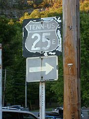
, US-25 splits into US-25E
U.S. Route 25E
U.S. Route 25E is the eastern branch of U.S. Route 25 from Newport, Tennessee, where US 25 splits into US 25E and US 25W, to North Corbin, Kentucky, where the two highways rejoin...
and US-25W. US-25E
U.S. Route 25E
U.S. Route 25E is the eastern branch of U.S. Route 25 from Newport, Tennessee, where US 25 splits into US 25E and US 25W, to North Corbin, Kentucky, where the two highways rejoin...
goes north through the cities of Morristown
Morristown, Tennessee
Morristown is a city in, and the county seat of, Hamblen County, Tennessee, United States. The population was 29,137 at the 2010 United States Census. It is the principal city of the Morristown, Tennessee Metropolitan Statistical Area, which encompasses all of Grainger, Hamblen and Jefferson counties...
, Tazewell
Tazewell, Tennessee
Tazewell is a town in Claiborne County, Tennessee, United States. The population was 2,165 at the 2000 census. It is the county seat of Claiborne County. The town is named for Henry Tazewell , a U.S. senator from Virginia.-Geography:...
, and Harrogate
Harrogate, Tennessee
Harrogate is a city in Claiborne County, Tennessee, United States. The community has been known as "Harrogate" since the 19th century, but did not incorporate as a city by that name until 1993....
, entering Kentucky
Kentucky
The Commonwealth of Kentucky is a state located in the East Central United States of America. As classified by the United States Census Bureau, Kentucky is a Southern state, more specifically in the East South Central region. Kentucky is one of four U.S. states constituted as a commonwealth...
via the Cumberland Gap Tunnel
Cumberland Gap Tunnel
The Cumberland Gap Tunnel is a tunnel that carries U.S. Route 25E under Cumberland Gap National Historical Park near the intersection of Kentucky, Tennessee, and Virginia. The east portal of the tunnel is in Tennessee and the west portal is in Kentucky; according to United States Geological Survey...
. US-25W goes west first to Knoxville
Knoxville, Tennessee
Founded in 1786, Knoxville is the third-largest city in the U.S. state of Tennessee, U.S.A., behind Memphis and Nashville, and is the county seat of Knox County. It is the largest city in East Tennessee, and the second-largest city in the Appalachia region...
then parallels I-75
Interstate 75 in Tennessee
In the U.S. state of Tennessee, Interstate 75 runs from Chattanooga to Jellico by way of Knoxville. Interstate 75 enters the East Tennessee region following the Tennessee Valley from Georgia, all the way through Knoxville to near Lake City, then climbs into the Cumberland Mountains before crossing...
into Kentucky
Kentucky
The Commonwealth of Kentucky is a state located in the East Central United States of America. As classified by the United States Census Bureau, Kentucky is a Southern state, more specifically in the East South Central region. Kentucky is one of four U.S. states constituted as a commonwealth...
.
Kentucky
Entering KentuckyKentucky
The Commonwealth of Kentucky is a state located in the East Central United States of America. As classified by the United States Census Bureau, Kentucky is a Southern state, more specifically in the East South Central region. Kentucky is one of four U.S. states constituted as a commonwealth...
from two locations, US 25E
U.S. Route 25E
U.S. Route 25E is the eastern branch of U.S. Route 25 from Newport, Tennessee, where US 25 splits into US 25E and US 25W, to North Corbin, Kentucky, where the two highways rejoin...
goes through the cities of Middlesboro and Barbourville
Barbourville, Kentucky
Each year in early October, Barbourville hosts the Daniel Boone Festival commemorating the American pioneer Daniel Boone who explored the area in 1775. The festival features open air concerts, carnival attractions, a beauty pageant, a parade, and other events....
, while US 25W continues its parallels I-75; both converge in Corbin
Corbin, Kentucky
- Economy :Originally formed by L&N Railroad, rail transport was the backbone of the local economy in the first half of the twentieth century. While the railroad continues to play an important role, the decline of the rail industry in the latter half of the twentieth century, as well as the loss...
becoming US 25 again (though US 25E continues west as a connector road to I-75). US 25 parallels I-75 throughout Kentucky
Kentucky
The Commonwealth of Kentucky is a state located in the East Central United States of America. As classified by the United States Census Bureau, Kentucky is a Southern state, more specifically in the East South Central region. Kentucky is one of four U.S. states constituted as a commonwealth...
, connecting the cities of London
London, Kentucky
-Education:All of the following schools are administered by the Laurel County School District.-Primary schools:* * * * * * * * * * * * -High schools:* * -Colleges:* Laurel Technical College* * -Notable natives:...
, Berea
Berea, Kentucky
-Demographics:As of the census of 2000, there were 9,851 people, 3,693 households, and 2,426 families residing in the city. The population density was 1,055.4 people per square mile . There were 4,115 housing units at an average density of 440.9 per square mile...
, Richmond
Richmond, Kentucky
There were 10,795 households out of which 24.4% had children under the age of 18 living with them, 35.2% were married couples living together, 12.8% had a female householder with no husband present, and 48.6% were non-families. Of all households, 34.7% were made up of individuals and 8.8% had...
, Lexington
Lexington, Kentucky
Lexington is the second-largest city in Kentucky and the 63rd largest in the US. Known as the "Thoroughbred City" and the "Horse Capital of the World", it is located in the heart of Kentucky's Bluegrass region...
, and Dry Ridge
Dry Ridge, Kentucky
Dry Ridge is a city in Grant County, Kentucky, United States. The population was 1,995 at the 2000 census.-Geography:Dry Ridge is located at ....
. US 25 ends in Covington
Covington, Kentucky
-Demographics:As of the census of 2000, there were 43,370 people, 18,257 households, and 10,132 families residing in the city. The population density was 3,301.3 people per square mile . There were 20,448 housing units at an average density of 1,556.5 per square mile...
at the Ohio
Ohio
Ohio is a Midwestern state in the United States. The 34th largest state by area in the U.S.,it is the 7th‑most populous with over 11.5 million residents, containing several major American cities and seven metropolitan areas with populations of 500,000 or more.The state's capital is Columbus...
state line over the Ohio River
Ohio River
The Ohio River is the largest tributary, by volume, of the Mississippi River. At the confluence, the Ohio is even bigger than the Mississippi and, thus, is hydrologically the main stream of the whole river system, including the Allegheny River further upstream...
; US 42
U.S. Route 42
U.S. Route 42 is an east–west United States highway that runs northeast-southwest for 355 miles from Cleveland, Ohio to Louisville, Kentucky. The route has several names including Pearl Road from Cleveland to Medina in Northeast Ohio, the Cincinnati and Lebanon Pike in southwestern Ohio and...
/US 127
U.S. Route 127
U.S. Route 127 is a long north–south United States highway in the eastern half of the United States. The southern terminus of the route is at U.S. Route 27 in Chattanooga, Tennessee. The northern terminus is at Interstate 75 near Grayling, Michigan...
continue into Cincinnati.
History
Ohio
Ohio is a Midwestern state in the United States. The 34th largest state by area in the U.S.,it is the 7th‑most populous with over 11.5 million residents, containing several major American cities and seven metropolitan areas with populations of 500,000 or more.The state's capital is Columbus...
and Michigan
Michigan
Michigan is a U.S. state located in the Great Lakes Region of the United States of America. The name Michigan is the French form of the Ojibwa word mishigamaa, meaning "large water" or "large lake"....
before Interstate 75 between Detroit and Cincinnati and Interstate 94
Interstate 94
Interstate 94 is the northernmost east–west Interstate Highway, connecting the Great Lakes and Intermountain regions of the United States. I-94's western terminus is in Billings, Montana at a junction with Interstate 90; its eastern terminus is the U.S...
between Detroit and Port Huron, Michigan
Port Huron, Michigan
Port Huron is a city in the U.S. state of Michigan and the county seat of St. Clair County. The population was 30,184 at the 2010 census. The city is adjacent to Port Huron Township but is administratively autonomous. It is joined by the Blue Water Bridge over the St. Clair River to Sarnia,...
, made most of US 25 superfluous north of Cincinnati. In Michigan, M-25
M-25 (Michigan highway)
M-25 is a state trunkline highway in the US state of Michigan. The route follows an arc-like shape closely along the Lake Huron shore of the Thumb in the eastern Lower Peninsula between Port Huron and Bay City. It serves the lakeshore resorts along Lake Huron and Saginaw Bay and generally lies...
continues as the designation of old US 25 between Port Austin
Port Austin, Michigan
Port Austin is a village in Huron County in the U.S. state of Michigan. The population was 737 at the 2000 census. The village is within Port Austin Township.-Geography:...
and Port Huron. Some old maps disagree on whether the east–west segment of what is now M-25 between Bay City
Bay City, Michigan
Bay City is a city in the U.S. state of Michigan located near the base of the Saginaw Bay on Lake Huron. As of the 2010 census, the city's population was 34,932, and is the principal city of the Bay City Metropolitan Statistical Area, which is included in the Saginaw-Bay City-Saginaw Township North...
was US 25 or M-25; for that discussion see M-25
M-25 (Michigan highway)
M-25 is a state trunkline highway in the US state of Michigan. The route follows an arc-like shape closely along the Lake Huron shore of the Thumb in the eastern Lower Peninsula between Port Huron and Bay City. It serves the lakeshore resorts along Lake Huron and Saginaw Bay and generally lies...
.
Relics of US 25 between Brownstown Township, Michigan
Brownstown Township, Michigan
Brownstown Charter Township is a charter township of Wayne County in the U.S. state of Michigan. The population was 30,627 at the 2010 census. It is part of the collection of communities known as Downriver. Brownstown's three separate segments are due to the incorporation of the cities of Flat...
, (a suburb of Detroit) and Cygnet, Ohio
Cygnet, Ohio
Cygnet is a village in Wood County, Ohio, United States. The population was 564 at the 2000 census.-Geography:Cygnet is located at .According to the United States Census Bureau, the village has a total area of , all of it land....
, include US 24, M-125
M-125 (Michigan highway)
M-125 Connector is a connector route running through Erie. It connects I-75 with M-125. It is a four lane divided highway for its entire length, named "Summit Street" in Erie. It is known internally to the Michigan Department of Transportation as "Connector 2"...
, and State Route 25.
US 25 in Michigan and Ohio was historically known as Dixie Highway
Dixie Highway
The Dixie Highway was a United States automobile highway, first planned in 1914 to connect the US Midwest with the Southern United States. It was part of the National Auto Trail system, and grew out of an earlier Miami to Montreal highway. The final result is better understood as a small network of...
, and the road is still so named in some places. It may also be known as "County Road 25-A" through some parts of Ohio.
Until 1996 when the Cumberland Gap Tunnel
Cumberland Gap Tunnel
The Cumberland Gap Tunnel is a tunnel that carries U.S. Route 25E under Cumberland Gap National Historical Park near the intersection of Kentucky, Tennessee, and Virginia. The east portal of the tunnel is in Tennessee and the west portal is in Kentucky; according to United States Geological Survey...
was opened to traffic, from Middlesboro, Kentucky, US 25E climbed the Cumberland Mountains
Cumberland Mountains
The Cumberland Mountains are a mountain range in the southeastern section of the Appalachian Mountains. They are located in southern West Virginia, western Virginia, eastern edges of Kentucky, and eastern middle Tennessee, including the Crab Orchard Mountains...
and along the historic Wilderness Road
Wilderness Road
The Wilderness Road was the principal route used by settlers for more than fifty years to reach Kentucky from the East. In 1775, Daniel Boone blazed a trail for the Transylvania Company from Fort Chiswell in Virginia through the Cumberland Gap into central Kentucky. It was later lengthened,...
, passed through the Cumberland Gap
Cumberland Gap
Cumberland Gap is a pass through the Cumberland Mountains region of the Appalachian Mountains, also known as the Cumberland Water Gap, at the juncture of the U.S. states of Tennessee, Kentucky, and Virginia...
into Virginia
Virginia
The Commonwealth of Virginia , is a U.S. state on the Atlantic Coast of the Southern United States. Virginia is nicknamed the "Old Dominion" and sometimes the "Mother of Presidents" after the eight U.S. presidents born there...
then heading south to enter Tennessee
Tennessee
Tennessee is a U.S. state located in the Southeastern United States. It has a population of 6,346,105, making it the nation's 17th-largest state by population, and covers , making it the 36th-largest by total land area...
.
Old US 25 north of the intersection of US 11W in Tennessee crossed over Clinch Mountain, following a notorious route consisting of considerable elevation gain and many switchbacks, some of which were full hairpin turn
Hairpin turn
A hairpin turn , named for its resemblance to a hairpin/bobby pin, is a bend in a road with a very acute inner angle, making it necessary for an oncoming vehicle to turn almost 180° to continue on the road. Such turns in ramps and trails may be called switchbacks in American English, by analogy...
s.