
Auckland Southern Motorway
Encyclopedia
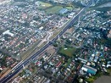
The Auckland Southern Motorway (also known as the Southern Motorway, and historically as the Auckland - Hamilton Motorway) is the major route south out of the Auckland Region
of New Zealand
. It is part of State Highway 1.
The motorway is 45 kilometres in length, with 28 junctions including termini. It runs from the Central Motorway Junction
in central Auckland, through Manukau City, Papakura
, and Drury, before terminating onto the Waikato Expressway
at the top of the Bombay Hills.
, which changes to the Southern Motorway just south of exits 426A and 426B.
For the first kilometre, the road is two lanes each way due to the constraints of the Victoria Park Viaduct
to the north. The motorway then delves deep into the Central Motorway Junction, turning eastward to form a southern boundary to the Auckland CBD, the turning south-eastwards as it leaves the junction. There are several exits northbound only through the junction, connecting to the city centre and the Northwest Motorway
.
South of the junction is the busiest section of the motorway, and busiest section of road in New Zealand carrying an average of 200,000 vehicles per day, and to cope with this, the short section between Khyber Pass Road and Gillies Avenue is five lanes wide each way. A large volume of traffic leaves at Gillies Ave to head for Auckland International Airport
.
The motorway then crosses the narrow Newmarket Viaduct
, before turning to follow the North Auckland Rail Line to Ellesllie. At Ellesllie, the motorway leaves the railway line and skirts around Penrose
, heading in a south-easterly direction towards Hamlins Hill where there are junctions with the South-Eastern Highway (Southbound exit and northbound entrance only) and the Mt Wellington Highway.
Immediately after the Mt Wellington Highway interchange, the motorway curves south to head towards the Tamaki River
. After crossing the Tamaki River, the motorway forms a boundary between the suburbs of Papatoetoe
to the west and Otara
to the east. At Manukau City Centre, the motorway has a major junction with the South-Western Motorway and then bypasses Manurewa
to the east.
In 1963, the motorway was extended at both ends, the northern terminus was moved north to Green Lane East and the southern terminus was moved south to Takanini
to allow traffic to bypass Manurewa
. Both ends were extended again in 1965, the northern end to St Marks Road at the southern end of the Newmarket Viaduct
, the southern end to Great South Road at Runciman that is south of the current Drury interchange.
In 1966, the Newmarket Viaduct was opened, and the northern terminus was extended to Khyber Pass Road, bypassing Newmarket
. An extension was also opened for northbound traffic to Symonds Street. In 1969, the motorway was extended to Wellesley Street, allow traffic in both directions to access the central city. A Symonds Street on-ramp for southbound traffic opened in 1971.
Much of the mid-1970s construction on the Southern Motorway involved building on-ramps and off-ramps in the Central Motorway Junction
. Ramps to the western side of the CBD at Nelson Street and Hobson Street opened for southbound traffic in 1973 and northbound traffic in 1977. Ramps to Grafton Road, allowing access to the Port of Auckland, opened to southbound traffic in 1975 and northbound traffic in 1978.
In 1978, the southern end was extended to Great South Road at St Stephens on the northern side of the Bombay Hills. Also in 1978, the motorway was extended from Nelson Street/Hobson Street to the Northern Motorway
at Cook Street/Wellington Street, allowing continuous motorway travel from Tristam Avenue on the North Shore to St Stephens. In 1988, ramps opened to allow direct motorway access between the Southern Motorway and the Northwestern Motorway.
In 1993, the southern end of the motorway was extended to Mill Road, near Bombay. The extension bypassed the traffic light-controlled crossroads at St Stephens, known to be an accident blackspot and causing delays of up to two hours during holiday periods. Accompanying the extension was the building of the first part of the Waikato Expressway
, which allowed traffic from the Southern Motorway to have a clear run as far as the State Highway 2
interchange on the south side of the Bombay Hills.
|-
! Territorial authority and local board(s)
! Location
! km
! #
! Destination
! Notes
|-
| rowspan=7| Auckland
– Waitemata Board
| rowspan="6"| Auckland CBD
| 427.0
|
| SH 1 Northern Motorway
north – North Shore
, Whangarei
| Southern Motorway begins
|-
| 427.4
| 427
| Nelson Street – City Centre (West)
| Northbound exit and southbound entrance
|-
| 427.8
| 428
| SH 16
SH 16
Northwest Motorway
west – Waitakere
, Helensville
| Northbound exit and southbound entrance
|-
| rowspan=3| 428.4
| 429C
| SH 16
Northwest Motorway
east – Port
| Northbound exit and southbound entrance
|-
| 429B
| Wellesley Street – City Centre (East)
| Northbound exit and southbound entrance
|-
| 429A
| Symonds Street – City Centre (South)
| Northbound exit and southbound entrance
|-
| rowspan=3| Newmarket
| 428.9
| 430
| Route 12 Khyber Pass Road
| Northbound exit and southbound entrance
|-
| rowspan=2| Auckland – Waitemata/Albert-Eden
Boards
| 429.5
| 431
| Route 12 Gillies Ave – Airport, Newmarket
, Epsom
| Southbound exit and northbound entrance
|-
| 431.0
|
| Newmarket Viaduct
|
|-
| rowspan=3| Auckland – Ōrākei Board
| Remuera West
| 431.8
| 432
| Market Road
| Southbound and northbound exits
|-
| Greenlane
| 433.1
| 433
| Route 9 Green Lane East – Remuera
, Greenlane
|-
| Ellerslie
| 434.1
| 434
| Tecoma Street – Ellerslie
, Racecourse
| Southbound exit and entrance
|-
| Auckland – Ōrākei/Maungakiekie-Tāmaki
Boards
| Ellerslie South
| 435.3
| 435
| Route 5 Ellerslie-Panmure Highway – Ellerslie, Penrose
, Panmure
, Racecourse
|
|-
| rowspan=2| Auckland – Maungakiekie-Tāmaki Board
| rowspan="2"|Mt Wellington South
| 437.6
| 437
| Route 10 South-Eastern Highway – Airport, Onehunga
, Pakuranga
, Howick
| No northbound exit (Access available via exit 438)
|-
| 438.4
| 438
| Route 6 Mt Wellington Highway – Sylvia Park
, Mt Wellington, Panmure, Onehunga
|
|-
| Auckland – Mangere-Otahuhu Board
| Otahuhu East
| 441.1
| 441
| Princes Street – Otahuhu
, Middlemore
, Hospital
|
|-
| rowspan=3| Auckland – Otara-Papatoetoe Board
| Otara West
| 442.6
| 443
| Highbrook Drive
|
|-
| Otara
| 443.9
| 444
| Route 8 East Tamaki Road – Otara
, East Tamaki
, Papatoetoe
|
|-
| rowspan="4"| Manukau CBD
| 446.8
| 447
| Route 30 Te Irirangi Drive
| Southbound exit and northbound entrance
|-
| rowspan=3| Auckland – Otara-Papatoetoe/Manurewa Boards
| 448.0
| 448
| Redoubt Road – Manukau
, Airport
| No northbound exit (Access available via exit 449A).
|-
| 448.7
| 449B
| SH 20 Southwest Motorway
– Auckland Airport
|
|-
| 448.7
| 449A
| Great South Road – Manukau, Airport
| Northbound exit only
|-
| Auckland – Manurewa Board
| Manurewa
| 450.8
| 451
| Hill Road – Manurewa
| No northbound exit (Access available via exit 453)
|-
| rowspan=3| Auckland – Papakura Board
| Takanini
| 453.8
| 453
| Route 3 Great South Road – Takanini, Manurewa
|
|-
| Pahurehure
| 457.9
| 458
| Beach Road/Hingaia Road – Papakura, Karaka
|
|-
| rowspan="2"| Drury
| 459.9
|
|
 Papakura Service Centre
| Southbound only
|-
| Auckland – Papakura/Franklin Boards
| 461.0
| 461
| SH 22 Great South Road – Drury, Pukekohe
|
|-
| rowspan=3| Auckland – Franklin Board
| Ramarama
| 465.6
| 466
| Ararimu Road – Ramarama
|
|-
| rowspan=2| Bombay
| 471.5
| 471
| Bombay, Pukekohe
Bombay Service Centre
| Southbound exit and northbound entrance
|-
| 472.0
|
| SH 1/Thermal Explorer Highway Waikato Expressway
south – Hamilton
, Tauranga
| Southern Motorway ends
In some areas, the Southern Motorway forms the border between two local boards. Local boards are listed so that the board on left side in kilometre-ascending direction (i.e. the board on the eastern side of the motorway) is listed first.
Distances are measured form the start of State Highway 1 at Cape Reinga
.
Auckland Region
The Auckland Region was one of the sixteen regions of New Zealand, named for the city of Auckland, the country's largest urban area. With one third of the nation's residents, it was by far the biggest population and economy of any region of New Zealand, but the second-smallest land area.On 1...
of New Zealand
New Zealand
New Zealand is an island country in the south-western Pacific Ocean comprising two main landmasses and numerous smaller islands. The country is situated some east of Australia across the Tasman Sea, and roughly south of the Pacific island nations of New Caledonia, Fiji, and Tonga...
. It is part of State Highway 1.
The motorway is 45 kilometres in length, with 28 junctions including termini. It runs from the Central Motorway Junction
Central Motorway Junction
The Central Motorway Junction or CMJ , is the intersection of New Zealand State Highways 1 and 16, just south of the central business district of Auckland, New Zealand...
in central Auckland, through Manukau City, Papakura
Papakura
The Papakura District was the name of a local council territory in New Zealand's Auckland Region that existed from 1989 until 2010. The area made up the southernmost part of the Auckland metropolitan area....
, and Drury, before terminating onto the Waikato Expressway
Waikato Expressway
The Waikato Expressway is a dual carriageway section of State Highway 1 in the Waikato region of the North Island of New Zealand and forms part of the link between Auckland and Hamilton...
at the top of the Bombay Hills.
Route
The Southern Motorway starts just north of the Central Motorway Junction (Spaghetti Junction) on the west side of central Auckland. The motorway is a direct extension of the Northern MotorwayAuckland Northern Motorway
The Auckland Northern Motorway is a major motorway in the Auckland Region of New Zealand, linking central Auckland City and Puhoi in the Rodney District, via the Hibiscus Coast and North Shore...
, which changes to the Southern Motorway just south of exits 426A and 426B.
For the first kilometre, the road is two lanes each way due to the constraints of the Victoria Park Viaduct
Victoria Park Viaduct
The Victoria Park Viaduct is a major motorway viaduct carrying the Auckland Northern Motorway over the Victoria Park area in Auckland City, New Zealand...
to the north. The motorway then delves deep into the Central Motorway Junction, turning eastward to form a southern boundary to the Auckland CBD, the turning south-eastwards as it leaves the junction. There are several exits northbound only through the junction, connecting to the city centre and the Northwest Motorway
Northwest Motorway
The Northwestern Motorway , part of State Highway 16 , is the major western route and secondary northern route out of Auckland in New Zealand...
.
South of the junction is the busiest section of the motorway, and busiest section of road in New Zealand carrying an average of 200,000 vehicles per day, and to cope with this, the short section between Khyber Pass Road and Gillies Avenue is five lanes wide each way. A large volume of traffic leaves at Gillies Ave to head for Auckland International Airport
Auckland International Airport
Auckland Airport is the largest and busiest airport in New Zealand with over 13 million passengers a year, expected to more than double by 2025...
.
The motorway then crosses the narrow Newmarket Viaduct
Newmarket Viaduct
The Newmarket Viaduct, sometimes considered 'one of the most distinctive engineering features' of New Zealand, is a six-lane State highway viaduct in Auckland, the country's largest city. Carrying the Southern Motorway over the Newmarket suburb area southeast of the CBD of the city, the 700 m long...
, before turning to follow the North Auckland Rail Line to Ellesllie. At Ellesllie, the motorway leaves the railway line and skirts around Penrose
Penrose, New Zealand
Penrose is an industrial suburb in Auckland City, New Zealand. It is located to the southeast of the city centre, at a distance of about nine kilometres, between the suburbs of Oranga and Mount Wellington, and close to the Mangere Inlet, an arm of the Manukau Harbour...
, heading in a south-easterly direction towards Hamlins Hill where there are junctions with the South-Eastern Highway (Southbound exit and northbound entrance only) and the Mt Wellington Highway.
Immediately after the Mt Wellington Highway interchange, the motorway curves south to head towards the Tamaki River
Tamaki River
The Tamaki River is, despite its name, mostly an estuarial arm and harbour of the Hauraki Gulf, within the city of Auckland in New Zealand. It extends south for 15 kilometres from its mouth between the Auckland suburb of Saint Heliers and the long thin peninsula of Bucklands Beach, which reaches...
. After crossing the Tamaki River, the motorway forms a boundary between the suburbs of Papatoetoe
Papatoetoe
Papatoetoe is a suburb in the Auckland conurbation in northern New Zealand. One of the larger suburbs of the area commonly known as South Auckland, it is located to the northwest of central Manukau, and 18 kilometres southeast of Auckland city centre....
to the west and Otara
Otara
Ōtara is a suburb of Auckland, New Zealand, situated 18 kilometres to the southeast of the Auckland CBD. Ōtara lies near the head of the Tāmaki River , which extends south towards the Manukau Harbour...
to the east. At Manukau City Centre, the motorway has a major junction with the South-Western Motorway and then bypasses Manurewa
Manurewa
Manurewa is the southernmost major suburb of Manukau City, one of the four cities that make up the metropolitan area of Auckland in the North Island of New Zealand. It is located 6km south of the Manukau City Centre, and 26km southeast of the Auckland CBD....
to the east.
History
The first section of the Southern Motorway opened on 16 July 1953, between Ellerslie-Panmure Highway and Mount Wellington Highway (Exit 438). It was quickly extended southwards in 1955 to Redoubt Road to provide a higher-capacity and faster alternative to Great South Road between Ellerslie and Wiri.In 1963, the motorway was extended at both ends, the northern terminus was moved north to Green Lane East and the southern terminus was moved south to Takanini
Takanini
Takanini is a suburb of Auckland, and until 2010 is under authority of the Papakura District Council, in northern New Zealand. Located on the shores of the Pahurehure Inlet, it is located at , 28 kilometres southeast of the Auckland CBD....
to allow traffic to bypass Manurewa
Manurewa
Manurewa is the southernmost major suburb of Manukau City, one of the four cities that make up the metropolitan area of Auckland in the North Island of New Zealand. It is located 6km south of the Manukau City Centre, and 26km southeast of the Auckland CBD....
. Both ends were extended again in 1965, the northern end to St Marks Road at the southern end of the Newmarket Viaduct
Newmarket Viaduct
The Newmarket Viaduct, sometimes considered 'one of the most distinctive engineering features' of New Zealand, is a six-lane State highway viaduct in Auckland, the country's largest city. Carrying the Southern Motorway over the Newmarket suburb area southeast of the CBD of the city, the 700 m long...
, the southern end to Great South Road at Runciman that is south of the current Drury interchange.
In 1966, the Newmarket Viaduct was opened, and the northern terminus was extended to Khyber Pass Road, bypassing Newmarket
Newmarket, New Zealand
Newmarket is an Auckland suburb to the south-east of the central business district. With its high building density, especially of retail shops, it is considered New Zealand's premier retailing area, and a rival of local competitor Auckland CBD...
. An extension was also opened for northbound traffic to Symonds Street. In 1969, the motorway was extended to Wellesley Street, allow traffic in both directions to access the central city. A Symonds Street on-ramp for southbound traffic opened in 1971.
Much of the mid-1970s construction on the Southern Motorway involved building on-ramps and off-ramps in the Central Motorway Junction
Central Motorway Junction
The Central Motorway Junction or CMJ , is the intersection of New Zealand State Highways 1 and 16, just south of the central business district of Auckland, New Zealand...
. Ramps to the western side of the CBD at Nelson Street and Hobson Street opened for southbound traffic in 1973 and northbound traffic in 1977. Ramps to Grafton Road, allowing access to the Port of Auckland, opened to southbound traffic in 1975 and northbound traffic in 1978.
In 1978, the southern end was extended to Great South Road at St Stephens on the northern side of the Bombay Hills. Also in 1978, the motorway was extended from Nelson Street/Hobson Street to the Northern Motorway
Auckland Northern Motorway
The Auckland Northern Motorway is a major motorway in the Auckland Region of New Zealand, linking central Auckland City and Puhoi in the Rodney District, via the Hibiscus Coast and North Shore...
at Cook Street/Wellington Street, allowing continuous motorway travel from Tristam Avenue on the North Shore to St Stephens. In 1988, ramps opened to allow direct motorway access between the Southern Motorway and the Northwestern Motorway.
In 1993, the southern end of the motorway was extended to Mill Road, near Bombay. The extension bypassed the traffic light-controlled crossroads at St Stephens, known to be an accident blackspot and causing delays of up to two hours during holiday periods. Accompanying the extension was the building of the first part of the Waikato Expressway
Waikato Expressway
The Waikato Expressway is a dual carriageway section of State Highway 1 in the Waikato region of the North Island of New Zealand and forms part of the link between Auckland and Hamilton...
, which allowed traffic from the Southern Motorway to have a clear run as far as the State Highway 2
New Zealand State Highway 2
State Highway 2 is one of New Zealand's eight national highways. With the exception of State Highway 1, which runs the length of both of the country's main islands, SH 2 is the longest highway in the North Island...
interchange on the south side of the Bombay Hills.
Future
Several major projects are planned for the Southern Motorway within the next ten years (from 2008). From north to south they are:- Newmarket ViaductNewmarket ViaductThe Newmarket Viaduct, sometimes considered 'one of the most distinctive engineering features' of New Zealand, is a six-lane State highway viaduct in Auckland, the country's largest city. Carrying the Southern Motorway over the Newmarket suburb area southeast of the CBD of the city, the 700 m long...
Replacement - The existing Newmarket Viaduct is six lanes wide, congested, and does not meet today's earthquake standards. Construction began in April 2009 on a new, seven lane structure. There will be one extra southbound lane (four in total) and three northbound with the capability to add a fourth lane in the future. The project is forecast to cost around NZ$New Zealand dollarThe New Zealand dollar is the currency of New Zealand. It also circulates in the Cook Islands , Niue, Tokelau, and the Pitcairn Islands. It is divided into 100 cents....
215 million and be completed by 2013.
- Newmarket Viaduct to Greenlane Auxiliary Lane - A fourth lane will be constructed south of the existing Newmarket Viaduct to the Greenlane Interchange. The lane will be used to carry the extra traffic from the extra fourth southbound lane on the new Newmarket Viaduct. The project is currently at the design stage, and will cost in the region of $5 million to $20 million.
- Green Lane Interchange Improvements - A combined project between Transit New ZealandTransit New ZealandTransit New Zealand was, from 1989 to 2008, the New Zealand Crown entity responsible for operating and planning the New Zealand State Highway network...
and Auckland City CouncilAuckland City CouncilAuckland City Council was the local government authority representing Auckland City, New Zealand, and was amalgamated into the Auckland Council on 1 November 2010. It was an elected body representing the 404,658 residents of the city...
will see the Greenlane Interchange upgraded to provide dedicated turn lanes, improved traffic flow, and improved pedestrian and cycling facilities. The project is due for completion in 2008.
- SH 20 Southwest Motorway Manukau Extension - The Southwestern Motorway is currently been extended south to meet the Southern Motorway at Manukau. For the connection to State Highway 1, alterations to the existing junction (Exits 448/449) are being made to accommodate a directional T junction for direct access between the two motorways. The new interchange will be fully operational in August 2010 when the Southwestern Motorway extension opens.
- SH1-20 East-West corridor linking the southern and western motorways between East Tamaki and Onehunga- Various investigations from the 1960s have reconfirmed the need for the link, the latest showing that if not completed by 2020, traffic in the area will be reduced to a crawl throughout most working days. Freight traffic volumes on local roads along the route are higher than on most state highways across New Zealand. The Eastern Corridor or AMETI (Auckland-Manukau Eastern Transit Initiative) to provide efficient access to the fast growing business and residential suburbs of east and south east Auckland. Multi-billion dollar economic benefits have been shown for this project. Currently the project is being built in small stages that stretch its completion out to the 2030s.
Interchanges
{| class="wikitable"|-
! Territorial authority and local board(s)
! Location
! km
! #
Exit number
An exit number is a number assigned to a road junction, usually an exit from a freeway. It is usually marked on the same sign as the destinations of the exit, as well as a sign in the gore....
! Destination
! Notes
|-
| rowspan=7| Auckland
Auckland Council
The Auckland Council is the council for the Auckland Region in New Zealand. It began operating on 1 November 2010, combining the functions of the existing regional council and the region's seven previous city and district councils into one "super council" or "super city" governed by a mayor, 20...
– Waitemata Board
Waitemata Local Board
The Waitemata Local Board is one of the 21 local boards of the Auckland Council, which will replace Auckland's existing eight councils on 1 November 2010....
| rowspan="6"| Auckland CBD
Auckland CBD
The Auckland CBD is the geographical and economic heart of the Auckland metropolitan area. Bounded by several major motorways and by the harbour coastline in the north, it is surrounded further out by mostly suburban areas...
| 427.0
|
|
SH 1 Northern MotorwayAuckland Northern Motorway
The Auckland Northern Motorway is a major motorway in the Auckland Region of New Zealand, linking central Auckland City and Puhoi in the Rodney District, via the Hibiscus Coast and North Shore...
north – North Shore
North Shore, New Zealand
North Shore City was the name of a city that existed in the Auckland region of New Zealand from 1989 until 2010. The city had a population of making it the fourth most populous city in New Zealand prior to November 2010...
, Whangarei
Whangarei
Whangarei, pronounced , is the northernmost city in New Zealand and the regional capital of Northland Region. Although commonly classified as a city, it is officially part of the Whangarei District, administered by the Whangarei District Council a local body created in 1989 to administer both the...
| Southern Motorway begins
|-
| 427.4
| 427
| Nelson Street – City Centre (West)
| Northbound exit and southbound entrance
|-
| 427.8
| 428
|
SH 16New Zealand State Highway 16
State Highway 16 is a New Zealand state highway linking Auckland City with Wellsford, via Auckland's Northwestern Motorway, Helensville and Kaukapakapa...
Northwest Motorway
Northwest Motorway
The Northwestern Motorway , part of State Highway 16 , is the major western route and secondary northern route out of Auckland in New Zealand...
west – Waitakere
Waitakere
Waitakere City was the name of a city which existed from 1989 until 2010 in the Auckland region. It was New Zealand's fifth largest city, with an annual growth of about 2%...
, Helensville
| Northbound exit and southbound entrance
|-
| rowspan=3| 428.4
| 429C
|
SH 16New Zealand State Highway 16
State Highway 16 is a New Zealand state highway linking Auckland City with Wellsford, via Auckland's Northwestern Motorway, Helensville and Kaukapakapa...
Northwest Motorway
Northwest Motorway
The Northwestern Motorway , part of State Highway 16 , is the major western route and secondary northern route out of Auckland in New Zealand...
east – Port
| Northbound exit and southbound entrance
|-
| 429B
| Wellesley Street – City Centre (East)
| Northbound exit and southbound entrance
|-
| 429A
| Symonds Street – City Centre (South)
| Northbound exit and southbound entrance
|-
| rowspan=3| Newmarket
| 428.9
| 430
| Route 12 Khyber Pass Road
| Northbound exit and southbound entrance
|-
| rowspan=2| Auckland – Waitemata/Albert-Eden
Albert-Eden Local Board
The Albert-Eden Local Board is one of the 21 local boards of the Auckland Council, which will replace Auckland's existing eight councils on 1 November 2010....
Boards
| 429.5
| 431
|
Route 12 Gillies Ave – Airport, NewmarketNewmarket, New Zealand
Newmarket is an Auckland suburb to the south-east of the central business district. With its high building density, especially of retail shops, it is considered New Zealand's premier retailing area, and a rival of local competitor Auckland CBD...
, Epsom
Epsom, New Zealand
Epsom is a suburb of Auckland, New Zealand. It is located in the centre of the Auckland isthmus between Mount Eden and One Tree Hill, south of Newmarket, and five km south of the city centre.-Notable features:...
| Southbound exit and northbound entrance
|-
| 431.0
|
|
Newmarket ViaductNewmarket Viaduct
The Newmarket Viaduct, sometimes considered 'one of the most distinctive engineering features' of New Zealand, is a six-lane State highway viaduct in Auckland, the country's largest city. Carrying the Southern Motorway over the Newmarket suburb area southeast of the CBD of the city, the 700 m long...
|
|-
| rowspan=3| Auckland – Ōrākei Board
| Remuera West
| 431.8
| 432
| Market Road
| Southbound and northbound exits
|-
| Greenlane
| 433.1
| 433
| Route 9 Green Lane East – Remuera
Remuera
Remuera is a residential suburban area within Auckland city, in the North Island of New Zealand. It is located four kilometres to the southeast of the city centre...
, Greenlane
Greenlane
Greenlane is a suburb of Auckland, New Zealand.The Greenlane shops are the main shopping centre for the suburb of Epsom and are situated at the intersection of Manukau Road and Green Lane West...
|-
| Ellerslie
| 434.1
| 434
| Tecoma Street – Ellerslie
Ellerslie, New Zealand
Ellerslie is a suburb of the city of Auckland, New Zealand. It is seven kilometres to the southeast of the city centre, close to State Highway 1...
, Racecourse
Ellerslie Racecourse
Ellerslie Racecourse is the main racecourse in Ellerslie, Auckland, New Zealand for thoroughbred racehorses. It is an undulating, grass circuit of approximately 1,900 m.-History:The first race meeting was held at Ellerslie on 25 May 1874...
| Southbound exit and entrance
|-
| Auckland – Ōrākei/Maungakiekie-Tāmaki
Maungakiekie-Tamaki Local Board
The Maungakiekie-Tāmaki Local Board is one of the 21 local boards of the Auckland Council, which replaced Auckland's eight councils on 1 November 2010....
Boards
| Ellerslie South
| 435.3
| 435
| Route 5 Ellerslie-Panmure Highway – Ellerslie, Penrose
Penrose, New Zealand
Penrose is an industrial suburb in Auckland City, New Zealand. It is located to the southeast of the city centre, at a distance of about nine kilometres, between the suburbs of Oranga and Mount Wellington, and close to the Mangere Inlet, an arm of the Manukau Harbour...
, Panmure
Panmure, New Zealand
Panmure is a south-eastern suburb of Auckland City, in the North Island of New Zealand. It is located 11 kilometres southeast of the city centre, close to the western banks of the Tamaki River and the northern shore of the Panmure Basin...
, Racecourse
|
|-
| rowspan=2| Auckland – Maungakiekie-Tāmaki Board
| rowspan="2"|Mt Wellington South
| 437.6
| 437
|
Route 10 South-Eastern Highway – Airport, OnehungaOnehunga
Onehunga is a suburb of Auckland City, New Zealand and the location of the Port of Onehunga, the city's small port on the Manukau Harbour. It is eight kilometres south of the city centre, close to the volcanic cone of One Tree Hill, Maungakiekie....
, Pakuranga
Pakuranga
Pakuranga is an eastern suburb of Auckland, in northern New Zealand. Pakuranga covers a series of low ridges and previously swampy flats, now drained, that lie between the Pakuranga Creek and Tamaki River, two estuarial arms of the Hauraki Gulf...
, Howick
Howick, New Zealand
Howick is an eastern suburb of Auckland, New Zealand, forming part of what is sometimes called East Auckland. Due to the relatively numerous remaining heritage buildings and other historical remnants from its early European settlement past, it has been called "perhaps Auckland's most historically...
| No northbound exit (Access available via exit 438)
|-
| 438.4
| 438
| Route 6 Mt Wellington Highway – Sylvia Park
Sylvia Park
Sylvia Park is a large business park and shopping centre in the Auckland, New Zealand suburb of Mount Wellington. Less commonly known, the area around the centre is also called Sylvia Park...
, Mt Wellington, Panmure, Onehunga
|
|-
| Auckland – Mangere-Otahuhu Board
| Otahuhu East
| 441.1
| 441
| Princes Street – Otahuhu
Otahuhu
Otahuhu is a suburb of Auckland. It is located to the southeast of the city centre, on a narrow isthmus between an arm of the Manukau Harbour to the west and the Tamaki River estuary to the east...
, Middlemore
Middlemore
Middlemore is a suburb of Manukau City, one of the four cities that make up the conurbation of Auckland, New Zealand, in northern New Zealand....
, Hospital
Middlemore Hospital
Middlemore Hospital is a major hospital in the suburb of Middlemore, Manukau City, New Zealand. The largest hospital operated by the Counties Manukau District Health Board, it offers tertiary-level care as well as a range of other health and social services for the Counties Manukau...
|
|-
| rowspan=3| Auckland – Otara-Papatoetoe Board
| Otara West
| 442.6
| 443
| Highbrook Drive
|
|-
| Otara
| 443.9
| 444
| Route 8 East Tamaki Road – Otara
Otara
Ōtara is a suburb of Auckland, New Zealand, situated 18 kilometres to the southeast of the Auckland CBD. Ōtara lies near the head of the Tāmaki River , which extends south towards the Manukau Harbour...
, East Tamaki
East Tamaki
East Tamaki is a suburb of Auckland, New Zealand. This is a mixed residential, light industry and retail area which is growing rapidly. Prior to the 1960s this was largely a dairy farming area. A landmark is Smales Mountain which in 2010 has the remains of an old Pa, a stone field garden, an early...
, Papatoetoe
Papatoetoe
Papatoetoe is a suburb in the Auckland conurbation in northern New Zealand. One of the larger suburbs of the area commonly known as South Auckland, it is located to the northwest of central Manukau, and 18 kilometres southeast of Auckland city centre....
|
|-
| rowspan="4"| Manukau CBD
| 446.8
| 447
| Route 30 Te Irirangi Drive
| Southbound exit and northbound entrance
|-
| rowspan=3| Auckland – Otara-Papatoetoe/Manurewa Boards
| 448.0
| 448
| Redoubt Road – Manukau
Manukau
Manukau City was a large territorial authority in Auckland, New Zealand. The city was sometimes referred to as South Auckland, but this term did not possess official recognition and did not encompass areas like East Auckland, which was previously within the official boundaries of Manukau City...
, Airport
| No northbound exit (Access available via exit 449A).
|-
| 448.7
| 449B
|
SH 20 Southwest MotorwaySouthwest Motorway
State Highway 20, also known as either the Southwestern Motorway, or the Mangere Motorway, is a New Zealand State Highway linking State Highway 1 at Manukau City Centre with Mount Roskill, via Mangere and Onehunga...
– Auckland Airport
Auckland International Airport
Auckland Airport is the largest and busiest airport in New Zealand with over 13 million passengers a year, expected to more than double by 2025...
|
|-
| 448.7
| 449A
| Great South Road – Manukau, Airport
| Northbound exit only
|-
| Auckland – Manurewa Board
| Manurewa
| 450.8
| 451
| Hill Road – Manurewa
| No northbound exit (Access available via exit 453)
|-
| rowspan=3| Auckland – Papakura Board
| Takanini
| 453.8
| 453
| Route 3 Great South Road – Takanini, Manurewa
|
|-
| Pahurehure
| 457.9
| 458
| Beach Road/Hingaia Road – Papakura, Karaka
|
|-
| rowspan="2"| Drury
| 459.9
|
|
Papakura Service Centre| Southbound only
|-
| Auckland – Papakura/Franklin Boards
| 461.0
| 461
|
SH 22 Great South Road – Drury, PukekohePukekohe
Pukekohe is a town in the Auckland Region of the North Island of New Zealand. Located at the southern edge of the Auckland Region, it is approximately 50 kilometres south of Auckland City, between the southern shore of the Manukau Harbour and the mouth of the Waikato River. The hills of Pukekohe...
|
|-
| rowspan=3| Auckland – Franklin Board
| Ramarama
| 465.6
| 466
| Ararimu Road – Ramarama
|
|-
| rowspan=2| Bombay
| 471.5
| 471
| Bombay, Pukekohe
Bombay Service Centre| Southbound exit and northbound entrance
|-
| 472.0
|
|
SH 1/Thermal Explorer Highway Waikato ExpresswayWaikato Expressway
The Waikato Expressway is a dual carriageway section of State Highway 1 in the Waikato region of the North Island of New Zealand and forms part of the link between Auckland and Hamilton...
south – Hamilton
Hamilton, New Zealand
Hamilton is the centre of New Zealand's fourth largest urban area, and Hamilton City is the country's fourth largest territorial authority. Hamilton is in the Waikato Region of the North Island, approximately south of Auckland...
, Tauranga
Tauranga
Tauranga is the most populous city in the Bay of Plenty region, in the North Island of New Zealand.It was settled by Europeans in the early 19th century and was constituted as a city in 1963...
| Southern Motorway ends
In some areas, the Southern Motorway forms the border between two local boards. Local boards are listed so that the board on left side in kilometre-ascending direction (i.e. the board on the eastern side of the motorway) is listed first.
Distances are measured form the start of State Highway 1 at Cape Reinga
Cape Reinga
Cape Reinga is the northwesternmost tip of the Aupouri Peninsula, at the northern end of the North Island of New Zealand. Cape Reinga is located over 100 km north of the nearest small town of Kaitaia. State Highway 1 extends all the way to the Cape, but until 2010 was unsealed gravel road for the...
.
See also
- List of motorways in New Zealand
- List of motorways, expressways, and highways in Auckland