
Pakuranga
Encyclopedia
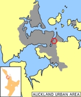
Pakuranga is an eastern suburb of Auckland
, in northern New Zealand
. Pakuranga covers a series of low ridges and previously swampy flats, now drained, that lie between the Pakuranga Creek and Tamaki River
, two estuarial
arms of the Hauraki Gulf
. It is located to the north of Manukau and 15 kilometres southeast of the Auckland CBD
.
for battle of the sunlight or battle of the sun's rays. This peculiar name is the result of a legend about a battle between mythical nocturnal creatures. The battle raged fiercely until a Maori priest caused the sun to rise earlier than expected. Caught by surprise in the rays of the sun, the monsters perished.
Pakuranga itself had a low Maori population in the early days due to the swampy nature of much of the land. Three prominent pa
were at Pidgeon Mountain and two at Panmure on a cliff, at the intersection of the Tamaki River and the inlet to the Panmure Basin. During the attacks by Ngapuhi in the Musket wars in late September 1820, most of the population were killed, eaten , taken prisoner or fled south to the Waikato.
In early European times, it was a sparsely settled dairy farming area between the townships of Panmure and Howick. In the 1920s and 30s it was served by a bus that ran from Bucklands Beach known as the "shiek". In the 1930s a concrete road was built between these townships that improved transport times for people and milk. Although there had been a hinged steel bridge over the Tamaki River
to Panmure
from as early as 1866, it was not until the construction of a sturdier structure across the Tamaki River in the 1950s, coinciding with a demand for more settlement land and the increasing levels of car ownership, that Pakuranga became suburban. In fact, for a while in the 70s it was considered the typical New Zealand middle class suburb, 'Vim Valley', after 'a typical Pakuranga housewife' was featured in a famous cleaning product ad.
Many of the American style houses of the 1950s and 1960s are still noticeable but much of the appeal of the early suburb lay in the proximity of untouched countryside. Since the 1970s Pakuranga has been surrounded and engulfed by suburban developments on a much larger scale but of less architectural merit. Traffic travelling to and from these suburbs and the centre of Auckland is largely funnelled through the roadways of Pakuranga which has degraded the area somewhat as well.
Despite this today Pakuranga remains an attractive suburb, with some light industry, centred around the Pakuranga Town Centre 1965, now known as "The Plaza". The mall was one of the first (probably the first) malls of the modern age in New Zealand, incorporating Farmers
and George Court department stores. The mall itself has been transformed several times since it first went up and retains little of the 1960s style it once had. The Te Tuhi Centre for the Arts is located nearby.
Pakuranga College was built on a low lying swampy piece of land south of Pigeon Mountain opening in May 1961 with a roll of 428. Edgewater College was built on low lying swamp land known as Fletcher's Bog near the Tamaki River. It opened in 1968. Schools in Pakuranga also include the private school Saint Kentigern College
.
Auckland
The Auckland metropolitan area , in the North Island of New Zealand, is the largest and most populous urban area in the country with residents, percent of the country's population. Auckland also has the largest Polynesian population of any city in the world...
, in northern New Zealand
New Zealand
New Zealand is an island country in the south-western Pacific Ocean comprising two main landmasses and numerous smaller islands. The country is situated some east of Australia across the Tasman Sea, and roughly south of the Pacific island nations of New Caledonia, Fiji, and Tonga...
. Pakuranga covers a series of low ridges and previously swampy flats, now drained, that lie between the Pakuranga Creek and Tamaki River
Tamaki River
The Tamaki River is, despite its name, mostly an estuarial arm and harbour of the Hauraki Gulf, within the city of Auckland in New Zealand. It extends south for 15 kilometres from its mouth between the Auckland suburb of Saint Heliers and the long thin peninsula of Bucklands Beach, which reaches...
, two estuarial
Estuary
An estuary is a partly enclosed coastal body of water with one or more rivers or streams flowing into it, and with a free connection to the open sea....
arms of the Hauraki Gulf
Hauraki Gulf
The Hauraki Gulf is a coastal feature of the North Island of New Zealand. It has a total area of 4000 km², and lies between the Auckland Region, the Hauraki Plains, the Coromandel Peninsula and Great Barrier Island...
. It is located to the north of Manukau and 15 kilometres southeast of the Auckland CBD
Auckland CBD
The Auckland CBD is the geographical and economic heart of the Auckland metropolitan area. Bounded by several major motorways and by the harbour coastline in the north, it is surrounded further out by mostly suburban areas...
.
History
The suburb's name is MaoriMaori language
Māori or te reo Māori , commonly te reo , is the language of the indigenous population of New Zealand, the Māori. It has the status of an official language in New Zealand...
for battle of the sunlight or battle of the sun's rays. This peculiar name is the result of a legend about a battle between mythical nocturnal creatures. The battle raged fiercely until a Maori priest caused the sun to rise earlier than expected. Caught by surprise in the rays of the sun, the monsters perished.
Pakuranga itself had a low Maori population in the early days due to the swampy nature of much of the land. Three prominent pa
Pa (Maori)
The word pā can refer to any Māori village or settlement, but in traditional use it referred to hillforts fortified with palisades and defensive terraces and also to fortified villages. They first came into being about 1450. They are located mainly in the North Island north of lake Taupo...
were at Pidgeon Mountain and two at Panmure on a cliff, at the intersection of the Tamaki River and the inlet to the Panmure Basin. During the attacks by Ngapuhi in the Musket wars in late September 1820, most of the population were killed, eaten , taken prisoner or fled south to the Waikato.
In early European times, it was a sparsely settled dairy farming area between the townships of Panmure and Howick. In the 1920s and 30s it was served by a bus that ran from Bucklands Beach known as the "shiek". In the 1930s a concrete road was built between these townships that improved transport times for people and milk. Although there had been a hinged steel bridge over the Tamaki River
Tamaki River
The Tamaki River is, despite its name, mostly an estuarial arm and harbour of the Hauraki Gulf, within the city of Auckland in New Zealand. It extends south for 15 kilometres from its mouth between the Auckland suburb of Saint Heliers and the long thin peninsula of Bucklands Beach, which reaches...
to Panmure
Panmure, New Zealand
Panmure is a south-eastern suburb of Auckland City, in the North Island of New Zealand. It is located 11 kilometres southeast of the city centre, close to the western banks of the Tamaki River and the northern shore of the Panmure Basin...
from as early as 1866, it was not until the construction of a sturdier structure across the Tamaki River in the 1950s, coinciding with a demand for more settlement land and the increasing levels of car ownership, that Pakuranga became suburban. In fact, for a while in the 70s it was considered the typical New Zealand middle class suburb, 'Vim Valley', after 'a typical Pakuranga housewife' was featured in a famous cleaning product ad.
Many of the American style houses of the 1950s and 1960s are still noticeable but much of the appeal of the early suburb lay in the proximity of untouched countryside. Since the 1970s Pakuranga has been surrounded and engulfed by suburban developments on a much larger scale but of less architectural merit. Traffic travelling to and from these suburbs and the centre of Auckland is largely funnelled through the roadways of Pakuranga which has degraded the area somewhat as well.
Despite this today Pakuranga remains an attractive suburb, with some light industry, centred around the Pakuranga Town Centre 1965, now known as "The Plaza". The mall was one of the first (probably the first) malls of the modern age in New Zealand, incorporating Farmers
Farmers (department store)
The Farmers Trading Company is a New Zealand mid-market department store chain. Based in Flat Bush in Auckland, Farmers operates 56 stores across New Zealand, specialising in fashion, beauty, home-wares and furniture.- History :...
and George Court department stores. The mall itself has been transformed several times since it first went up and retains little of the 1960s style it once had. The Te Tuhi Centre for the Arts is located nearby.
Schools
There was no school in the area before the 1960s so children had to walk or ride horses to the old Howick school which was located across from the Highland Park shops. The old school was moved to the old village display in Bells Rd, Pakuranga.Pakuranga College was built on a low lying swampy piece of land south of Pigeon Mountain opening in May 1961 with a roll of 428. Edgewater College was built on low lying swamp land known as Fletcher's Bog near the Tamaki River. It opened in 1968. Schools in Pakuranga also include the private school Saint Kentigern College
Saint Kentigern College
Saint Kentigern College is a private, co-educational Presbyterian secondary school in the Pakuranga suburb of Manukau City in the Auckland region of New Zealand, beside the estuary of the Tamaki Estuary...
.