

Auchentiber
Encyclopedia
The hamlet of Auchentiber (Scottish Gaelic, Achadh an Tiobair) is in North Ayrshire
, Parish of Kilwinning
, Scotland. Auchentiber is 4 miles (6.4 km) NE of Kilwinning on the Lochlibo Road, 2.2 miles (3.5 km) from the hamlet of Burnhouse
and 2.6 miles (4.2 km) from the village of Barrmill
. Grid Ref. NS3647. Some new housing has been built, but the settlement is still very much a hamlet. The settlement is on the Lugton Water, which runs into the River Garnock
after running through Montgreenan
and Eglinton Country Park
in Irvine
.
(17 miles), and Irvine
to Glasgow with a junction for Kilwinning
and a nearby country road leading to Bloak, Aiket castle, Bonshaw, the Kilbrides and ultimately to Stewarton
. The main part of the village is now on a 'cul de sac', however previously lanes, footpaths and fords gave through routes to Fergushill Hall, the Stewarton road and back up to the Glasgow or 'Lochlibo Road' via Bentfauld farm. A lane branches off at Bloak Road Bridge which runs via several farms, past Clonbeith and thence to Irvine via Sevenacres.
In 1550 , Gavin Hamilton of Raploch, Abbot of Kilwinning Abbey granted the lands of 'Auchintiber' and 'Airthmaid' (Auchenmmade) to Gavin of Raploch, at an annual rent of 16 bolls of beir ('Beir', 'Bere' also 'Bear' was the primitive indigenous form of one-sided barley. It gave a good yield on poor soils and its straw, used for thatching, was long and strong), 9 score 18 stones of cheese, and 7 stirks. This continued with Alexander Cunninghame, the commendator of the abbey in 1571 and third son of Alexander, fifth Earl of Glencairn
. He was destined to be shot at his own gate on 1 August 1591 by Sir Robert Montgomerie of Skelmorlie, as part of the reprisals linked to the murder of the Earl of Eglinton
, a Montgomery
, at the Annick Ford on 18 April 1586.
In June 1590, Andrew Mure is recorded as being the heir to his late father John, in the 10s (Scots) lands of Over-Auchentiber in the Bailiary of Cuninghame, which he holds for the payment of 10 firlots and 2 pecks of oatmeal from the feudal lord. John Dene or Deyne is recorded on the same date as heir to his father John of the 20s (Scots) lands of Over-Auchentiber for 41 stone of cheese (petrae casei
). On 4 October 1671, Janet and Agnes Murchland, are recorded as heirs of their grandfather, John Murchland in Cavan Miln (mill), in a part of the 40s (Scots) of Nether - Auchentiber.
In 1640 Hew Montgomerie is recorded as owning 'Over-Auchentyber', with John Dean and his mother, Andro (Sic) Mure and Robert Mure residing there. In 1876 the Auchentibers belonged to Robert Bruce Robertson Glasgow of Montgreenan, William Gemmell, Hugh Fleming, and Robert Fleming.
Steven lists John & Alexander Ferguson, Alexander Wylie and Robert Duncan in 1842 as owners of the 'Auchentibers'.
, near Edinburgh. A boy takes the part of the Patron Saint. A 'Cleik' in Scots is a metal pole from which a pot was hung to heat over a fire.
Mistress Dods was the landlady of the Cleikum Inn near Peebles which hosted the gatherings of the Cleikum Club. The aim of the club, which counted Sir Walter Scott among its members, was to celebrate our Scottish national literature. They certainly were among the first organisations to celebrate a Burns' Night. Mistress Dods was a superb cook and rigorous task-master. Staff ' and guests ' trembled before her! Her major publication 'The Cook's and Housewife's Manual' had the same iconic relationship to Scottish cuisine as that of Mrs Beaton to households south of the border. The name of the inn may reflect the popularity of Sir Walter Scott's novels at the time. The inn may have lost out to competition from the 'Blair Tavern' or to Burnhouse
which had several inns at one time.
James Samuel Wyper was born on 24 October 1920, at Shettleston in Glasgow. When he was two years old he moved with his parents and sisters Violet, Margaret and Tilda to rural Auchentiber near Kilwinning in Ayrshire where their home was a former old coaching inn, the iron rings for tethering horses still embedded in the outer walls. James's sister Margaret remained at the Inn nursing both her parents until their death. She married her husband Duncan Hyslop at the nearby Benslie Parish Church and her daughter Margaret was born in the house. When her brother James sold the house Margaret and her family moved to Uplawmoor. A lay-by now exists at the site of the Cleikum Inn. Disaster befell all occupants of this Inn which is said to have been haunted by William Wallace trying to return to Elderslie. Illnesses, particularly blood disorders, afflicted all who lived in this Inn for any length of time.
, mentioned in the 'Lady in the Peat' story. 'Todholes' was a ruin as far back as 1860 and lay close to a small quarry on the Auchentiber moss side of the Kilwinning Road. 'Waukmill' was a group of buildings near the ford off the old lane that came out on to the Stewarton road beyond Wardlaw farm. Satellite imagery shows up the course of the old waulkmill lade which came off the Lugton Water to power the waterwheel and returned just below the old ford. Twyford Cottage seems to be named after the ford which lay between it and the road to Wardlaw and Bloak.
, such as at Knockentiber
; North & South Fergushills near Eglinton, also Hill and Hall of Fergushill at Auchentiber. A lane ran to Fergushill Hall from the buildings in Auchentiber which now form the Blair Tavern. This lane only exists in part now (2007). Robert Fergushill of Fergushill had a crown charter in 1633 of the lands of Middle Auchentiber. He was the last of the lairds and the Craufurds of Craufurdland appear to have inherited. He had married Marion Porterfield, daughter of Alexander Porterfield younger of that Ilk.
 A well recorded as Bloak Well was first discovered in 1800, around 1826 (Paterson 1866) or 1810 or 1800, by the fact that pigeons from Lainshaw House and the neighbouring parishes were found to flock here to drink. Mr. Cunningham of Lainshaw built a handsome house over the well in 1833 and appointed a keeper to take care of it as the mineral water was of some value owing to healing properties attributed to it. The well was located in the middle of the kitchen.
A well recorded as Bloak Well was first discovered in 1800, around 1826 or 1810, by the fact that pigeons from neighbouring parishes flocked here to drink. Mr. Cunningham of Lainshaw built a handsome house over the well in 1833 and appointed a keeper to take care of it as the mineral water was of some value. This is now known at 'Salt Well', lying next to the Glazert.
, one that treated wool to make it suitable for producing cloth for clothing.
line that ran from Glasgow to Ardrossan
via Lissens. the brickworks is marked on the 1896 OS map
with its railway siding, however by 1911 the siding is no longer shown and although marked, the brickworks may no longer be working.
.jpg) This low lying area is dominated by Bloak, Lissens, Sidehead, Kennox, Auchentiber, Over Auchentiber, Auchentiber South, Auchentiber West, Dykeneuk, Dykeneuk South, South Auchenmade and Cockinhead mosses. These are more correctly called 'Raised Bogs' or 'mires' and are a very rare habitat in lowland Scotland; around 90% having been drained or otherwise degraded beyond any possible restoration. Auchentiber Moss is partly wooded with mainly birch trees and the remains of pheasant rearing cages are noticeable. Hummocks or 'heads' of moss are an unusual feature of the wooded part of this moss. Moorgrips or ditches are frequent on the moss and the walker had better beware. Cockinhead is unusually well preserved and is a Site of Special Scientific Interest
This low lying area is dominated by Bloak, Lissens, Sidehead, Kennox, Auchentiber, Over Auchentiber, Auchentiber South, Auchentiber West, Dykeneuk, Dykeneuk South, South Auchenmade and Cockinhead mosses. These are more correctly called 'Raised Bogs' or 'mires' and are a very rare habitat in lowland Scotland; around 90% having been drained or otherwise degraded beyond any possible restoration. Auchentiber Moss is partly wooded with mainly birch trees and the remains of pheasant rearing cages are noticeable. Hummocks or 'heads' of moss are an unusual feature of the wooded part of this moss. Moorgrips or ditches are frequent on the moss and the walker had better beware. Cockinhead is unusually well preserved and is a Site of Special Scientific Interest
(SSSI), protected by the Scottish Natural Heritage
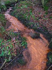
(SNH) organisation. Burns from some of these (Auchentiber, Sidehead and Brummel) run through the hamlet on their way to join the Lugton Water.
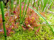
 Typical plants of these mosses are Cottongrasses, Ling Heather, Bell Heather, Cranberry, Blaeberry, Bog Rosemary, Sundews, Deer Grass, Crowberry, etc. Mr. Kerr, the Montgreenan Estate forester in 1915 described to the Kilmarnock Glenfield Ramblers how afforestation was being tried on Auchentiber Moss by his employer, Sir James Bell. During WW1 many woods were cut to provide timber for the war effort and plantings took place to provide for future needs.
The part of Auchentiber Moss that was successfully planted circa 1915 now has a good number of large, uniformly aged Scots Pines that have greatly contributed to the drying out of the moss in those areas. The pines are also successfully spreading out into the open areas of the moss and will eventually degraded the site unless these trees, as well as the Silver Birch, are removed. The North Ayrshire Ranger Service carried out a detailed survey of the Auchentiber and other mosses in 2008.
A certain amount of peat cutting has taken place, especially beside the road to Sevencares and Kilwinning. Historically the Auchentiber and Dykneuk mosses were one continuous moss, as were Bloak and Kennox.
Dr. Duguid visited Bonshaw
, the home of the collector Alexander Reid, circa the 1840s and lists some of the items in Reid's collection, including garden seats made of bog-oak
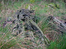
from Auchentiber Moss. In the 1840s during peat cutting at Auchentiber a straight row of wooden stakes was discovered under the peat, which was then between 10 to 12 feet thick.
Image:Auchentiber moss woodland.JPG|Silver birch and Scots pine woodland bordering Auchentiber moss.
Image:Auchentiber moss.JPG|Areas of ground flora are dominated by Polytrichum, the Hair Moss.
Image:Auchentiber mossheads.JPG|Unusual Auchentiber 'mossheads' in this rare lowland raised bog habitat.
Image:Bloak Wood Art.JPG|Environmental Art in Bloak Moss Woods.
 Auchenmade railway station
was nearby and was originally part of the Lanarkshire and Ayrshire Railway
. It opened on 3 September 1888. It closed between 1 January 1917 and 2 March 1919 due to wartime economy, and closed permanently on 4 July 1932.
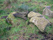
Most milestones are no longer in situ and often the only remaining clue is an otherwise unexplained 'kink' in the line of a hedgerow. The milestones were buried during the Second World War so as not to provide assistance to invading troops, German spies, etc. This seems to have happened all over Scotland, however Fife was more fortunate than Ayrshire, for the stones were taken into storage and put back in place after the war had finished.
 Greenlea, Wardlaw, Law, Redwells, Mid Auchenmade, South Auchenmade, Sunnyside, Sidehead, and Bentfauld farms are in the immediate area.
The name 'Wardlaw' is said to derive from 'Watch Hill' as it has a prominent position and a good view therefore. The satellite views of the area around Auchentiber show up the old rig and furrow
systems of pre-mechanised agriculture.
was making her way to the Blair Tavern to keep a tryst
when she fell into a mine shaft, horse and all, and was killed. Others say that her 'lad' killed her and then jumped into the shaft after her. Her ghost haunts the fields around Auchentiber.
.
are located in the immediate Auchentiber area at co-ordinates which can be found by registering on the Geocaching website. You will really need a GPS device to find it. A Geocache 'Grand Master' dwells at Auchentiber, so you will be in good company.
 In 1507 a nominal fine is next inflicted on a Cuthbert Robisoune, farmer in Auchentiber, for an assault committed on one of his neighbours and upon the son. The latter he had cast into the fire, burning him severely. Fine, five merks.
The old estate of Montgreenan is now a hotel, about 1.2 miles (1.9 km) away towards Torranyard.
The ruin of Auchenharvie Castle
is a prominent feature of this flat landscape in the Torranyard area.
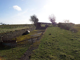
A smithy is marked on the 1860 OS map on the 'hamlet' side of the crossroads and the relatively unchanged building is still present today (2007), the roof has since collapsed (2008). The site of the old hamlet school is now occupied by modern buildings.
Pencot community woodland lies between Auchentiber and Dalry. The trees have grown a fair bit now (2007) and the place has now evolved into a fine location for a walk in the country.
Park at N55,42.299 W004, 39.835 and chose one of the three alternative paths. It doesn't matter which one, as they will all take you there in the end. The middle path will take you via the trig point. A geocache
is located here.
Bloak Moss has been scientifically investigated to ascertain its vegetational history through the analysis of core samples.
Steven states that a 'village' called Bloak with about twelve families existed in 1842, with its own school. It was near the Bloak or salt well.
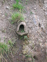
A few springs or 'tibers' are still visible as the source of small burns running into the Glazert beyond Wardlaw farm.
North Ayrshire
North Ayrshire is one of 32 council areas in Scotland with a population of roughly 136,000 people. It is located in the south-west region of Scotland, and borders the areas of Inverclyde to the north, Renfrewshire to the north-east and East Ayrshire and South Ayrshire to the East and South...
, Parish of Kilwinning
Kilwinning
Kilwinning is a historic town in North Ayrshire, Scotland. It is known as The Crossroads of Ayrshire. The 2001 Census recorded it as having a population of 15,908.-History:...
, Scotland. Auchentiber is 4 miles (6.4 km) NE of Kilwinning on the Lochlibo Road, 2.2 miles (3.5 km) from the hamlet of Burnhouse
Barony and Castle of Giffen
The Barony of Giffen and its associated 15th-century castle were in the parish of Beith in the former District of Cunninghame, now North Ayrshire. The site may be spelled Giffen or Giffin and lay within the Lordship of Giffin, which included the Baronies of Giffen, Trearne, Hessilhead, Broadstone,...
and 2.6 miles (4.2 km) from the village of Barrmill
Barony and Castle of Giffen
The Barony of Giffen and its associated 15th-century castle were in the parish of Beith in the former District of Cunninghame, now North Ayrshire. The site may be spelled Giffen or Giffin and lay within the Lordship of Giffin, which included the Baronies of Giffen, Trearne, Hessilhead, Broadstone,...
. Grid Ref. NS3647. Some new housing has been built, but the settlement is still very much a hamlet. The settlement is on the Lugton Water, which runs into the River Garnock
River Garnock
The River Garnock, the smallest of Ayrshire's six principal rivers, has its source on the southerly side of the Hill of Stake in the heart of the Clyde Muirshiel Regional Park. About a mile and a half south of this starting point the untested stream tumbles over the Spout of Garnock, the highest...
after running through Montgreenan
The Lands of Montgreenan
Montgreenan is an estate in North Ayrshire, Parish of Kilwinning, Scotland. The Lugton Water runs through the policies and farmland of Montgreenan...
and Eglinton Country Park
Eglinton Country Park
Eglinton Country Park is located in the grounds of the old Eglinton Castle estate, Kilwinning, North Ayrshire, Scotland . Eglinton Park is situated in the parish of Kilwinning, part of the former district of Cunninghame, and covers an area of 400 hectares...
in Irvine
Irvine, North Ayrshire
Irvine is a new town on the coast of the Firth of Clyde in North Ayrshire, Scotland. According to 2007 population estimates, the town is home to 39,527 inhabitants, making it the biggest settlement in North Ayrshire....
.
Introduction
Auchentiber lies on the old toll roads from Ayr (15 miles) to GlasgowGlasgow
Glasgow is the largest city in Scotland and third most populous in the United Kingdom. The city is situated on the River Clyde in the country's west central lowlands...
(17 miles), and Irvine
Irvine, North Ayrshire
Irvine is a new town on the coast of the Firth of Clyde in North Ayrshire, Scotland. According to 2007 population estimates, the town is home to 39,527 inhabitants, making it the biggest settlement in North Ayrshire....
to Glasgow with a junction for Kilwinning
Kilwinning
Kilwinning is a historic town in North Ayrshire, Scotland. It is known as The Crossroads of Ayrshire. The 2001 Census recorded it as having a population of 15,908.-History:...
and a nearby country road leading to Bloak, Aiket castle, Bonshaw, the Kilbrides and ultimately to Stewarton
Stewarton
Stewarton is a town in East Ayrshire, Scotland. In comparison to the neighbouring towns of Kilmaurs, Fenwick, Dunlop and Lugton, it is a relatively large town, with a population of over 6,500. It is 300 feet above sea level.Groome, Francis H. . Ordnance Gazetteer of Scotland. Pub. Caxton. London....
. The main part of the village is now on a 'cul de sac', however previously lanes, footpaths and fords gave through routes to Fergushill Hall, the Stewarton road and back up to the Glasgow or 'Lochlibo Road' via Bentfauld farm. A lane branches off at Bloak Road Bridge which runs via several farms, past Clonbeith and thence to Irvine via Sevenacres.
History
Spelt 'Auchintibber' in 1879, Ainslie's map of 1822 marks the site of the settlement with the modern spelling of 'Auchentiber'. The name 'Achertybry' is marked on Pont's map of 1604, and another similar name, Achyntybers' is marked in the Parish of Stewarton as part of the 'Barony of Balgray'. The Stewarton area farms of this name are still extant and Pont states that the 'Achin-Tybers' are the inheritance of the Earls of Cassillis. Armstrong's map of 1775, shows Auchentiber, Wardlaw and Redwells. Bloak is spelt 'Bloate'.| Etymology |
| The name Auchentiber, is thought to be derived, according to Pont, from 'the field of the well'. In Gaelic an 'Achin' is a 'fauld' or 'field' created from the clearance of 'wild' land and a 'Tiber' is a well or spring. See Knockentiber Knockentiber Knockentiber is a village in East Ayrshire, Parish of Kilmaurs, Scotland. Knockentiber is WNW of Kilmarnock and 1/2 mile NE of Crosshouse. Latitude:55.6193°N Longitude:4.5455°W and . The population was 359 in 1991, however the population is much higher following the construction of several... . |
In 1550 , Gavin Hamilton of Raploch, Abbot of Kilwinning Abbey granted the lands of 'Auchintiber' and 'Airthmaid' (Auchenmmade) to Gavin of Raploch, at an annual rent of 16 bolls of beir ('Beir', 'Bere' also 'Bear' was the primitive indigenous form of one-sided barley. It gave a good yield on poor soils and its straw, used for thatching, was long and strong), 9 score 18 stones of cheese, and 7 stirks. This continued with Alexander Cunninghame, the commendator of the abbey in 1571 and third son of Alexander, fifth Earl of Glencairn
Earl of Glencairn
The title of Earl of Glencairn was created in the Peerage of Scotland in 1488 for the first Lord Kilmaurs .On the death of the fifteenth earl in 1796, there existing no original Letters Patent of the creation nor a given remainder in the various confirmations in title of previous earls the title...
. He was destined to be shot at his own gate on 1 August 1591 by Sir Robert Montgomerie of Skelmorlie, as part of the reprisals linked to the murder of the Earl of Eglinton
Earl of Eglinton
Earl of Eglinton is a title in the Peerage of Scotland.Some authorities spell the title: Earl of Eglintoun In 1859 the thirteenth Earl of Eglinton, Archibald Montgomerie, was also created Earl of Winton in the Peerage of the United Kingdom, which gave him an automatic seat in the House of Lords,...
, a Montgomery
Clan Montgomery
-Origins of the Clan:Clan Montgomery originated in Wales, and emigrated to Scotland in the 12th century as vassals of the FitzAlans. The family derives its surname from lands in Wales, likely from the Honour of Montgomery which was located near the Shropshire lands of the FitzAlans...
, at the Annick Ford on 18 April 1586.
In June 1590, Andrew Mure is recorded as being the heir to his late father John, in the 10s (Scots) lands of Over-Auchentiber in the Bailiary of Cuninghame, which he holds for the payment of 10 firlots and 2 pecks of oatmeal from the feudal lord. John Dene or Deyne is recorded on the same date as heir to his father John of the 20s (Scots) lands of Over-Auchentiber for 41 stone of cheese (petrae casei
Dunlop cheese
Dunlop is a mild cheese or 'sweet-milk cheese' from Dunlop in East Ayrshire, Scotland. It resembles a soft Cheddar cheese in texture. It fell out of popularity some time after the end of the Second World War, however it has now appreciated for its value in various recipes and for eating on its own...
). On 4 October 1671, Janet and Agnes Murchland, are recorded as heirs of their grandfather, John Murchland in Cavan Miln (mill), in a part of the 40s (Scots) of Nether - Auchentiber.
In 1640 Hew Montgomerie is recorded as owning 'Over-Auchentyber', with John Dean and his mother, Andro (Sic) Mure and Robert Mure residing there. In 1876 the Auchentibers belonged to Robert Bruce Robertson Glasgow of Montgreenan, William Gemmell, Hugh Fleming, and Robert Fleming.
Steven lists John & Alexander Ferguson, Alexander Wylie and Robert Duncan in 1842 as owners of the 'Auchentibers'.
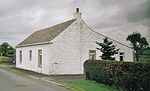
The Cleikum Inn
An Inn with this name is marked on the 1860 OS map on the right hand side of the road near Bentfauld farm. The 1895 does not name it as an inn, but does mark the inn at the position of the present day Blair Tavern; the 1925 OS marks the inn, but not the present day 'Blair Tavern'. The name Cleikum may be related to the 'Cleikum Inn' which features in Sir Walter Scott’s novel 'St Ronan’s Well', in which the 'Cleikum Club' met in the 'Cleikum Inn', so called from the sign-post showing the Saint catching the Devil. Meg Dods, landlady of the Cleikum Inn, is a formidable hostess, who runs a well organised hostelry with high standards of cleanliness and a distinct partiality regarding the social standing of her guests. This may explain why the name was taken up by many inns throughout the country. The name is derived from a unique ceremony the “Cleikum Celebrations.” . . . According to the ancient story, St Ronan met the evil one and “cleekit him” well and truly by the “hint leg” and vanquished him with the only weapon to hand, the Cleikum Crook, a replica of which is carried by the “Patron Saint” during these celebrations at InnerleithenInnerleithen
Innerleithen is a small town in the committee area of Tweeddale, in the Scottish Borders.-Etymology:The name "Innerleithen" comes from the Scottish Gaelic meaning "confluence of the Leithen", because it is here that the river joins the Tweed. The prefix "Inner-/Inver-" is common in many Scottish...
, near Edinburgh. A boy takes the part of the Patron Saint. A 'Cleik' in Scots is a metal pole from which a pot was hung to heat over a fire.
Mistress Dods was the landlady of the Cleikum Inn near Peebles which hosted the gatherings of the Cleikum Club. The aim of the club, which counted Sir Walter Scott among its members, was to celebrate our Scottish national literature. They certainly were among the first organisations to celebrate a Burns' Night. Mistress Dods was a superb cook and rigorous task-master. Staff ' and guests ' trembled before her! Her major publication 'The Cook's and Housewife's Manual' had the same iconic relationship to Scottish cuisine as that of Mrs Beaton to households south of the border. The name of the inn may reflect the popularity of Sir Walter Scott's novels at the time. The inn may have lost out to competition from the 'Blair Tavern' or to Burnhouse
Barony and Castle of Giffen
The Barony of Giffen and its associated 15th-century castle were in the parish of Beith in the former District of Cunninghame, now North Ayrshire. The site may be spelled Giffen or Giffin and lay within the Lordship of Giffin, which included the Baronies of Giffen, Trearne, Hessilhead, Broadstone,...
which had several inns at one time.
James Samuel Wyper was born on 24 October 1920, at Shettleston in Glasgow. When he was two years old he moved with his parents and sisters Violet, Margaret and Tilda to rural Auchentiber near Kilwinning in Ayrshire where their home was a former old coaching inn, the iron rings for tethering horses still embedded in the outer walls. James's sister Margaret remained at the Inn nursing both her parents until their death. She married her husband Duncan Hyslop at the nearby Benslie Parish Church and her daughter Margaret was born in the house. When her brother James sold the house Margaret and her family moved to Uplawmoor. A lay-by now exists at the site of the Cleikum Inn. Disaster befell all occupants of this Inn which is said to have been haunted by William Wallace trying to return to Elderslie. Illnesses, particularly blood disorders, afflicted all who lived in this Inn for any length of time.
The local schools
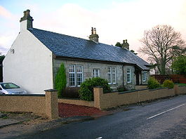
In 1860 a school is shown on the OS map in the hamlet itself, but by 1879 it has moved to the other side of the Lugton Water, with accommodation for 110 children, and an average attendance of 50, with a grant of £45 11s 0d. In 1881 the attendance was 73 pupils. A new Auchentiber school was built near the Bloak Road bridge and closed in the late 1960s. The building survives as a private house.The Blair Tavern
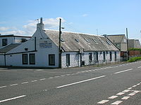
The 'Blair Tavern' is a prominent group of buildings, but it was not opened as a public house until the late 20th century, although the buildings are marked on the 1860 OS map and may be even older. The date 1834 in Roman numerals is above the entrance door of the tavern. In the 1960s it was a garage, the Blair Garage and prior to that it may have had some link with the Fergushill Hall. It was renovated in 2008-2009 and is now known as the 'Blair'.Local names
The main road through the hamlet was not in existence in 1745, but when first built it is recorded as 'Lochlibo Road'. 'Bloak Road Bridge' is the one near the entrance to Greenlea (previously Greenlee). Mosside was the farm near the Glasgow 20 miles (32.2 km) and Irvine 5.25 milestone, now a ruin. Meg'swa's' is Megswells and is on the road to Irvine via ClonbeithChapeltoun
Chapeltoun is an estate on the banks of the Annick Water in East Ayrshire, Scotland. This is a rural area famous for its milk and cheese production and the Ayrshire or Dunlop breed of cattle.-Templeton and the Knights Templar:...
, mentioned in the 'Lady in the Peat' story. 'Todholes' was a ruin as far back as 1860 and lay close to a small quarry on the Auchentiber moss side of the Kilwinning Road. 'Waukmill' was a group of buildings near the ford off the old lane that came out on to the Stewarton road beyond Wardlaw farm. Satellite imagery shows up the course of the old waulkmill lade which came off the Lugton Water to power the waterwheel and returned just below the old ford. Twyford Cottage seems to be named after the ford which lay between it and the road to Wardlaw and Bloak.
Fergushill Hall
A number of properties in the surrounding area have the appellation FergushillFergushill
Fergushill is a small community in North Ayrshire, Parish of Kilwinning, Scotland. The Barony of Fergushill was held by the Fergushill family of that Ilk and the area has a complex history.-The Fergushills of that Ilk:...
, such as at Knockentiber
Knockentiber
Knockentiber is a village in East Ayrshire, Parish of Kilmaurs, Scotland. Knockentiber is WNW of Kilmarnock and 1/2 mile NE of Crosshouse. Latitude:55.6193°N Longitude:4.5455°W and . The population was 359 in 1991, however the population is much higher following the construction of several...
; North & South Fergushills near Eglinton, also Hill and Hall of Fergushill at Auchentiber. A lane ran to Fergushill Hall from the buildings in Auchentiber which now form the Blair Tavern. This lane only exists in part now (2007). Robert Fergushill of Fergushill had a crown charter in 1633 of the lands of Middle Auchentiber. He was the last of the lairds and the Craufurds of Craufurdland appear to have inherited. He had married Marion Porterfield, daughter of Alexander Porterfield younger of that Ilk.
Mineral wells and the source of the Chapel Burn
Paterson (1866) states that there is a mineral spring near Stewarton, called the Bloak Well. Robinson gives the Scot's word 'blout' as meaning the 'eruption of fluid' or a place that is soft or wet. Both meanings would fit in this context. Blout and Bloak are very similar words, with a Bloak Moss not very far.| Etymology |
| The name Auchenmade (previously Achin-Medds), is thought to be derived, according to Pont, from either 'the field of sticks or timber'. In Gaelic this is Achadh-na-maid. Madadh is a wolf, dog or fox and this is another possibility. |
A well recorded as Bloak Well was first discovered in 1800, around 1826 or 1810, by the fact that pigeons from neighbouring parishes flocked here to drink. Mr. Cunningham of Lainshaw built a handsome house over the well in 1833 and appointed a keeper to take care of it as the mineral water was of some value. This is now known at 'Salt Well', lying next to the Glazert.
The Quarries and limekilns
Near Waukmill the 1860 OS shows whinstone, limestone and sandstone quarries and a limekiln. On the Kilwinning road is marked the Ward whinstone quarry. On the lane down to East Auchenmade are other freestone and limestone qaurries and limekilns. Another whinstone quarry and limekiln was on the road up to Wardlaw. Waukmill no longer exists A weir existed on the Lugton Water nearby and this may have been connected with a waulkmillDalgarven Mill
Dalgarven Mill is near Kilwinning, in the Garnock Valley, North Ayrshire, Scotland and it is home to the Museum of Ayrshire Country Life and Costume. The watermill has been completely restored over a number of years and is run by the independent Dalgarven Mill Trust.The village of Dalgarven was...
, one that treated wool to make it suitable for producing cloth for clothing.
Views of Auchenmade claypit and brickworks - 2008
A brickworks was situated at the Auchenmade claypit, close to South Auchenmade farm. It was served by the Caledonian RailwayCaledonian Railway
The Caledonian Railway was a major Scottish railway company. It was formed in the early 19th century and it was absorbed almost a century later into the London, Midland and Scottish Railway, in the 1923 railway grouping, by means of the Railways Act 1921...
line that ran from Glasgow to Ardrossan
Ardrossan
Ardrossan is a town on the North Ayrshire coast in south-western Scotland. The name "Ardrossan" describes its physical position — 'ard' from the Gaelic àird meaning headland, 'ros' a promontory and the diminutive suffix '-an' - headland of the little promontory...
via Lissens. the brickworks is marked on the 1896 OS map
Ordnance Survey
Ordnance Survey , an executive agency and non-ministerial government department of the Government of the United Kingdom, is the national mapping agency for Great Britain, producing maps of Great Britain , and one of the world's largest producers of maps.The name reflects its creation together with...
with its railway siding, however by 1911 the siding is no longer shown and although marked, the brickworks may no longer be working.
The Mosses
Site of Special Scientific Interest
A Site of Special Scientific Interest is a conservation designation denoting a protected area in the United Kingdom. SSSIs are the basic building block of site-based nature conservation legislation and most other legal nature/geological conservation designations in Great Britain are based upon...
(SSSI), protected by the Scottish Natural Heritage
Scottish Natural Heritage
Scottish Natural Heritage is a Scottish public body. It is responsible for Scotland's natural heritage, especially its natural, genetic and scenic diversity. It advises the Scottish Government and acts as a government agent in the delivery of conservation designations, i.e...
(SNH) organisation. Burns from some of these (Auchentiber, Sidehead and Brummel) run through the hamlet on their way to join the Lugton Water.
The part of Auchentiber Moss that was successfully planted circa 1915 now has a good number of large, uniformly aged Scots Pines that have greatly contributed to the drying out of the moss in those areas. The pines are also successfully spreading out into the open areas of the moss and will eventually degraded the site unless these trees, as well as the Silver Birch, are removed. The North Ayrshire Ranger Service carried out a detailed survey of the Auchentiber and other mosses in 2008.
A certain amount of peat cutting has taken place, especially beside the road to Sevencares and Kilwinning. Historically the Auchentiber and Dykneuk mosses were one continuous moss, as were Bloak and Kennox.
Dr. Duguid visited Bonshaw
Barony of Bonshaw
The Barony of Bonshaw, previously known as Bollingshaw, was in the old feudal Baillerie of Cunninghame, near Stewarton in what is now North Ayrshire, Scotland.-The Irvines and Boyds:...
, the home of the collector Alexander Reid, circa the 1840s and lists some of the items in Reid's collection, including garden seats made of bog-oak
Bog oak
Bog-wood, also known as morta is wood from trees that have been buried in peat bogs and preserved from decay by the acidic and anaerobic bog conditions, sometimes for hundreds or even thousands of years. The wood is usually stained brown by tannins dissolved in the acidic water...
from Auchentiber Moss. In the 1840s during peat cutting at Auchentiber a straight row of wooden stakes was discovered under the peat, which was then between 10 to 12 feet thick.
Views in Auchentiber and Bloak Moss
Image:Auchentiber moss woodland.JPG|
Image:Auchentiber moss.JPG|
Image:Auchentiber mossheads.JPG|
Image:Bloak Wood Art.JPG|
The Railway
Auchenmade railway station
Auchenmade railway station was a railway station approximately three miles north-east of Kilwinning, North Ayrshire, Scotland. It served the hamlet of Auchentiber and the surrounding rural area as part of the Lanarkshire and Ayrshire Railway.- History :...
was nearby and was originally part of the Lanarkshire and Ayrshire Railway
Lanarkshire and Ayrshire Railway
The Lanarkshire and Ayrshire Railway was a railway company in Scotland built in the late 19th century that provided services between Ardrossan and Glasgow, with branches to Irvine and Kilbirnie. The line was operated by the Caledonian Railway with an aim to compete with the Glasgow and South...
. It opened on 3 September 1888. It closed between 1 January 1917 and 2 March 1919 due to wartime economy, and closed permanently on 4 July 1932.
The Turnpike
Auchentiber was on a toll road or turnpike; the nearest milestone being at the crossroads and the nearest tolls were at Torranyard and Lugton. The name 'Turnpike' originated from the original 'gate' used being just a simple wooden bar attached at one end to a hinge on the supporting post. The hinge allowed it to 'open' or 'turn' This bar looked like the 'pike' used as a weapon in the army at that time and therefore we get 'turnpike'. The term was also used by the military for barriers set up on roads specifically to prevent the passage of horses. In addition to providing better surfaces and more direct routes, the turnpikes settled the confusion of the different lengths given to miles, which varied from 4,854 to nearly 7000 feet (2,133.6 m). Long miles, short miles, Scotch or Scot's miles (5,928 ft), Irish miles (6,720 ft), etc. all existed. 5280 feet (1,609.3 m) seems to have been an average. Another important point is that when these new toll roads were constructed the Turnpike Trusts went to a great deal of trouble to improve the route of the new road and these changes could be quite considerable as the old roads tended to go from farm to farm, hardly the shortest route. The tolls on roads were abolished in 1878 to be replaced by a road 'assessment', which was taken over by the County Council in 1889.| Etymology |
| Auchenharvie, according to Pont is derived from the 'Low hill or 'Knoppe' in a field of yellow corn. |
Most milestones are no longer in situ and often the only remaining clue is an otherwise unexplained 'kink' in the line of a hedgerow. The milestones were buried during the Second World War so as not to provide assistance to invading troops, German spies, etc. This seems to have happened all over Scotland, however Fife was more fortunate than Ayrshire, for the stones were taken into storage and put back in place after the war had finished.
Farms
The name 'Wardlaw' is said to derive from 'Watch Hill' as it has a prominent position and a good view therefore. The satellite views of the area around Auchentiber show up the old rig and furrow
Rig and furrow
Rig and furrow was a type of cultivation practised in upland areas of the British Isles which differs from the more common ridge and furrow in that it appears to have been created through excavation by spade rather than plough....
systems of pre-mechanised agriculture.
The Ghost of Auchentiber
The 'Leddy o'Clumbeith' is a ghost story told by Dr. Duguid circa 1840 in the 1820s. A servant girl from the farm of ClonbeithChapeltoun
Chapeltoun is an estate on the banks of the Annick Water in East Ayrshire, Scotland. This is a rural area famous for its milk and cheese production and the Ayrshire or Dunlop breed of cattle.-Templeton and the Knights Templar:...
was making her way to the Blair Tavern to keep a tryst
Tryst
Tryst may refer to:*A meeting of two lovers, as in courtship*Tryst , a book by Elswyth Thane*Tryst , a play by Karoline Leach*A nightclub at the Wynn Las Vegas hotel...
when she fell into a mine shaft, horse and all, and was killed. Others say that her 'lad' killed her and then jumped into the shaft after her. Her ghost haunts the fields around Auchentiber.
The Lady in the peat
Dr. Duguid in around the 1840s records that near Clumbeith (Clonbeith) on the way to 'Meg'swa's' he met Pate Glunch cutting peats. Pate was normally a still, dour man, but on this occasion he was highly animated and took the doctor to see the long dead corpse of a 'bonnie lady' lying in a hole in the peat. She was around 18 to 20 years of age, had rosy cheeks, a sweet smile playing around her lips and blonde hair. Her identity was unknown, but a rumour linked her to the family of the Montgreenan estateThe Lands of Montgreenan
Montgreenan is an estate in North Ayrshire, Parish of Kilwinning, Scotland. The Lugton Water runs through the policies and farmland of Montgreenan...
.
The Auchentiber geocaches
Two geocachesGeocaching
Geocaching is an outdoor sporting activity in which the participants use a Global Positioning System receiver or mobile device and other navigational techniques to hide and seek containers, called "geocaches" or "caches", anywhere in the world....
are located in the immediate Auchentiber area at co-ordinates which can be found by registering on the Geocaching website. You will really need a GPS device to find it. A Geocache 'Grand Master' dwells at Auchentiber, so you will be in good company.
Micro history
The old estate of Montgreenan is now a hotel, about 1.2 miles (1.9 km) away towards Torranyard.
The ruin of Auchenharvie Castle
Auchenharvie Castle
Auchenharvie Castle is a ruined castle near Torranyard on the A 736 Glasgow to Irvine road. It lies in North Ayrshire, Scotland.-The Castle:...
is a prominent feature of this flat landscape in the Torranyard area.
A smithy is marked on the 1860 OS map on the 'hamlet' side of the crossroads and the relatively unchanged building is still present today (2007), the roof has since collapsed (2008). The site of the old hamlet school is now occupied by modern buildings.
Pencot community woodland lies between Auchentiber and Dalry. The trees have grown a fair bit now (2007) and the place has now evolved into a fine location for a walk in the country.
Park at N55,42.299 W004, 39.835 and chose one of the three alternative paths. It doesn't matter which one, as they will all take you there in the end. The middle path will take you via the trig point. A geocache
Geocaching
Geocaching is an outdoor sporting activity in which the participants use a Global Positioning System receiver or mobile device and other navigational techniques to hide and seek containers, called "geocaches" or "caches", anywhere in the world....
is located here.
Bloak Moss has been scientifically investigated to ascertain its vegetational history through the analysis of core samples.
Steven states that a 'village' called Bloak with about twelve families existed in 1842, with its own school. It was near the Bloak or salt well.
A few springs or 'tibers' are still visible as the source of small burns running into the Glazert beyond Wardlaw farm.