
The Lands of Montgreenan
Encyclopedia
Montgreenan is an estate in North Ayrshire
, Parish of Kilwinning
, Scotland. The Lugton Water runs through the policies and farmland of Montgreenan. Nearby are the hamlets of Torranyard
and Auchentiber
.
in the period 1604-1608. In it he describes 'Mongrynen Castle' as “…ane old strong Dunijon veil and pleasantly planted ye inheritance of Cuninghame Laird thereof sone to the abott of Kilwinin quho wes brother to James Earle of Glencairne”. The 10 merk land of Montgreenan was held in the 15th century by the Ross family, who had many lands in Ayrshire, such as those of Dunlop
and its castle. The Ross's held their lands as vassals of the De Morvilles
.
Following the murder of James III of Scotland
, Sir John Ross de Montgreenan lost all his lands, only to rapidly return to royal favour under the rule of James IV
and regain the Manor or Barony of Montgreenan. The manor or barony is said to have passed to the Monastery of Kilwinning
and then to Alexander Cunninghame and his wife Jean Blair in 1582 - 83 following the reformation, of which, Alexander had been a prominent supporter. Lady Jean Cunninghame died in 1621, leaving the lands to her son William, and by 1632 Alexander Cunninghame, a grandson of Lady Jean was the owner, succeeded by his son Thomas in 1656. Thomas's son, of the same name, fought at the Battle of Bothwell Bridge and was sentenced to death for his actions. His life was spared, however his lands were forfeited and given to Lieutenant-General Douglas who sold it on to High Stevenson, clerk to the Privy Council
. In 1691 the Hearth Tax records show the mansion house with seven and five other dwellings associated with the 'Lands of Montgreenan'.
 The estate remained with the Stevenson's until 1778, when they sold it to John Bowman of Ashinyards, who in turn sold it to Dr. Robert Glasgow. The doctor married a daughter, Rachel, of John Dunlop of that Ilk, but they had no offspring; he died in 1827. The funeral was famous for the generosity shown to 616 poor people of the parish.
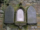
Mrs. Rachel Glasgow was an authoress with great literary taste and she died at Pau, in the Pyrenees
, on 19 July 1828. Mrs Glasgow was commemorated by the erection of a well in Kilwinning's Howgate; she had given £200 to the poor of the town. Robert Robertson of Prenderguest, a son-in-law, inherited the estate, changing his surname to 'Glasgow'. Robert Roberton Glasgow, his son, inherited in 1845 and in 1860 his son, Robert Bruce Robertson Glasgow inherited Montgreenan in his turn. Sir James Bell, Chairman of the G&SWR
from 1915-1920 lived at Montgreenan.
in 1873 R. B. Robertson-Glasgow was Lieutenant-Colonel commanding the 1st Volunteer Battalion, Royal Scots Fusiliers and in 1896, R. P. Robertson-Glasgow was likewise Lieutenant-Colonel commanding the 2nd Volunteer Battalion, Royal Scots Fusiliers.
at Stewarton
in April of that year.
John Smith in 1895 recorded that in the Montgreenan Woods are the remains of a Bishop's Palace, sometimes called a castle, of which little appears to be known. Not far away is part of an ancient gateway, and just South of the house there are the remains of a mound which once contained an ice-house. All that remains at this site is a small piece of wall at the side of the stream, and a slight hollow, partly surrounded by a bank formed by the rubbish of the old walls. Mr R. Glasgow, the proprietor, stated in the 1856 Name Book of the Ordnance Survey that the dwelling probably became disused in 1680, when the last Cunninghame of Montgreenan was forfeited. Much of its remains were removed about 1765 by the previous proprietor, Mr Stevenson, to build a house at Kilwinning.
A visit in 1956 recorded that in the thick vegetation were traces of buildings, enclosed by a wall on the West and South sides. The details were unclear, but the castle plan seemed to be that of a courtyard with internal buildings on all sides except perhaps the East, where there is a wall running along the edge of the Lugton Water. Such a building design with a central courtyard was called a 'Place' or 'Palace' due to its construction, not its size. All the walls were merely heaps of rubble, and the drystone "courtyard" wall seemed to be of later construction than the internal remains, acting as a revetment to the mass of rubble inside. This wall was 1.4m high. No clear evidence was encountered for this being a "Bishop's Palace".
About 65.0m to the South was a mound, 1.5m high, which had been cut through by a track, and may be the ice-house referred to by Smith, although no stone-work exists. No trace of a gateway was found, although the possible entrance shown on OS plan
may be the gateway referred to.
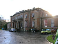
The present Georgian mansion with architectural features by Alexander 'Greek' Thompson was built by Sir Robert Glasgow in 1817. Sir Robert, in common with other entrepreneurs from the Glasgow area, made his fortune through a shipping company based in St Vincent
in the West Indies, undoubtedly trading between Britain, Africa and the sugar plantations of the West Indies. Montgreenan mansion house was a private dwelling until 1982, since when it has been a hotel. The building is Category A listed by Historic Scotland.
Alexander Craufurd of Fergushill
inherited Fergushill from his father and it next passed by inheritance to the Kincaid family who alienated the lands to Neil Macvicar and his wife Elizabeth Montgomerie in 1728. The Macvicars retained the lands until 1802 when they were acquired by Robert Glasgow of Montgreenan. Archibald Stevenson acquired Montgreenan in 1755 and sold it to Mr. Bowman in 1778, a Provost of Glasgow and builder of Ashgrove House
at Ashinyards near Kilwinning.
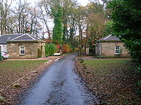
The estate had a curling pond, a fine stable block, offices, a mains farm and a walled garden. The buildings still survive as private dwellings (2008). Caven Mill is likely to have been the barony mill to which the tenants were thirled
; this building is now a ruin.
 The 1858 OS
map shows a carriage or driveway running from close to the surviving Auchentiber schoolhouse on the Lochlibo road, passed the old Murchland farm site (Murghland in 1747. Murchen is the Scots
for a hare
.) through the Montgreenan plantations, crossing the road near Cavan Mill and finally running on down to Montgreenan house. A track and later a road ran from Auchenharvie Castle
across the Lochlibo toll road and up to Megswells (Meggs Walls in 1747), crossing the Lugton Water by stepping stones and later by a ford. This route ran under the aforementioned Montgreenan carriageway via a bridge which has an embankment leading up to it. The area near the old Mosside farm has been the site of several limestone quarries and limekilns in 1858 (OS
), but by 1897 these had closed.
Mosside bridge is of a very high quality of workmanship and ornamentation. It has false windows, diamond / lozenge
shaped embellishments, a thistle on the keystones and raised random patterns and other designs which represent leaves.
The Ness Papers state that the false windows were for the insertion of a coat of arms and that the old coach road ran across this bridge on its way to Cavan Mill and beyond.
 The Glasgow and South Western Railway
built a station at Montgreenan
which opened on 1 February 1878, and closed permanently to passengers on 7 March 1955,. The station building is now a private residence. The house near the old entrance was the manse for the old Fergushill church at Benslie at one point and was previously used by the railway as a dwelling for their agent.
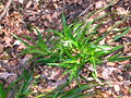 The Old Wood in particular has a high biodiversity, some of the species noted in 2007 being
Woodruff, Bird cherry, Primrose, Common violet, Oak, Stitchwort, Opposite-leaved Golden saxifrage, Bluebell, Greater Woodrush, Dog's mercury, Broad buckler fern, Lord and Ladies, Lady fern, Male shield fern, Easter ledges, Wood-rush, Wood-sedge, blackthorn, hawthorn, elm, alder, Wood anemone, Wood sorrel, Wood avens, Herb Robert, Red campion, and many liverworts. A number of badger setts are present.
was found at Montgreenan circa 1740 by the laird, consisting of seven crocks of coins, rings, brooches, candlesticks, crosses, necklasses, pomanders, beads, etc. A local legend was that Alexander Cunninghame, the commendator of the abbey and living at Montgreenan had buried the abbey treasure, knowing that his life was in danger following the murder of the 4th Earl of Eglinton. He was murdered at the entrance to his home in 1586 and his ghost was said to protect the treasure.
John Smith in 1895 recorded that a pot of silver coins was found in the Chapel Park, on Montgreenan lands (NS 343 445). The existence of a pre-reformation chapel is not recorded other than this field name record.
village was named 'Montgreenan' up until at least 1938, with the name Benslie given to the wood, the old farmhouse on the 'island' created by the three roads and the term Benslie Square. The postal address may have been the direct cause of the name change, preventing confusion with the Montgreenan estate.
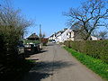
 Opposite Janburrow in Benslie is Burnbrae cottage, built as the Montgreenan Estate factor's house in 1846. Adjacent to Burnbrae is Burnbank Cottage which was built in 1882 for Mathew Kirkland, a former gamekeeper on the Eglinton estate. Burnbrae appears on General Roy's 18th century map and Aitkens map of 1828.
The ruin of Auchenharvie Castle
is a prominent feature of this flat landscape in the Torranyard area.
Bloak Moss has been scientifically investigated to ascertain its vegetational history through the analysis of core samples.
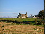
South Fergushill church in Benslie was built to serve Montgreenan, Fergushill
, Doura and Benslie
. It was consecrated on Sunday, 3 November 1879 and the first minister was then Rev. William McAlpine.
The Montgreenan coal mine was served by the railway that ran up via Sevenacres. It was abandoned prior to 1875.
North Ayrshire
North Ayrshire is one of 32 council areas in Scotland with a population of roughly 136,000 people. It is located in the south-west region of Scotland, and borders the areas of Inverclyde to the north, Renfrewshire to the north-east and East Ayrshire and South Ayrshire to the East and South...
, Parish of Kilwinning
Kilwinning
Kilwinning is a historic town in North Ayrshire, Scotland. It is known as The Crossroads of Ayrshire. The 2001 Census recorded it as having a population of 15,908.-History:...
, Scotland. The Lugton Water runs through the policies and farmland of Montgreenan. Nearby are the hamlets of Torranyard
Auchenharvie Castle
Auchenharvie Castle is a ruined castle near Torranyard on the A 736 Glasgow to Irvine road. It lies in North Ayrshire, Scotland.-The Castle:...
and Auchentiber
Auchentiber
The hamlet of Auchentiber is in North Ayrshire, Parish of Kilwinning, Scotland. Auchentiber is NE of Kilwinning on the Lochlibo Road, from the hamlet of Burnhouse and from the village of Barrmill. Grid Ref. NS3647. Some new housing has been built, but the settlement is still very much a hamlet...
.
The Lands of Montgreenan
The name 'Grenane' is recorded in 1480, however the first detailed reference to Montgreenan is contained in the description of the ancient county of Cuninghame by Timothy PontTimothy Pont
Timothy Pont was a Scottish topographer, the first to produce a detailed map of Scotland. Pont's maps are among the earliest surviving to show a European country in minute detail, from an actual survey.-Life:...
in the period 1604-1608. In it he describes 'Mongrynen Castle' as “…ane old strong Dunijon veil and pleasantly planted ye inheritance of Cuninghame Laird thereof sone to the abott of Kilwinin quho wes brother to James Earle of Glencairne”. The 10 merk land of Montgreenan was held in the 15th century by the Ross family, who had many lands in Ayrshire, such as those of Dunlop
Dunlop, East Ayrshire
Dunlop is a village and parish in East Ayrshire, Scotland. It lies on the A735, north-east of Stewarton, seven miles from Kilmarnock. The road runs on to Lugton and the B706 enters the village from Beith.-The village:...
and its castle. The Ross's held their lands as vassals of the De Morvilles
Lambroughton
Lambroughton is a village in the old Barony of Kilmaurs, North Ayrshire, Scotland. This is a rural area famous for its milk and cheese production and the Ayrshire or Dunlop breed of cattle.-Origins of the name:...
.
| Etymology |
| Montgreenan means 'Mound of the Sun' / 'Sunny Mound'. or 'Hill of the Hall or Palace.' |
Following the murder of James III of Scotland
James III of Scotland
James III was King of Scots from 1460 to 1488. James was an unpopular and ineffective monarch owing to an unwillingness to administer justice fairly, a policy of pursuing alliance with the Kingdom of England, and a disastrous relationship with nearly all his extended family.His reputation as the...
, Sir John Ross de Montgreenan lost all his lands, only to rapidly return to royal favour under the rule of James IV
James IV of Scotland
James IV was King of Scots from 11 June 1488 to his death. He is generally regarded as the most successful of the Stewart monarchs of Scotland, but his reign ended with the disastrous defeat at the Battle of Flodden Field, where he became the last monarch from not only Scotland, but also from all...
and regain the Manor or Barony of Montgreenan. The manor or barony is said to have passed to the Monastery of Kilwinning
Kilwinning
Kilwinning is a historic town in North Ayrshire, Scotland. It is known as The Crossroads of Ayrshire. The 2001 Census recorded it as having a population of 15,908.-History:...
and then to Alexander Cunninghame and his wife Jean Blair in 1582 - 83 following the reformation, of which, Alexander had been a prominent supporter. Lady Jean Cunninghame died in 1621, leaving the lands to her son William, and by 1632 Alexander Cunninghame, a grandson of Lady Jean was the owner, succeeded by his son Thomas in 1656. Thomas's son, of the same name, fought at the Battle of Bothwell Bridge and was sentenced to death for his actions. His life was spared, however his lands were forfeited and given to Lieutenant-General Douglas who sold it on to High Stevenson, clerk to the Privy Council
Privy council
A privy council is a body that advises the head of state of a nation, typically, but not always, in the context of a monarchic government. The word "privy" means "private" or "secret"; thus, a privy council was originally a committee of the monarch's closest advisors to give confidential advice on...
. In 1691 the Hearth Tax records show the mansion house with seven and five other dwellings associated with the 'Lands of Montgreenan'.
Mrs. Rachel Glasgow was an authoress with great literary taste and she died at Pau, in the Pyrenees
Pyrenees
The Pyrenees is a range of mountains in southwest Europe that forms a natural border between France and Spain...
, on 19 July 1828. Mrs Glasgow was commemorated by the erection of a well in Kilwinning's Howgate; she had given £200 to the poor of the town. Robert Robertson of Prenderguest, a son-in-law, inherited the estate, changing his surname to 'Glasgow'. Robert Roberton Glasgow, his son, inherited in 1845 and in 1860 his son, Robert Bruce Robertson Glasgow inherited Montgreenan in his turn. Sir James Bell, Chairman of the G&SWR
Glasgow and South Western Railway
The Glasgow and South Western Railway , one of the pre-grouping railway companies, served a triangular area of south-west Scotland, between Glasgow, Stranraer and Carlisle...
from 1915-1920 lived at Montgreenan.
in 1873 R. B. Robertson-Glasgow was Lieutenant-Colonel commanding the 1st Volunteer Battalion, Royal Scots Fusiliers and in 1896, R. P. Robertson-Glasgow was likewise Lieutenant-Colonel commanding the 2nd Volunteer Battalion, Royal Scots Fusiliers.
The Castle or Bishop's Palace
The ruins of the old Montgreenan Castle or Bishop's Palace lie in a loop of the Lugton Water at the its confluence with the Cowlinn Burn. The name Dunach Brae for the strip of woodlands nearby, suggests that a hillfort or 'Dun' may have been in the vicinity at a much earlier date. Alexander Cunninghame, the Commendator of Kilwinning Abbey, was shot at his gate at Montgreenan by Sir Robert Montgomerie of Skelmorlie on August 1, 1586, as a direct result of the assassination of the Fourth Earl of EglintonEarl of Eglinton
Earl of Eglinton is a title in the Peerage of Scotland.Some authorities spell the title: Earl of Eglintoun In 1859 the thirteenth Earl of Eglinton, Archibald Montgomerie, was also created Earl of Winton in the Peerage of the United Kingdom, which gave him an automatic seat in the House of Lords,...
at Stewarton
Stewarton
Stewarton is a town in East Ayrshire, Scotland. In comparison to the neighbouring towns of Kilmaurs, Fenwick, Dunlop and Lugton, it is a relatively large town, with a population of over 6,500. It is 300 feet above sea level.Groome, Francis H. . Ordnance Gazetteer of Scotland. Pub. Caxton. London....
in April of that year.
John Smith in 1895 recorded that in the Montgreenan Woods are the remains of a Bishop's Palace, sometimes called a castle, of which little appears to be known. Not far away is part of an ancient gateway, and just South of the house there are the remains of a mound which once contained an ice-house. All that remains at this site is a small piece of wall at the side of the stream, and a slight hollow, partly surrounded by a bank formed by the rubbish of the old walls. Mr R. Glasgow, the proprietor, stated in the 1856 Name Book of the Ordnance Survey that the dwelling probably became disused in 1680, when the last Cunninghame of Montgreenan was forfeited. Much of its remains were removed about 1765 by the previous proprietor, Mr Stevenson, to build a house at Kilwinning.
A visit in 1956 recorded that in the thick vegetation were traces of buildings, enclosed by a wall on the West and South sides. The details were unclear, but the castle plan seemed to be that of a courtyard with internal buildings on all sides except perhaps the East, where there is a wall running along the edge of the Lugton Water. Such a building design with a central courtyard was called a 'Place' or 'Palace' due to its construction, not its size. All the walls were merely heaps of rubble, and the drystone "courtyard" wall seemed to be of later construction than the internal remains, acting as a revetment to the mass of rubble inside. This wall was 1.4m high. No clear evidence was encountered for this being a "Bishop's Palace".
About 65.0m to the South was a mound, 1.5m high, which had been cut through by a track, and may be the ice-house referred to by Smith, although no stone-work exists. No trace of a gateway was found, although the possible entrance shown on OS plan
Ordnance Survey
Ordnance Survey , an executive agency and non-ministerial government department of the Government of the United Kingdom, is the national mapping agency for Great Britain, producing maps of Great Britain , and one of the world's largest producers of maps.The name reflects its creation together with...
may be the gateway referred to.
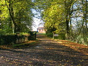
The Mansion House and estate
The present Georgian mansion with architectural features by Alexander 'Greek' Thompson was built by Sir Robert Glasgow in 1817. Sir Robert, in common with other entrepreneurs from the Glasgow area, made his fortune through a shipping company based in St Vincent
Saint Vincent (island)
Saint Vincent is a volcanic island in the Caribbean. It is the largest island of the chain called Saint Vincent and the Grenadines. It is located in the Caribbean Sea, between Saint Lucia and Grenada. It is composed of partially submerged volcanic mountains...
in the West Indies, undoubtedly trading between Britain, Africa and the sugar plantations of the West Indies. Montgreenan mansion house was a private dwelling until 1982, since when it has been a hotel. The building is Category A listed by Historic Scotland.
Alexander Craufurd of Fergushill
Fergushill
Fergushill is a small community in North Ayrshire, Parish of Kilwinning, Scotland. The Barony of Fergushill was held by the Fergushill family of that Ilk and the area has a complex history.-The Fergushills of that Ilk:...
inherited Fergushill from his father and it next passed by inheritance to the Kincaid family who alienated the lands to Neil Macvicar and his wife Elizabeth Montgomerie in 1728. The Macvicars retained the lands until 1802 when they were acquired by Robert Glasgow of Montgreenan. Archibald Stevenson acquired Montgreenan in 1755 and sold it to Mr. Bowman in 1778, a Provost of Glasgow and builder of Ashgrove House
The Lands of Ashgrove
The Lands of Ashgrove, previously known as Ashenyards formed a small estate in the Parish of Kilwinning, North Ayrshire lying between Kilwinning and Stevenston...
at Ashinyards near Kilwinning.
The estate had a curling pond, a fine stable block, offices, a mains farm and a walled garden. The buildings still survive as private dwellings (2008). Caven Mill is likely to have been the barony mill to which the tenants were thirled
Thirlage
Thirlage was the term used for the law in regard of the milling of grain for personal or other uses. Vassals in a feudal barony were thirled to their local mill owned by the feudal superior...
; this building is now a ruin.
The Montgreenan milestones
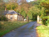
Beside the driveways running to the Montgreenan mansion house from the Lodges are a number of red sandstone pillars, these are milestones. They look like gatepost-like and were 'rescued' after they became redundant or 'in the way' as a result of road widening works, etc. They have been brought from various places in Ayrshire. Sir James Bell of Montgreenan had a hobby of collecting milestones and other stones. Many Ayrshire milestones were buried during the Second World War as an invasion precaution. Two are near the West Lodge and three of these milestones are near the East Lodge at Montgreenan Mains.The Montgreenan to Auchentiber carriageway
Ordnance Survey
Ordnance Survey , an executive agency and non-ministerial government department of the Government of the United Kingdom, is the national mapping agency for Great Britain, producing maps of Great Britain , and one of the world's largest producers of maps.The name reflects its creation together with...
map shows a carriage or driveway running from close to the surviving Auchentiber schoolhouse on the Lochlibo road, passed the old Murchland farm site (Murghland in 1747. Murchen is the Scots
Scots language
Scots is the Germanic language variety spoken in Lowland Scotland and parts of Ulster . It is sometimes called Lowland Scots to distinguish it from Scottish Gaelic, the Celtic language variety spoken in most of the western Highlands and in the Hebrides.Since there are no universally accepted...
for a hare
Hare
Hares and jackrabbits are leporids belonging to the genus Lepus. Hares less than one year old are called leverets. Four species commonly known as types of hare are classified outside of Lepus: the hispid hare , and three species known as red rock hares .Hares are very fast-moving...
.) through the Montgreenan plantations, crossing the road near Cavan Mill and finally running on down to Montgreenan house. A track and later a road ran from Auchenharvie Castle
Auchenharvie Castle
Auchenharvie Castle is a ruined castle near Torranyard on the A 736 Glasgow to Irvine road. It lies in North Ayrshire, Scotland.-The Castle:...
across the Lochlibo toll road and up to Megswells (Meggs Walls in 1747), crossing the Lugton Water by stepping stones and later by a ford. This route ran under the aforementioned Montgreenan carriageway via a bridge which has an embankment leading up to it. The area near the old Mosside farm has been the site of several limestone quarries and limekilns in 1858 (OS
Ordnance Survey
Ordnance Survey , an executive agency and non-ministerial government department of the Government of the United Kingdom, is the national mapping agency for Great Britain, producing maps of Great Britain , and one of the world's largest producers of maps.The name reflects its creation together with...
), but by 1897 these had closed.
Mosside bridge is of a very high quality of workmanship and ornamentation. It has false windows, diamond / lozenge
Lozenge
A lozenge , often referred to as a diamond, is a form of rhombus. The definition of lozenge is not strictly fixed, and it is sometimes used simply as a synonym for rhombus. Most often, though, lozenge refers to a thin rhombus—a rhombus with acute angles of 45°...
shaped embellishments, a thistle on the keystones and raised random patterns and other designs which represent leaves.
The Ness Papers state that the false windows were for the insertion of a coat of arms and that the old coach road ran across this bridge on its way to Cavan Mill and beyond.
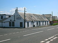
Montgreenan railway station
Glasgow and South Western Railway
The Glasgow and South Western Railway , one of the pre-grouping railway companies, served a triangular area of south-west Scotland, between Glasgow, Stranraer and Carlisle...
built a station at Montgreenan
Montgreenan railway station
Montgreenan railway station was a railway station near the village of Benslie, three miles north east of the town of Kilwinning, North Ayrshire, Scotland...
which opened on 1 February 1878, and closed permanently to passengers on 7 March 1955,. The station building is now a private residence. The house near the old entrance was the manse for the old Fergushill church at Benslie at one point and was previously used by the railway as a dwelling for their agent.
The Lady in the peat
Dr. Duguid in around the 1840s records that near Clumbeith (Clonbeith) on the way to 'Meg'swa's' he met Pate Glunch cutting peats. Pate was normally a still, dour man, but on this occasion he was highly animated and took the doctor to see the long dead corpse of a 'bonnie lady' lying in a hole in the peat. She was around 18 to 20 years of age, had rosy cheeks, a sweet smile playing around her lips and blonde hair. Her identity was unknown, but a rumour linked her to the family of the Montgreenan estate.Natural history
Woodruff, Bird cherry, Primrose, Common violet, Oak, Stitchwort, Opposite-leaved Golden saxifrage, Bluebell, Greater Woodrush, Dog's mercury, Broad buckler fern, Lord and Ladies, Lady fern, Male shield fern, Easter ledges, Wood-rush, Wood-sedge, blackthorn, hawthorn, elm, alder, Wood anemone, Wood sorrel, Wood avens, Herb Robert, Red campion, and many liverworts. A number of badger setts are present.
Legends and archaeology
It is said that a large part of the monks treasure from Kilwinning AbbeyKilwinning Abbey
Kilwinning Abbey is a ruined abbey located in the centre of the town of Kilwinning, North Ayrshire.-The establishment of the Abbey:The ancient name of the town is 'Segdoune' or 'Saigtown', probably derived from 'Sanctoun', meaning the 'town of the saint'. Saint Winnings festival was on 21 January...
was found at Montgreenan circa 1740 by the laird, consisting of seven crocks of coins, rings, brooches, candlesticks, crosses, necklasses, pomanders, beads, etc. A local legend was that Alexander Cunninghame, the commendator of the abbey and living at Montgreenan had buried the abbey treasure, knowing that his life was in danger following the murder of the 4th Earl of Eglinton. He was murdered at the entrance to his home in 1586 and his ghost was said to protect the treasure.
John Smith in 1895 recorded that a pot of silver coins was found in the Chapel Park, on Montgreenan lands (NS 343 445). The existence of a pre-reformation chapel is not recorded other than this field name record.
Micro history
The OS maps show that BenslieBenslie
Benslie is a small village in North Ayrshire, in the parish of Kilwinning, Scotland. Map reference NS 336 429.- History :This village, previously Benislay , Beinslay , Bainsley in 1821 , Bensley , Benslee or Benslee square on the 1860 OS map, Bendslee is situated next to Benslie wood...
village was named 'Montgreenan' up until at least 1938, with the name Benslie given to the wood, the old farmhouse on the 'island' created by the three roads and the term Benslie Square. The postal address may have been the direct cause of the name change, preventing confusion with the Montgreenan estate.
The ruin of Auchenharvie Castle
Auchenharvie Castle
Auchenharvie Castle is a ruined castle near Torranyard on the A 736 Glasgow to Irvine road. It lies in North Ayrshire, Scotland.-The Castle:...
is a prominent feature of this flat landscape in the Torranyard area.
Bloak Moss has been scientifically investigated to ascertain its vegetational history through the analysis of core samples.
South Fergushill church in Benslie was built to serve Montgreenan, Fergushill
Fergushill
Fergushill is a small community in North Ayrshire, Parish of Kilwinning, Scotland. The Barony of Fergushill was held by the Fergushill family of that Ilk and the area has a complex history.-The Fergushills of that Ilk:...
, Doura and Benslie
Benslie
Benslie is a small village in North Ayrshire, in the parish of Kilwinning, Scotland. Map reference NS 336 429.- History :This village, previously Benislay , Beinslay , Bainsley in 1821 , Bensley , Benslee or Benslee square on the 1860 OS map, Bendslee is situated next to Benslie wood...
. It was consecrated on Sunday, 3 November 1879 and the first minister was then Rev. William McAlpine.
The Montgreenan coal mine was served by the railway that ran up via Sevenacres. It was abandoned prior to 1875.
Sources
- Mines Department (1931). Catalogue of Plans of Abandoned Mines. London : HMSO.
- Service, John (1913). The Memorables of Robin Cummell. Paisley : Alexander Gardner.
- Service, John (1890). Thir Notandums, being the literary recreations of the Laird Canticarl of Mongrynen. Edinburgh : Y. J. Pentland.
See also
- River IrvineRiver IrvineThe River Irvine is a river flowing through southwest Scotland, with its watershed on the Lanarkshire border of Ayrshire at an altitude of above sea-level, near Drumclog, and SW by W of Strathaven...
- Eglinton Country ParkEglinton Country ParkEglinton Country Park is located in the grounds of the old Eglinton Castle estate, Kilwinning, North Ayrshire, Scotland . Eglinton Park is situated in the parish of Kilwinning, part of the former district of Cunninghame, and covers an area of 400 hectares...
- AuchentiberAuchentiberThe hamlet of Auchentiber is in North Ayrshire, Parish of Kilwinning, Scotland. Auchentiber is NE of Kilwinning on the Lochlibo Road, from the hamlet of Burnhouse and from the village of Barrmill. Grid Ref. NS3647. Some new housing has been built, but the settlement is still very much a hamlet...
- William Weir, 1st Viscount Weir Previous owners