
River Garnock
Encyclopedia
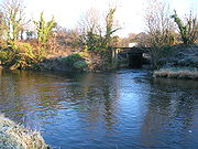
The River Garnock, the smallest of Ayrshire
's six principal rivers, has its source on the southerly side of the Hill of Stake in the heart of the Clyde Muirshiel Regional Park
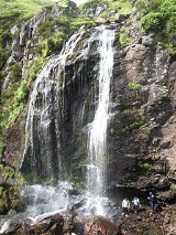
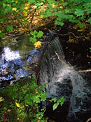
. About a mile and a half south of this starting point the untested stream tumbles over the Spout of Garnock
, the highest waterfall in Ayrshire, once thought to be the river's origin. The river then continues, for a total length of 20 miles (32.2 km) or so, through the towns of Kilbirnie
, Glengarnock
, Dalry and Kilwinning
to its confluence with the River Irvine
at Irvine
Harbour.
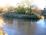
Main tributaries are the Rye Water and Caaf Water which join north and south of Dalry respectively and the Lugton Water which joins just south of Kilwinning.
Garnock" pertains specifically to the short, sometimes precipitous, section of ravine overlooked by the ruins of Glengarnock Castle
north of Kilbirnie, whereas "The Garnock Valley
" refers to a wider geographic area of North Ayrshire
abutting Renfrewshire
, which encompassees the former parishes of Beith
, Dalry, and Kilbirnie
.
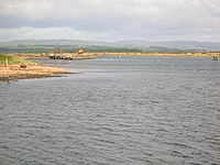
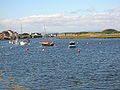 Within Ayrshire by far the largest estuary
has developed, behind the Ardeer Peninsula, at the confluence of the Irvine and Garnock Rivers. This is one of the best examples of a bar-built estuary in the UK and is the only major estuary between the Solway
and Inner Clyde
. The majority of the estuary has been designated a SSSI, in recognition of its national importance for three bird species (eider, red-breasted merganser and goldeneye). It is also a nationally important feeding ground for thousands of migrating birds during the spring and autumn. Otters and water voles live on the estuary as well as numerous breeding birds, including water rail, grasshopper warbler and sand martin. The Garnock/Irvine estuary is also a Wildlife Site.
Bogside Flats SSSI covers 253.8ha that include inter-tidal mudflats, salt-marsh and adjacent pasture land.
The Pundeavon Burn drains from Pundeavon Reservoir and enters the Garnock just upstream of Kilbirnie Cross.
The Paduff Burn is a small stream, known locally as Jock's Burn, which comes into play on the golf course at Kilbirnie Place Golf Club:
The Powgree Burn rises on Cuff hill in the Gateside
area, runs east of the old Speir's school
, through Auchengree
and Longbar
then shortly after runs under Glengarnock railway station
.
The Pitcon Burn cuts deep into the hillside causing the tree lined gully known as Swinlees Glen, a Nature Conservation Site, and enters the Garnock near its namesake Pitcon House.
The Rye Water drains from the area of Muirhead Reservoir and Camphill Reservoir and runs through Drakemyre to join the Garnock north of Dalry near Brownhill Junction on the main railway line
.
 The Putyan Burn forms from a number of small burns, etc., such as the Baidland Burn from Baidland Hill and springs at Baidland Mill. It reaches its confluence with the Garnock at Putyan Cottage and the Lynn Holm, near the road junnction for Ardrossan at the Kilwinning end of the town. It passes Broadlie House where a small weir or dam still exists as part of an abandoned 1892 hydroelectric scheme which provided the house with its own electricity.
The Caaf Water drains from Caaf Reservoir and soon passes the Michelin star rated Braidwoods Restaurant, housed in two simple cottages in the midst of a distinctly rural setting, before entering the Lynn Glen with its picturesque waterfall and finally enters the Garnock south of Dalry.
The Bombo Burn is a small stream, only about 5 miles (8 km) in length, that runs across the north side of Bankhead Moss, a Special Area of Conservation and joins the Garnock soon after passing through the Blair Estate:
 The Dusk Water is a stream that has its beginnings on Cuff Hill, near Beith
, and runs through Barrmill
to eventually join the Garnock upstream of Dalgarven
.
Interesting places along its course, as well as several old watermills, are Giffin House, a large and handsome mansion-house, and Cleeves Cove
, a system of caves in the Dusk Glen.
The Lugton Water, the largest tributary of the Garnock, runs 14 miles (22.5 km) from Loch Libo (395 feet above sea-level) in Uplawmoor
, through Lugton
and the parishes of Neilston, Beith, Dunlop, Stewarton and Kilwinning. The Lugton joins the Garnock below the tidal limit, shortly after passing through Eglinton Country Park
, developed around the ancient estate of the Earl of Eglinton.
The two main rivers of North Ayrshire, the Irvine and the Garnock, come together in the estuary at Irvine Harbour where they jointly enter the Firth of Clyde
.
Major tributaries of the Irvine are the Glen Water, Cessnock Water, Kilmarnock Water (combined Fenwick and Craufurdland Waters), Carmel Water and Annick Water..
Archibald William, the enterprising 13th Earl of Eglinton
purchased all the lands concerned in 1852 and through the simple expedient of cutting a short canal at Bogend, across the loop of the river involved, he bypassed the breach and once the river course had been drained and sealed off he was able to have the flooded mineworkings pumped out. The breach lay on the sea side of the loop close to Bogend on the Snodgrass Holm side. The Earl leased the mines to Bairds of Gartsherrie and the "Eglinton Iron Works" were born.
sending his monks to fish in the Garnock, however no matter how hard they tried or how long they persevered they could catch nothing. The saint in response placed a curse on the river, preventing it from ever having fish in its waters; the river responded by changing course and thereby avoiding the curse. It is clear that the river has substantially changed its course in recorded history, previously having entered the sea at Stevenston. Ardeer therefore being an island at that time. Blaeu's map printed in 1654 shows this.
It was also noted during the construction of a canal serving early coal pits at Ardeer that the small lochans used to ease construction lay on the old course of the River Garnock.
Ayrshire
Ayrshire is a registration county, and former administrative county in south-west Scotland, United Kingdom, located on the shores of the Firth of Clyde. Its principal towns include Ayr, Kilmarnock and Irvine. The town of Troon on the coast has hosted the British Open Golf Championship twice in the...
's six principal rivers, has its source on the southerly side of the Hill of Stake in the heart of the Clyde Muirshiel Regional Park
Clyde Muirshiel Regional Park
Clyde Muirshiel Regional Park is the collective name for areas of countryside set aside for conservation and recreation on the South Clyde estuary in Scotland....
. About a mile and a half south of this starting point the untested stream tumbles over the Spout of Garnock
Spout of Garnock
Ayrshire's highest waterfall , The Spout of Garnock or Garnock Spout , tumbles noisily over a rocky and a somewhat steep downward slope, forming a wild and lonely furious rush of water which is particularly impressive when in spate. It is not the source of the River Garnock, as is sometimes said,...
, the highest waterfall in Ayrshire, once thought to be the river's origin. The river then continues, for a total length of 20 miles (32.2 km) or so, through the towns of Kilbirnie
Kilbirnie
Kilbirnie is a small town of 7280 inhabitants situated in North Ayrshire on the west coast of Scotland...
, Glengarnock
Glengarnock
Glengarnock is a small village in North Ayrshire that lies near the west coast of Scotland. It forms part of the Garnock Valley area and is approximately 25 miles away for Glasgow, the nearest city...
, Dalry and Kilwinning
Kilwinning
Kilwinning is a historic town in North Ayrshire, Scotland. It is known as The Crossroads of Ayrshire. The 2001 Census recorded it as having a population of 15,908.-History:...
to its confluence with the River Irvine
River Irvine
The River Irvine is a river flowing through southwest Scotland, with its watershed on the Lanarkshire border of Ayrshire at an altitude of above sea-level, near Drumclog, and SW by W of Strathaven...
at Irvine
Irvine, North Ayrshire
Irvine is a new town on the coast of the Firth of Clyde in North Ayrshire, Scotland. According to 2007 population estimates, the town is home to 39,527 inhabitants, making it the biggest settlement in North Ayrshire....
Harbour.
Main tributaries are the Rye Water and Caaf Water which join north and south of Dalry respectively and the Lugton Water which joins just south of Kilwinning.
Garnock Valley
"GlenGlen
A glen is a valley, typically one that is long, deep, and often glacially U-shaped; or one with a watercourse running through such a valley. Whittow defines it as a "Scottish term for a deep valley in the Highlands" that is "narrower than a strath."...
Garnock" pertains specifically to the short, sometimes precipitous, section of ravine overlooked by the ruins of Glengarnock Castle
Glengarnock Castle
Glengarnock Castle is one of the ancient ruined fortifications of Ayrshire. Its keep is located on a remote rocky promontory overlooking the River Garnock about north of the town of Kilbirnie in North Ayrshire, Scotland. There is no clear account of when this was erected or by whom, but it may...
north of Kilbirnie, whereas "The Garnock Valley
Garnock Valley
The Garnock Valley is an area in the northern part of North Ayrshire, Scotland, adjoining Renfrewshire.The region includes the towns of Beith, Dalry, and Kilbirnie, and some smaller villages such as Gateside, Barrmill, Longbar and Glengarnock....
" refers to a wider geographic area of North Ayrshire
North Ayrshire
North Ayrshire is one of 32 council areas in Scotland with a population of roughly 136,000 people. It is located in the south-west region of Scotland, and borders the areas of Inverclyde to the north, Renfrewshire to the north-east and East Ayrshire and South Ayrshire to the East and South...
abutting Renfrewshire
Renfrewshire
Renfrewshire is one of 32 council areas used for local government in Scotland. Located in the west central Lowlands, it is one of three council areas contained within the boundaries of the historic county of Renfrewshire, the others being Inverclyde to the west and East Renfrewshire to the east...
, which encompassees the former parishes of Beith
Beith
Beith is a small town situated in the Garnock Valley in North Ayrshire, Scotland approximately 20-miles south-west of Glasgow. The town is situated on the crest of a hill and was known originally as the "Hill o' Beith" after its Court Hill.-History:-Name:Beith's name is thought to emanate from...
, Dalry, and Kilbirnie
Kilbirnie
Kilbirnie is a small town of 7280 inhabitants situated in North Ayrshire on the west coast of Scotland...
.
Estuary
Estuary
An estuary is a partly enclosed coastal body of water with one or more rivers or streams flowing into it, and with a free connection to the open sea....
has developed, behind the Ardeer Peninsula, at the confluence of the Irvine and Garnock Rivers. This is one of the best examples of a bar-built estuary in the UK and is the only major estuary between the Solway
Solway Firth
The Solway Firth is a firth that forms part of the border between England and Scotland, between Cumbria and Dumfries and Galloway. It stretches from St Bees Head, just south of Whitehaven in Cumbria, to the Mull of Galloway, on the western end of Dumfries and Galloway. The Isle of Man is also very...
and Inner Clyde
River Clyde
The River Clyde is a major river in Scotland. It is the ninth longest river in the United Kingdom, and the third longest in Scotland. Flowing through the major city of Glasgow, it was an important river for shipbuilding and trade in the British Empire....
. The majority of the estuary has been designated a SSSI, in recognition of its national importance for three bird species (eider, red-breasted merganser and goldeneye). It is also a nationally important feeding ground for thousands of migrating birds during the spring and autumn. Otters and water voles live on the estuary as well as numerous breeding birds, including water rail, grasshopper warbler and sand martin. The Garnock/Irvine estuary is also a Wildlife Site.
Bogside Flats SSSI covers 253.8ha that include inter-tidal mudflats, salt-marsh and adjacent pasture land.
Places of interest
- Clyde Muirshiel Regional ParkClyde Muirshiel Regional ParkClyde Muirshiel Regional Park is the collective name for areas of countryside set aside for conservation and recreation on the South Clyde estuary in Scotland....
is the source of the headwaters of the Garnock. - Spout of GarnockSpout of GarnockAyrshire's highest waterfall , The Spout of Garnock or Garnock Spout , tumbles noisily over a rocky and a somewhat steep downward slope, forming a wild and lonely furious rush of water which is particularly impressive when in spate. It is not the source of the River Garnock, as is sometimes said,...
is the highest waterfall in Ayrshire. - Glengarnock CastleGlengarnock CastleGlengarnock Castle is one of the ancient ruined fortifications of Ayrshire. Its keep is located on a remote rocky promontory overlooking the River Garnock about north of the town of Kilbirnie in North Ayrshire, Scotland. There is no clear account of when this was erected or by whom, but it may...
is a ruined keep standing on a remote rocky promontory overlooking the river, located about 2 miles (3.2 km) north of Kilbirnie. - Nether Mill (or Nethermyln), in Kilbirnie, is a ruined watermillWatermillA watermill is a structure that uses a water wheel or turbine to drive a mechanical process such as flour, lumber or textile production, or metal shaping .- History :...
that leaves as its legacy the name of the local football team, Kilbirnie Ladeside, who originally played in a field beside the mill lade running from a weirWeirA weir is a small overflow dam used to alter the flow characteristics of a river or stream. In most cases weirs take the form of a barrier across the river that causes water to pool behind the structure , but allows water to flow over the top...
on the river to the mill at the end of Knoxville Road. - Dalgarven MillDalgarven MillDalgarven Mill is near Kilwinning, in the Garnock Valley, North Ayrshire, Scotland and it is home to the Museum of Ayrshire Country Life and Costume. The watermill has been completely restored over a number of years and is run by the independent Dalgarven Mill Trust.The village of Dalgarven was...
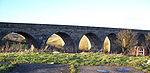
still draws water from the Garnock to turn the restored undershot waterwheel. The mill complex, located off the A737 road north of Kilwinning, is now a tourist attraction with the mill building being home to the Museum of Ayrshire Country Life and Costume. - Kilwinning Viaduct, on the former Lanarkshire and Ayrshire RailwayLanarkshire and Ayrshire RailwayThe Lanarkshire and Ayrshire Railway was a railway company in Scotland built in the late 19th century that provided services between Ardrossan and Glasgow, with branches to Irvine and Kilbirnie. The line was operated by the Caledonian Railway with an aim to compete with the Glasgow and South...
, is now used by the SustransSustransSustrans is a British charity to promote sustainable transport. The charity is currently working on a number of practical projects to encourage people to walk, cycle and use public transport, to give people the choice of "travelling in ways that benefit their health and the environment"...
Garnock Valley Cycleway to get across the river. - Eglinton Country ParkEglinton Country ParkEglinton Country Park is located in the grounds of the old Eglinton Castle estate, Kilwinning, North Ayrshire, Scotland . Eglinton Park is situated in the parish of Kilwinning, part of the former district of Cunninghame, and covers an area of 400 hectares...
was developed around the ancient Eglinton Estate, home for 600 years to the Earls of Eglinton and Winton. - In the River Garnock some distance below Kilwinning Bridge in the Dirrens area, opposite the old saw mill where the lade to the mill started, was Saint NinianSaint NinianSaint Ninian is a Christian saint first mentioned in the 8th century as being an early missionary among the Pictish peoples of what is now Scotland...
's Isle, named after the saint who is otherwise mainly commemorated at WhithornWhithornWhithorn is a former royal burgh in Dumfries and Galloway, Scotland, about ten miles south of Wigtown. The town was the location of the first recorded Christian church in Scotland, Candida Casa : the 'White [or 'Shining'] House', built by Saint Ninian about 397.-Eighth and twelfth centuries:A...
. It is now part of the river banking. - Down river near the confluence with the Lugton Water were the 'Mess(rs?) Johns Steps'; stepping stones across the river as shown on the first edition of the 6 inch OS map.
- Between Ninian's Isle and the steps, just before the bend of the river, is an area named Cullim's Hole.
- Smith records in 1895 that an island called Ringen's Isle existed in the Garnock. This may have been named after Saint Ringen or Winning.
- SalmonAtlantic salmonThe Atlantic salmon is a species of fish in the family Salmonidae, which is found in the northern Atlantic Ocean and in rivers that flow into the north Atlantic and the north Pacific....
generally arrive in the Garnock at the end of July, with the most productive part of the river being the stretch between Kilbirnie and Dalry. - Garnock Floods is a wildlife reserve of the Scottish Wildlife Trust in Kilwinning; sandwiched between the railway line, Sandy Road and the river.
- Ardeer FactoryNobel EnterprisesNobel Enterprises is a chemicals business based at Ardeer, near to the North Ayrshire town of Stevenston in Scotland. It specialises in nitrogen-based propellants and explosives and nitrocellulose-based products such as varnishes and inks...
, once the world's largest commercial explosives factory, is situated on a natural peninsula with the Firth of Clyde on its west side, the River Garnock to the east, and the mouth of the River Irvine to the south.
Pundeavon Burn
- Confluence from the right at Coordinates : 55°45′23"N 4°41′08"W
The Pundeavon Burn drains from Pundeavon Reservoir and enters the Garnock just upstream of Kilbirnie Cross.
Paduff Burn
- Confluence from the right at Coordinates : 55°45′13"N 4°41′08"W
The Paduff Burn is a small stream, known locally as Jock's Burn, which comes into play on the golf course at Kilbirnie Place Golf Club:
Jocks Burn comes in to play at the first 2 holes (Padduff and Place Brae), a short par 3 and then a par 4. The 2nd requires to carry the burn onto an elevated fairway with out of bounds on your right.
The final hole (Jock's Burn) is a short par 3 with a large Oak tree on the left which, if caught, could send your ball into Jock's Burn. With out of bounds on the right and immediately at the back, this a daunting last hole.
Powgree Burn
- Confluence from the left at Coordinates : 55°44′11"N 4°40′46"W
The Powgree Burn rises on Cuff hill in the Gateside
Gateside, North Ayrshire
Gateside is a small village in North Ayrshire, Scotland about half a mile east of Beith on the B777.-The village:Gateside Primary School, headteacher Ms Fiona Dunlop, was opened in 1903, and nowadays it has 74 pupils...
area, runs east of the old Speir's school
Speir's school
Spier's school, at Beith, in North Ayrshire, Scotland, NS 35355327, KA15 1LU, was opened in 1888 and closed in 1972. The school, now demolished, was built using Ballochmyle red sandstone and was reminiscent of the ancient Glasgow University. The school motto was 'Quod verum tutum'...
, through Auchengree
Meikle Auchengree
Meikle Auchengree is a hamlet in North Ayrshire, Scotland.Meikle Auchengree is east of Glengarnock in Dalry parish. The hamlet is situated at the north end of the Auchengree Road which runs between the B777 and the A737 roads. The settlement is today a mixture of farms, small-holdings and...
and Longbar
Longbar
Longbar is a hamlet in North Ayrshire, Scotland, immediately to the east of Glengarnock. It is now a housing estate situated on the low hillside above the Longbar Farm. Originally it was a string of single-storey terraced cottages that ran from the farm east towards the junction of the...
then shortly after runs under Glengarnock railway station
Glengarnock railway station
Glengarnock railway station is a railway station in the village of Glengarnock, North Ayrshire, Scotland, serving the towns of Beith and Kilbirnie...
.
Pitcon Burn
- Confluence from the right at Coordinates : 55°43′09"N 4°42′14"W
The Pitcon Burn cuts deep into the hillside causing the tree lined gully known as Swinlees Glen, a Nature Conservation Site, and enters the Garnock near its namesake Pitcon House.
Rye Water
- Confluence from the right at Coordinates : 55°42′42"N 4°42′28"W
The Rye Water drains from the area of Muirhead Reservoir and Camphill Reservoir and runs through Drakemyre to join the Garnock north of Dalry near Brownhill Junction on the main railway line
Glasgow, Paisley, Kilmarnock and Ayr Railway
The Glasgow, Paisley, Kilmarnock and Ayr Railway was a railway in Scotland that provided train services between Glasgow, Kilmarnock and Ayr. For a short period, it also provided West Coast services between Glasgow and London. Opened in stages between 1839 and 1848, the line ran from Paisley in the...
.
Putyan Burn
Caaf Water
- Confluence from the right at Coordinates : 55°41′52"N 4°42′50"W
The Caaf Water drains from Caaf Reservoir and soon passes the Michelin star rated Braidwoods Restaurant, housed in two simple cottages in the midst of a distinctly rural setting, before entering the Lynn Glen with its picturesque waterfall and finally enters the Garnock south of Dalry.
Bombo Burn
- Confluence from the left at Coordinates : 55°41′28"N 4°42′34"W
The Bombo Burn is a small stream, only about 5 miles (8 km) in length, that runs across the north side of Bankhead Moss, a Special Area of Conservation and joins the Garnock soon after passing through the Blair Estate:
The delightfully landscaped grounds and gardens of the Estate contain a wonderful mixture of species trees and shrubs from all over the world. The Bombo Burn meanders gently for a mile through the gardens creating many natural beauty spots. The ancient yew tree recorded in the Domesday BookDomesday BookDomesday Book , now held at The National Archives, Kew, Richmond upon Thames in South West London, is the record of the great survey of much of England and parts of Wales completed in 1086...
leans over the banks of the Bombo Burn presiding on the changes over the centuries.
Dusk Water
- Confluence from the left at Coordinates : 55°40′49"N 4°42′44"W
Beith
Beith is a small town situated in the Garnock Valley in North Ayrshire, Scotland approximately 20-miles south-west of Glasgow. The town is situated on the crest of a hill and was known originally as the "Hill o' Beith" after its Court Hill.-History:-Name:Beith's name is thought to emanate from...
, and runs through Barrmill
Barrmill
Barrmill is a small village in North Ayrshire, Scotland about a mile and a half a mile east of Beith on the road to Lugton. Locally it is known as the Barr.- History :General Roy's survey of 1747 - 55 shows only the farm of High Barr...
to eventually join the Garnock upstream of Dalgarven
Dalgarven Mill
Dalgarven Mill is near Kilwinning, in the Garnock Valley, North Ayrshire, Scotland and it is home to the Museum of Ayrshire Country Life and Costume. The watermill has been completely restored over a number of years and is run by the independent Dalgarven Mill Trust.The village of Dalgarven was...
.
Interesting places along its course, as well as several old watermills, are Giffin House, a large and handsome mansion-house, and Cleeves Cove
Cleeves Cove cave
Cleeves Cove is a cave system on the Dusk Water in North Ayrshire, Scotland, close to the town of Dalry.-The cave system:Cleeves, or Cleaves, cove cave system is situated in the lower bed of carboniferous limestone. It measures around 500 feet if all the passages were put together...
, a system of caves in the Dusk Glen.
Mills
- Coldstream MillHessilheadHessilhead is in Beith, North Ayrshire, Scotland. Hessilhead used to be called Hazlehead or Hasslehead. The lands were part of the Lordship of Giffen, and the Barony of Hessilhead, within the Baillerie of Cunninghame and the Parish of Beith...
is located on the south side of Cuff Hill. The grain mill can still operate today, albeit only for demonstration purposes, with water supplied from the scenic mill dam. - Giffen Mill (or Barr Mill) is a ruined grain mill in the village of BarrmillBarrmillBarrmill is a small village in North Ayrshire, Scotland about a mile and a half a mile east of Beith on the road to Lugton. Locally it is known as the Barr.- History :General Roy's survey of 1747 - 55 shows only the farm of High Barr...
. - Blair Mill was a traditional corn mill for the large Blair estate in Dalry. It was probably built in the late 18th century and ceased to be used as a mill in the 1950s.
- Waterside Mill, lying downstream of the Dusk Glen, is now a residence.
Lugton Water
- Confluence from the left at Coordinates : 55°38′35"N 4°41′08"W
The Lugton Water, the largest tributary of the Garnock, runs 14 miles (22.5 km) from Loch Libo (395 feet above sea-level) in Uplawmoor
Uplawmoor
Uplawmoor is a village in East Renfrewshire, Scotland. Population 590 .Historic Uplawmoor, associated for centuries with the Barony of Caldwell and the Mure family, is still a vibrant community today, although now bereft of many of the services once to be found there...
, through Lugton
Lugton
Lugton is a small village or hamlet in East Ayrshire, Scotland with a population of 80 people. The A736 road runs through on its way from Glasgow, to the north, to Irvine in North Ayrshire. Uplawmoor is the first settlement on this 'Lochlibo Road' to the north and Burnhouse is to the south...
and the parishes of Neilston, Beith, Dunlop, Stewarton and Kilwinning. The Lugton joins the Garnock below the tidal limit, shortly after passing through Eglinton Country Park
Eglinton Country Park
Eglinton Country Park is located in the grounds of the old Eglinton Castle estate, Kilwinning, North Ayrshire, Scotland . Eglinton Park is situated in the parish of Kilwinning, part of the former district of Cunninghame, and covers an area of 400 hectares...
, developed around the ancient estate of the Earl of Eglinton.
River Irvine
- Confluence at Coordinates : 55°26′38"N 4°41′23"W
The two main rivers of North Ayrshire, the Irvine and the Garnock, come together in the estuary at Irvine Harbour where they jointly enter the Firth of Clyde
Firth of Clyde
The Firth of Clyde forms a large area of coastal water, sheltered from the Atlantic Ocean by the Kintyre peninsula which encloses the outer firth in Argyll and Ayrshire, Scotland. The Kilbrannan Sound is a large arm of the Firth of Clyde, separating the Kintyre Peninsula from the Isle of Arran.At...
.
Major tributaries of the Irvine are the Glen Water, Cessnock Water, Kilmarnock Water (combined Fenwick and Craufurdland Waters), Carmel Water and Annick Water..
The Garnock and the Kilwinning mining disaster of 1833
On June 20 1833 the surface of the Garnock was seen to be ruffled and it was discovered that a section of the river bed had collapsed into mineworkings beneath. The river was now flowing into miles of mineworkings of the Snodgrass, Bartonholm and Longford collieries. Attempts were made to block the breach with clay, whin, straw, etc to no avail. The miners had been safely brought to the surface and were able to witness the sight of the river standing dry for nearly a mile downstream, with fish jumping about in all directions. The tide brought in sufficient water to complete the flooding of the workings and the river level returned to normal. The weight of the floodwater was so great that the compressed air broke through the ground in many places and many acres of ground were observed to bubble up like a pan of boiling water. In some places rents and cavities appeared measuring four or five feet in diameter, and from these came a roaring sound described as being like steam escaping from a safety valve. For about five hours great volumes of water and sand were thrown up into the air like fountains and the mining villages of Bartonholm, Snodgrass, Longford and Nethermains were flooded.Archibald William, the enterprising 13th Earl of Eglinton
Earl of Eglinton
Earl of Eglinton is a title in the Peerage of Scotland.Some authorities spell the title: Earl of Eglintoun In 1859 the thirteenth Earl of Eglinton, Archibald Montgomerie, was also created Earl of Winton in the Peerage of the United Kingdom, which gave him an automatic seat in the House of Lords,...
purchased all the lands concerned in 1852 and through the simple expedient of cutting a short canal at Bogend, across the loop of the river involved, he bypassed the breach and once the river course had been drained and sealed off he was able to have the flooded mineworkings pumped out. The breach lay on the sea side of the loop close to Bogend on the Snodgrass Holm side. The Earl leased the mines to Bairds of Gartsherrie and the "Eglinton Iron Works" were born.
The curse of Saint Winning
A legend tells of Saint WinningKilwinning Abbey
Kilwinning Abbey is a ruined abbey located in the centre of the town of Kilwinning, North Ayrshire.-The establishment of the Abbey:The ancient name of the town is 'Segdoune' or 'Saigtown', probably derived from 'Sanctoun', meaning the 'town of the saint'. Saint Winnings festival was on 21 January...
sending his monks to fish in the Garnock, however no matter how hard they tried or how long they persevered they could catch nothing. The saint in response placed a curse on the river, preventing it from ever having fish in its waters; the river responded by changing course and thereby avoiding the curse. It is clear that the river has substantially changed its course in recorded history, previously having entered the sea at Stevenston. Ardeer therefore being an island at that time. Blaeu's map printed in 1654 shows this.
It was also noted during the construction of a canal serving early coal pits at Ardeer that the small lochans used to ease construction lay on the old course of the River Garnock.
External links
- Ayrshire Rivers Trust
- GarnockFocus blog - Many images in and around the river Garnock.