
Knockentiber
Encyclopedia
Knockentiber is a village in East Ayrshire
, Parish of Kilmaurs
, Scotland. Knockentiber is 2 miles (3.2 km) WNW of Kilmarnock
and 1/2 mile NE of Crosshouse. Latitude:55.6193°N Longitude:4.5455°W and . The population was 359 in 1991, however the population is much higher following the construction of several housing estates (2007). In the 18th and 19th and mid 20th centuries the locality was a highly industrialised coal mining district. The settlement is on the Carmel Burn, which runs into the River Irvine
, a mile or so to the south.
 Knockentiber lies on the old toll road from Kilmaurs to Crosshouse, with a junction for Kilmarnock and a country road leading to Busbiehill, West Plann, Southhook and ultimately the Cunninghamhead
and Perceton
districts. A minor road branches off for Busbiehill and Knockentiber.
Busbie is more or less an alternative name for the area until the Royal Mail
reorganised its postal districts in the 1930s when many hamlets and other localities ceased to exist in the eyes of that body. Busbiehill, Busbie mains, Busbie holdings, Busbie cottages and Busbiehead are still extant nearby.
Archibald Adamson walking through the area in 1875 remarks on the handsome railway bridge and his view of the Plann estate and the extensive fireclay works of John McNight and Son, the senior partner being the owner of the estate of Plann. A pit had been sunk near the mansion house and to the surprise of all the experts, good quality ironstone was found. Top quaility coal and fireclay were also found in the vicinity. He describes Knockentiber as being a row of old houses occupied by miners.
Laigh Milton viaduct
over the River Irvine is situated near Gatehead, a few miles away on the other side of Crosshouse. This is the oldest railway viaduct in Scotland and one of the oldest in the World.
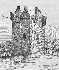 Knockentiber was close to several country estates which provided employment and helped create the need for the establishment of settlements such as Knockentiber. The old castle, a ruin since at leat the 1770s was demolished in 1949 or 1952
Knockentiber (Scottish Gaelic: Cnoc an Tobair, hill of the well) is a village in East Ayrshire
, Parish of Kilmaurs
, Scotland. Knockentiber is 2 miles (3.2 km) WNW of Kilmarnock
and 1/2 mile NE of Crosshouse. Latitude:55.6193°N Longitude:4.5455°W and . The population was 359 in 1991, however the population is much higher following the construction of several housing estates (2007). In the 18th and 19th and mid 20th centuries the locality was a highly industrialised coal mining district. The settlement is on the Carmel Burn, which runs into the River Irvine
, a mile or so to the south.
Knockentiber lies on the old toll road from Kilmaurs to Crosshouse, with a junction for Kilmarnock and a country road leading to Busbiehill, West Plann, Southhook and ultimately the Cunninghamhead
and Perceton
districts. A minor road branches off for Busbiehill and Knockentiber.
Busbie is more or less an alternative name for the area until the Royal Mail
reorganised its postal districts in the 1930s when many hamlets and other localities ceased to exist in the eyes of that body.Strawhorn, John and Boyd, William (1951). The Third Statistical Account of Scotland. Ayrshire. Pub. Edinburgh. Busbiehill, Busbie mains, Busbie holdings, Busbie cottages and Busbiehead are still extant nearby.
Archibald AdamsonAdamson, Archibald R. (1875). Rambles Round Kilmarnock. Pub. Kilmarnock. Pps. 93 - 94. walking through the area in 1875 remarks on the handsome railway bridge and his view of the Plann estate and the extensive fireclay works of John McNight and Son, the senior partner being the owner of the estate of Plann. A pit had been sunk near the mansion house and to the surprise of all the experts, good quality ironstone was found. Top quaility coal and fireclay were also found in the vicinity. He describes Knockentiber as being a row of old houses occupied by miners.
Laigh Milton viaduct
over the River Irvine is situated near Gatehead, a few miles away on the other side of Crosshouse. This is the oldest railway viaduct in Scotland and one of the oldest in the World.
Knockentiber was close to several country estates which provided employment and helped create the need for the establishment of settlements such as Knockentiber. The old castle, a ruin since at leat the 1770s was demolished in 1949Strawhorn, John and Boyd, William (1951). The Third Statistical Account of Scotland. Ayrshire. Pub. P. 475 or 1952
Knockentiber (Scottish Gaelic: Cnoc an Tobair, hill of the well) is a village in East Ayrshire
, Parish of Kilmaurs
, Scotland. Knockentiber is 2 miles (3.2 km) WNW of Kilmarnock
and 1/2 mile NE of Crosshouse. Latitude:55.6193°N Longitude:4.5455°W and . The population was 359 in 1991, however the population is much higher following the construction of several housing estates (2007). In the 18th and 19th and mid 20th centuries the locality was a highly industrialised coal mining district. The settlement is on the Carmel Burn, which runs into the River Irvine
, a mile or so to the south.
Knockentiber lies on the old toll road from Kilmaurs to Crosshouse, with a junction for Kilmarnock and a country road leading to Busbiehill, West Plann, Southhook and ultimately the Cunninghamhead
and Perceton
districts. A minor road branches off for Busbiehill and Knockentiber.
Busbie is more or less an alternative name for the area until the Royal Mail
reorganised its postal districts in the 1930s when many hamlets and other localities ceased to exist in the eyes of that body.Strawhorn, John and Boyd, William (1951). The Third Statistical Account of Scotland. Ayrshire. Pub. Edinburgh. Busbiehill, Busbie mains, Busbie holdings, Busbie cottages and Busbiehead are still extant nearby.
Archibald AdamsonAdamson, Archibald R. (1875). Rambles Round Kilmarnock. Pub. Kilmarnock. Pps. 93 - 94. walking through the area in 1875 remarks on the handsome railway bridge and his view of the Plann estate and the extensive fireclay works of John McNight and Son, the senior partner being the owner of the estate of Plann. A pit had been sunk near the mansion house and to the surprise of all the experts, good quality ironstone was found. Top quaility coal and fireclay were also found in the vicinity. He describes Knockentiber as being a row of old houses occupied by miners.
Laigh Milton viaduct
over the River Irvine is situated near Gatehead, a few miles away on the other side of Crosshouse. This is the oldest railway viaduct in Scotland and one of the oldest in the World.
Knockentiber was close to several country estates which provided employment and helped create the need for the establishment of settlements such as Knockentiber. The old castle, a ruin since at leat the 1770s was demolished in 1949Strawhorn, John and Boyd, William (1951). The Third Statistical Account of Scotland. Ayrshire. Pub. P. 475 or 1952Love, Dane (2005) Lost Ayrshire. Ayrshire's Lost Architectural Heritage. Pub. Birlinn Ltd. ISBN 1-84158-356-1. P. 6. H. Ritchie had Busbie House erected as a replacement for the old castle.Love, Dane (2005) Lost Ayrshire. Ayrshire's Lost Architectural Heritage. Pub. Birlinn Ltd. ISBN 1-84158-356-1. P. 6. Busbie Estates and Collective Securities Limited owned a fair amount of land as late as the 1950s.
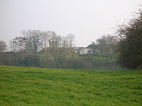 At the back of Greenhill farm, on the top of a steep bank in a circular mound about 21 m in diameter and 4 m in height. It may be an ancient barrow or tumulus. Some years before 1875 several stone coffins were found in a tumulus in a field, called 'Mound field' in 1912 on Waterpark farm. There had been two mounds on this side of the Carmel and the other one at Greenhill. The Waterpark mounds contained many stones, having an appearance of neither having been water worn or weathered; no trace of these two mounds now exists.Adamson, Archibald R. (1875). Rambles Round Kilmarnock. Pub. Kilmarnock. Pps. 93 - 94. The headless skeleton of a large man was found about five feet downRCAHMS Canmore in the Greenhill mound and this led to speculation that a 'Battle of Kilmaurs' had taken place nearby between King Macbeth and Malcolm III, known as Malcolm Canmore. Malcolm was the son of the murdered King Duncan and on this occasion he was forced to escape to his castle at Corsehill in Stewarton
. He was nearly captured by MacBeth's soldiers, however a peasant named Friskin
hid him by covering him with straw, hence the "Over Fork over" motto of the Cunninghame
s and Stewarton.
Whilst sinking a well at the edge of the mound in the 19th century the workmen found large quantities of chaff and charred wood. This suggests that the hill had been extensively used for 'shillin' or 'sheiling', this being the winnowing of corn before the invention of fanners. The finding of stones of steadily increasing size suggests that another grave lies beneath. When the railway was built a stone coffin was unearthed, similar to those in the Waterpark mounds.*McNaught, Duncan (1912). Kilmaurs Parish and Burgh. Pub. A.Gardner. Pps. 35 - 39
the mob met with Bailie Finnie and the local constables, resulting in a 'battle' in which stones were for the most part the weapons of choice. In the meantime the cart of meal and grain was taken to the town centre and the food was handed out to the needy. Despite the boldest of the act, only a few stragglers were punished by the sheriff and William Brown, 'Diehard' himself, got off scot free.
south to the River Irvine
. It had no manor house and belonged to the Eglinton family latterly. Hugh Montgomerie, Ist Earl of Eglinton, had a charter on 3 February 1499 from James V of the £40 lands of old extent of Roberton in Cunninghame.Eglinton Country Park archives. These lands were part of the Lands and Barony of Ardrossan; the following properties were part of the barony: parts of Kilmaurs, Knockentiber, Craig, Gatehead, Woodhills, Greenhill, Altonhill, Plann, Hayside, Thorntoun
, Rash-hill Park, Milton, Windyedge, Fardelhill, Muirfields, Corsehouse.
, including Carmel Bank, previously a Cuninghame property lies towards Springside
. It was home to various families, such as the Montgomeries, Ross's, Mures, Cuninghame's, Peebles, Wreys and Sturrocks, before becoming a school, opened by Barnardo's
in September 1971 for children with emotional difficulties aged 11 to 16 years. The school closed in 1990 and Thorntoun finally became a nursing home. GroomeGroome, Francis H. (1880-85) Ordnance Gazetteer of Scotland: A Survey of Scottish Topography, Statistical, Biographical and Historical, published in parts by Thomas C. Jack, Grange Publishing Works, Edinburgh. refers to a mansion house at Knockentiber circa 1885, but gives no further details.
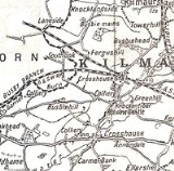
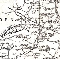
 The 1860, 1898 - 1904 and, 1923 and 1912 OS maps all show that the extent to which Knockentiber was surrounded by collieries, coal pits and freight only railway or 'tram' lines. Collieries were located near Busbie farm and Plann. These were served by standard gauge
mineral railway lines, criss-crossing the countryside; they all now lifted, with only a few embankments left to indicate their original course. In 1860 numerous old and current coal pits dotted the area. The waste bings of Busbie Colliery still lie close to Busbie farm in the field across the road. Greenhill freestone quarry lay over towards Waterpark and several limekilns were present near the Carmel Ford, etc. J. & R. Howie had extracted coal and clay under licence from the National Coal Board in 1951. Tiles were made at the rail served Plann Brickworks and Balgray Bauxite
Company had a small mine at Fardalehill. Quarry house still stands.
Plann Fireclay Works was a very large works making a range of products including salt-glazed sewer pipes. It had 14 downdraught kilns, some rectangular and some round, and at least one Newcastle kiln. This works closed in 1969, and was demolished in 1978. It was probably the largest works of its kind in Scotland.
opened on 4 April 1843 as Busby. Busby station had a short life and closed on 15 April 1850, however the station reopened as Crosshouse (then as part of the Glasgow and South Western Railway
) on 1 September 1872.and closed permanently to passengers on 6 April 1964.Butt, R. V. J. (1995). The Directory of Railway Stations. Patrick Stephens Ltd, Sparkford. ISBN 1-85260-508-1.
Busbie Junction branched off to the Glasgow, Paisley, Kilmarnock and Ayr Railway
(G&SWR) Busbie Branch to Irvine via Springside
and Dreghorn
. A milestone near Busbie Junction on the bridge over the Carmel, shown on the 1860 OS map appears to read Glasgow 32 miles (51.5 km) and Gretna 84 miles (135.2 km).
The old railway from Kilmarnock to Irvine, branching off at Busbie Junction (Crosshouse station), has become a tarmaced cyclepath, maintained by Sustrans.Sustrans Cyclepaths
 The hinge allowed it to 'open' or 'turn' This bar looked like the 'pike' used as a weapon in the army at that time and therefore we get 'turnpike'. The term was also used by the military for barriers set up on roads specifically to prevent the passage of horses. In addition to providing better surfaces and more direct routes, the turnpikes settled the confusion of the different lengths given to miles,Thomson, John (1828). A Map of the Northern Part of Ayrshire. which varied from 4,854 to nearly 7000 feet (2,133.6 m). Long miles, short miles, Scotch or Scot's miles (5,928 ft), Irish miles (6,720 ft), etc. all existed. 5280 feet (1,609.3 m) seems to have been an average! Another important point is that when these new toll roads were constructed the Turnpike Trusts went to a great deal of trouble to improve the route of the new road and these changes could be quite considerable as the old roads tended to go from farm to farm, hardly the shortest route. The tolls on roads were abolished in 1878 to be replaced by a road 'assessment', which was taken over by the County Council in 1889.
Most milestones are no longer in situ and often the only remaining clue is an otherwise unexplained 'kink' in the line of a hedgerow. The milestones were buried during the Second World War so as not to provide assistance to invading troops, German spies, etc.Wilson, Jenny (2006). Oral communication with Griffith, R.S.Ll. This seems to have happened all over Scotland, however Fife was more fortunate than Ayrshire, for the stones were taken into storage and put back in place after the war had finished.Stephen, Walter M. (1967-68). Milestones and Wayside Markers in Fife. Proc Soc Antiq Scot, V.100. P. 184.
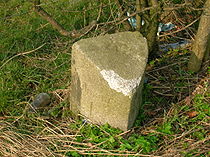
The 1860 OS does not indicated the milestone opposite Busbie farm, embedded in the tarmac of the pavement. It is marked on the circa 1983 OS map. This milestone is granite and has had its 'information' deleted by a coat of cement being applied to the surface, some of which has come off, revealing 'Crosshouse' and 'Kilmaurs'. This may have been by an assiduous workman 'blotting out' the information on a milestone which could not be buried easily; the fate of so many other milestones. Another milestone survives near to the entrance to Carmyle or Waterpark farm. It appears to have read Kilmaurs 1 miles (1.6 km) and Crosshouse 2 miles (3.2 km), the lettering is also obscured by a 'wash' of cement.
side of the old railway. Fardalehill is on the Kilmarnock road and Fergushill lies towards West Plann and Busbie Mains.
extraction, having been brought up here to break a coal workers strike in the 1880s. They brought names like 'Chynoweth' with them, pronounced 'She-no-ef', Cornish
or Kernewek for 'New House'.
Andrew Fisher
from nearby Crosshouse was Prime Minister of Australia on three occasions in the early 1900s.
 On the 1860 OS map the road from Kilmarnock enters via a ford with a wooden footbridge.
In 1912 J. & R. Howie of Plann have a rental income of £703 6s 0d, John Barr has £181 5s 0d and Hugh Robert Wallace of Busbie has the considerable income of £1,451 5s 0d.*McNaught, Duncan (1912). Kilmaurs Parish and Burgh. Pub. A.Gardner.
The 'Tiber Tavern' was opened in the late 1990s, but has struggled to survive and having closed once it has re-opened. The last local shop ceased trading in the 1990s.
The 1860 OS map marks a fine dwelling named as 'Knockentiber House'. This site is still occupied by a similarly dwelling, although apparently much modified. This was presumably the abode of a local business magnate.
Above Busbiehead and Fergushill farms is a plantation on the 1860 OS called 'Lochhead'. This may be another of the many small lochs or lochans drained over the years to provide land for farming. The lochs at Halket
near Lugton and at Lambropughton
are other examples of drained former lochs.
New housing estates have boosted the population considerably (2007).
In 1832 an outbreak of cholera
claimed many lives in Kilmaurs
and to prevent the entrance of strangers or vagrants, guards were placed at Knockentiber, Gatehead and other places to prevent any communication between the occupants of Kilmaurs and the rest of the community.*McNaught, Duncan (1912). Kilmaurs Parish and Burgh. Pub. A.Gardner. P. 254.
East Ayrshire
East Ayrshire is one of 32 council areas of Scotland. It borders on to North Ayrshire, East Renfrewshire, South Lanarkshire, South Ayrshire and Dumfries and Galloway...
, Parish of Kilmaurs
Kilmaurs
Kilmaurs is a village in East Ayrshire, Scotland. It lies on the Carmel, 21.1 miles south by west of Glasgow. Population recorded in 2001 Census, 2601- History :...
, Scotland. Knockentiber is 2 miles (3.2 km) WNW of Kilmarnock
Kilmarnock
Kilmarnock is a large burgh in East Ayrshire, Scotland, with a population of 44,734. It is the second largest town in Ayrshire. The River Irvine runs through its eastern section, and the Kilmarnock Water passes through it, giving rise to the name 'Bank Street'...
and 1/2 mile NE of Crosshouse. Latitude:55.6193°N Longitude:4.5455°W and . The population was 359 in 1991, however the population is much higher following the construction of several housing estates (2007). In the 18th and 19th and mid 20th centuries the locality was a highly industrialised coal mining district. The settlement is on the Carmel Burn, which runs into the River Irvine
River Irvine
The River Irvine is a river flowing through southwest Scotland, with its watershed on the Lanarkshire border of Ayrshire at an altitude of above sea-level, near Drumclog, and SW by W of Strathaven...
, a mile or so to the south.
Introduction
Cunninghamhead
Cunninghamhead is a hamlet in North Ayrshire, Scotland. It was the centre of the lands of Cunninghamhead, Perceton and Annick Lodge in Cunninghame...
and Perceton
Perceton
Perceton is a medieval settlement and estate in North Ayrshire, Scotland, near the town of Irvine. The old church in Perceton is one of the oldest buildings in the Irvine district...
districts. A minor road branches off for Busbiehill and Knockentiber.
History
Ainslie's map of 1822 marks the site of the settlement as Bushby, although a 'Knockintiber' is marked as being nearby. The name 'Knokmdybir' is marked on Pont's map of 1604, but no mention is made of Busbie. Armstrong's map of 1775, shows both Busbie as a ruin with woodland policies and Knockentiber as a separate settlement nearby.The 1860 OS shows that a pre-reformation chapel dedicated to the Virgin Mary was situated close to the site of Busbie Castle. A small hamlet of thatched cottages was also clustered near the castle, making this a distinct settlement at that time. In 1860 the OS shows 'Old Busbie' on the opposite side of the road from the site of the castle. Busbie and Knockentiber progressively grew together over the years.| Etymology |
| The name Knockentiber, is thought to be derived, according to McNaught, from 'the hillock of the well', and Busbie, 'the town of the bushes', being partly Old Norse Old Norse Old Norse is a North Germanic language that was spoken by inhabitants of Scandinavia and inhabitants of their overseas settlements during the Viking Age, until about 1300.... in origin. |
Busbie is more or less an alternative name for the area until the Royal Mail
Royal Mail
Royal Mail is the government-owned postal service in the United Kingdom. Royal Mail Holdings plc owns Royal Mail Group Limited, which in turn operates the brands Royal Mail and Parcelforce Worldwide...
reorganised its postal districts in the 1930s when many hamlets and other localities ceased to exist in the eyes of that body. Busbiehill, Busbie mains, Busbie holdings, Busbie cottages and Busbiehead are still extant nearby.
Archibald Adamson walking through the area in 1875 remarks on the handsome railway bridge and his view of the Plann estate and the extensive fireclay works of John McNight and Son, the senior partner being the owner of the estate of Plann. A pit had been sunk near the mansion house and to the surprise of all the experts, good quality ironstone was found. Top quaility coal and fireclay were also found in the vicinity. He describes Knockentiber as being a row of old houses occupied by miners.
Laigh Milton viaduct
Laigh Milton Viaduct
Laigh Milton Viaduct is a railway viaduct near Laigh Milton mill at Gatehead in East Ayrshire, Scotland. It lies in the parishes of Kilmaurs and Dundonald, at map reference: NS 3834 3690. The viaduct was closed in 1846 when the railway line was realigned.- Laigh Milton viaduct :The stone viaduct...
over the River Irvine is situated near Gatehead, a few miles away on the other side of Crosshouse. This is the oldest railway viaduct in Scotland and one of the oldest in the World.
Busbie Castle
Knockentiber (Scottish Gaelic: Cnoc an Tobair, hill of the well) is a village in East Ayrshire
East Ayrshire
East Ayrshire is one of 32 council areas of Scotland. It borders on to North Ayrshire, East Renfrewshire, South Lanarkshire, South Ayrshire and Dumfries and Galloway...
, Parish of Kilmaurs
Kilmaurs
Kilmaurs is a village in East Ayrshire, Scotland. It lies on the Carmel, 21.1 miles south by west of Glasgow. Population recorded in 2001 Census, 2601- History :...
, Scotland. Knockentiber is 2 miles (3.2 km) WNW of Kilmarnock
Kilmarnock
Kilmarnock is a large burgh in East Ayrshire, Scotland, with a population of 44,734. It is the second largest town in Ayrshire. The River Irvine runs through its eastern section, and the Kilmarnock Water passes through it, giving rise to the name 'Bank Street'...
and 1/2 mile NE of Crosshouse. Latitude:55.6193°N Longitude:4.5455°W and . The population was 359 in 1991, however the population is much higher following the construction of several housing estates (2007). In the 18th and 19th and mid 20th centuries the locality was a highly industrialised coal mining district. The settlement is on the Carmel Burn, which runs into the River Irvine
River Irvine
The River Irvine is a river flowing through southwest Scotland, with its watershed on the Lanarkshire border of Ayrshire at an altitude of above sea-level, near Drumclog, and SW by W of Strathaven...
, a mile or so to the south.
Introduction
Cunninghamhead
Cunninghamhead is a hamlet in North Ayrshire, Scotland. It was the centre of the lands of Cunninghamhead, Perceton and Annick Lodge in Cunninghame...
and Perceton
Perceton
Perceton is a medieval settlement and estate in North Ayrshire, Scotland, near the town of Irvine. The old church in Perceton is one of the oldest buildings in the Irvine district...
districts. A minor road branches off for Busbiehill and Knockentiber.
History
Ainslie'sAinslie, John (1821). A Map of the Southern Part of Scotland. map of 1822 marks the site of the settlement as Bushby, although a 'Knockintiber' is marked as being nearby. The name 'Knokmdybir' is marked on Pont's map of 1604,Pont, Timothy (1604). Cuninghamia. Pub. Blaeu in 1654. but no mention is made of Busbie. Armstrong's map of 1775, shows both Busbie as a ruin with woodland policies and Knockentiber as a separate settlement nearby.Armstrong and Son. Engraved by S. Pyle (1775). A New Map of Ayr Shire comprehending Kyle, Cunningham and Carrick.The 1860 OS shows that a pre-reformation chapel dedicated to the Virgin Mary was situated close to the site of Busbie Castle. A small hamlet of thatched cottages was also clustered near the castle, making this a distinct settlement at that time. In 1860 the OS shows 'Old Busbie' on the opposite side of the road from the site of the castle. Busbie and Knockentiber progressively grew together over the years.| Etymology |
| The name Knockentiber, is thought to be derived, according to McNaught,McNaught, Duncan (1912). Kilmaurs Parish and Burgh. Pub. A.Gardner. from 'the hillock of the well', and Busbie, 'the town of the bushes', being partly Old Norse Old Norse Old Norse is a North Germanic language that was spoken by inhabitants of Scandinavia and inhabitants of their overseas settlements during the Viking Age, until about 1300.... in origin. |
Busbie is more or less an alternative name for the area until the Royal Mail
Royal Mail
Royal Mail is the government-owned postal service in the United Kingdom. Royal Mail Holdings plc owns Royal Mail Group Limited, which in turn operates the brands Royal Mail and Parcelforce Worldwide...
reorganised its postal districts in the 1930s when many hamlets and other localities ceased to exist in the eyes of that body.Strawhorn, John and Boyd, William (1951). The Third Statistical Account of Scotland. Ayrshire. Pub. Edinburgh. Busbiehill, Busbie mains, Busbie holdings, Busbie cottages and Busbiehead are still extant nearby.
Archibald AdamsonAdamson, Archibald R. (1875). Rambles Round Kilmarnock. Pub. Kilmarnock. Pps. 93 - 94. walking through the area in 1875 remarks on the handsome railway bridge and his view of the Plann estate and the extensive fireclay works of John McNight and Son, the senior partner being the owner of the estate of Plann. A pit had been sunk near the mansion house and to the surprise of all the experts, good quality ironstone was found. Top quaility coal and fireclay were also found in the vicinity. He describes Knockentiber as being a row of old houses occupied by miners.
Laigh Milton viaduct
Laigh Milton Viaduct
Laigh Milton Viaduct is a railway viaduct near Laigh Milton mill at Gatehead in East Ayrshire, Scotland. It lies in the parishes of Kilmaurs and Dundonald, at map reference: NS 3834 3690. The viaduct was closed in 1846 when the railway line was realigned.- Laigh Milton viaduct :The stone viaduct...
over the River Irvine is situated near Gatehead, a few miles away on the other side of Crosshouse. This is the oldest railway viaduct in Scotland and one of the oldest in the World.
Busbie Castle
Knockentiber's greenhills
Stewarton
Stewarton is a town in East Ayrshire, Scotland. In comparison to the neighbouring towns of Kilmaurs, Fenwick, Dunlop and Lugton, it is a relatively large town, with a population of over 6,500. It is 300 feet above sea level.Groome, Francis H. . Ordnance Gazetteer of Scotland. Pub. Caxton. London....
. He was nearly captured by MacBeth's soldiers, however a peasant named Friskin
Lambroughton
Lambroughton is a village in the old Barony of Kilmaurs, North Ayrshire, Scotland. This is a rural area famous for its milk and cheese production and the Ayrshire or Dunlop breed of cattle.-Origins of the name:...
hid him by covering him with straw, hence the "Over Fork over" motto of the Cunninghame
Cunninghame
Cunninghame is a former comital district of Scotland and also a district of the Strathclyde Region from 1975–1996.-Historic Cunninghame:The historic district of Cunninghame was bordered by the districts of Renfrew and Clydesdale to the north and east respectively, by the district of Kyle to the...
s and Stewarton.
Whilst sinking a well at the edge of the mound in the 19th century the workmen found large quantities of chaff and charred wood. This suggests that the hill had been extensively used for 'shillin' or 'sheiling', this being the winnowing of corn before the invention of fanners. The finding of stones of steadily increasing size suggests that another grave lies beneath. When the railway was built a stone coffin was unearthed, similar to those in the Waterpark mounds.*McNaught, Duncan (1912). Kilmaurs Parish and Burgh. Pub. A.Gardner. Pps. 35 - 39
Diehard's raid on Greenhill Farm
James Paterson,Paterson, James (1871). Autobiographical Reminiscences. Pub. Maurice Ogle & Co. Glasgow. P. 138 - 132. the historian, relates that Greenhill Farm was then owned by Bailie Finnie, an unpopular man, due to his officious handling of the radical disturbances of the time. In 1829, one William Brown, known as 'Diehard' due to his army experiences, led a hungry mob to Greenhill which was known to hold considerable hoarded supplies of meal and grain. The farm domestics were taken by surprise, no difficulty was encountered in obtaining the food supplies and no wanton damage perpetrated. On the return journey to KilmarnockKilmarnock
Kilmarnock is a large burgh in East Ayrshire, Scotland, with a population of 44,734. It is the second largest town in Ayrshire. The River Irvine runs through its eastern section, and the Kilmarnock Water passes through it, giving rise to the name 'Bank Street'...
the mob met with Bailie Finnie and the local constables, resulting in a 'battle' in which stones were for the most part the weapons of choice. In the meantime the cart of meal and grain was taken to the town centre and the food was handed out to the needy. Despite the boldest of the act, only a few stragglers were punished by the sheriff and William Brown, 'Diehard' himself, got off scot free.
The Barony of Robertoun
This barony, once part of the Barony of Kilmaurs, ran from KilmaursKilmaurs
Kilmaurs is a village in East Ayrshire, Scotland. It lies on the Carmel, 21.1 miles south by west of Glasgow. Population recorded in 2001 Census, 2601- History :...
south to the River Irvine
River Irvine
The River Irvine is a river flowing through southwest Scotland, with its watershed on the Lanarkshire border of Ayrshire at an altitude of above sea-level, near Drumclog, and SW by W of Strathaven...
. It had no manor house and belonged to the Eglinton family latterly. Hugh Montgomerie, Ist Earl of Eglinton, had a charter on 3 February 1499 from James V of the £40 lands of old extent of Roberton in Cunninghame.Eglinton Country Park archives. These lands were part of the Lands and Barony of Ardrossan; the following properties were part of the barony: parts of Kilmaurs, Knockentiber, Craig, Gatehead, Woodhills, Greenhill, Altonhill, Plann, Hayside, Thorntoun
Thorntoun house and estate
Thorntoun School was opened by Barnardo's in September 1971 for children with emotional difficulties aged 11 to 16 years. The school closed in 1990 and Thorntoun is now a Nursing Home. The complex lies between the villages of Springside and Crosshouse, Kilmarnock in East Ayrshire, Scotland...
, Rash-hill Park, Milton, Windyedge, Fardelhill, Muirfields, Corsehouse.
Thorntoun and other estates
Thorntoun house and estateThorntoun house and estate
Thorntoun School was opened by Barnardo's in September 1971 for children with emotional difficulties aged 11 to 16 years. The school closed in 1990 and Thorntoun is now a Nursing Home. The complex lies between the villages of Springside and Crosshouse, Kilmarnock in East Ayrshire, Scotland...
, including Carmel Bank, previously a Cuninghame property lies towards Springside
Springside
Springside may refer to:*Springside, Ayrshire, a village in Scotland*Springside , estate of Matthew Vassar with landscaped grounds in Poughkeepsie, New York, U.S.A....
. It was home to various families, such as the Montgomeries, Ross's, Mures, Cuninghame's, Peebles, Wreys and Sturrocks, before becoming a school, opened by Barnardo's
Barnardo's
Barnardo's is a British charity founded by Thomas John Barnardo in 1866, to care for vulnerable children and young people. As of 2010, it spends over £190 million each year on more than 400 local services aimed at helping these same groups...
in September 1971 for children with emotional difficulties aged 11 to 16 years. The school closed in 1990 and Thorntoun finally became a nursing home. GroomeGroome, Francis H. (1880-85) Ordnance Gazetteer of Scotland: A Survey of Scottish Topography, Statistical, Biographical and Historical, published in parts by Thomas C. Jack, Grange Publishing Works, Edinburgh. refers to a mansion house at Knockentiber circa 1885, but gives no further details.
The Collieries, Coal Pits, Brickworks and Quarries
Standard gauge
The standard gauge is a widely-used track gauge . Approximately 60% of the world's existing railway lines are built to this gauge...
mineral railway lines, criss-crossing the countryside; they all now lifted, with only a few embankments left to indicate their original course. In 1860 numerous old and current coal pits dotted the area. The waste bings of Busbie Colliery still lie close to Busbie farm in the field across the road. Greenhill freestone quarry lay over towards Waterpark and several limekilns were present near the Carmel Ford, etc. J. & R. Howie had extracted coal and clay under licence from the National Coal Board in 1951. Tiles were made at the rail served Plann Brickworks and Balgray Bauxite
Bauxite
Bauxite is an aluminium ore and is the main source of aluminium. This form of rock consists mostly of the minerals gibbsite Al3, boehmite γ-AlO, and diaspore α-AlO, in a mixture with the two iron oxides goethite and hematite, the clay mineral kaolinite, and small amounts of anatase TiO2...
Company had a small mine at Fardalehill. Quarry house still stands.
Plann Fireclay Works was a very large works making a range of products including salt-glazed sewer pipes. It had 14 downdraught kilns, some rectangular and some round, and at least one Newcastle kiln. This works closed in 1969, and was demolished in 1978. It was probably the largest works of its kind in Scotland.
Miner's Rows
The County Council in 1932 planned to demolish most of the old miners' rows, a local case being Southhook row near Southhook farm.Strawhorn, John and Boyd, William (1951). The Third Statistical Account of Scotland. Ayrshire. Pub. P. 475 the 1895 OS shows a Fardlehill miners row on the Kilmarnock side of the farm, near Ellerslie.The Railway
Crosshouse railway stationCrosshouse railway station
Crosshouse railway station was a railway station serving the village of Knockentiber and nearby Crosshouse, East Ayrshire, Scotland. The station was originally part of the Glasgow, Paisley, Kilmarnock and Ayr Railway.-History:...
opened on 4 April 1843 as Busby. Busby station had a short life and closed on 15 April 1850, however the station reopened as Crosshouse (then as part of the Glasgow and South Western Railway
Glasgow and South Western Railway
The Glasgow and South Western Railway , one of the pre-grouping railway companies, served a triangular area of south-west Scotland, between Glasgow, Stranraer and Carlisle...
) on 1 September 1872.and closed permanently to passengers on 6 April 1964.Butt, R. V. J. (1995). The Directory of Railway Stations. Patrick Stephens Ltd, Sparkford. ISBN 1-85260-508-1.
Busbie Junction branched off to the Glasgow, Paisley, Kilmarnock and Ayr Railway
Glasgow, Paisley, Kilmarnock and Ayr Railway
The Glasgow, Paisley, Kilmarnock and Ayr Railway was a railway in Scotland that provided train services between Glasgow, Kilmarnock and Ayr. For a short period, it also provided West Coast services between Glasgow and London. Opened in stages between 1839 and 1848, the line ran from Paisley in the...
(G&SWR) Busbie Branch to Irvine via Springside
Springside
Springside may refer to:*Springside, Ayrshire, a village in Scotland*Springside , estate of Matthew Vassar with landscaped grounds in Poughkeepsie, New York, U.S.A....
and Dreghorn
Dreghorn
Dreghorn is a village near Irvine, North Ayrshire, Scotland. This parish comprehends the old parishes of Dreghorn and Pearston, which were united in 1668. The whole of the parish was historically the property of the De Morvilles, who were Constables of Scotland and Lords of Cunninghame...
. A milestone near Busbie Junction on the bridge over the Carmel, shown on the 1860 OS map appears to read Glasgow 32 miles (51.5 km) and Gretna 84 miles (135.2 km).
The old railway from Kilmarnock to Irvine, branching off at Busbie Junction (Crosshouse station), has become a tarmaced cyclepath, maintained by Sustrans.Sustrans Cyclepaths
The Turnpike
Knockentiber was on a toll road or turnpike; the nearest toll house being opposite the entrance to the old Goods station; the backwall of the building remaining as the field boundary. The name 'Turnpike' originated from the original 'gate' used being just a simple wooden bar attached at one end to a hinge on the supporting post.| Etymology |
| Carmel, the oldest form of which is Caremuall, is thought to be derived, according to McNaught,*McNaught, Duncan (1912). Kilmaurs Parish and Burgh. Pub. A.Gardner. from the Gaelic 'Car' meaning a 'fort', and 'Meall'. meaning a hill. Therefore, 'The fort on the hill'. |
Most milestones are no longer in situ and often the only remaining clue is an otherwise unexplained 'kink' in the line of a hedgerow. The milestones were buried during the Second World War so as not to provide assistance to invading troops, German spies, etc.Wilson, Jenny (2006). Oral communication with Griffith, R.S.Ll. This seems to have happened all over Scotland, however Fife was more fortunate than Ayrshire, for the stones were taken into storage and put back in place after the war had finished.Stephen, Walter M. (1967-68). Milestones and Wayside Markers in Fife. Proc Soc Antiq Scot, V.100. P. 184.
The 1860 OS does not indicated the milestone opposite Busbie farm, embedded in the tarmac of the pavement. It is marked on the circa 1983 OS map. This milestone is granite and has had its 'information' deleted by a coat of cement being applied to the surface, some of which has come off, revealing 'Crosshouse' and 'Kilmaurs'. This may have been by an assiduous workman 'blotting out' the information on a milestone which could not be buried easily; the fate of so many other milestones. Another milestone survives near to the entrance to Carmyle or Waterpark farm. It appears to have read Kilmaurs 1 miles (1.6 km) and Crosshouse 2 miles (3.2 km), the lettering is also obscured by a 'wash' of cement.
Farms
West Plann (previously Planne) and Greenhill are nearby. South Woodhill and Carmyle or Waterpark lies on the KilmaursKilmaurs
Kilmaurs is a village in East Ayrshire, Scotland. It lies on the Carmel, 21.1 miles south by west of Glasgow. Population recorded in 2001 Census, 2601- History :...
side of the old railway. Fardalehill is on the Kilmarnock road and Fergushill lies towards West Plann and Busbie Mains.
Busbie Mill
The present Busbie farm is marked on the older maps, e.g. 1860, as a mill, with a clear millrace or lade and a sluice. The water was taken from the Carmel somewhere in the vicinity of a dwelling marked as Busbie Holm, rejoining the burn just beyond the mill. It is not clear as to when the mill ceased to operate. It is likely that the mill was associated with the Lairds of Busbie. A Robertown mill is known to have existed, named from the title of the Barony.Football club
Knockentiber has a history up to the present day (2007) of fielding very successful amateur football teams. The football pitch and associated facilities are literally at the centre of the community.Local history and traditions of the area
StrawhornStrawhorn, John and Boyd, William (1951). The Third Statistical Account of Scotland. Ayrshire. Pub. P. 470 states in 1951 that a fair number of inhabitants are of CornishCornish people
The Cornish are a people associated with Cornwall, a county and Duchy in the south-west of the United Kingdom that is seen in some respects as distinct from England, having more in common with the other Celtic parts of the United Kingdom such as Wales, as well as with other Celtic nations in Europe...
extraction, having been brought up here to break a coal workers strike in the 1880s. They brought names like 'Chynoweth' with them, pronounced 'She-no-ef', Cornish
Cornish language
Cornish is a Brythonic Celtic language and a recognised minority language of the United Kingdom. Along with Welsh and Breton, it is directly descended from the ancient British language spoken throughout much of Britain before the English language came to dominate...
or Kernewek for 'New House'.
Andrew Fisher
Andrew Fisher
Andrew Fisher was an Australian politician who served as the fifth Prime Minister on three separate occasions. Fisher's 1910-13 Labor ministry completed a vast legislative programme which made him, along with Protectionist Alfred Deakin, the founder of the statutory structure of the new nation...
from nearby Crosshouse was Prime Minister of Australia on three occasions in the early 1900s.
In 1912 J. & R. Howie of Plann have a rental income of £703 6s 0d, John Barr has £181 5s 0d and Hugh Robert Wallace of Busbie has the considerable income of £1,451 5s 0d.*McNaught, Duncan (1912). Kilmaurs Parish and Burgh. Pub. A.Gardner.
The 'Tiber Tavern' was opened in the late 1990s, but has struggled to survive and having closed once it has re-opened. The last local shop ceased trading in the 1990s.
The 1860 OS map marks a fine dwelling named as 'Knockentiber House'. This site is still occupied by a similarly dwelling, although apparently much modified. This was presumably the abode of a local business magnate.
Above Busbiehead and Fergushill farms is a plantation on the 1860 OS called 'Lochhead'. This may be another of the many small lochs or lochans drained over the years to provide land for farming. The lochs at Halket
Halket Loch
Halket Loch , also known as Halkhead or Halketh, was situated in the mid-Ayrshire clayland near Lugton. It is visible as a surface depression in pastureland, sometimes partially flooded, situated in a low lying area close to farms and dwellings of East, North and Middle Halket and Craighead in the...
near Lugton and at Lambropughton
Lambroughton Loch
Lambroughton Loch or Wheatrig Loch was situated in a low lying area between the farms and dwellings of Hillhead, Lambroughton, Wheatrig, Titwood and Lochridge mainly in the Parish of Dreghorn, North Ayrshire...
are other examples of drained former lochs.
New housing estates have boosted the population considerably (2007).
In 1832 an outbreak of cholera
Cholera
Cholera is an infection of the small intestine that is caused by the bacterium Vibrio cholerae. The main symptoms are profuse watery diarrhea and vomiting. Transmission occurs primarily by drinking or eating water or food that has been contaminated by the diarrhea of an infected person or the feces...
claimed many lives in Kilmaurs
Kilmaurs
Kilmaurs is a village in East Ayrshire, Scotland. It lies on the Carmel, 21.1 miles south by west of Glasgow. Population recorded in 2001 Census, 2601- History :...
and to prevent the entrance of strangers or vagrants, guards were placed at Knockentiber, Gatehead and other places to prevent any communication between the occupants of Kilmaurs and the rest of the community.*McNaught, Duncan (1912). Kilmaurs Parish and Burgh. Pub. A.Gardner. P. 254.