
Americano Creek
Encyclopedia
Americano Creek is a 7.5 miles (12 km) long westward-flowing stream
in the California
counties of Sonoma
and Marin
, which flows into the Estero Americano, a 9.2 mi (15 km) long estuary
, and thence to the Pacific Ocean
. This article covers both watercourse
s.
and runs westward, paralleling Roblar Road. It passes a closed landfill
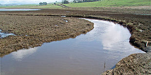
and crosses Valley Ford Road. At this point the channel becomes better defined and also deep enough for kayak
ing in the winter months. Kayakers access the creek here by means of an unpaved boat launch road reachable from Marsh Road.
 The lower reach of the creek flows westward past the small community of Bloomfield
, paralleling Valley Ford Road, and passes under State Route 1, known locally as the Highway 1 or the Shoreline Highway, at which point it begins to define the Sonoma-Marin county line.
Just west of the highway, the watercourse
's official name changes to Estero Americano. It meanders past the town of Valley Ford
. Valley Ford-Franklin School Road crosses at the last bridge across the Estero. Shortly thereafter, Ebabias Creek enters from the north. The last 6 mi (10 km) of the Estero are virtually without road access or visibility from public roads.
The Estero continues to define the county boundary until it reaches the coast, where it empties into Bodega Bay
about 4 mi (6 km) southeast of the town of Bodega Bay
. Its mouth lies near the north end of the Gulf of the Farallones National Marine Sanctuary
.
, contributing to flooding in downstream communities and making the creek non-navigable. Pollutants found at hazardous level in the creek have included fecal bacteria
, copper
, ammonia
, and zinc
.
The creek's headwaters area is a historic habitat for a number of rare
and endangered species
including Sebastopol Meadowfoam, Limnanthes vinculans; Showy Indian clover, Trifolium amoenum
; and Pitkin Marsh lily, Lilium pardolinum ssp pitkinese. This area also contains a closed landfill
, and as of 2006, a hard rock quarry
was proposed for it.
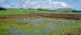
 Americano Creek is dry 4 to 6 months each year. For its first 8 mi (13 km), the stream meanders through a broad valley dominated by agricultural uses, principally cattle
grazing
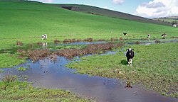
. The valley floor is flat and wide, especially at the lower elevations. Due to siltation, virtually no rocks are evident in the streambed. Grazing occurs in the streambed itself, putting pathogens directly into the water. During the rainy season (November to April), this bottomland consists in places of an expansive marshy area. Most native wetland vegetation has been destroyed by ongoing grazing. Grazing is so intense that cattle are seen wading in a broad marshy streambed over 16 in (40.6 cm) deep and over 300 ft (91.4 m) wide.
The lower reach of Americano Creek is also surrounded by agricultural uses. However, the channel becomes better separated from grazing areas. The Estero itself is a Federally-protected area.
Flow rates are highly seasonal with the heaviest flows occurring in the rainy winter months. Water testing of Americano Creek and the Estero has generally found pH
(acidity) levels in the range of 7.5 to 8.0, which satisfies the guidelines in the State of California Basin Plan.
In some years, a sand bar forms at the mouth of the Estero, restricting tidal exchange. At other times, tidal influences extend up to 4 miles (6 km) from the mouth. High levels of salinity have been observed in the Estero.
village
s were located on the Estero Americano: one named Uli-yomi at the head of the Estero, and another named Awachi at its mouth.
s cross Americano Creek in three locations: Gericke Road, Roblar Road and Valley Ford Road. The newest of these, built in 1985, is the 73 ft (22.3 m) long concrete slab
structure at Valley Ford Road, 3.6 mi (5.8 km) east of the junction with State Route 1
. The oldest of these, built in 1964, is the Roblar Road crossing, a 27 ft (8.2 m) concrete culvert
situated 0.7 mi (1.1 km) east of Valley Ford Road. The Gericke Road bridge is a 107 ft (32.6 m) long concrete continuous slab built in 1972 about 0.2 mi (321.9 m) south of Valley Ford Road.
The Estero Americano is crossed in three places: Valley Ford-Franklin School Road, Highway One, and Slaughter House Road. All three crossing are concrete continuous slab structures. The State Route 1 bridge, built in 1925, is 144 ft (43.9 m) long and located near milepost 50.47. The Valley Ford-Franklin School bridge, built in 1961, is 198 ft (60.4 m) long. The Slaughter House Road bridge, built in 1990, is only 75 ft (22.9 m) long.
Stream
A stream is a body of water with a current, confined within a bed and stream banks. Depending on its locale or certain characteristics, a stream may be referred to as a branch, brook, beck, burn, creek, "crick", gill , kill, lick, rill, river, syke, bayou, rivulet, streamage, wash, run or...
in the California
California
California is a state located on the West Coast of the United States. It is by far the most populous U.S. state, and the third-largest by land area...
counties of Sonoma
Sonoma County, California
Sonoma County, located on the northern coast of the U.S. state of California, is the largest and northernmost of the nine San Francisco Bay Area counties. Its population at the 2010 census was 483,878. Its largest city and county seat is Santa Rosa....
and Marin
Marin County, California
Marin County is a county located in the North San Francisco Bay Area of the U.S. state of California, across the Golden Gate Bridge from San Francisco. As of 2010, the population was 252,409. The county seat is San Rafael and the largest employer is the county government. Marin County is well...
, which flows into the Estero Americano, a 9.2 mi (15 km) long estuary
Estuary
An estuary is a partly enclosed coastal body of water with one or more rivers or streams flowing into it, and with a free connection to the open sea....
, and thence to the Pacific Ocean
Pacific Ocean
The Pacific Ocean is the largest of the Earth's oceanic divisions. It extends from the Arctic in the north to the Southern Ocean in the south, bounded by Asia and Australia in the west, and the Americas in the east.At 165.2 million square kilometres in area, this largest division of the World...
. This article covers both watercourse
Watercourse
A watercourse is any flowing body of water. These include rivers, streams, anabranches, and so forth.-See also:* physical geography* Environmental flow* Waterway* Hydrology* Wadi-External links:...
s.
Course
Americano Creek springs from low-lying coastal hills 4 mi (6 km) west of CotatiCotati, California
Cotati is an incorporated city in Sonoma County, California, U.S.A., located about north of San Francisco in the 101 corridor between Rohnert Park and Petaluma....
and runs westward, paralleling Roblar Road. It passes a closed landfill
Landfill
A landfill site , is a site for the disposal of waste materials by burial and is the oldest form of waste treatment...
and crosses Valley Ford Road. At this point the channel becomes better defined and also deep enough for kayak
Kayak
A kayak is a small, relatively narrow, human-powered boat primarily designed to be manually propelled by means of a double blade paddle.The traditional kayak has a covered deck and one or more cockpits, each seating one paddler...
ing in the winter months. Kayakers access the creek here by means of an unpaved boat launch road reachable from Marsh Road.
Bloomfield, California
Bloomfield is a census-designated place in Sonoma County, California, U.S. It is located in a rural area about southwest of Santa Rosa, California at the junction of Bloomfield Road and Valley Ford Road. Americano Creek flows westward along the south edge of the town.-History:Bloomfield is located...
, paralleling Valley Ford Road, and passes under State Route 1, known locally as the Highway 1 or the Shoreline Highway, at which point it begins to define the Sonoma-Marin county line.
Just west of the highway, the watercourse
Watercourse
A watercourse is any flowing body of water. These include rivers, streams, anabranches, and so forth.-See also:* physical geography* Environmental flow* Waterway* Hydrology* Wadi-External links:...
's official name changes to Estero Americano. It meanders past the town of Valley Ford
Valley Ford, California
Valley Ford is an unincorporated community and census-designated place in western Sonoma County, California, United States. It is located on State Route 1 in an area of rolling hills about 75 minutes north of San Francisco by automobile...
. Valley Ford-Franklin School Road crosses at the last bridge across the Estero. Shortly thereafter, Ebabias Creek enters from the north. The last 6 mi (10 km) of the Estero are virtually without road access or visibility from public roads.
The Estero continues to define the county boundary until it reaches the coast, where it empties into Bodega Bay
Bodega Bay
Bodega Bay is a shallow, rocky inlet of the Pacific Ocean on the coast of northern California in the United States. It is approximately across and is located approximately northwest of San Francisco and west of Santa Rosa...
about 4 mi (6 km) southeast of the town of Bodega Bay
Bodega Bay, California
Bodega Bay is a town and census-designated place in Sonoma County, California, United States. The population was 1,077 at the 2010 census. The town is on the eastern side of Bodega Harbor, an inlet of Bodega Bay on the Pacific coast....
. Its mouth lies near the north end of the Gulf of the Farallones National Marine Sanctuary
Gulf of the Farallones National Marine Sanctuary
The Gulf of the Farallones National Marine Sanctuary is one of 13 marine sanctuaries in the U.S., found outside San Francisco's Golden Gate surrounding the Gulf of the Farallones-History:...
.
Environmental factors
California's 1994 water quality report designated all of Americano Creek and most of the Estero Americano as "impaired" streamways as defined in section 303(d) of the Federal Water Resource Statutes, due to runoff from pasture land and feedlots. As recently as 1987, a single gully near Americano Creek released 4,000 tons/year of sedimentSediment
Sediment is naturally occurring material that is broken down by processes of weathering and erosion, and is subsequently transported by the action of fluids such as wind, water, or ice, and/or by the force of gravity acting on the particle itself....
, contributing to flooding in downstream communities and making the creek non-navigable. Pollutants found at hazardous level in the creek have included fecal bacteria
Bacteria
Bacteria are a large domain of prokaryotic microorganisms. Typically a few micrometres in length, bacteria have a wide range of shapes, ranging from spheres to rods and spirals...
, copper
Copper
Copper is a chemical element with the symbol Cu and atomic number 29. It is a ductile metal with very high thermal and electrical conductivity. Pure copper is soft and malleable; an exposed surface has a reddish-orange tarnish...
, ammonia
Ammonia
Ammonia is a compound of nitrogen and hydrogen with the formula . It is a colourless gas with a characteristic pungent odour. Ammonia contributes significantly to the nutritional needs of terrestrial organisms by serving as a precursor to food and fertilizers. Ammonia, either directly or...
, and zinc
Zinc
Zinc , or spelter , is a metallic chemical element; it has the symbol Zn and atomic number 30. It is the first element in group 12 of the periodic table. Zinc is, in some respects, chemically similar to magnesium, because its ion is of similar size and its only common oxidation state is +2...
.
The creek's headwaters area is a historic habitat for a number of rare
Rare species
A rare species is a group of organisms that are very uncommon or scarce. This designation may be applied to either a plant or animal taxon, and may be distinct from the term "endangered" or "threatened species" but not "extinct"....
and endangered species
Endangered species
An endangered species is a population of organisms which is at risk of becoming extinct because it is either few in numbers, or threatened by changing environmental or predation parameters...
including Sebastopol Meadowfoam, Limnanthes vinculans; Showy Indian clover, Trifolium amoenum
Trifolium amoenum
Trifolium amoenum, known by the common name Showy Indian clover is endemic to California, and is an endangered annual herb that subsists in grassland areas of the San Francisco Bay Area and the northern California Coast Ranges.-Description:...
; and Pitkin Marsh lily, Lilium pardolinum ssp pitkinese. This area also contains a closed landfill
Landfill
A landfill site , is a site for the disposal of waste materials by burial and is the oldest form of waste treatment...
, and as of 2006, a hard rock quarry
Quarry
A quarry is a type of open-pit mine from which rock or minerals are extracted. Quarries are generally used for extracting building materials, such as dimension stone, construction aggregate, riprap, sand, and gravel. They are often collocated with concrete and asphalt plants due to the requirement...
was proposed for it.
Cattle
Cattle are the most common type of large domesticated ungulates. They are a prominent modern member of the subfamily Bovinae, are the most widespread species of the genus Bos, and are most commonly classified collectively as Bos primigenius...
grazing
Grazing
Grazing generally describes a type of feeding, in which a herbivore feeds on plants , and also on other multicellular autotrophs...
. The valley floor is flat and wide, especially at the lower elevations. Due to siltation, virtually no rocks are evident in the streambed. Grazing occurs in the streambed itself, putting pathogens directly into the water. During the rainy season (November to April), this bottomland consists in places of an expansive marshy area. Most native wetland vegetation has been destroyed by ongoing grazing. Grazing is so intense that cattle are seen wading in a broad marshy streambed over 16 in (40.6 cm) deep and over 300 ft (91.4 m) wide.
The lower reach of Americano Creek is also surrounded by agricultural uses. However, the channel becomes better separated from grazing areas. The Estero itself is a Federally-protected area.
Flow rates are highly seasonal with the heaviest flows occurring in the rainy winter months. Water testing of Americano Creek and the Estero has generally found pH
PH
In chemistry, pH is a measure of the acidity or basicity of an aqueous solution. Pure water is said to be neutral, with a pH close to 7.0 at . Solutions with a pH less than 7 are said to be acidic and solutions with a pH greater than 7 are basic or alkaline...
(acidity) levels in the range of 7.5 to 8.0, which satisfies the guidelines in the State of California Basin Plan.
In some years, a sand bar forms at the mouth of the Estero, restricting tidal exchange. At other times, tidal influences extend up to 4 miles (6 km) from the mouth. High levels of salinity have been observed in the Estero.
History
Two permanent Coast MiwokCoast Miwok
The Coast Miwok were the second largest group of Miwok Native American people. The Coast Miwok inhabited the general area of modern Marin County and southern Sonoma County in Northern California, from the Golden Gate north to Duncans Point and eastward to Sonoma Creek...
village
Village
A village is a clustered human settlement or community, larger than a hamlet with the population ranging from a few hundred to a few thousand , Though often located in rural areas, the term urban village is also applied to certain urban neighbourhoods, such as the West Village in Manhattan, New...
s were located on the Estero Americano: one named Uli-yomi at the head of the Estero, and another named Awachi at its mouth.
Bridges
BridgeBridge
A bridge is a structure built to span physical obstacles such as a body of water, valley, or road, for the purpose of providing passage over the obstacle...
s cross Americano Creek in three locations: Gericke Road, Roblar Road and Valley Ford Road. The newest of these, built in 1985, is the 73 ft (22.3 m) long concrete slab
Concrete slab
A concrete slab is a common structural element of modern buildings. Horizontal slabs of steel reinforced concrete, typically between 10 and 50 centimeters thick, are most often used to construct floors and ceilings, while thinner slabs are also used for exterior paving.In many domestic and...
structure at Valley Ford Road, 3.6 mi (5.8 km) east of the junction with State Route 1
California State Route 1
State Route 1 , more often called Highway 1, is a state highway that runs along much of the Pacific coast of the U.S. state of California. It is famous for running along some of the most beautiful coastlines in the world, leading to its designation as an All-American Road.Highway 1 does not run...
. The oldest of these, built in 1964, is the Roblar Road crossing, a 27 ft (8.2 m) concrete culvert
Culvert
A culvert is a device used to channel water. It may be used to allow water to pass underneath a road, railway, or embankment. Culverts can be made of many different materials; steel, polyvinyl chloride and concrete are the most common...
situated 0.7 mi (1.1 km) east of Valley Ford Road. The Gericke Road bridge is a 107 ft (32.6 m) long concrete continuous slab built in 1972 about 0.2 mi (321.9 m) south of Valley Ford Road.
The Estero Americano is crossed in three places: Valley Ford-Franklin School Road, Highway One, and Slaughter House Road. All three crossing are concrete continuous slab structures. The State Route 1 bridge, built in 1925, is 144 ft (43.9 m) long and located near milepost 50.47. The Valley Ford-Franklin School bridge, built in 1961, is 198 ft (60.4 m) long. The Slaughter House Road bridge, built in 1990, is only 75 ft (22.9 m) long.
See also
- List of watercourses in the San Francisco Bay Area
- OvergrazingOvergrazingOvergrazing occurs when plants are exposed to intensive grazing for extended periods of time, or without sufficient recovery periods. It can be caused by either livestock in poorly managed agricultural applications, or by overpopulations of native or non-native wild animals.Overgrazing reduces the...
- Water pollutionWater pollutionWater pollution is the contamination of water bodies . Water pollution occurs when pollutants are discharged directly or indirectly into water bodies without adequate treatment to remove harmful compounds....