
Aldreth
Encyclopedia
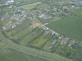
Aldreth is a hamlet
in Cambridgeshire
with about 260 residents (2001 census). It is located near the larger village of Haddenham
and falls under the same Parish council. Aldreth is surrounded by fenland on all sides and the River Great Ouse
, or the Old West as the locals call it, runs close by. Aldreth has no church.
, under the year 1170, and means "Landing-place by the alder
s", from a combination of the Old English words for "alder" and "hythe". The name also occurs a number of times in the text of the 12th century Liber Eliensis
, as "Alreheðe", with one variant as "Alhereðe".
The origin of the name
There are other theories about how Aldreth got its name. Here are the most popular ones:
It may be a derivation of the words Alder Hithe (the old shore), which relates to the Old West river flowing near Aldreth.
It could also come from the words Alder Reche (the old reach), which also relates to the Old West river.
(Saxons
) and William the Conqueror (Normans
). Aldreth was one of three routes, or causeway
s, into the Isle of Ely
at that time; Stuntney
Causeway 2.25 miles (3.6 km) to the south-east, the Earith
Causeway 10 miles (16.1 km) to the west-south-west and the Aldreth Causeway 7 miles (11.3 km) south-west of the Isle of Ely
. For comparison of such causeways, consider the Bronze-Age causeway discovered in 1934 between Little Thetford
and Fordey Farm, Barway
.
(middle-Pleistocene
till
) ridge
sitting on a belt of mainly Jurassic
Kimmerigian
clay
s running south-west from The Wash
. To the east is a north-south running belt of geologically more recent Upper-Cretaceous
Lower Greensand capped by Lower-Cretaceous Gault Clay
; the whole area is surrounded by even more recent fen
deposits. To the west, again running north-east—south-west, is a scarp
belt of middle-Jurassic sedimentary rock
s including limestone
and sandstone
.
The flat fenland countryside around the village, typical for this part of the region, lies about 16 feet (5 m) above sea-level. The highest point in the village is 23 feet (7 m) above sea-level and the highest point in the area is 85 feet (26 m) at Ely, seven-mile (7 miles (11 km)) north-east. In contrast, the highest point in Cambridgeshire, 479 feet (146 m) above sea-level, is at Great Chishill
, 21 miles (34 km) almost due south. Holme
at nine feet (9.02 ft (2.75 m)) below sea-level is East Cambridgeshire's (and the United Kingdom's) lowest point, and is 18 miles (29 km) north-west.
Hamlet (place)
A hamlet is usually a rural settlement which is too small to be considered a village, though sometimes the word is used for a different sort of community. Historically, when a hamlet became large enough to justify building a church, it was then classified as a village...
in Cambridgeshire
Cambridgeshire
Cambridgeshire is a county in England, bordering Lincolnshire to the north, Norfolk to the northeast, Suffolk to the east, Essex and Hertfordshire to the south, and Bedfordshire and Northamptonshire to the west...
with about 260 residents (2001 census). It is located near the larger village of Haddenham
Haddenham, Cambridgeshire
Haddenham is a village and civil parish in Cambridgeshire, England. In the 2001 census the parish had a population of 3,228.It has several shops and a regular bus service to the cathedral city of Ely, which is about north-east of the village....
and falls under the same Parish council. Aldreth is surrounded by fenland on all sides and the River Great Ouse
River Great Ouse
The Great Ouse is a river in the east of England. At long, it is the fourth-longest river in the United Kingdom. The river has been important for navigation, and for draining the low-lying region through which it flows. Its course has been modified several times, with the first recorded being in...
, or the Old West as the locals call it, runs close by. Aldreth has no church.
Blossoms & Bygones
Aldreth shares an annual village open day, Blossoms & Bygones, with neighbouring village Haddenham. Features of the day include tractor rides and vintage car and tractor displays, while many residents throw open their gardens to visitors. Blossoms & Bygones celebrated its 40th Anniversary in 2011 with a VE Day theme, that saw the villagers of Aldreth dress up as if it was 1940. they also by the river have something called geocashing which are good for dog walkers and exploreseThe origin of the name
According to one place-name authority, the name "Aldreth" occurs as "Alreheða" in the Pipe rollsPipe Rolls
The Pipe rolls, sometimes called the Great rolls, are a collection of financial records maintained by the English Exchequer, or Treasury. The earliest date from the 12th century, and the series extends, mostly complete, from then until 1833. They form the oldest continuous series of records kept by...
, under the year 1170, and means "Landing-place by the alder
Alder
Alder is the common name of a genus of flowering plants belonging to the birch family . The genus comprises about 30 species of monoecious trees and shrubs, few reaching large size, distributed throughout the North Temperate Zone and in the Americas along the Andes southwards to...
s", from a combination of the Old English words for "alder" and "hythe". The name also occurs a number of times in the text of the 12th century Liber Eliensis
Liber Eliensis
The Liber Eliensis is a 12th-century English chronicle and history, written in Latin. Composed in three books, it was written at Ely Abbey on the island of Ely in the fenlands of eastern Cambridgeshire. Ely Abbey became the cathedral of a newly formed bishopric in 1109...
, as "Alreheðe", with one variant as "Alhereðe".
The origin of the name
There are other theories about how Aldreth got its name. Here are the most popular ones:
It may be a derivation of the words Alder Hithe (the old shore), which relates to the Old West river flowing near Aldreth.
It could also come from the words Alder Reche (the old reach), which also relates to the Old West river.
Two battles
Aldreth may have been the site of two battles in history between Hereward the WakeHereward the Wake
Hereward the Wake , known in his own times as Hereward the Outlaw or Hereward the Exile, was an 11th-century leader of local resistance to the Norman conquest of England....
(Saxons
Saxons
The Saxons were a confederation of Germanic tribes originating on the North German plain. The Saxons earliest known area of settlement is Northern Albingia, an area approximately that of modern Holstein...
) and William the Conqueror (Normans
Normans
The Normans were the people who gave their name to Normandy, a region in northern France. They were descended from Norse Viking conquerors of the territory and the native population of Frankish and Gallo-Roman stock...
). Aldreth was one of three routes, or causeway
Causeway
In modern usage, a causeway is a road or railway elevated, usually across a broad body of water or wetland.- Etymology :When first used, the word appeared in a form such as “causey way” making clear its derivation from the earlier form “causey”. This word seems to have come from the same source by...
s, into the Isle of Ely
Isle of Ely
The Isle of Ely is a historic region around the city of Ely now in Cambridgeshire, England but previously a county in its own right.-Etymology:...
at that time; Stuntney
Stuntney
-Location:Stuntney is located between Ely and Soham. It is just off the main road going from Newmarket to Ely, the A142.-Archaeology:The region between Devil's Dyke and the line between Littleport and Shippea Hill shows a remarkable amount of archaeological findings of the Stone Age, the Bronze Age...
Causeway 2.25 miles (3.6 km) to the south-east, the Earith
Earith
Earith is a village in the Fens of Cambridgeshire, England, south of Chatteris and east of Huntingdon. At Earith, two artificial diversion channels of the River Great Ouse, the Old Bedford River and the New Bedford River, leave the river on a course to Denver Sluice near Downham Market, where they...
Causeway 10 miles (16.1 km) to the west-south-west and the Aldreth Causeway 7 miles (11.3 km) south-west of the Isle of Ely
Isle of Ely
The Isle of Ely is a historic region around the city of Ely now in Cambridgeshire, England but previously a county in its own right.-Etymology:...
. For comparison of such causeways, consider the Bronze-Age causeway discovered in 1934 between Little Thetford
Little Thetford
Little Thetford is a small village and civil parish south of Ely in Cambridgeshire, England, about by road from London. The village is built on a boulder clay island surrounded by flat fenland countryside, typical of settlements in this part of the East of England...
and Fordey Farm, Barway
Barway
Barway is a small village in Cambridgeshire, England, about three miles south of Ely. It is on Soham Lode, which flows into the River Cam....
.
Geography
Geology
The village is on an east-west running boulder clayBoulder clay
Boulder clay, in geology, is a deposit of clay, often full of boulders, which is formed in and beneath glaciers and ice-sheets wherever they are found, but is in a special sense the typical deposit of the Glacial Period in northern Europe and North America...
(middle-Pleistocene
Pleistocene
The Pleistocene is the epoch from 2,588,000 to 11,700 years BP that spans the world's recent period of repeated glaciations. The name pleistocene is derived from the Greek and ....
till
Till
thumb|right|Closeup of glacial till. Note that the larger grains in the till are completely surrounded by the matrix of finer material , and this characteristic, known as matrix support, is diagnostic of till....
) ridge
Ridge
A ridge is a geological feature consisting of a chain of mountains or hills that form a continuous elevated crest for some distance. Ridges are usually termed hills or mountains as well, depending on size. There are several main types of ridges:...
sitting on a belt of mainly Jurassic
Jurassic
The Jurassic is a geologic period and system that extends from about Mya to Mya, that is, from the end of the Triassic to the beginning of the Cretaceous. The Jurassic constitutes the middle period of the Mesozoic era, also known as the age of reptiles. The start of the period is marked by...
Kimmerigian
Kimmeridge Clay
The Kimmeridge Clay Formation is a sedimentary deposit of fossiliferous marine clay which is of Jurassic age. It occurs in Europe.Kimmeridge Clay is arguably the most economically important unit of rocks in the whole of Europe, being the major source rock for oil fields in the North Sea hydrocarbon...
clay
Clay
Clay is a general term including many combinations of one or more clay minerals with traces of metal oxides and organic matter. Geologic clay deposits are mostly composed of phyllosilicate minerals containing variable amounts of water trapped in the mineral structure.- Formation :Clay minerals...
s running south-west from The Wash
The Wash
The Wash is the square-mouthed bay and estuary on the northwest margin of East Anglia on the east coast of England, where Norfolk meets Lincolnshire. It is among the largest estuaries in the United Kingdom...
. To the east is a north-south running belt of geologically more recent Upper-Cretaceous
Cretaceous
The Cretaceous , derived from the Latin "creta" , usually abbreviated K for its German translation Kreide , is a geologic period and system from circa to million years ago. In the geologic timescale, the Cretaceous follows the Jurassic period and is followed by the Paleogene period of the...
Lower Greensand capped by Lower-Cretaceous Gault Clay
Gault Clay
Gault is a clay formation of stiff blue clay deposited in a calm, fairly deep water marine environment during the Lower Cretaceous Period...
; the whole area is surrounded by even more recent fen
Fen
A fen is a type of wetland fed by mineral-rich surface water or groundwater. Fens are characterised by their water chemistry, which is neutral or alkaline, with relatively high dissolved mineral levels but few other plant nutrients...
deposits. To the west, again running north-east—south-west, is a scarp
Fault scarp
A fault scarp is the topographic expression of faulting attributed to the displacement of the land surface by movement along faults. They are exhibited either by differential movement and subsequent erosion along an old inactive geologic fault , or by a movement on a recent active fault...
belt of middle-Jurassic sedimentary rock
Sedimentary rock
Sedimentary rock are types of rock that are formed by the deposition of material at the Earth's surface and within bodies of water. Sedimentation is the collective name for processes that cause mineral and/or organic particles to settle and accumulate or minerals to precipitate from a solution....
s including limestone
Limestone
Limestone is a sedimentary rock composed largely of the minerals calcite and aragonite, which are different crystal forms of calcium carbonate . Many limestones are composed from skeletal fragments of marine organisms such as coral or foraminifera....
and sandstone
Sandstone
Sandstone is a sedimentary rock composed mainly of sand-sized minerals or rock grains.Most sandstone is composed of quartz and/or feldspar because these are the most common minerals in the Earth's crust. Like sand, sandstone may be any colour, but the most common colours are tan, brown, yellow,...
.
The flat fenland countryside around the village, typical for this part of the region, lies about 16 feet (5 m) above sea-level. The highest point in the village is 23 feet (7 m) above sea-level and the highest point in the area is 85 feet (26 m) at Ely, seven-mile (7 miles (11 km)) north-east. In contrast, the highest point in Cambridgeshire, 479 feet (146 m) above sea-level, is at Great Chishill
Great Chishill
Great Chishill is a village forming part of the civil parish of Great and Little Chishill in the south of the county of Cambridgeshire. The church is in the Perpendicular style and is dedicated to Swithun....
, 21 miles (34 km) almost due south. Holme
Holme, Cambridgeshire
Holme is a village in Huntingdonshire , England, near Conington and Yaxley, and south of Peterborough.- The village :...
at nine feet (9.02 ft (2.75 m)) below sea-level is East Cambridgeshire's (and the United Kingdom's) lowest point, and is 18 miles (29 km) north-west.