
A7 road
Encyclopedia
The A7 is a major trunk road
in the United Kingdom
, that runs south from Edinburgh
in Central Scotland
to Carlisle in North West England
.
The road then goes past Cameron Toll
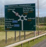
, and then meeting at the Edinburgh City Bypass at the notorious Sheriffhall Roundabout that also leads to Musselburgh and Dalkeith via the A6106
, Glasgow
and Livingston via the M8, Kilmarnock
via the A71, Perth
and Stirling via the M9 and M90
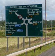
, and Newcastle via the A68, and also the A1 at the bypass' eastern terminus where it heads towards the city centre and the south.
 After passing the City Bypass, the A7 continues on through the four Eskbank bypasses (B6392, A772 (the former A7), A768 and the A6094) and makes its way past a series of small towns and villages; Newtongrange, Gorebridge and Middleton Moor.
, twisting past the villages of Heriot
, Fountainhall, and Stow and then passing towards Galashiels
, becoming part of the town's ring road, also joining the A72
via the town's northern ring road.
The A7 becomes a trunk road
at the junction on the A6091
(A68) roundabout just outside Galashiels, then continuing onto the small town of Selkirk. The part of the road between Selkirk and Hawick
has lots of realigned stretches, allowing for overtaking. When the A7 reaches Hawick, it avoids the town centre, instead meeting the A698 at the leisure centre. The road then continues along the north bank of the River Teviot
to the Sandbed roundabout, from which it then leaves the town.
After leaving Hawick, the A7 carries on through the countryside and enters Dumfries and Galloway
towards Langholm
, where the two longest B roads in the UK meet; the B709 and B6318, then bypassing Canonbie
, which the A7 used to go through and is now called the B7201.
, before meeting the A689
and the M6
at the Greymoorhill Roundabout, which is also junction 44 of the M6, the second last junction before the motorway joins the A74(M) just before the Scottish border.
Beyond Greymoorhill roundabout, the A7 becomes a brief dual carriageway
, close to the Kingstown Industrial Estate on the northern fringe of Carlisle. Continuing as a busy single carriageway road, the A7 goes past several main supermarket
s, and crosses the River Eden
over Eden Bridge.
At Hardwicke Circus Roundabout, a large junction in the centre of Carlisle, the A7 meets the A595
to the west and southern Cumbria and then continues to form part of Carlisle's one way system through the city centre, meeting the A69 and finally becoming the A6 near Carlisle railway station
.
The A7 is unique in that it is the only single number A-road in the United Kingdom that does not have a parallel motorway as there is no motorway called the 'M7'.
Trunk road
A trunk road, trunk highway, or strategic road is a major road—usually connecting two or more cities, ports, airports, and other things.—which is the recommended route for long-distance and freight traffic...
in the United Kingdom
United Kingdom
The United Kingdom of Great Britain and Northern IrelandIn the United Kingdom and Dependencies, other languages have been officially recognised as legitimate autochthonous languages under the European Charter for Regional or Minority Languages...
, that runs south from Edinburgh
Edinburgh
Edinburgh is the capital city of Scotland, the second largest city in Scotland, and the eighth most populous in the United Kingdom. The City of Edinburgh Council governs one of Scotland's 32 local government council areas. The council area includes urban Edinburgh and a rural area...
in Central Scotland
Central Scotland
Central Scotland may refer to:* Central Belt, the area of highest population density in Scotland, also known as the "Midlands" or "Scottish Midlands"* Central Lowlands, a geologically-defined area of relatively low-lying land in southern Scotland...
to Carlisle in North West England
North West England
North West England, informally known as The North West, is one of the nine official regions of England.North West England had a 2006 estimated population of 6,853,201 the third most populated region after London and the South East...
.
Edinburgh
The A7 begins its course in central Edinburgh, at the A1/A7/A8/A900 junction at North Bridge as a non-trunk road before passing through the city's south-eastern suburbs. This part of the A7 was the former route of the A68 (the old A7 used to be what is now the A701/A772 at Gilmerton).The road then goes past Cameron Toll
Cameron Toll
Cameron Toll is a suburb located to the south of Edinburgh, Scotland.Originally it was the site of a toll house built in the early 19th century, which was located on a stretch of road between Edinburgh and Dalkeith...
, and then meeting at the Edinburgh City Bypass at the notorious Sheriffhall Roundabout that also leads to Musselburgh and Dalkeith via the A6106
A roads in Zone 6 of the Great Britain numbering scheme
List of A roads in zone 6 in Great Britain starting east of the A6 and A7 roads and west of the A1 .-Single- and double-digit roads:-Triple-digit roads:-Four-digit roads :-Four-digit roads :...
, Glasgow
Glasgow
Glasgow is the largest city in Scotland and third most populous in the United Kingdom. The city is situated on the River Clyde in the country's west central lowlands...
and Livingston via the M8, Kilmarnock
Kilmarnock
Kilmarnock is a large burgh in East Ayrshire, Scotland, with a population of 44,734. It is the second largest town in Ayrshire. The River Irvine runs through its eastern section, and the Kilmarnock Water passes through it, giving rise to the name 'Bank Street'...
via the A71, Perth
Perth, Scotland
Perth is a town and former city and royal burgh in central Scotland. Located on the banks of the River Tay, it is the administrative centre of Perth and Kinross council area and the historic county town of Perthshire...
and Stirling via the M9 and M90
M90 motorway
The M90 is a motorway in Scotland. It runs from Inverkeithing, at the north end of the Forth Road Bridge, to Perth, passing Dunfermline, Cowdenbeath and Kinross on the way...
, and Newcastle via the A68, and also the A1 at the bypass' eastern terminus where it heads towards the city centre and the south.
The Scottish Borders
After travelling through the villages of Midlothian, the A7 then enters through the region of the Scottish BordersScottish Borders
The Scottish Borders is one of 32 local government council areas of Scotland. It is bordered by Dumfries and Galloway in the west, South Lanarkshire and West Lothian in the north west, City of Edinburgh, East Lothian, Midlothian to the north; and the non-metropolitan counties of Northumberland...
, twisting past the villages of Heriot
Heriot, Scotland
Heriot is a small village in the Moorfoot Hills southeast of Edinburgh, Scotland, within Eildon . The village comprises some 150 dwellings, spread over a geographical area of around , most of which is moorland...
, Fountainhall, and Stow and then passing towards Galashiels
Galashiels
Galashiels is a burgh in the Scottish Borders, on the Gala Water river. The name is often shortened to "Gala" .Galashiels is a major commercial centre for the Scottish Borders...
, becoming part of the town's ring road, also joining the A72
A72 road
The A72 is a major route in Scotland connecting Hamilton in South Lanarkshire, with Galashiels in the Scottish Borders.It travels for over 60 miles in a South-Easterly direction, along the Clyde and Tweed valleys, passing the towns of Larkhall, Lanark, Biggar and Peebles.-Hamilton to...
via the town's northern ring road.
The A7 becomes a trunk road
Trunk road
A trunk road, trunk highway, or strategic road is a major road—usually connecting two or more cities, ports, airports, and other things.—which is the recommended route for long-distance and freight traffic...
at the junction on the A6091
A roads in Zone 6 of the Great Britain numbering scheme
List of A roads in zone 6 in Great Britain starting east of the A6 and A7 roads and west of the A1 .-Single- and double-digit roads:-Triple-digit roads:-Four-digit roads :-Four-digit roads :...
(A68) roundabout just outside Galashiels, then continuing onto the small town of Selkirk. The part of the road between Selkirk and Hawick
Hawick
Hawick is a town in the Scottish Borders of south east Scotland. It is south-west of Jedburgh and south-southeast of Selkirk. It is one of the farthest towns from the sea in Scotland, in the heart of Teviotdale, and the biggest town in the former county of Roxburghshire. Hawick's architecture is...
has lots of realigned stretches, allowing for overtaking. When the A7 reaches Hawick, it avoids the town centre, instead meeting the A698 at the leisure centre. The road then continues along the north bank of the River Teviot
River Teviot
The River Teviot, or Teviot Water, is a river of the Scottish Borders area of Scotland, and a tributary of the River Tweed.It rises in the western foothills of Comb Hill on the border of Dumfries and Galloway...
to the Sandbed roundabout, from which it then leaves the town.
After leaving Hawick, the A7 carries on through the countryside and enters Dumfries and Galloway
Dumfries and Galloway
Dumfries and Galloway is one of 32 unitary council areas of Scotland. It was one of the nine administrative 'regions' of mainland Scotland created in 1975 by the Local Government etc. Act 1973...
towards Langholm
Langholm
Langholm , also known colloquially as the "Muckle Toon", is a burgh in Dumfries and Galloway, Scotland, on the River Esk and the A7 road.- History:...
, where the two longest B roads in the UK meet; the B709 and B6318, then bypassing Canonbie
Canonbie
Canonbie is a small village in Dumfries and Galloway in south west Scotland, six miles south of Langholm and two miles north of the Anglo-Scottish border. It is on the A7 road from Carlisle to Edinburgh, and the River Esk flows through it...
, which the A7 used to go through and is now called the B7201.
Auchenrivock Realignment
The A7 was realigned through the area of Auchenrivock, just to the south of Langholm. The new road, which opened in 2009, has cut journey times between Langholm and Canonbie as well as improving overtaking opportunities. The upgrade contains two junctions which allow local access to Auchenrivock. The remains of the old A7 are now part of a cycle route.Entering England
Continuing past the English border, the A7 goes through the small town of LongtownLongtown, Cumbria
Longtown is a small town in northern Cumbria, England, with a population of around 3,000. It is in the parish of Arthuret and on the River Esk, not far from the Anglo-Scottish border. Nearby was the Battle of Arfderydd....
, before meeting the A689
A689 road
The A689 is a road in northern England, that runs east from Junction 44 of the M6 motorway, north of the centre of Carlisle in Cumbria, to Hartlepool, in the North East....
and the M6
M6 motorway
The M6 motorway runs from junction 19 of the M1 at the Catthorpe Interchange, near Rugby via Birmingham then heads north, passing Stoke-on-Trent, Manchester, Preston, Carlisle and terminating at the Gretna junction . Here, just short of the Scottish border it becomes the A74 which continues to...
at the Greymoorhill Roundabout, which is also junction 44 of the M6, the second last junction before the motorway joins the A74(M) just before the Scottish border.
Beyond Greymoorhill roundabout, the A7 becomes a brief dual carriageway
Dual carriageway
A dual carriageway is a class of highway with two carriageways for traffic travelling in opposite directions separated by a central reservation...
, close to the Kingstown Industrial Estate on the northern fringe of Carlisle. Continuing as a busy single carriageway road, the A7 goes past several main supermarket
Supermarket
A supermarket, a form of grocery store, is a self-service store offering a wide variety of food and household merchandise, organized into departments...
s, and crosses the River Eden
River Eden, Cumbria
The River Eden is a river that flows through Cumbria, England on its way to the Solway Firth.-Course of river:The Eden rises in Black Fell Moss, Mallerstang, on the high ground between High Seat, Yorkshire Dales and Hugh Seat. Here it forms the boundary between the counties of Cumbria and North...
over Eden Bridge.
At Hardwicke Circus Roundabout, a large junction in the centre of Carlisle, the A7 meets the A595
A595 road
The A595 is a primary route in Cumbria, in northern England that starts in Carlisle, passes through Whitehaven, and goes close to Workington, Cockermouth and Wigton. It passes Sellafield and Ravenglass before ending at the Dalton-in-Furness by-pass, in southern Cumbria, where it joins the A590...
to the west and southern Cumbria and then continues to form part of Carlisle's one way system through the city centre, meeting the A69 and finally becoming the A6 near Carlisle railway station
Carlisle railway station
Carlisle railway station, also known as Carlisle Citadel station, is a railway station whichserves the Cumbrian City of Carlisle, England, and is a major station on the West Coast Main Line, lying south of Glasgow Central, and north of London Euston...
.
The A7 is unique in that it is the only single number A-road in the United Kingdom that does not have a parallel motorway as there is no motorway called the 'M7'.