
2006-07 South Pacific cyclone season
Encyclopedia
The 2006–07 South Pacific cyclone season was an event in the annual cycle of tropical cyclone
formation. It began on November 1, 2006 and ended on April 30, 2007. These dates conventionally delimit the period of each year when most tropical cyclones form in the southern Pacific Ocean east of 160°E
. Additionally, the regional tropical cyclone operational plan defines a tropical cyclone year separately from a tropical cyclone season, and the "tropical cyclone year" runs from July 1, 2006 to June 30, 2007.
Tropical cyclones between 160°E
and 120°W
and north of 25°S
are monitored by the Fiji Meteorological Service
in Nadi
. Those that move south of 25°S
are monitored by the Tropical Cyclone Warning Centre in Wellington
, New Zealand.
The 2006–07 South Pacific cyclone season got off to an early start with a tropical disturbance developing into Cyclone Xavier
, late on October 21. Xavier rapidly intensified
and became a category three Severe Tropical Cyclone on the Australian tropical cyclone intensity scale during the next day. As a Severe Tropical Cyclone, Xavier passed over Tikopia and then continued to intensify and reached its peak wind speeds early on October 24. Xavier then rapidly weakened during the next day which led to the final advisories being issued on October 26. Whilst Xavier was active, Tropical Depression 02F formed on October 24 to the northeast of American Samoa
. As the depression moved towards the west, it remained weak as it was badly affected by Cyclone Xavier's outflow, the final advisory was released on October 29. Early on November 1, Tropical Disturbance 03F formed to the northeast of Fiji. It was then upgraded to a Tropical Depression later that day. The depression then meandered around the International dateline for a couple days without any significant development, with the final advisory being issued by RSMC Nadi early on November 3. Cyclone Yani formed as a weak tropical disturbance on November 16, it was upgraded into Tropical Depression 04F early the next day. Over the next few days the depression moved towards the west gradually developing until a Tropical Cyclone Formation Alert
was issued late on November 21. Early the next day it was upgraded to Cyclone Yali by RSMC Nadi and designated as 02P by the JTWC, after being classified Yani started to intensify quite quickly becoming a Category three severe tropical cyclone early on November 23. Yali then reached its peak windspeeds later that day before starting to rapidly weaken early on November 24, as it entered an area of higher wind shear and was downgraded to a Tropical Depression later that day.
to the north of the system remained weak. The final advisory was then issued on October 29 by RSMC Nadi as the depression had completely dissipated.
. The disturbance did not have any organised convection near the low level circulation centre and was located in an area of low vertical wind shear. Early the next day whilst the organisation of the system had not improved much, there had been enough of an increase in convection in the northern and southern quadrants for RSMC Nadi to designate the disturbance as Tropical Depression 04F. Over the next couple of days the depression gradually moved towards the south-west before the low level circulation center was relocated to the north of Vanuatu early on November 19. The depression continued to gradually develop, with a Tropical Cyclone Formation Alert being issued late on November 21 as convection had erupted about the low level circulation centre with bands of convection wrapping around the low level circulation significantly.
The depression was then upgraded to a category one tropical cyclone on the Australian Tropical Cyclone Intensity scale early on November 22, with the name Yani being assigned. The JTWC also upgraded Yani to a tropical cyclone whilst the cyclone was located approximately 425 km, (265 miles), to the southeast of Honiara
, in the Solomon Islands
. Yani then intensified fairly rapidly, being upgraded to a category two cyclone later that day while an eye was noted to be beginning to form. Yani was then upgraded to a category three severe tropical cyclone early the next day as the developing eye had established itself well. Later that day, Yani then reached its peak pressure of 960 hPa and its peak windspeeds of 140 km/h (85 mph) (10-min) and 130 km/h (80 mph) (1-min). Yani maintained its peak intensity until early on November 24, when the storm began to weaken under the force of strengthening shear that tore away its low level circulation centre and was downgraded to a Tropical Depression by RSMC Nadi later that day. The JTWC then issued their final advisory early the next day whilst RSMC Nadi kept issuing advisories until late on November 26 as the depression moved into TCWC Brisbane's area of responsibility. The JTWC later reported that it had dissipated that day.
on November 28. RSMC Nadi began monitoring it as a tropical disturbance early on November 29 as it moved westward in a favorable environment for development. The disturbance later that day was classified as a tropical depression. On November 30, the Joint Typhoon Warning Center
initiated advisories on the storm, internally numbered Tropical Cyclone 04P. Under heavy wind shear
, the storm never developed further and the JTWC stopped advisories on December 1, shortly after RSMC Nadi.
, located in a sheared environment, with convection having persisted for 24 hours. It never developed further and late on January 15 RSMC Nadi noted that 06F had become extratropical. RSMC Nadi last noted it two days later.
marine bulletin identified a tropical disturbance east of the International Date Line
. The low level circulation center was unidentifiable but was estimated to be at the southwestern edge of the major convection. On January 18, RSMC Nadi identified the disturbance as a tropical depression while the system was still poorly organized. On January 20, the Joint Typhoon Warning Center
noted the system and treated it as a tropical disturbance. On January 22, the JTWC issued a Tropical Cyclone Formation Alert
on the system. The system was assigned the name Zita by RSMC Nadi and commented in their tropical disturbance summary that the cyclone had undergone explosive development. It then quickly began extratropical
transition as it moved south-southeast, with the JTWC declaring it extratropical on January 24. It entered the warning area of TCWC Wellington later that day as it passed south of 25°S
, and completed extratropical transition early on January 25.
into a strong Category 2 cyclone on the Australian intensity scale according to the Regional Specialized Meteorological Centre
in Nadi, Fiji. The Joint Typhoon Warning Center
assessed the storm to have peaked as a minimal Category 1 cyclone. Shortly after peaking in intensity, the cyclone began to deteriorate due to unfavorable conditions. Quickly moving towards the east-southeast, the Arthur began to undergo an extratropical transition
. After turning towards the southeast, the center of circulation was almost fully exposed due to strong wind shear
. However, Arthur briefly re-strengthened late on January 26 before becoming extratropical the next day. Tropical Cyclone Arthur affected several small islands during its existence. French Polynesia
observed the most noteworthy effects from the storm, where several landslides damaged a few homes.
east of the International Date Line
on January 30. On February 2, RSMC Nadi upgraded it to a tropical depression, and the next day, the Joint Typhoon Warning Center
issued a Tropical Cyclone Formation Alert
. On February 4, the JTWC upgraded the disturbance to a tropical cyclone, giving it the designation 11P. However, it quickly became extratropical, and the final warning was issued just 24 hours later. RSMC Nadi also stopped tracking the low on February 5.
on March 19 and moved southeast over the next three days with little change in organisation. On March 21, the system began to increase in organization, and RSMC Nadi
designated the system Tropical Depression 12F late that day, noting that the potential for development into a tropical cyclone was low to moderate due to increasing wind shear
to the south. The Joint Typhoon Warning Center
issued a Tropical Cyclone Formation Alert
on the now-quasi-stationary system the next day. RSMC Nadi upgraded the potential for development to high and began issuing advisories later in the day, but the depression soon became disorganised due to increasing shear. The RSMC issued its last advisory early on March 25.
on March 24. The Tropical Cyclone Warning Centre in Brisbane
began monitoring it as a tropical low early on March 25, before it moved eastward into the area of responsibility of RSMC Nadi
later that day. RSMC Nadi designated the system Tropical Depression 13F and noted that it had a moderate potential for development into a tropical cyclone. Tropical disturbance advisories were initiated on March 26 as the system improved in organisation. The Joint Typhoon Warning Center
designated it Tropical Cyclone 21P later that day. RSMC Nadi followed suit and upgraded the system to a tropical cyclone and named it Becky.
Becky initially strengthened quickly while moving south-southeastward, nearly reaching hurricane-equivalent intensity on March 27. RSMC Nadi initially issued a storm warning
for Vanuatu, but the environment began to deteriorate, inhibiting any further strengthening. The cyclone began weakening late that day as it passed to the west of Vanuatu, and RSMC Nadi issued its final tropical disturbance advisory on Becky early on March 29.
just west of the date line, was first warned on by RSMC Nadi on April 1 as a sheared system located in a highly-sheared environment. Despite this, the system managed to organise and intensify as it moved southeast, and was named Tropical Cyclone Cliff on April 4 near the international date line
. The Joint Typhoon Warning Center
designated it a tropical cyclone, the 23rd in the Southern Hemisphere
for the season, later that day, as deep convective banding began to develop. Continuing to move generally southeast, Cliff peaked in intensity on April 5 before starting to weaken as it crossed into the area of responsibility of TCWC Wellington. Late that night, Cliff started to show signs of extratropical transition, causing Dvorak
satellite intensity estimates to fall. The JTWC issued its final advisory the next day, followed later that day by TCWC Wellington as it completed transition.
Tropical cyclone
A tropical cyclone is a storm system characterized by a large low-pressure center and numerous thunderstorms that produce strong winds and heavy rain. Tropical cyclones strengthen when water evaporated from the ocean is released as the saturated air rises, resulting in condensation of water vapor...
formation. It began on November 1, 2006 and ended on April 30, 2007. These dates conventionally delimit the period of each year when most tropical cyclones form in the southern Pacific Ocean east of 160°E
160th meridian east
The meridian 160° east of Greenwich is a line of longitude that extends from the North Pole across the Arctic Ocean, Asia, the Pacific Ocean, the Southern Ocean, and Antarctica to the South Pole....
. Additionally, the regional tropical cyclone operational plan defines a tropical cyclone year separately from a tropical cyclone season, and the "tropical cyclone year" runs from July 1, 2006 to June 30, 2007.
Tropical cyclones between 160°E
160th meridian east
The meridian 160° east of Greenwich is a line of longitude that extends from the North Pole across the Arctic Ocean, Asia, the Pacific Ocean, the Southern Ocean, and Antarctica to the South Pole....
and 120°W
120th meridian west
The meridian 120° west of Greenwich is a line of longitude that extends from the North Pole across the Arctic Ocean, North America, the Pacific Ocean, the Southern Ocean, and Antarctica to the South Pole....
and north of 25°S
25th parallel south
The 25th parallel south is a circle of latitude that is 25 degrees south of the Earth's equatorial plane, just south of the Tropic of Capricorn...
are monitored by the Fiji Meteorological Service
Fiji Meteorological Service
The Fiji Meteorological Service is a Department of the government of Fiji responsible for providing weather forecasts and is based in Nadi. Since 1995, FMS has been responsible for naming and tracking tropical cyclones in the Southwest Pacific region...
in Nadi
Nadi
Nadi is the third-largest conurbation in Fiji. It is located on the western side of the main island of Viti Levu, and had a population of 42,284 at the most recent census, in 2007. Nadi is multiracial with many of its inhabitants Indian or Fijian, along with a large transient population of foreign...
. Those that move south of 25°S
25th parallel south
The 25th parallel south is a circle of latitude that is 25 degrees south of the Earth's equatorial plane, just south of the Tropic of Capricorn...
are monitored by the Tropical Cyclone Warning Centre in Wellington
Wellington
Wellington is the capital city and third most populous urban area of New Zealand, although it is likely to have surpassed Christchurch due to the exodus following the Canterbury Earthquake. It is at the southwestern tip of the North Island, between Cook Strait and the Rimutaka Range...
, New Zealand.
Seasonal outlooks
| Source/Record | Season/Date | TC Tropical cyclone A tropical cyclone is a storm system characterized by a large low-pressure center and numerous thunderstorms that produce strong winds and heavy rain. Tropical cyclones strengthen when water evaporated from the ocean is released as the saturated air rises, resulting in condensation of water vapor... |
STC | Ref |
| Average | (1969-70 – 2005-06) | 9.0 | 4.5 | |
| Record high activity | 1997-98 | 17 | 7 | |
| Record low activity | 2003–04/1994–95 | 3 | 1 | |
| Activity during the season | 6 | 2 |
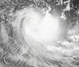
The 2006–07 South Pacific cyclone season got off to an early start with a tropical disturbance developing into Cyclone Xavier
Cyclone Xavier (2006)
Severe Tropical Cyclone Xavier was a strong pre-season cyclone, that formed on October 20 to the north of the Santa Cruz Islands...
, late on October 21. Xavier rapidly intensified
Rapid deepening
Rapid deepening, also known as rapid intensification, is a meteorological condition that occurs when the minimum sea-level atmospheric pressure of a tropical cyclone decreases drastically in a short period of time. The National Weather Service describes rapid deepening as a decrease of...
and became a category three Severe Tropical Cyclone on the Australian tropical cyclone intensity scale during the next day. As a Severe Tropical Cyclone, Xavier passed over Tikopia and then continued to intensify and reached its peak wind speeds early on October 24. Xavier then rapidly weakened during the next day which led to the final advisories being issued on October 26. Whilst Xavier was active, Tropical Depression 02F formed on October 24 to the northeast of American Samoa
American Samoa
American Samoa is an unincorporated territory of the United States located in the South Pacific Ocean, southeast of the sovereign state of Samoa...
. As the depression moved towards the west, it remained weak as it was badly affected by Cyclone Xavier's outflow, the final advisory was released on October 29. Early on November 1, Tropical Disturbance 03F formed to the northeast of Fiji. It was then upgraded to a Tropical Depression later that day. The depression then meandered around the International dateline for a couple days without any significant development, with the final advisory being issued by RSMC Nadi early on November 3. Cyclone Yani formed as a weak tropical disturbance on November 16, it was upgraded into Tropical Depression 04F early the next day. Over the next few days the depression moved towards the west gradually developing until a Tropical Cyclone Formation Alert
Tropical Cyclone Formation Alert
A Tropical Cyclone Formation Alert is a bulletin released by the U.S. Navy-operated Joint Typhoon Warning Center in Honolulu, Hawaii or the Naval Maritime Forecast Center in Norfolk, Virginia, warning of the possibility of a tropical cyclone forming from a tropical disturbance that has been...
was issued late on November 21. Early the next day it was upgraded to Cyclone Yali by RSMC Nadi and designated as 02P by the JTWC, after being classified Yani started to intensify quite quickly becoming a Category three severe tropical cyclone early on November 23. Yali then reached its peak windspeeds later that day before starting to rapidly weaken early on November 24, as it entered an area of higher wind shear and was downgraded to a Tropical Depression later that day.
Severe Tropical Cyclone Xavier
On October 20 a weak tropical disturbance formed to the north of the Santa Cruz Islands. During the next day it rapidly developed and was designated as Tropical Cyclone Xavier whilst over Santa Cruz later that day. During the next day, Xavier rapidly intensified into a category three severe tropical cyclone before passing over Tikopia early the next day. Xavier then reached its peak wind speeds of 175 km/h (110 mph) (10-min), 215 km/h (130 mph) (1-min) which made it a Category four cyclone early on October 24. Xavier stayed at its peak wind speeds until early the next day when it started to rapidly weaken becoming a Depression early on October 26. The remants of the depression were then tracked by RSMC Nadi until early on October 28 when they couldn’t be identified anymore. There were no casualties reported as a result of Cyclone Xavier, with very little impact reported in the Solomon Islands and Vanuatu.Tropical Depression 02F
Late on October 24, RSMC Nadi reported that Tropical Depression 02F had formed embedded in an easterly trough about 555 km (344.9 mi), to the northwest of American Samoa. Deep convection had persisted around the center however it was poorly organised with multiple low level circulation centers being reported with environmental shear around the system minimal. During the next day as it moved towards the west and crossed the international dateline the depression lost all its deep convection. The low level circulation center had become difficult to locate as the depression was being influenced unfavorably by the outflow from Cyclone Xavier. As a result of the outflow the depression became separated from the southeasterly surge which had been helping to develop the system whilst the westerliesWesterlies
The Westerlies, anti-trades, or Prevailing Westerlies, are the prevailing winds in the middle latitudes between 30 and 60 degrees latitude, blowing from the high pressure area in the horse latitudes towards the poles. These prevailing winds blow from the west to the east, and steer extratropical...
to the north of the system remained weak. The final advisory was then issued on October 29 by RSMC Nadi as the depression had completely dissipated.
Tropical Depression 03F
Early on November 1, RSMC Nadi reported that Tropical Disturbance 03F, had developed to the northeast of Fiji, with multiple circulation centers. Later that day as the convection was now displaced to the north of the low level circulation center and the disturbance had become better organized it was designated as a tropical depression. The system then meandered around in the same general area for a couple days without any development until the final advisory was issued by RSMC Nadi early on November 3.Severe Tropical Cyclone Yani
Late on November 16 a weak tropical disturbance formed to the north-west of Tuvalu embedded within the South Pacific Convergence ZoneSouth Pacific convergence zone
The South Pacific Convergence Zone , a reverse-oriented monsoon trough, is a band of low-level convergence, cloudiness and precipitation extending from the west Pacific warm pool south-eastwards towards French Polynesia...
. The disturbance did not have any organised convection near the low level circulation centre and was located in an area of low vertical wind shear. Early the next day whilst the organisation of the system had not improved much, there had been enough of an increase in convection in the northern and southern quadrants for RSMC Nadi to designate the disturbance as Tropical Depression 04F. Over the next couple of days the depression gradually moved towards the south-west before the low level circulation center was relocated to the north of Vanuatu early on November 19. The depression continued to gradually develop, with a Tropical Cyclone Formation Alert being issued late on November 21 as convection had erupted about the low level circulation centre with bands of convection wrapping around the low level circulation significantly.
The depression was then upgraded to a category one tropical cyclone on the Australian Tropical Cyclone Intensity scale early on November 22, with the name Yani being assigned. The JTWC also upgraded Yani to a tropical cyclone whilst the cyclone was located approximately 425 km, (265 miles), to the southeast of Honiara
Honiara
Honiara, population 49,107 , 78,190 , is the capital of the Solomon Islands and of Guadalcanal Province, although it is a separately administered town...
, in the Solomon Islands
Solomon Islands
Solomon Islands is a sovereign state in Oceania, east of Papua New Guinea, consisting of nearly one thousand islands. It covers a land mass of . The capital, Honiara, is located on the island of Guadalcanal...
. Yani then intensified fairly rapidly, being upgraded to a category two cyclone later that day while an eye was noted to be beginning to form. Yani was then upgraded to a category three severe tropical cyclone early the next day as the developing eye had established itself well. Later that day, Yani then reached its peak pressure of 960 hPa and its peak windspeeds of 140 km/h (85 mph) (10-min) and 130 km/h (80 mph) (1-min). Yani maintained its peak intensity until early on November 24, when the storm began to weaken under the force of strengthening shear that tore away its low level circulation centre and was downgraded to a Tropical Depression by RSMC Nadi later that day. The JTWC then issued their final advisory early the next day whilst RSMC Nadi kept issuing advisories until late on November 26 as the depression moved into TCWC Brisbane's area of responsibility. The JTWC later reported that it had dissipated that day.
Tropical Depression 05F
An area of disturbed weather developed east-northeast of the Solomon IslandsSolomon Islands
Solomon Islands is a sovereign state in Oceania, east of Papua New Guinea, consisting of nearly one thousand islands. It covers a land mass of . The capital, Honiara, is located on the island of Guadalcanal...
on November 28. RSMC Nadi began monitoring it as a tropical disturbance early on November 29 as it moved westward in a favorable environment for development. The disturbance later that day was classified as a tropical depression. On November 30, the Joint Typhoon Warning Center
Joint Typhoon Warning Center
The Joint Typhoon Warning Center is a joint United States Navy – United States Air Force task force located at the Naval Maritime Forecast Center in Pearl Harbor, Hawaii...
initiated advisories on the storm, internally numbered Tropical Cyclone 04P. Under heavy wind shear
Wind shear
Wind shear, sometimes referred to as windshear or wind gradient, is a difference in wind speed and direction over a relatively short distance in the atmosphere...
, the storm never developed further and the JTWC stopped advisories on December 1, shortly after RSMC Nadi.
Tropical Depression 06F
On January 9 RSMC Nadi identified a tropical depression well east of the International Date LineInternational Date Line
The International Date Line is a generally north-south imaginary line on the surface of the Earth, passing through the middle of the Pacific Ocean, that designates the place where each calendar day begins...
, located in a sheared environment, with convection having persisted for 24 hours. It never developed further and late on January 15 RSMC Nadi noted that 06F had become extratropical. RSMC Nadi last noted it two days later.
Tropical Cyclone Zita
On January 16 a RSMC NadiFiji Meteorological Service
The Fiji Meteorological Service is a Department of the government of Fiji responsible for providing weather forecasts and is based in Nadi. Since 1995, FMS has been responsible for naming and tracking tropical cyclones in the Southwest Pacific region...
marine bulletin identified a tropical disturbance east of the International Date Line
International Date Line
The International Date Line is a generally north-south imaginary line on the surface of the Earth, passing through the middle of the Pacific Ocean, that designates the place where each calendar day begins...
. The low level circulation center was unidentifiable but was estimated to be at the southwestern edge of the major convection. On January 18, RSMC Nadi identified the disturbance as a tropical depression while the system was still poorly organized. On January 20, the Joint Typhoon Warning Center
Joint Typhoon Warning Center
The Joint Typhoon Warning Center is a joint United States Navy – United States Air Force task force located at the Naval Maritime Forecast Center in Pearl Harbor, Hawaii...
noted the system and treated it as a tropical disturbance. On January 22, the JTWC issued a Tropical Cyclone Formation Alert
Tropical Cyclone Formation Alert
A Tropical Cyclone Formation Alert is a bulletin released by the U.S. Navy-operated Joint Typhoon Warning Center in Honolulu, Hawaii or the Naval Maritime Forecast Center in Norfolk, Virginia, warning of the possibility of a tropical cyclone forming from a tropical disturbance that has been...
on the system. The system was assigned the name Zita by RSMC Nadi and commented in their tropical disturbance summary that the cyclone had undergone explosive development. It then quickly began extratropical
Extratropical cyclone
Extratropical cyclones, sometimes called mid-latitude cyclones or wave cyclones, are a group of cyclones defined as synoptic scale low pressure weather systems that occur in the middle latitudes of the Earth having neither tropical nor polar characteristics, and are connected with fronts and...
transition as it moved south-southeast, with the JTWC declaring it extratropical on January 24. It entered the warning area of TCWC Wellington later that day as it passed south of 25°S
25th parallel south
The 25th parallel south is a circle of latitude that is 25 degrees south of the Earth's equatorial plane, just south of the Tropic of Capricorn...
, and completed extratropical transition early on January 25.
Tropical Cyclone Arthur
Forming as tropical depression on January 25, Arthur rapidly intensifiedRapid deepening
Rapid deepening, also known as rapid intensification, is a meteorological condition that occurs when the minimum sea-level atmospheric pressure of a tropical cyclone decreases drastically in a short period of time. The National Weather Service describes rapid deepening as a decrease of...
into a strong Category 2 cyclone on the Australian intensity scale according to the Regional Specialized Meteorological Centre
Regional Specialized Meteorological Centre
A Regional Specialized Meteorological Centre is responsible for the distribution of information, advisories, and warnings regarding the specific program they have a part of, agreed by consensus at the World Meteorological Organization as part of the World Weather Watch.-Tropical...
in Nadi, Fiji. The Joint Typhoon Warning Center
Joint Typhoon Warning Center
The Joint Typhoon Warning Center is a joint United States Navy – United States Air Force task force located at the Naval Maritime Forecast Center in Pearl Harbor, Hawaii...
assessed the storm to have peaked as a minimal Category 1 cyclone. Shortly after peaking in intensity, the cyclone began to deteriorate due to unfavorable conditions. Quickly moving towards the east-southeast, the Arthur began to undergo an extratropical transition
Extratropical cyclone
Extratropical cyclones, sometimes called mid-latitude cyclones or wave cyclones, are a group of cyclones defined as synoptic scale low pressure weather systems that occur in the middle latitudes of the Earth having neither tropical nor polar characteristics, and are connected with fronts and...
. After turning towards the southeast, the center of circulation was almost fully exposed due to strong wind shear
Wind shear
Wind shear, sometimes referred to as windshear or wind gradient, is a difference in wind speed and direction over a relatively short distance in the atmosphere...
. However, Arthur briefly re-strengthened late on January 26 before becoming extratropical the next day. Tropical Cyclone Arthur affected several small islands during its existence. French Polynesia
French Polynesia
French Polynesia is an overseas country of the French Republic . It is made up of several groups of Polynesian islands, the most famous island being Tahiti in the Society Islands group, which is also the most populous island and the seat of the capital of the territory...
observed the most noteworthy effects from the storm, where several landslides damaged a few homes.
Tropical Depression 09F
RSMC Nadi noted a tropical disturbance in the general area of 10°S10th parallel south
The 10th parallel south is a circle of latitude that is 10 degrees south of the Earth's equatorial plane. It crosses the Atlantic Ocean, Africa, the Indian Ocean, Australasia, the Pacific Ocean and South America....
east of the International Date Line
International Date Line
The International Date Line is a generally north-south imaginary line on the surface of the Earth, passing through the middle of the Pacific Ocean, that designates the place where each calendar day begins...
on January 30. On February 2, RSMC Nadi upgraded it to a tropical depression, and the next day, the Joint Typhoon Warning Center
Joint Typhoon Warning Center
The Joint Typhoon Warning Center is a joint United States Navy – United States Air Force task force located at the Naval Maritime Forecast Center in Pearl Harbor, Hawaii...
issued a Tropical Cyclone Formation Alert
Tropical Cyclone Formation Alert
A Tropical Cyclone Formation Alert is a bulletin released by the U.S. Navy-operated Joint Typhoon Warning Center in Honolulu, Hawaii or the Naval Maritime Forecast Center in Norfolk, Virginia, warning of the possibility of a tropical cyclone forming from a tropical disturbance that has been...
. On February 4, the JTWC upgraded the disturbance to a tropical cyclone, giving it the designation 11P. However, it quickly became extratropical, and the final warning was issued just 24 hours later. RSMC Nadi also stopped tracking the low on February 5.
Tropical Depression 12F
An area of disturbed weather formed northwest of FijiFiji
Fiji , officially the Republic of Fiji , is an island nation in Melanesia in the South Pacific Ocean about northeast of New Zealand's North Island...
on March 19 and moved southeast over the next three days with little change in organisation. On March 21, the system began to increase in organization, and RSMC Nadi
Fiji Meteorological Service
The Fiji Meteorological Service is a Department of the government of Fiji responsible for providing weather forecasts and is based in Nadi. Since 1995, FMS has been responsible for naming and tracking tropical cyclones in the Southwest Pacific region...
designated the system Tropical Depression 12F late that day, noting that the potential for development into a tropical cyclone was low to moderate due to increasing wind shear
Wind shear
Wind shear, sometimes referred to as windshear or wind gradient, is a difference in wind speed and direction over a relatively short distance in the atmosphere...
to the south. The Joint Typhoon Warning Center
Joint Typhoon Warning Center
The Joint Typhoon Warning Center is a joint United States Navy – United States Air Force task force located at the Naval Maritime Forecast Center in Pearl Harbor, Hawaii...
issued a Tropical Cyclone Formation Alert
Tropical Cyclone Formation Alert
A Tropical Cyclone Formation Alert is a bulletin released by the U.S. Navy-operated Joint Typhoon Warning Center in Honolulu, Hawaii or the Naval Maritime Forecast Center in Norfolk, Virginia, warning of the possibility of a tropical cyclone forming from a tropical disturbance that has been...
on the now-quasi-stationary system the next day. RSMC Nadi upgraded the potential for development to high and began issuing advisories later in the day, but the depression soon became disorganised due to increasing shear. The RSMC issued its last advisory early on March 25.
Tropical Cyclone Becky
An area of disturbed weather formed northwest of VanuatuVanuatu
Vanuatu , officially the Republic of Vanuatu , is an island nation located in the South Pacific Ocean. The archipelago, which is of volcanic origin, is some east of northern Australia, northeast of New Caledonia, west of Fiji, and southeast of the Solomon Islands, near New Guinea.Vanuatu was...
on March 24. The Tropical Cyclone Warning Centre in Brisbane
Brisbane
Brisbane is the capital and most populous city in the Australian state of Queensland and the third most populous city in Australia. Brisbane's metropolitan area has a population of over 2 million, and the South East Queensland urban conurbation, centred around Brisbane, encompasses a population of...
began monitoring it as a tropical low early on March 25, before it moved eastward into the area of responsibility of RSMC Nadi
Fiji Meteorological Service
The Fiji Meteorological Service is a Department of the government of Fiji responsible for providing weather forecasts and is based in Nadi. Since 1995, FMS has been responsible for naming and tracking tropical cyclones in the Southwest Pacific region...
later that day. RSMC Nadi designated the system Tropical Depression 13F and noted that it had a moderate potential for development into a tropical cyclone. Tropical disturbance advisories were initiated on March 26 as the system improved in organisation. The Joint Typhoon Warning Center
Joint Typhoon Warning Center
The Joint Typhoon Warning Center is a joint United States Navy – United States Air Force task force located at the Naval Maritime Forecast Center in Pearl Harbor, Hawaii...
designated it Tropical Cyclone 21P later that day. RSMC Nadi followed suit and upgraded the system to a tropical cyclone and named it Becky.
Becky initially strengthened quickly while moving south-southeastward, nearly reaching hurricane-equivalent intensity on March 27. RSMC Nadi initially issued a storm warning
Storm warning
At sea, a storm warning is a warning issued by the National Weather Service of the United States when winds between 48 knots and 63 knots are occurring or predicted to occur soon. The winds must not be associated with a tropical cyclone...
for Vanuatu, but the environment began to deteriorate, inhibiting any further strengthening. The cyclone began weakening late that day as it passed to the west of Vanuatu, and RSMC Nadi issued its final tropical disturbance advisory on Becky early on March 29.
Tropical Cyclone Cliff
Tropical Depression 14F, located around 15°S15th parallel south
The 15th parallel south is a circle of latitude that is 15 degrees south of the Earth's equatorial plane. It crosses the Atlantic Ocean, Africa, the Indian Ocean, Australasia, the Pacific Ocean and South America....
just west of the date line, was first warned on by RSMC Nadi on April 1 as a sheared system located in a highly-sheared environment. Despite this, the system managed to organise and intensify as it moved southeast, and was named Tropical Cyclone Cliff on April 4 near the international date line
International Date Line
The International Date Line is a generally north-south imaginary line on the surface of the Earth, passing through the middle of the Pacific Ocean, that designates the place where each calendar day begins...
. The Joint Typhoon Warning Center
Joint Typhoon Warning Center
The Joint Typhoon Warning Center is a joint United States Navy – United States Air Force task force located at the Naval Maritime Forecast Center in Pearl Harbor, Hawaii...
designated it a tropical cyclone, the 23rd in the Southern Hemisphere
Southern Hemisphere
The Southern Hemisphere is the part of Earth that lies south of the equator. The word hemisphere literally means 'half ball' or "half sphere"...
for the season, later that day, as deep convective banding began to develop. Continuing to move generally southeast, Cliff peaked in intensity on April 5 before starting to weaken as it crossed into the area of responsibility of TCWC Wellington. Late that night, Cliff started to show signs of extratropical transition, causing Dvorak
Dvorak technique
The Dvorak technique is a widely used system to subjectively estimate tropical cyclone intensity based solely on visible and infrared satellite images. Several agencies issue Dvorak intensity numbers for cyclones of sufficient intensity...
satellite intensity estimates to fall. The JTWC issued its final advisory the next day, followed later that day by TCWC Wellington as it completed transition.
Season effects
See also
- List of Southern Hemisphere tropical cyclone seasons
- Atlantic hurricane seasons: 20062006 Atlantic hurricane seasonThe 2006 Atlantic hurricane season was significantly less active than the record previous season. It marked the first since 2001 in which no hurricanes made landfall in the United States, and was the first since 1994 that no tropical cyclones formed during October. Following the intense activity of...
, 20072007 Atlantic hurricane seasonThe 2007 Atlantic hurricane season was an active Atlantic hurricane season that produced 17 tropical cyclones, 15 tropical storms, six hurricanes, and two major hurricanes. It officially started on June 1 and ended on November 30, dates which conventionally delimit the... - Pacific hurricane seasons: 20062006 Pacific hurricane seasonThe 2006 Pacific hurricane season was the most active Pacific hurricane season since 2000 producing 19 tropical storms or hurricanes. Eighteen developed within the National Hurricane Center area of warning responsibility, which is east of 140ºW, and one storm formed between 140ºW and the...
, 20072007 Pacific hurricane seasonThe 2007 Pacific hurricane season was an event in the annual cycle of tropical cyclone formation. It officially started on May 15, 2007 in the eastern Pacific, designated as the area east of 140°W, and on June 1, 2007 in the central Pacific, which is between the International Date Line and 140°W,... - Pacific typhoon seasons: 20062006 Pacific typhoon seasonThe 2006 Pacific typhoon season had no official bounds; it ran year-round in 2006, but most tropical cyclones tend to form in the northwestern Pacific Ocean between May and November...
, 20072007 Pacific typhoon seasonThe 2007 Pacific typhoon season was a below average season which featured 24 named storms and 14 typhoons, compared to the average of 27 and 17 respectively. had no official bounds; it ran year-round in 2007, but most tropical cyclones tend to form in the northwestern Pacific Ocean between May and... - North Indian Ocean cyclone seasons: 2006, 2007