
1947 Atlantic hurricane season
Encyclopedia
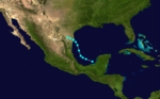
The 1947 Atlantic hurricane season officially began on June 16, 1947, and lasted until November 1, 1947. These dates conventionally delimit the period of each year when most tropical cyclone
s form in the Atlantic basin
.
The 1947 hurricane season
was a fairly active one in terms of landfalling storms. A Category 2
hit near Tampico
, a Category 1 hit near Galveston
, and a Category 1 hit near the Georgia
/South Carolina
border. The most significant storm by far, however, was the Fort Lauderdale Hurricane
which struck Fort Lauderdale
as a Category 4 hurricane
, then made a second landfall in Louisiana
.
/United States
border on August 2. It dissipated that day after causing $2 million in damage (1947 dollars), mostly crop damage from flooding.
. It moved west-northwest, hitting near Cozumel, Mexico on August 12. As it moved through the Bay of Campeche
, it quickly strengthened to a peak of 110 mph (180 km/h) winds, and hit just south of Tampico, Mexico on August 15. The hurricane dissipated the next day over land, causing 19 fatalities.
on August 22, steadily strengthening to an 80 mph (130 km/h) Category 1 hurricane
before making landfall near Galveston, Texas
on the September 24. Hurricane Three resulted in $200,000 in damage, as well as one death.
west of the Saint Petersburg/Tampa
area on September 7. The short-lived tropical storm peaked at 45 mi/h before weakening to a depression the following day and making landfall just southwest of Mobile
on September 8. The system dissipated shortly thereafter.
on September 17. It moved across the Gulf of Mexico as a weakened hurricane, but restrengthened before striking eastern Louisiana
on September 19 as a Category 3 hurricane
. The hurricane caused $110 million in damage (1947 dollars) and 51 casualties. Although it was very powerful at its Florida landfall, its destruction was less severe than previous tropical cyclone
s in the 1920s.
on September 20. It headed northwestward, hitting Cuba
on September 22. The storm turned north-northeastward over the Gulf of Mexico, strengthening to a 60 mi/h tropical storm before hitting near Cedar Key
on September 24. The storm became extratropical later that day, after causing tornadic activity amounting to $100,000 in damage (1947 US dollars).
on October 7. It looped over Georgia
and Florida, and dissipated on October 8.
on October 8. The low then drifted northward where it became a tropical storm the next day. The tropical storm then passed over the western tip of Cuba
, producing a peak wind gust of 57 mph (92 km/h). The storm strengthened over the southeastern Gulf of Mexico
to attain hurricane status on October 11, and after brushing the Florida Keys
before making landfall near Cape Sable, Florida on October 12. The hurricane moved offshore near Pompano Beach
and later reached a peak intensity of 85 mph (135 km/h) in the western Atlantic
before turning back to the west. On October 15, the hurricane made its final landfall near the Georgia/South Carolina
border, and dissipated 24 hours later. The storm was unofficially known as Hurricane King.
An airport in south Florida
recorded peak winds of 80 mph (130 km/h). The hurricane dropped 5-13 (12.7–33 cm) inches of rain across central and southern part of the state, including in Hialeah
where the storm produced 3.6 inches (7.6 cm) in a one hour period and over 6 inches (15.2 cm) in a 75 minute period. The flooding rains left many neighborhoods in up to six feet of water due to a previously wet summer, and left over 2,000 Miami-Dade County
residents homeless. The flooding also closed U.S. 1
from Miami
to Fort Lauderdale
, as well as a highway to Everglades City. The hurricane spawned a tornado in both Coral Gables
and Miami, one of which destroyed three warehouses. In all, the hurricane caused $27.5 million dollars (1947 USD, $260 million 2005 USD) in damage in Florida. Following the passage of the hurricane, Hialeah mayor Henry Milander declared a state of emergency and restricted access to the city. In Miami, many residents had to use boats and rafts to survey damage and look for survivors, due to the flooding. Winds in Georgia
peaked at 85 mph (135 km/h) in Savannah
, where the storm caused $20 million dollars (1947 USD, $189 million 2005 USD) in damage. Elsewhere in Georgia, the storm caused $500,000 (1947 USD, $4.7 million 2005 USD) in damage, mainly due to a tornado that touched down near Hinesville
. Tides twelve feet above normal were reported from Georgia to South Carolina
. In Charleston, South Carolina
, the high tides caused minor beach erosion and isolated street flooding, and one person was killed there by a falling tree. In North Carolina
, the high tides caused minor flooding.
The hurricane was noted for the first time hurricane seeding was conducted in the Atlantic basin
by the United States Weather Bureau through an operation called Project Cirrus
. A B-17 dropped 80 pounds (36.3 kg) of dry ice
onto the storm from 500 feet above its cloudtop after it had moved 350 miles off Jacksonville. Shortly afterward, the storm reversed course and headed for Savannah. The scientists conducting the experiment believed they had caused this change, but it was shown a 1906 hurricane
had followed a similar pattern.
and strengthening to hurricane status while beginning a gradual curve to the northeast. Hurricane Love was the first storm flown at low-levels by the 53rd Reconnaissance Squadron. The storm reached its peak intensity as a 120 mph (195 km/h) Category 3 hurricane
just west of Bermuda
, bringing winds estimated at 100 mph (175 km/h) to the island. The storm continued northeast and became extratropical on October 22.
The table on the right shows the ACE
for each storm in the season. ACE is, broadly speaking, a measure of the power of the hurricane multiplied by the length of time it existed, so storms that last a long time, as well as particularly strong hurricanes, have high ACEs. ACE is only officially released for full advisories on tropical systems at or exceeding (34 knots (66.6 km/h) or tropical storm strength. Subtropical storms are not included in season totals.
Tropical cyclone
A tropical cyclone is a storm system characterized by a large low-pressure center and numerous thunderstorms that produce strong winds and heavy rain. Tropical cyclones strengthen when water evaporated from the ocean is released as the saturated air rises, resulting in condensation of water vapor...
s form in the Atlantic basin
Atlantic Basin
The Atlantic Basin is the Atlantic Ocean.Atlantic Basin may also refer to:* Atlantic Basin Iron Works, an ironworks that operated in Brooklyn, New York, in the early to mid-20th century...
.
The 1947 hurricane season
Atlantic hurricane season
The Atlantic hurricane season is the period in a year when hurricanes usually form in the Atlantic Ocean. Tropical cyclones in the North Atlantic are called hurricanes, tropical storms, or tropical depressions. In addition, there have been several storms over the years that have not been fully...
was a fairly active one in terms of landfalling storms. A Category 2
Saffir-Simpson Hurricane Scale
The Saffir–Simpson Hurricane Scale , or the Saffir–Simpson Hurricane Wind Scale , classifies hurricanes — Western Hemisphere tropical cyclones that exceed the intensities of tropical depressions and tropical storms — into five categories distinguished by the intensities of their sustained winds...
hit near Tampico
Tampico
Tampico is a city and port in the state of Tamaulipas, in the country of Mexico. It is located in the southeastern part of the state, directly north across the border from Veracruz. Tampico is the third largest city in Tamaulipas, and counts with a population of 309,003. The Metropolitan area of...
, a Category 1 hit near Galveston
Galveston, Texas
Galveston is a coastal city located on Galveston Island in the U.S. state of Texas. , the city had a total population of 47,743 within an area of...
, and a Category 1 hit near the Georgia
Georgia (U.S. state)
Georgia is a state located in the southeastern United States. It was established in 1732, the last of the original Thirteen Colonies. The state is named after King George II of Great Britain. Georgia was the fourth state to ratify the United States Constitution, on January 2, 1788...
/South Carolina
South Carolina
South Carolina is a state in the Deep South of the United States that borders Georgia to the south, North Carolina to the north, and the Atlantic Ocean to the east. Originally part of the Province of Carolina, the Province of South Carolina was one of the 13 colonies that declared independence...
border. The most significant storm by far, however, was the Fort Lauderdale Hurricane
1947 Fort Lauderdale Hurricane
The Fort Lauderdale Hurricane was an intense Category 5 hurricane that affected the Bahamas, Florida, Louisiana, and Mississippi in September of the 1947 Atlantic hurricane season...
which struck Fort Lauderdale
Fort Lauderdale, Florida
Fort Lauderdale is a city in the U.S. state of Florida, on the Atlantic coast. It is the county seat of Broward County. As of the 2010 census, the city had a population of 165,521. It is a principal city of the South Florida metropolitan area, which was home to 5,564,635 people at the 2010...
as a Category 4 hurricane
Saffir-Simpson Hurricane Scale
The Saffir–Simpson Hurricane Scale , or the Saffir–Simpson Hurricane Wind Scale , classifies hurricanes — Western Hemisphere tropical cyclones that exceed the intensities of tropical depressions and tropical storms — into five categories distinguished by the intensities of their sustained winds...
, then made a second landfall in Louisiana
Louisiana
Louisiana is a state located in the southern region of the United States of America. Its capital is Baton Rouge and largest city is New Orleans. Louisiana is the only state in the U.S. with political subdivisions termed parishes, which are local governments equivalent to counties...
.
Tropical Storm One
A weak tropical storm moving northwest across the Gulf of Mexico hit just south of the MexicoMexico
The United Mexican States , commonly known as Mexico , is a federal constitutional republic in North America. It is bordered on the north by the United States; on the south and west by the Pacific Ocean; on the southeast by Guatemala, Belize, and the Caribbean Sea; and on the east by the Gulf of...
/United States
United States
The United States of America is a federal constitutional republic comprising fifty states and a federal district...
border on August 2. It dissipated that day after causing $2 million in damage (1947 dollars), mostly crop damage from flooding.
Hurricane Two
On August 9, a tropical storm formed in the Caribbean SeaCaribbean Sea
The Caribbean Sea is a sea of the Atlantic Ocean located in the tropics of the Western hemisphere. It is bounded by Mexico and Central America to the west and southwest, to the north by the Greater Antilles, and to the east by the Lesser Antilles....
. It moved west-northwest, hitting near Cozumel, Mexico on August 12. As it moved through the Bay of Campeche
Bay of Campeche
The Bay of Campeche is the southern bight of the Gulf of Mexico. It is surrounded on three sides by the Mexican states of Campeche, Tabasco and Veracruz. It was named by Francisco Hernández de Córdoba and Antonio de Alaminos during their expedition in 1517...
, it quickly strengthened to a peak of 110 mph (180 km/h) winds, and hit just south of Tampico, Mexico on August 15. The hurricane dissipated the next day over land, causing 19 fatalities.
Tropical Storm Three
A tropical wave became a tropical storm over the Florida Straits on August 18. It headed west-northward, producing a 3.6 feet (1.1 m) storm surge as it passed off shore of Grand Isle, LouisianaGrand Isle, Louisiana
Grand Isle is a town in Jefferson Parish, Louisiana, located on a barrier island of the same name in the Gulf of Mexico. The island is at the mouth of Barataria Bay where it meets the gulf. As of the 2000 census, the town population was 1,541; during summers, the population sometimes increases to...
on August 22, steadily strengthening to an 80 mph (130 km/h) Category 1 hurricane
Saffir-Simpson Hurricane Scale
The Saffir–Simpson Hurricane Scale , or the Saffir–Simpson Hurricane Wind Scale , classifies hurricanes — Western Hemisphere tropical cyclones that exceed the intensities of tropical depressions and tropical storms — into five categories distinguished by the intensities of their sustained winds...
before making landfall near Galveston, Texas
Galveston, Texas
Galveston is a coastal city located on Galveston Island in the U.S. state of Texas. , the city had a total population of 47,743 within an area of...
on the September 24. Hurricane Three resulted in $200,000 in damage, as well as one death.
Tropical Storm Five
A weak tropical storm formed in the northeastern Gulf of MexicoGulf of Mexico
The Gulf of Mexico is a partially landlocked ocean basin largely surrounded by the North American continent and the island of Cuba. It is bounded on the northeast, north and northwest by the Gulf Coast of the United States, on the southwest and south by Mexico, and on the southeast by Cuba. In...
west of the Saint Petersburg/Tampa
Tampa, Florida
Tampa is a city in the U.S. state of Florida. It serves as the county seat for Hillsborough County. Tampa is located on the west coast of Florida. The population of Tampa in 2010 was 335,709....
area on September 7. The short-lived tropical storm peaked at 45 mi/h before weakening to a depression the following day and making landfall just southwest of Mobile
Mobile, Alabama
Mobile is the third most populous city in the Southern US state of Alabama and is the county seat of Mobile County. It is located on the Mobile River and the central Gulf Coast of the United States. The population within the city limits was 195,111 during the 2010 census. It is the largest...
on September 8. The system dissipated shortly thereafter.
Hurricane George
This storm was named George by the Weather Bureau office in Miami, which worked in conjunction with the military at that time. This powerful hurricane hit near Fort Lauderdale, FloridaFort Lauderdale, Florida
Fort Lauderdale is a city in the U.S. state of Florida, on the Atlantic coast. It is the county seat of Broward County. As of the 2010 census, the city had a population of 165,521. It is a principal city of the South Florida metropolitan area, which was home to 5,564,635 people at the 2010...
on September 17. It moved across the Gulf of Mexico as a weakened hurricane, but restrengthened before striking eastern Louisiana
Louisiana
Louisiana is a state located in the southern region of the United States of America. Its capital is Baton Rouge and largest city is New Orleans. Louisiana is the only state in the U.S. with political subdivisions termed parishes, which are local governments equivalent to counties...
on September 19 as a Category 3 hurricane
Saffir-Simpson Hurricane Scale
The Saffir–Simpson Hurricane Scale , or the Saffir–Simpson Hurricane Wind Scale , classifies hurricanes — Western Hemisphere tropical cyclones that exceed the intensities of tropical depressions and tropical storms — into five categories distinguished by the intensities of their sustained winds...
. The hurricane caused $110 million in damage (1947 dollars) and 51 casualties. Although it was very powerful at its Florida landfall, its destruction was less severe than previous tropical cyclone
Tropical cyclone
A tropical cyclone is a storm system characterized by a large low-pressure center and numerous thunderstorms that produce strong winds and heavy rain. Tropical cyclones strengthen when water evaporated from the ocean is released as the saturated air rises, resulting in condensation of water vapor...
s in the 1920s.
Tropical Storm Seven
A tropical wave developed into a tropical storm over western JamaicaJamaica
Jamaica is an island nation of the Greater Antilles, in length, up to in width and 10,990 square kilometres in area. It is situated in the Caribbean Sea, about south of Cuba, and west of Hispaniola, the island harbouring the nation-states Haiti and the Dominican Republic...
on September 20. It headed northwestward, hitting Cuba
Cuba
The Republic of Cuba is an island nation in the Caribbean. The nation of Cuba consists of the main island of Cuba, the Isla de la Juventud, and several archipelagos. Havana is the largest city in Cuba and the country's capital. Santiago de Cuba is the second largest city...
on September 22. The storm turned north-northeastward over the Gulf of Mexico, strengthening to a 60 mi/h tropical storm before hitting near Cedar Key
Cedar Key, Florida
Cedar Key is a city in Levy County, Florida, United States. The population was 790 at the 2000 census. According to the U.S Census estimates of 2005, the city had a population of 958. The Cedar Keys are a cluster of islands close to the mainland. Most of the developed area of the city has been on...
on September 24. The storm became extratropical later that day, after causing tornadic activity amounting to $100,000 in damage (1947 US dollars).
Tropical Storm Eight
On October 6, a tropical wave formed into a tropical storm over the Bahamas. It moved rapidly north-northwestward, and hit near Brunswick, GeorgiaBrunswick, Georgia
Brunswick is the major urban and economic center in southeastern Georgia in the United States. The municipality is located on a harbor near the Atlantic Ocean, approximately 30 miles north of Florida and 70 miles south of South Carolina. Brunswick is bordered on the east by the Atlantic...
on October 7. It looped over Georgia
Georgia (U.S. state)
Georgia is a state located in the southeastern United States. It was established in 1732, the last of the original Thirteen Colonies. The state is named after King George II of Great Britain. Georgia was the fourth state to ratify the United States Constitution, on January 2, 1788...
and Florida, and dissipated on October 8.
Hurricane Nine
A tropical low was detected off the coast of NicaraguaNicaragua
Nicaragua is the largest country in the Central American American isthmus, bordered by Honduras to the north and Costa Rica to the south. The country is situated between 11 and 14 degrees north of the Equator in the Northern Hemisphere, which places it entirely within the tropics. The Pacific Ocean...
on October 8. The low then drifted northward where it became a tropical storm the next day. The tropical storm then passed over the western tip of Cuba
Cuba
The Republic of Cuba is an island nation in the Caribbean. The nation of Cuba consists of the main island of Cuba, the Isla de la Juventud, and several archipelagos. Havana is the largest city in Cuba and the country's capital. Santiago de Cuba is the second largest city...
, producing a peak wind gust of 57 mph (92 km/h). The storm strengthened over the southeastern Gulf of Mexico
Gulf of Mexico
The Gulf of Mexico is a partially landlocked ocean basin largely surrounded by the North American continent and the island of Cuba. It is bounded on the northeast, north and northwest by the Gulf Coast of the United States, on the southwest and south by Mexico, and on the southeast by Cuba. In...
to attain hurricane status on October 11, and after brushing the Florida Keys
Florida Keys
The Florida Keys are a coral archipelago in southeast United States. They begin at the southeastern tip of the Florida peninsula, about south of Miami, and extend in a gentle arc south-southwest and then westward to Key West, the westernmost of the inhabited islands, and on to the uninhabited Dry...
before making landfall near Cape Sable, Florida on October 12. The hurricane moved offshore near Pompano Beach
Pompano Beach, Florida
Pompano Beach ) is a city in Broward County, Florida, along the coast of the Atlantic Ocean just to the north of Fort Lauderdale. The nearby Hillsboro Inlet forms part of the Atlantic Intracoastal Waterway. As of the 2010 census, the city's population was 99,845...
and later reached a peak intensity of 85 mph (135 km/h) in the western Atlantic
Atlantic Ocean
The Atlantic Ocean is the second-largest of the world's oceanic divisions. With a total area of about , it covers approximately 20% of the Earth's surface and about 26% of its water surface area...
before turning back to the west. On October 15, the hurricane made its final landfall near the Georgia/South Carolina
South Carolina
South Carolina is a state in the Deep South of the United States that borders Georgia to the south, North Carolina to the north, and the Atlantic Ocean to the east. Originally part of the Province of Carolina, the Province of South Carolina was one of the 13 colonies that declared independence...
border, and dissipated 24 hours later. The storm was unofficially known as Hurricane King.
An airport in south Florida
Florida
Florida is a state in the southeastern United States, located on the nation's Atlantic and Gulf coasts. It is bordered to the west by the Gulf of Mexico, to the north by Alabama and Georgia and to the east by the Atlantic Ocean. With a population of 18,801,310 as measured by the 2010 census, it...
recorded peak winds of 80 mph (130 km/h). The hurricane dropped 5-13 (12.7–33 cm) inches of rain across central and southern part of the state, including in Hialeah
Hialeah, Florida
Hialeah is a city in Miami-Dade County, Florida, United States. As of the 2000 census, the city population was 226,419. As of 2009, the population estimate by the U. S...
where the storm produced 3.6 inches (7.6 cm) in a one hour period and over 6 inches (15.2 cm) in a 75 minute period. The flooding rains left many neighborhoods in up to six feet of water due to a previously wet summer, and left over 2,000 Miami-Dade County
Miami-Dade County, Florida
Miami-Dade County is a county located in the southeastern part of the state of Florida. As of 2010 U.S. Census, the county had a population of 2,496,435, making it the most populous county in Florida and the eighth-most populous county in the United States...
residents homeless. The flooding also closed U.S. 1
U.S. Route 1 in Florida
U.S. Route 1 in Florida runs along the state's east coast from Key West to its crossing of the St. Marys River into Georgia north of Boulogne, and south of Folkston. US 1 was designated through Florida when the U.S. Highway System was established in 1926.US 1 runs in the state of Florida, and...
from Miami
Miami, Florida
Miami is a city located on the Atlantic coast in southeastern Florida and the county seat of Miami-Dade County, the most populous county in Florida and the eighth-most populous county in the United States with a population of 2,500,625...
to Fort Lauderdale
Fort Lauderdale, Florida
Fort Lauderdale is a city in the U.S. state of Florida, on the Atlantic coast. It is the county seat of Broward County. As of the 2010 census, the city had a population of 165,521. It is a principal city of the South Florida metropolitan area, which was home to 5,564,635 people at the 2010...
, as well as a highway to Everglades City. The hurricane spawned a tornado in both Coral Gables
Coral Gables, Florida
Coral Gables is a city in Miami-Dade County, Florida, southwest of Downtown Miami, in the United States. The city is home to the University of Miami....
and Miami, one of which destroyed three warehouses. In all, the hurricane caused $27.5 million dollars (1947 USD, $260 million 2005 USD) in damage in Florida. Following the passage of the hurricane, Hialeah mayor Henry Milander declared a state of emergency and restricted access to the city. In Miami, many residents had to use boats and rafts to survey damage and look for survivors, due to the flooding. Winds in Georgia
Georgia (U.S. state)
Georgia is a state located in the southeastern United States. It was established in 1732, the last of the original Thirteen Colonies. The state is named after King George II of Great Britain. Georgia was the fourth state to ratify the United States Constitution, on January 2, 1788...
peaked at 85 mph (135 km/h) in Savannah
Savannah, Georgia
Savannah is the largest city and the county seat of Chatham County, in the U.S. state of Georgia. Established in 1733, the city of Savannah was the colonial capital of the Province of Georgia and later the first state capital of Georgia. Today Savannah is an industrial center and an important...
, where the storm caused $20 million dollars (1947 USD, $189 million 2005 USD) in damage. Elsewhere in Georgia, the storm caused $500,000 (1947 USD, $4.7 million 2005 USD) in damage, mainly due to a tornado that touched down near Hinesville
Hinesville, Georgia
Hinesville is a city in Liberty County, Georgia, United States. The population was 30,392 at the 2000 census. Hinesville is also known to have been the home of three signers of the Declaration of Independence: Lyman Hall, George Walton and Button Gwinnett. The city is the county seat of Liberty...
. Tides twelve feet above normal were reported from Georgia to South Carolina
South Carolina
South Carolina is a state in the Deep South of the United States that borders Georgia to the south, North Carolina to the north, and the Atlantic Ocean to the east. Originally part of the Province of Carolina, the Province of South Carolina was one of the 13 colonies that declared independence...
. In Charleston, South Carolina
Charleston, South Carolina
Charleston is the second largest city in the U.S. state of South Carolina. It was made the county seat of Charleston County in 1901 when Charleston County was founded. The city's original name was Charles Towne in 1670, and it moved to its present location from a location on the west bank of the...
, the high tides caused minor beach erosion and isolated street flooding, and one person was killed there by a falling tree. In North Carolina
North Carolina
North Carolina is a state located in the southeastern United States. The state borders South Carolina and Georgia to the south, Tennessee to the west and Virginia to the north. North Carolina contains 100 counties. Its capital is Raleigh, and its largest city is Charlotte...
, the high tides caused minor flooding.
The hurricane was noted for the first time hurricane seeding was conducted in the Atlantic basin
Atlantic Basin
The Atlantic Basin is the Atlantic Ocean.Atlantic Basin may also refer to:* Atlantic Basin Iron Works, an ironworks that operated in Brooklyn, New York, in the early to mid-20th century...
by the United States Weather Bureau through an operation called Project Cirrus
Project Stormfury
Project Stormfury was an attempt to weaken tropical cyclones by flying aircraft into them and seeding with silver iodide. The project was run by the United States Government from 1962 to 1983....
. A B-17 dropped 80 pounds (36.3 kg) of dry ice
Dry ice
Dry ice, sometimes referred to as "Cardice" or as "card ice" , is the solid form of carbon dioxide. It is used primarily as a cooling agent. Its advantages include lower temperature than that of water ice and not leaving any residue...
onto the storm from 500 feet above its cloudtop after it had moved 350 miles off Jacksonville. Shortly afterward, the storm reversed course and headed for Savannah. The scientists conducting the experiment believed they had caused this change, but it was shown a 1906 hurricane
1906 Florida Keys hurricane
The 1906 Florida Keys hurricane was a powerful and deadly hurricane that caused major impacts in Cuba and southern Florida. The fifth hurricane and third major hurricane of the season, the storm formed from a system near Barbados on October 4. By October 8, it had intensified into a tropical storm,...
had followed a similar pattern.
Hurricane Love
This storm developed on October 16 over the Leeward Islands as a tropical storm. It moved northwest, bypassing Puerto RicoPuerto Rico
Puerto Rico , officially the Commonwealth of Puerto Rico , is an unincorporated territory of the United States, located in the northeastern Caribbean, east of the Dominican Republic and west of both the United States Virgin Islands and the British Virgin Islands.Puerto Rico comprises an...
and strengthening to hurricane status while beginning a gradual curve to the northeast. Hurricane Love was the first storm flown at low-levels by the 53rd Reconnaissance Squadron. The storm reached its peak intensity as a 120 mph (195 km/h) Category 3 hurricane
Saffir-Simpson Hurricane Scale
The Saffir–Simpson Hurricane Scale , or the Saffir–Simpson Hurricane Wind Scale , classifies hurricanes — Western Hemisphere tropical cyclones that exceed the intensities of tropical depressions and tropical storms — into five categories distinguished by the intensities of their sustained winds...
just west of Bermuda
Bermuda
Bermuda is a British overseas territory in the North Atlantic Ocean. Located off the east coast of the United States, its nearest landmass is Cape Hatteras, North Carolina, about to the west-northwest. It is about south of Halifax, Nova Scotia, Canada, and northeast of Miami, Florida...
, bringing winds estimated at 100 mph (175 km/h) to the island. The storm continued northeast and became extratropical on October 22.
Accumulated Cyclone Energy (ACE) rating
| ACE (104kt²) (Source) — Storm: | |||||||||||||
|---|---|---|---|---|---|---|---|---|---|---|---|---|---|
| 1 | 62.6025 | Four 1947 Fort Lauderdale Hurricane The Fort Lauderdale Hurricane was an intense Category 5 hurricane that affected the Bahamas, Florida, Louisiana, and Mississippi in September of the 1947 Atlantic hurricane season... |
6 | 3.1 | Six | ||||||||
| 2 | 13.7575 | Nine | 7 | 1.3 | One | ||||||||
| 3 | 10.925 | Eight | 8 | 0.89 | Seven | ||||||||
| 4 | 10.03 | Two | 9 | 0.6025 | Five | ||||||||
| 5 | 9.19 | Three | |||||||||||
| Total: 112.3975 | |||||||||||||
The table on the right shows the ACE
Accumulated cyclone energy
Accumulated cyclone energy is a measure used by the National Oceanic and Atmospheric Administration to express the activity of individual tropical cyclones and entire tropical cyclone seasons, particularly the North Atlantic hurricane season. It uses an approximation of the energy used by a...
for each storm in the season. ACE is, broadly speaking, a measure of the power of the hurricane multiplied by the length of time it existed, so storms that last a long time, as well as particularly strong hurricanes, have high ACEs. ACE is only officially released for full advisories on tropical systems at or exceeding (34 knots (66.6 km/h) or tropical storm strength. Subtropical storms are not included in season totals.
See also
- List of tropical cyclones
- List of Atlantic hurricane seasons