

1692 Jamaica earthquake
Encyclopedia
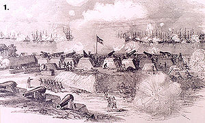
The 1692 Jamaica earthquake struck Port Royal
, Jamaica
on June 7, at exactly 11:43 a.m., according to a stopped pocket watch found in the harbour in the 1950s. Port Royal was then the unofficial capital of Jamaica, and one of the busiest and wealthiest ports in the West Indies. It was known both as the "storehouse and treasury of the West Indies" and "one of the wickedest places on earth". The earthquake caused most of the city to sink below sea level and about 2,000 people died as a result of the earthquake and the following tsunami. About 3000 people died in the days following the earthquakes due to injuries and disease.
and the Gonâve Microplate
. The Gonâve microplate is a 1100 km (683.5 mi) long strip of mainly oceanic crust
formed by the Cayman spreading ridge within a strike-slip pull apart basin
on the northern transform margin of the caribbean plate with the North American Plate
. Jamaica was formed by uplift associated with a restraining bend along this strike-slip structure. The focal mechanism
s of earthquakes around Jamaica are primarily sinistral strike-slip along WSW-ENE trending faults and minor reverse or thrust motion on NW-SE trending faults. The 1692 event is thought to have occurred on one of these strike-slip faults.
 Two-thirds of the town, amounting to 33 acres (13.4 ha), sank into the sea immediately after the main shock. According to Robert Renny in his 'An History of Jamaica' (1807) "All the wharves sunk at once, and in the space of two minutes, nine-tenths of the city were covered with water, which was raised to such a height, that it entered the uppermost rooms of the few houses which were left standing. The tops of the highest houses, were visible in the water, and surrounded by the masts of vessels, which had been sunk along with them".
Before the earthquake, the town consisted of 6,500 inhabitants living in about 2,000 buildings, many constructed of brick and with more than one storey, and all built on loose sand. During the shaking, the sand liquefied
and the buildings, along with their occupants, appeared to flow into the sea. More than twenty ships moored in the harbour were capsized. One ship, the frigate
Swan, was carried over the rooftops by the tsunami.
During the mainshock the sand was said to have formed waves. Fissures repeatedly opened and closed, crushing many people. After the shaking stopped, the sand again solidified, trapping many victims.
At Liguanea (present Kingston
), all the houses were destroyed and water was ejected from 40 feet (12.2 m) wells. Almost all the houses at St. Jago (Spanish Town
) were also destroyed.
There were many landslides throughout the island. The largest, the Judgement Cliff landslide, displaced the land surface by up to 800 m and killed 19 people. Several rivers were temporarily dammed and a few days after the earthquakes the harbour became flooded with large numbers of trees stripped of their bark brought down after one of these dams was breached.
A pocket watch, made in the Netherlands
by the French maker
Blondel, was recovered during underwater archaeological
investigations led by Edwin Link
in the 1950s. The watch was stopped with its hands pointing to 11:43, giving a precise timing of the earthquake, and this matches well with other contemporary accounts.
In the immediate aftermath of the earthquake, it was common to ascribe the destruction to divine retribution
on the people of Port Royal for their sinful ways. Members of the Jamaica Council declared "We are become by this an instance of God Almighty's severe judgement." This view of the disaster was not confined to Jamaica; in Boston
, the Reverend Cotton Mather
said in a letter to his uncle "Behold, an accident speaking to all our English America."
After the earthquake, the town was partially rebuilt. But the colonial government was relocated to Spanish Town, which had been the capital under Spanish rule
. Port Royal was devastated by a fire in 1703 and a hurricane in 1722. Most of the sea trade moved to Kingston. By the late 18th century, Port Royal was largely abandoned.
.
Despite reports of the town flowing into the sea, the main result of the earthquake was subsidence in the area of liquefaction. The probable triggering of the Judgement Cliff landslide during the earthquake occurred along the line of the Plantain Garden fault. Movement on this structure has been suggested as the cause of the earthquake.
) it withdrew 1 mi (1.6 km). It returned as a 6 ft (1.8 m) high wave that swept over the land. One possible cause of the tsunami is thought to be the slump and grainflow into the harbour from beneath the town itself, although the waves in the harbour may be better described as seiche
s and larger waves reported elsewhere, such as at Saint Ann's Bay, are explained as the result of an entirely separate submarine landslide, also triggered by the earthquake.
Port Royal
Port Royal was a city located at the end of the Palisadoes at the mouth of the Kingston Harbour, in southeastern Jamaica. Founded in 1518, it was the centre of shipping commerce in the Caribbean Sea during the latter half of the 17th century...
, Jamaica
Jamaica
Jamaica is an island nation of the Greater Antilles, in length, up to in width and 10,990 square kilometres in area. It is situated in the Caribbean Sea, about south of Cuba, and west of Hispaniola, the island harbouring the nation-states Haiti and the Dominican Republic...
on June 7, at exactly 11:43 a.m., according to a stopped pocket watch found in the harbour in the 1950s. Port Royal was then the unofficial capital of Jamaica, and one of the busiest and wealthiest ports in the West Indies. It was known both as the "storehouse and treasury of the West Indies" and "one of the wickedest places on earth". The earthquake caused most of the city to sink below sea level and about 2,000 people died as a result of the earthquake and the following tsunami. About 3000 people died in the days following the earthquakes due to injuries and disease.
Tectonic setting
The island of Jamaica lies on the boundary between the Caribbean PlateCaribbean Plate
The Caribbean Plate is a mostly oceanic tectonic plate underlying Central America and the Caribbean Sea off the north coast of South America....
and the Gonâve Microplate
Gonâve Microplate
The Gonâve Microplate forms part of the boundary between the North American Plate and the Caribbean Plate. It is bounded to the west by the Cayman spreading center, to the north by the Septentrional-Oriente fault zone and to the south by the Walton fault zone and the Enriquillo-Plantain Garden...
. The Gonâve microplate is a 1100 km (683.5 mi) long strip of mainly oceanic crust
Oceanic crust
Oceanic crust is the part of Earth's lithosphere that surfaces in the ocean basins. Oceanic crust is primarily composed of mafic rocks, or sima, which is rich in iron and magnesium...
formed by the Cayman spreading ridge within a strike-slip pull apart basin
Pull Apart Basin
250px|thumb|[[Cami Lake]] in [[Tierra del Fuego]] develops on a [[Patagonian Ice Sheet|glacially]] excavated pull apart basin along the [[Magallanes-Fagnano Fault]], hence its elongated form...
on the northern transform margin of the caribbean plate with the North American Plate
North American Plate
The North American Plate is a tectonic plate covering most of North America, Greenland, Cuba, Bahamas, and parts of Siberia, Japan and Iceland. It extends eastward to the Mid-Atlantic Ridge and westward to the Chersky Range in eastern Siberia. The plate includes both continental and oceanic crust...
. Jamaica was formed by uplift associated with a restraining bend along this strike-slip structure. The focal mechanism
Focal mechanism
The focal mechanism of an earthquake describes the inelastic deformation in the source region that generates the seismic waves. In the case of a fault-related event it refers to the orientation of the fault plane that slipped and the slip vector and is also known as a fault-plane solution...
s of earthquakes around Jamaica are primarily sinistral strike-slip along WSW-ENE trending faults and minor reverse or thrust motion on NW-SE trending faults. The 1692 event is thought to have occurred on one of these strike-slip faults.
Damage
Before the earthquake, the town consisted of 6,500 inhabitants living in about 2,000 buildings, many constructed of brick and with more than one storey, and all built on loose sand. During the shaking, the sand liquefied
Soil liquefaction
Soil liquefaction describes a phenomenon whereby a saturated soil substantially loses strength and stiffness in response to an applied stress, usually earthquake shaking or other sudden change in stress condition, causing it to behave like a liquid....
and the buildings, along with their occupants, appeared to flow into the sea. More than twenty ships moored in the harbour were capsized. One ship, the frigate
Frigate
A frigate is any of several types of warship, the term having been used for ships of various sizes and roles over the last few centuries.In the 17th century, the term was used for any warship built for speed and maneuverability, the description often used being "frigate-built"...
Swan, was carried over the rooftops by the tsunami.
During the mainshock the sand was said to have formed waves. Fissures repeatedly opened and closed, crushing many people. After the shaking stopped, the sand again solidified, trapping many victims.
At Liguanea (present Kingston
Kingston, Jamaica
Kingston is the capital and largest city of Jamaica, located on the southeastern coast of the island. It faces a natural harbour protected by the Palisadoes, a long sand spit which connects the town of Port Royal and the Norman Manley International Airport to the rest of the island...
), all the houses were destroyed and water was ejected from 40 feet (12.2 m) wells. Almost all the houses at St. Jago (Spanish Town
Spanish Town
Spanish Town is the capital and the largest town in the parish of St. Catherine in the county of Middlesex, Jamaica. It was the former Spanish and English capital of Jamaica from the 16th to the 19th century...
) were also destroyed.
There were many landslides throughout the island. The largest, the Judgement Cliff landslide, displaced the land surface by up to 800 m and killed 19 people. Several rivers were temporarily dammed and a few days after the earthquakes the harbour became flooded with large numbers of trees stripped of their bark brought down after one of these dams was breached.
A pocket watch, made in the Netherlands
Netherlands
The Netherlands is a constituent country of the Kingdom of the Netherlands, located mainly in North-West Europe and with several islands in the Caribbean. Mainland Netherlands borders the North Sea to the north and west, Belgium to the south, and Germany to the east, and shares maritime borders...
by the French maker
France
The French Republic , The French Republic , The French Republic , (commonly known as France , is a unitary semi-presidential republic in Western Europe with several overseas territories and islands located on other continents and in the Indian, Pacific, and Atlantic oceans. Metropolitan France...
Blondel, was recovered during underwater archaeological
Archaeology
Archaeology, or archeology , is the study of human society, primarily through the recovery and analysis of the material culture and environmental data that they have left behind, which includes artifacts, architecture, biofacts and cultural landscapes...
investigations led by Edwin Link
Edwin Albert Link
Edwin Albert Link was a pioneer in aviation, underwater archaeology, and ocean engineering. He is most remembered for inventing the flight simulator, commercialized in 1929, called the "Blue Box" or "Link Trainer", which started the now multi-billion dollar flight simulation industry...
in the 1950s. The watch was stopped with its hands pointing to 11:43, giving a precise timing of the earthquake, and this matches well with other contemporary accounts.
Aftermath
Even before the destruction was complete, some of the survivors began looting, breaking into homes and warehouses. The dead were also robbed and stripped, and, in some cases, had fingers cut off to remove the rings that they wore.In the immediate aftermath of the earthquake, it was common to ascribe the destruction to divine retribution
Divine retribution
Divine retribution is supernatural punishment of a person, a group of people, or all humanity by a deity in response to some human action.Many cultures have a story about how a deity exacted punishment on previous inhabitants of their land, causing their doom.An example of divine retribution is the...
on the people of Port Royal for their sinful ways. Members of the Jamaica Council declared "We are become by this an instance of God Almighty's severe judgement." This view of the disaster was not confined to Jamaica; in Boston
Boston
Boston is the capital of and largest city in Massachusetts, and is one of the oldest cities in the United States. The largest city in New England, Boston is regarded as the unofficial "Capital of New England" for its economic and cultural impact on the entire New England region. The city proper had...
, the Reverend Cotton Mather
Cotton Mather
Cotton Mather, FRS was a socially and politically influential New England Puritan minister, prolific author and pamphleteer; he is often remembered for his role in the Salem witch trials...
said in a letter to his uncle "Behold, an accident speaking to all our English America."
After the earthquake, the town was partially rebuilt. But the colonial government was relocated to Spanish Town, which had been the capital under Spanish rule
Spain
Spain , officially the Kingdom of Spain languages]] under the European Charter for Regional or Minority Languages. In each of these, Spain's official name is as follows:;;;;;;), is a country and member state of the European Union located in southwestern Europe on the Iberian Peninsula...
. Port Royal was devastated by a fire in 1703 and a hurricane in 1722. Most of the sea trade moved to Kingston. By the late 18th century, Port Royal was largely abandoned.
Earthquake
There were three separate shocks, each with increasing intensity, culminating in the main shock. The estimated size of the event was 7.5 on the moment magnitude scaleMoment magnitude scale
The moment magnitude scale is used by seismologists to measure the size of earthquakes in terms of the energy released. The magnitude is based on the seismic moment of the earthquake, which is equal to the rigidity of the Earth multiplied by the average amount of slip on the fault and the size of...
.
Despite reports of the town flowing into the sea, the main result of the earthquake was subsidence in the area of liquefaction. The probable triggering of the Judgement Cliff landslide during the earthquake occurred along the line of the Plantain Garden fault. Movement on this structure has been suggested as the cause of the earthquake.
Landslides
The Judgement Hill landslide is a complex rock-slide slump with a volume of about 80 × 106 m3. The slip surface is found within zones of clay and shale with gypsum at the base of a limestone unit. This landslide occurred shortly after the earthquake but it remains possible that heavy rain over the few days after the event was the final trigger for the slip.Tsunami
The sea was observed to retreat by about 300 yards (274.3 m) at Liganee (probably near Kingston) while at Yallhouse (probably YallahsYallahs
Yallahs is a town located on the southeastern coast of Jamaica in the parish of St Thomas and is home to an estimated 10,000 inhabitants. The Yallahs River is a source of fresh water for the inhabitants of the neighbouring City Of Kingston and St. Andrew and provides them with water through the...
) it withdrew 1 mi (1.6 km). It returned as a 6 ft (1.8 m) high wave that swept over the land. One possible cause of the tsunami is thought to be the slump and grainflow into the harbour from beneath the town itself, although the waves in the harbour may be better described as seiche
Seiche
A seiche is a standing wave in an enclosed or partially enclosed body of water. Seiches and seiche-related phenomena have been observed on lakes, reservoirs, swimming pools, bays, harbors and seas...
s and larger waves reported elsewhere, such as at Saint Ann's Bay, are explained as the result of an entirely separate submarine landslide, also triggered by the earthquake.