

Woodmansterne
Encyclopedia
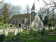
Woodmansterne is a village in Reigate and Banstead
borough of the county of Surrey
, England
. Woodmansterne village is located on the B278, which starts at Morden
and winds through Carshalton
past Oaks Park
and into the village. The road continues down to Chipstead Bottom. The railway station on the London to Tattenham Corner Line
called "Woodmansterne
" is actually located on Chipstead Valley Road Coulsdon
just inside the border of the London Borough of Croydon
.
 The village lay within the Anglo-Saxon
administrative division of Wallington
hundred
.
Woodmansterne appears in Domesday Book
of 1086 as Odemerestor, derived from Old English "Ode" = (W)ode = Wood, "mere" = pond, and "tor" = high ground. It was held by Richard de Tonebrige. Its Domesday assets were: 15 hide
s; 1 church, 1 mill
worth 20s, 5 plough
s, 4 acres (16,187.4 m²) of meadow
, wood worth 10 hogs. It rendered £8.
Reigate and Banstead
Reigate and Banstead is a local government district with borough status in east Surrey England. It covers the towns of Reigate, Banstead, Redhill and Horley....
borough of the county of Surrey
Surrey
Surrey is a county in the South East of England and is one of the Home Counties. The county borders Greater London, Kent, East Sussex, West Sussex, Hampshire and Berkshire. The historic county town is Guildford. Surrey County Council sits at Kingston upon Thames, although this has been part of...
, England
England
England is a country that is part of the United Kingdom. It shares land borders with Scotland to the north and Wales to the west; the Irish Sea is to the north west, the Celtic Sea to the south west, with the North Sea to the east and the English Channel to the south separating it from continental...
. Woodmansterne village is located on the B278, which starts at Morden
Morden
Morden is a district in the London Borough of Merton. It is located approximately South-southwest of central London between Merton Park , Mitcham , Sutton and Worcester Park .- Origin of name :...
and winds through Carshalton
Carshalton
Carshalton is a suburban area of the London Borough of Sutton, England. It is located 10 miles south-southwest of Charing Cross, situated in the valley of the River Wandle, one of the sources of which is Carshalton Ponds in the centre of the village. The combined population of the five wards...
past Oaks Park
Oaks Park, Carshalton
The Oaks Park is a public park in Carshalton in the London Borough of Sutton. It is bounded on the south by Croydon Lane , and on the east by Woodmansterne Road; smaller roads lie to west and north.-History:...
and into the village. The road continues down to Chipstead Bottom. The railway station on the London to Tattenham Corner Line
Tattenham Corner Line
The Tattenham Corner Line is a railway line in Southern England. It was opened in two parts: from Purley to Tadworth as the Chipstead Valley Railway in 1893, and to Tattenham Corner as the Epsom Downs Extension Railway in 1894. Both companies were then acquired by the South Eastern Railway...
called "Woodmansterne
Woodmansterne railway station
Woodmansterne railway station is in the London Borough of Croydon, Greater London, England, lying immediately east of the London/Surrey border. The station is on the Tattenham Corner line 23 km south of London Charing Cross. The station and all trains serving it are operated by Southern, and...
" is actually located on Chipstead Valley Road Coulsdon
Coulsdon
Coulsdon is a town on the southernmost boundary of the London Borough of Croydon. It is surrounded by the Metropolitan Green Belt of the Farthing Down, Coulsdon Common and Kenley Common...
just inside the border of the London Borough of Croydon
London Borough of Croydon
The London Borough of Croydon is a London borough in South London, England and is part of Outer London. It covers an area of and is the largest London borough by population. It is the southernmost borough of London. At its centre is the historic town of Croydon from which the borough takes its name...
.
Anglo-Saxons
Anglo-Saxon is a term used by historians to designate the Germanic tribes who invaded and settled the south and east of Great Britain beginning in the early 5th century AD, and the period from their creation of the English nation to the Norman conquest. The Anglo-Saxon Era denotes the period of...
administrative division of Wallington
Wallington (hundred)
Wallington was an ancient hundred in the north east of the county of Surrey, England. The majority of its area has been absorbed by the growth of London; with its name currently referring to the district of Wallington...
hundred
Hundred (division)
A hundred is a geographic division formerly used in England, Wales, Denmark, South Australia, some parts of the United States, Germany , Sweden, Finland and Norway, which historically was used to divide a larger region into smaller administrative divisions...
.
Woodmansterne appears in Domesday Book
Domesday Book
Domesday Book , now held at The National Archives, Kew, Richmond upon Thames in South West London, is the record of the great survey of much of England and parts of Wales completed in 1086...
of 1086 as Odemerestor, derived from Old English "Ode" = (W)ode = Wood, "mere" = pond, and "tor" = high ground. It was held by Richard de Tonebrige. Its Domesday assets were: 15 hide
Hide (unit)
The hide was originally an amount of land sufficient to support a household, but later in Anglo-Saxon England became a unit used in assessing land for liability to "geld", or land tax. The geld would be collected at a stated rate per hide...
s; 1 church, 1 mill
Mill (grinding)
A grinding mill is a unit operation designed to break a solid material into smaller pieces. There are many different types of grinding mills and many types of materials processed in them. Historically mills were powered by hand , working animal , wind or water...
worth 20s, 5 plough
Plough
The plough or plow is a tool used in farming for initial cultivation of soil in preparation for sowing seed or planting. It has been a basic instrument for most of recorded history, and represents one of the major advances in agriculture...
s, 4 acres (16,187.4 m²) of meadow
Meadow
A meadow is a field vegetated primarily by grass and other non-woody plants . The term is from Old English mædwe. In agriculture a meadow is grassland which is not grazed by domestic livestock but rather allowed to grow unchecked in order to make hay...
, wood worth 10 hogs. It rendered £8.