
Wisconsin Tornado Outbreak of August 2005
Encyclopedia
The August 2005 Wisconsin tornado outbreak was an outbreak of tornado
es that occurred primarily in southern Wisconsin
on August 18, 2005. Another tornado touched down in Minnesota
. A total of 27 tornadoes were confirmed that day in Wisconsin, the most tornadoes recorded in the state in a single day. This broke the previous record of 24 tornadoes set on May 8, 1988. The system generating the Stoughton tornado was also accompanied by many reports of severe winds and hail throughout the region.
Tornado
A tornado is a violent, dangerous, rotating column of air that is in contact with both the surface of the earth and a cumulonimbus cloud or, in rare cases, the base of a cumulus cloud. They are often referred to as a twister or a cyclone, although the word cyclone is used in meteorology in a wider...
es that occurred primarily in southern Wisconsin
Wisconsin
Wisconsin is a U.S. state located in the north-central United States and is part of the Midwest. It is bordered by Minnesota to the west, Iowa to the southwest, Illinois to the south, Lake Michigan to the east, Michigan to the northeast, and Lake Superior to the north. Wisconsin's capital is...
on August 18, 2005. Another tornado touched down in Minnesota
Minnesota
Minnesota is a U.S. state located in the Midwestern United States. The twelfth largest state of the U.S., it is the twenty-first most populous, with 5.3 million residents. Minnesota was carved out of the eastern half of the Minnesota Territory and admitted to the Union as the thirty-second state...
. A total of 27 tornadoes were confirmed that day in Wisconsin, the most tornadoes recorded in the state in a single day. This broke the previous record of 24 tornadoes set on May 8, 1988. The system generating the Stoughton tornado was also accompanied by many reports of severe winds and hail throughout the region.
The same system continued on to spawn severe weather in Southern OntarioSouthern OntarioSouthern Ontario is a region of the province of Ontario, Canada that lies south of the French River and Algonquin Park. Depending on the inclusion of the Parry Sound and Muskoka districts, its surface area would cover between 14 to 15% of the province. It is the southernmost region of...
, Canada, the next day.
Confirmed tornadoes
List of confirmed tornadoes - Thursday, August 18, 2005 F# Fujita scaleThe Fujita scale , or Fujita-Pearson scale, is a scale for rating tornado intensity, based primarily on the damage tornadoes inflict on human-built structures and vegetation...Location County Coord. Time (UTC) Path length Damage Minnesota MinnesotaMinnesota is a U.S. state located in the Midwestern United States. The twelfth largest state of the U.S., it is the twenty-first most populous, with 5.3 million residents. Minnesota was carved out of the eastern half of the Minnesota Territory and admitted to the Union as the thirty-second state...F0 N of Dexter Dexter, MinnesotaDexter is a city in Dexter Township, Mower County, Minnesota, United States. The population was 341 at the 2010 census.-History:The community was named for Dexter Parrity, an early settler...Mower, MN Mower County, MinnesotaAs of the census of 2000, there were 38,603 people, 15,582 households, and 10,315 families residing in the county. The population density was 54 people per square mile . There were 16,251 housing units at an average density of 23 per square mile...43.77°N 92.72°W 1750 0.1 mile (0.160934 km) Damaged a single livestock LivestockLivestock refers to one or more domesticated animals raised in an agricultural setting to produce commodities such as food, fiber and labor. The term "livestock" as used in this article does not include poultry or farmed fish; however the inclusion of these, especially poultry, within the meaning...
barn and flattened part of a corn field. Caused $6,000 in damages.Wisconsin WisconsinWisconsin is a U.S. state located in the north-central United States and is part of the Midwest. It is bordered by Minnesota to the west, Iowa to the southwest, Illinois to the south, Lake Michigan to the east, Michigan to the northeast, and Lake Superior to the north. Wisconsin's capital is...F0 W of Centerville Centerville, Trempealeau County, WisconsinCenterville is an unincorporated community located in the town of Trempealeau, in Trempealeau County, Wisconsin, United States. It is located at the intersection of Wisconsin Highway 95, Wisconsin Highway 93, and Wisconsin Highway 54 along the Great River Road.The Centerville Curling Club was...Trempealeau Trempealeau County, WisconsinTrempealeau County is a county located in the U.S. state of Wisconsin. As of 2009, the population estimate was 27,754. Its county seat is Whitehall.-History:Patches of woodland are all that remain of the brush and light forest that once covered the county...44.07°N 91.55°W 1918 0.1 mile (0.160934 km) Remained in a grove of trees and damaged them along its extremely short path. Caused $1,500 in damages. F1 W of Esofea Esofea, WisconsinEsofea, Wisconsin is an unincorporated community in the town of Jefferson in Vernon County, Wisconsin, United States located along County Road B.-History:...Vernon Vernon County, WisconsinVernon County is a county in the U.S. state of Wisconsin. As of 2009, the population estimate was 29,324. Its county seat is Viroqua.-History:...43.63°N 91.03°W 2046 1.2 miles (1.9 km) 1 Injury One mobile home was destroyed, injuring an occupant. A few outbuildings were destroyed as well. Several other buildings suffered varying degrees of damage, and many trees and power lines were snapped. Caused $150,000 in damages. F2 W of Liberty Liberty, WisconsinLiberty is the name of some places in the U.S. state of Wisconsin:*Liberty, Grant County, Wisconsin*Liberty, Manitowoc County, Wisconsin*Liberty, Outagamie County, Wisconsin*Liberty, Vernon County, Wisconsin...Vernon Vernon County, WisconsinVernon County is a county in the U.S. state of Wisconsin. As of 2009, the population estimate was 29,324. Its county seat is Viroqua.-History:...
, Richland43.52°N 90.77°W 2105 20 miles (32.2 km) 3 Injuries Considerable damage in the village of Viola, every building suffered at least minor damage. Heavy damage to most trees. Caused $3.569 million in damages. F1 Muscoda Muscoda, WisconsinMuscoda is a village in Grant and Iowa counties in the U.S. state of Wisconsin. The population was 1,453 at the 2000 census. The Grant County part of the village lies in the town of Muscoda, while the Iowa County portion lies in the town of Pulaski, and is the largest village in the county, and...
areaGrant Grant County, WisconsinGrant County is a county located in the U.S. state of Wisconsin. As of 2000, the population was 49,597. Its county seat is Lancaster. Estimates for 2008 show a population of 49,238...
, Richland43.18°N 90.45°W 2140 4 miles (6.4 km) One home, which was under construction, was completely destroyed. Damage was sustained to about 10 homes. Many trees and power lines were snapped. Path crossed the Wisconsin River Wisconsin River-External links:* * * , Wisconsin Historical Society* * * *...
as a waterspoutWaterspoutA waterspout is an intense columnar vortex that occurs over a body of water and is connected to a cumuliform cloud. In the common form, it is a non-supercell tornado over water. While it is often weaker than most of its land counterparts, stronger versions spawned by mesocyclones do occur...
. Caused $245,000 in damages.F1 Necedah Necedah, WisconsinNecedah is a village in Juneau County, Wisconsin, United States. The population was 888 at the 2000 census. The village is located within the Town of Necedah.-Attractions:The Necedah Shrine and the Necedah National Wildlife Refuge are located nearby....
areaMonroe Monroe County, WisconsinMonroe County is a county in the U.S. state of Wisconsin. As of 2000, the population was 40,899. Its county seat is Sparta.-Geography:According to the U.S...
, JuneauJuneau County, WisconsinJuneau County is a county located in the U.S. state of Wisconsin. As of the 2000 census, the population was 24,316. Its county seat is Mauston. It should not, however, be confused with the city of Juneau, Wisconsin, to which it has no connection.-Geography:...30.26°N 89.09°W 2154 0 mile (0 km) 3 homes suffered minor damage and a construction site Construction SiteConstruction Site is a television series created by The Jim Henson Company in 1999, and consists of 7 construction vehicles. The show was broadcast on ABC Kids for a while, and had a range of videos. It was originally produced for and shown on CITV starting in 1999. In 2000 it was nominated for a...
was destroyed. Significant damage to many trees.F0 E of Avoca Avoca, WisconsinAvoca is a village in Iowa County, Wisconsin, United States. The population was 608 at the 2000 census. It is part of the Madison Metropolitan Statistical Area.-Geography:Avoca is located at ....Iowa Iowa County, WisconsinIowa County is a county located in the U.S. state of Wisconsin. As of 2000, the population was 22,780. Its county seat and largest city is Dodgeville.Iowa County is part of the Madison Metropolitan Statistical Area.-Geography:According to the U.S...30.26°N 89.09°W 1737 0 mile (0 km) No damage was reported from this brief tornado. F1 NE of Clyde Clyde, WisconsinClyde is a town in Iowa County, Wisconsin, United States. The population was 322 at the 2000 census.-Geography:According to the United States Census Bureau, the town has a total area of 34.6 square miles , of which, 34.1 square miles of it is land and 0.5 square miles of it is...Iowa Iowa County, WisconsinIowa County is a county located in the U.S. state of Wisconsin. As of 2000, the population was 22,780. Its county seat and largest city is Dodgeville.Iowa County is part of the Madison Metropolitan Statistical Area.-Geography:According to the U.S...
, SaukSauk County, WisconsinSauk County is a county in the U.S. state of Wisconsin. As of 2000, the population was 55,225. Its county seat and largest city is Baraboo. Sauk County is included in the Baraboo Micropolitan Statistical Area and in the Madison Combined Statistical Area....30.26°N 89.09°W 1737 0 mile (0 km) F1 Spring Green Spring Green, WisconsinSpring Green is a village in Sauk County, Wisconsin, United States. The population was 1,444 at the 2000 census. The village is located within the Town of Spring Green.-Geography:Spring Green is located at ....Sauk Sauk County, WisconsinSauk County is a county in the U.S. state of Wisconsin. As of 2000, the population was 55,225. Its county seat and largest city is Baraboo. Sauk County is included in the Baraboo Micropolitan Statistical Area and in the Madison Combined Statistical Area....30.26°N 89.09°W 1737 0 mile (0 km) No real structural damage, however there were many fallen or uprooted trees. F1 Springville Springville, WisconsinSpringville is a town in Adams County in the U.S. state of Wisconsin. The population was 1,167 at the 2000 census.-Geography:Springville is located at ....Adams Adams County, WisconsinAdams County is a county in the U.S. state of Wisconsin. Sources differ as to whether its name is in honor of the second President of the United States, John Adams, or his son, the sixth President, John Quincy Adams. As of 2000, the population of Adams County was 18,643. Its county seat is...30.26°N 89.09°W 1737 0 mile (0 km) Several mobile homes were damaged. F2 Bluffview Bluffview, WisconsinBluffview is an unincorporated census-designated place located in the town of Sumpter in Sauk County, Wisconsin, United States. As of the 2010 census, its population was 742. Bluffview has an area of ; of this is land, and is water.-Notes:...
areaSauk Sauk County, WisconsinSauk County is a county in the U.S. state of Wisconsin. As of 2000, the population was 55,225. Its county seat and largest city is Baraboo. Sauk County is included in the Baraboo Micropolitan Statistical Area and in the Madison Combined Statistical Area....
, ColumbiaColumbia County, Wisconsin-Unincorporated communities:*Anacker*Belle Fountain*Durwards Glen*East Friesland*Harmony Grove*Ingle*Keyeser*Lake Wisconsin*Leeds*Lowville*Marcellon*North Leeds*Okee*Otsego-External links:***...30.26°N 89.09°W 1737 0 mile (0 km) Many trees down, several buildings damaged and some crops destroyed. F0 W of Merrimac Merrimac, WisconsinMerrimac is a village in Sauk County, Wisconsin, United States northwest of Madison. The population was 416 at the 2000 census. The village is located within the Town of Merrimac....Sauk Sauk County, WisconsinSauk County is a county in the U.S. state of Wisconsin. As of 2000, the population was 55,225. Its county seat and largest city is Baraboo. Sauk County is included in the Baraboo Micropolitan Statistical Area and in the Madison Combined Statistical Area....30.26°N 89.09°W 1737 0 mile (0 km) Spotted along the Wisconsin River Wisconsin River-External links:* * * , Wisconsin Historical Society* * * *...
.F1 NE of Westfield Westfield, WisconsinWestfield is a village in Marquette County, Wisconsin, United States. The population was 1,217 at the 2000 census. The village is located mostly within the Town of Westfield...Marquette Marquette County, WisconsinMarquette County is a county located in the U.S. state of Wisconsin. As of 2000, the population was 15,832. Its county seat is Montello.-Geography:...30.26°N 89.09°W 1737 0 mile (0 km) Many trees down and damage to at least one home. F0 NE of Lodi Lodi, WisconsinLodi is a city in Columbia County, Wisconsin, United States. As of the census of 2000, the population was 2,882. The city's estimated 2005 population was 2,929...Columbia Columbia County, Wisconsin-Unincorporated communities:*Anacker*Belle Fountain*Durwards Glen*East Friesland*Harmony Grove*Ingle*Keyeser*Lake Wisconsin*Leeds*Lowville*Marcellon*North Leeds*Okee*Otsego-External links:***...30.26°N 89.09°W 1737 0 mile (0 km) No damage reported from this brief tornado. F3 Stoughton Stoughton, WisconsinStoughton is a city in Dane County, Wisconsin, United States and is a neighbor of Madison. It straddles the Yahara River about 20 miles southeast of the capital, Madison. Stoughton is part of the Madison Metropolitan Statistical Area...
areaDane Dane County, WisconsinAs of the census of 2000, there were 426,526 people, 173,484 households, and 100,794 families residing in the county. The population density was 355 people per square mile . There were 180,398 housing units at an average density of 150 per square mile...
, JeffersonJefferson County, WisconsinJefferson County is a county located in the U.S. state of Wisconsin. As of 2000, the population was 74,021. Its county seat is Jefferson.-Geography:According to the U.S...30.26°N 89.09°W 1737 0 mile (0 km) 1 death - see section on this tornado. F0 Dane Dane, WisconsinDane is a village in Dane County, Wisconsin, United States. The population was 799 at the 2000 census. Located in the Town of Dane, the village is part of the Madison Metropolitan Statistical Area.-Geography:Dane is located at ....Dane Dane County, WisconsinAs of the census of 2000, there were 426,526 people, 173,484 households, and 100,794 families residing in the county. The population density was 355 people per square mile . There were 180,398 housing units at an average density of 150 per square mile...30.26°N 89.09°W 1737 0 mile (0 km) F1 S of Rockdale Rockdale, WisconsinRockdale is a village in Dane County, Wisconsin, United States. The population was 214 at the 2000 census. The village is split in half by the Koshkonong Creek...Dane Dane County, WisconsinAs of the census of 2000, there were 426,526 people, 173,484 households, and 100,794 families residing in the county. The population density was 355 people per square mile . There were 180,398 housing units at an average density of 150 per square mile...30.26°N 89.09°W 1737 0 mile (0 km) F0 W of Fort Atkinson Fort Atkinson, WisconsinFort Atkinson is a city in Jefferson County, Wisconsin, United States. It is located on the Rock River, a few miles upstream from Lake Koshkonong. In 1996, Money Magazine named Fort Atkinson "One of America's Hottest Little Boomtowns." The population was 11,621 at the 2000 census.- History :Fort...Jefferson Jefferson County, WisconsinJefferson County is a county located in the U.S. state of Wisconsin. As of 2000, the population was 74,021. Its county seat is Jefferson.-Geography:According to the U.S...30.26°N 89.09°W 1737 0 mile (0 km) First tornado of same tornado family as Stoughton tornado. Combined damage was minor. F1 W of Fort Atkinson Fort Atkinson, WisconsinFort Atkinson is a city in Jefferson County, Wisconsin, United States. It is located on the Rock River, a few miles upstream from Lake Koshkonong. In 1996, Money Magazine named Fort Atkinson "One of America's Hottest Little Boomtowns." The population was 11,621 at the 2000 census.- History :Fort...Jefferson Jefferson County, WisconsinJefferson County is a county located in the U.S. state of Wisconsin. As of 2000, the population was 74,021. Its county seat is Jefferson.-Geography:According to the U.S...30.26°N 89.09°W 1737 0 mile (0 km) Second tornado of same tornado family as Stoughton tornado. F1 SW of Fort Atkinson Fort Atkinson, WisconsinFort Atkinson is a city in Jefferson County, Wisconsin, United States. It is located on the Rock River, a few miles upstream from Lake Koshkonong. In 1996, Money Magazine named Fort Atkinson "One of America's Hottest Little Boomtowns." The population was 11,621 at the 2000 census.- History :Fort...Jefferson Jefferson County, WisconsinJefferson County is a county located in the U.S. state of Wisconsin. As of 2000, the population was 74,021. Its county seat is Jefferson.-Geography:According to the U.S...30.26°N 89.09°W 1737 0 mile (0 km) Third tornado of same tornado family as Stoughton tornado. F1 S of Fort Atkinson Fort Atkinson, WisconsinFort Atkinson is a city in Jefferson County, Wisconsin, United States. It is located on the Rock River, a few miles upstream from Lake Koshkonong. In 1996, Money Magazine named Fort Atkinson "One of America's Hottest Little Boomtowns." The population was 11,621 at the 2000 census.- History :Fort...Jefferson Jefferson County, WisconsinJefferson County is a county located in the U.S. state of Wisconsin. As of 2000, the population was 74,021. Its county seat is Jefferson.-Geography:According to the U.S...30.26°N 89.09°W 1737 0 mile (0 km) Fourth tornado of same tornado family as Stoughton tornado. F1 S of Fort Atkinson Fort Atkinson, WisconsinFort Atkinson is a city in Jefferson County, Wisconsin, United States. It is located on the Rock River, a few miles upstream from Lake Koshkonong. In 1996, Money Magazine named Fort Atkinson "One of America's Hottest Little Boomtowns." The population was 11,621 at the 2000 census.- History :Fort...Jefferson Jefferson County, WisconsinJefferson County is a county located in the U.S. state of Wisconsin. As of 2000, the population was 74,021. Its county seat is Jefferson.-Geography:According to the U.S...30.26°N 89.09°W 1737 0 mile (0 km) Fifth tornado of same tornado family as Stoughton tornado. F0 SE of Fort Atkinson Fort Atkinson, WisconsinFort Atkinson is a city in Jefferson County, Wisconsin, United States. It is located on the Rock River, a few miles upstream from Lake Koshkonong. In 1996, Money Magazine named Fort Atkinson "One of America's Hottest Little Boomtowns." The population was 11,621 at the 2000 census.- History :Fort...Jefferson Jefferson County, WisconsinJefferson County is a county located in the U.S. state of Wisconsin. As of 2000, the population was 74,021. Its county seat is Jefferson.-Geography:According to the U.S...30.26°N 89.09°W 1737 0 mile (0 km)) Sixth and final tornado of same tornado family as Stoughton tornado.
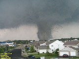
Stoughton area tornado
By far the most significant tornado of the day developed at 6:15 p.m. 2.0 miles (3.2 km) north of Oregon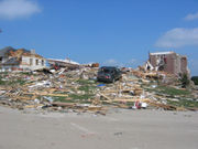 Oregon, WisconsinOregon is a village in Dane County, Wisconsin, United States. The current population of Oregon is 9498. It is part of the Madison Metropolitan Statistical Area and is a suburb of Madison. The village is located mostly within the Town of Oregon....
near FitchburgFitchburg, WisconsinFitchburg is a city in Dane County, Wisconsin, United States. The population was 25,260 at the 2010 census. Fitchburg is a suburb of Madison and is part of the Madison Metropolitan Statistical Area.-History:...
, or approximately 5 miles (8 km) south of MadisonMadison, WisconsinMadison is the capital of the U.S. state of Wisconsin and the county seat of Dane County. It is also home to the University of Wisconsin–Madison....
proper. This large, intense tornado would track for 20.0 (32.2 km) miles into Jefferson CountyJefferson County, WisconsinJefferson County is a county located in the U.S. state of Wisconsin. As of 2000, the population was 74,021. Its county seat is Jefferson.-Geography:According to the U.S...
from Dane CountyDane County, WisconsinAs of the census of 2000, there were 426,526 people, 173,484 households, and 100,794 families residing in the county. The population density was 355 people per square mile . There were 180,398 housing units at an average density of 150 per square mile...
. The unusually long-lived tornado traveled mostly east-southeasterly until just east of Stoughton where it began moving almost due easterly.
It passed through rural subdivisions and farms north of StoughtonStoughton, WisconsinStoughton is a city in Dane County, Wisconsin, United States and is a neighbor of Madison. It straddles the Yahara River about 20 miles southeast of the capital, Madison. Stoughton is part of the Madison Metropolitan Statistical Area...
at around maximum intensity and width of one-half mile (0.8 km), destroying or very heavily damaging 89 houses, heavily damaging 67 houses, with lighter damage to 84 more. Damages from the tornado totaled to $36.89 million. One person was killed and 23 were injured, three seriously. Debris from the Stoughton area was found as far away as Waukesha and Milwaukee counties (two and three counties to the east). This tornado was rated a high-end F3 on the Fujita scale (an F4 rating was considered for it) with 205 mph winds, 1 mph away from the F4 threshold. Federal disaster assistance was requested but the Federal Emergency Management AgencyFederal Emergency Management AgencyThe Federal Emergency Management Agency is an agency of the United States Department of Homeland Security, initially created by Presidential Reorganization Plan No. 1 of 1978 and implemented by two Executive Orders...
(FEMA) denied a federal disaster area declaration.
Early estimates of the path length and width appeared to point to the tornado rating F5 in the estimates of some experts. Inspection of the damage and determination that the Jefferson County tornado was separate from the Stoughton tornado as well as downward adjustment of path width led to the F4 and later high end F3 ratings. If the tornado did indeed rate F5, it would have been one of a half-dozen or fewer to occur in Wisconsin during the last 120 years.
Initial reports of portions of the path of tornado expanding to over one and a half miles in diameter over farm and swamp land west of US Highway 51 and possibly a second time when the circulation of the tornado may have been partially over Lake Kegonsa making it difficult or impossible to measure the path width at this point. Also seen was a possible touchdown of a smaller, clockwise-rotating tornado on a shorter, parallel path about 5 km/~3 mi north in the town of Dunn initially visible as a funnel cloud from the south end of McFarland. Observers estimated the tornado on the ground to have been of F0 (40-74 mph) or F- (sub-39 mph) intensity, leading to minimal damage which was hard to distinguish from effects of straight-line winds therefore the tornado touchdown never confirmed officially.
The damage pattern in the built-up areas of the tornado path and effects on crops and other plants and soil strongly suggest the existence of several suction vortices within the main tornado funnel and/or evolution into a multi-vortex tornado and back before lifting off the ground.
The tornado frequently changed in size and form and eventually became somewhat rain-wrapped after being highly visible; and finally lifted 2.2 miles (3.5 km) north of BusseyvilleBusseyville, WisconsinBusseyville, Wisconsin is an unincorporated community in the town of Sumner in Jefferson County. It is located on Wisconsin Highway 106 near Luna Road, about ten miles west of Fort Atkinson. The Sumner town hall is located there as well as Busseyville Community Church.-Notable people:The...
at 7:08 p.m. after traveling 20.0 miles (32.2 km) in an exceptional 53 minutes of continuous track. Numerous other tornadoes occurred during and after this tornado (seven as part of the tornado familyTornado familyA tornado family is a series of tornadoes spawned by the same supercell. These families form a line of successive or parallel tornado paths and can cover a short span or a vast distance. Tornado families are sometimes mistaken as a single continuous tornado, especially prior to the 1970s...
associated with the Stoughton supercellSupercellA supercell is a thunderstorm that is characterized by the presence of a mesocyclone: a deep, continuously-rotating updraft. For this reason, these storms are sometimes referred to as rotating thunderstorms...
, with the last tornado lifting at 7:53 p.m.. Ft. AtkinsonFort Atkinson, WisconsinFort Atkinson is a city in Jefferson County, Wisconsin, United States. It is located on the Rock River, a few miles upstream from Lake Koshkonong. In 1996, Money Magazine named Fort Atkinson "One of America's Hottest Little Boomtowns." The population was 11,621 at the 2000 census.- History :Fort...
was hit three times.
The parent thunderstorm dropped roof shingles and other objects from the Stoughton area on the NWS office in Sullivan, Wis. and parts of Waukesha and Milwaukee counties, 50 and more miles / 80 km away.
One death was attributed to this tornado. Loss of life was likely minimized due to the efforts of the NWS, local spotters, and Dane County emergency managers. Tornado warnings were put out well in advance of the developing tornado, and TVS (Tornadic Vortex Signatures which NWS WSR88D doppler radar detects) were seen in the Oregon area in advance of the tornado's approach.
Spotters maneuvered to the area of the TVS, and once confirmed, sirens were sounded.
Some confusion was caused due to an F0 Tornado occurring in a similar time frame in Columbia County near Lodi, some mistakenly felt the danger had either passed, or was not threatening them.
The Stoughton tornado struck on the day after a devastating fire at one of the city's largest churches (cause unrelated to severe weather) and was the climax of a two-day spate of severe weather in Southern Wisconsin; the previous day several superbolts of lightning were reported as having done extensive damage at various sites in Madison and other Dane County communities including one incident in which a tree many feet in diameter literally exploded when hit by a bolt apparently from a storm 7–10 miles away and with the sun shining at the location at the time.
Following day
On the afternoon of August 19, 2005, the same low pressure system spawned tornadoes damaging homes in Southern Ontario, Canada. The storms morphed into heavy rain cells when reaching TorontoTorontoToronto is the provincial capital of Ontario and the largest city in Canada. It is located in Southern Ontario on the northwestern shore of Lake Ontario. A relatively modern city, Toronto's history dates back to the late-18th century, when its land was first purchased by the British monarchy from...
. The Insurance Bureau of Canada has estimated that insured losses where the highest in the province's history, exceeding $500 million canadian dollarCanadian dollarThe Canadian dollar is the currency of Canada. As of 2007, the Canadian dollar is the 7th most traded currency in the world. It is abbreviated with the dollar sign $, or C$ to distinguish it from other dollar-denominated currencies...
s, two and a half times Ontario's losses during 1998 ice stormNorth American ice storm of 1998The North American ice storm of 1998 was a massive combination of five smaller successive ice storms which combined to strike a relatively narrow swath of land from eastern Ontario to southern Quebec to Nova Scotia in Canada, and bordering areas from northern New York to central Maine in the...
and the second largest loss event in Canadian history.
External links
- Stoughton Tornado Website (Jonathon G. Lampe)
- National Weather Service Milwaukee report
- NWS La Crosse report
- Photos from spotter organization MidWest SSTRC. (Dale Bernstein-President, and Dan H.)
- Video about The Tornado and Church Fire from Stoughton's Public, educational, and government accessPublic, educational, and government accessPublic, educational, and government access television, refers to three different cable television specialty channels...
cable TV channel