

Mower County, Minnesota
Encyclopedia
Census
A census is the procedure of systematically acquiring and recording information about the members of a given population. It is a regularly occurring and official count of a particular population. The term is used mostly in connection with national population and housing censuses; other common...
of 2000, there were 38,603 people, 15,582 households, and 10,315 families residing in the county. The population density
Population density
Population density is a measurement of population per unit area or unit volume. It is frequently applied to living organisms, and particularly to humans...
was 54 people per square mile (21/km²). There were 16,251 housing units at an average density of 23 per square mile (9/km²). The racial makeup of the county was 94.7% White
Race (United States Census)
Race and ethnicity in the United States Census, as defined by the Federal Office of Management and Budget and the United States Census Bureau, are self-identification data items in which residents choose the race or races with which they most closely identify, and indicate whether or not they are...
, 0.6% Black
Race (United States Census)
Race and ethnicity in the United States Census, as defined by the Federal Office of Management and Budget and the United States Census Bureau, are self-identification data items in which residents choose the race or races with which they most closely identify, and indicate whether or not they are...
or African American
Race (United States Census)
Race and ethnicity in the United States Census, as defined by the Federal Office of Management and Budget and the United States Census Bureau, are self-identification data items in which residents choose the race or races with which they most closely identify, and indicate whether or not they are...
, 0.2% Native American
Race (United States Census)
Race and ethnicity in the United States Census, as defined by the Federal Office of Management and Budget and the United States Census Bureau, are self-identification data items in which residents choose the race or races with which they most closely identify, and indicate whether or not they are...
, 1.5% Asian
Race (United States Census)
Race and ethnicity in the United States Census, as defined by the Federal Office of Management and Budget and the United States Census Bureau, are self-identification data items in which residents choose the race or races with which they most closely identify, and indicate whether or not they are...
, <0.1% Pacific Islander
Race (United States Census)
Race and ethnicity in the United States Census, as defined by the Federal Office of Management and Budget and the United States Census Bureau, are self-identification data items in which residents choose the race or races with which they most closely identify, and indicate whether or not they are...
, 2.2% from other races
Race (United States Census)
Race and ethnicity in the United States Census, as defined by the Federal Office of Management and Budget and the United States Census Bureau, are self-identification data items in which residents choose the race or races with which they most closely identify, and indicate whether or not they are...
, and 0.9% from two or more races. 4.3% of the population were Hispanic
Race (United States Census)
Race and ethnicity in the United States Census, as defined by the Federal Office of Management and Budget and the United States Census Bureau, are self-identification data items in which residents choose the race or races with which they most closely identify, and indicate whether or not they are...
or Latino
Race (United States Census)
Race and ethnicity in the United States Census, as defined by the Federal Office of Management and Budget and the United States Census Bureau, are self-identification data items in which residents choose the race or races with which they most closely identify, and indicate whether or not they are...
of any race. 35.9% were of German, 24.4% Norwegian and 7.0% Irish
Irish people
The Irish people are an ethnic group who originate in Ireland, an island in northwestern Europe. Ireland has been populated for around 9,000 years , with the Irish people's earliest ancestors recorded having legends of being descended from groups such as the Nemedians, Fomorians, Fir Bolg, Tuatha...
ancestry according to Census 2000.
There were 15,582 households out of which 29.70% had children under the age of 18 living with them, 54.70% were married couples
Marriage
Marriage is a social union or legal contract between people that creates kinship. It is an institution in which interpersonal relationships, usually intimate and sexual, are acknowledged in a variety of ways, depending on the culture or subculture in which it is found...
living together, 8.00% had a female householder with no husband present, and 33.80% were non-families. 29.10% of all households were made up of individuals and 14.80% had someone living alone who was 65 years of age or older. The average household size was 2.42 and the average family size was 2.98.
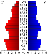
In the county the population was spread out with 25.1% under the age of 18, 8.2% from 18 to 24, 25.7% from 25 to 44, 21.4% from 45 to 64, and 19.6% who were 65 years of age or older. The median age was 39 years. For every 100 females there were 97.00 males. For every 100 females age 18 and over, there were 93.60 males.
The median income for a household in the county was $36,654, and the median income for a family was $45,154. Males had a median income of $31,743 versus $23,317 for females. The per capita income
Per capita income
Per capita income or income per person is a measure of mean income within an economic aggregate, such as a country or city. It is calculated by taking a measure of all sources of income in the aggregate and dividing it by the total population...
for the county was $19,795. About 6.3% of families and 9.2% of the population were below the poverty line, including 11.3% of those under age 18 and 5.6% of those age 65 or over.
Cities
AdamsAdams, Minnesota
Adams is a city in Adams Township, Mower County, Minnesota, United States. The population was 787 at the 2010 census.-Geography:According to the United States Census Bureau, the city has a total area of , all of it land.-Demographics:...
, Austin
Austin, Minnesota
As of the census of 2000, there were 23,314 people, 9,897 households, and 6,076 families residing in the city. The population density was 2,168.2 people per square mile . There were 10,261 housing units at an average density of 954.3 per square mile...
(the county seat
County seat
A county seat is an administrative center, or seat of government, for a county or civil parish. The term is primarily used in the United States....
), Brownsdale
Brownsdale, Minnesota
Brownsdale is a city in Red Rock Township, Mower County, Minnesota, United States. The population was 676 at the 2010 census.-Geography:According to the United States Census Bureau, the city has a total area of , all of it land.-Demographics:...
, Dexter
Dexter, Minnesota
Dexter is a city in Dexter Township, Mower County, Minnesota, United States. The population was 341 at the 2010 census.-History:The community was named for Dexter Parrity, an early settler...
, Elkton
Elkton, Minnesota
Elkton is a city in Marshall Township, Mower County, Minnesota, United States. The population was 141 at the 2010 census.-Geography:According to the United States Census Bureau, the city has a total area of , all of it land.-Demographics:...
, Grand Meadow
Grand Meadow, Minnesota
As of the census of 2000, there were 945 people, 395 households, and 233 families residing in the city. The population density was 1,470.9 people per square mile . There were 407 housing units at an average density of 633.5 per square mile...
, Le Roy
Le Roy, Minnesota
Le Roy is a city in Mower County, Minnesota, United States, surrounded by Le Roy Township. The population was 929 at the 2010 census. Lake Louise State Park is just outside of the town.-Geography:...
, Lyle
Lyle, Minnesota
As of the census of 2000, there were 566 people, 211 households, and 148 families residing in the city. The population density was 733.2 people per square mile . There were 225 housing units at an average density of 291.5 per square mile . The racial makeup of the city was 99.82% White and 0.18%...
, Mapleview
Mapleview, Minnesota
Mapleview is a city in Lansing Township, Mower County, Minnesota, United States. It is situated directly to the north of Austin's Oakwood Cemetery and can more or less be considered a suburb of Austin, although it is politically independent of it. The population was 176 at the 2010 census...
, Racine
Racine, Minnesota
Racine is a city in Racine Township, Mower County, Minnesota, United States. The population was 442 at the 2010 census.-Geography:According to the United States Census Bureau, the city has a total area of , all of it land.-Demographics:...
, Rose Creek
Rose Creek, Minnesota
Rose Creek is a city in Windom Township, Mower County, Minnesota, United States. The population was 394 at the 2010 census.-Geography:According to the United States Census Bureau, the city has a total area of , all of it land.-Demographics:...
, Sargeant
Sargeant, Minnesota
Sargeant is a city in Sargeant Township, Mower County, Minnesota, United States. The population was 61 at the 2010 census.-Geography:According to the United States Census Bureau, the city has a total area of , all of it land.-Demographics:...
, Taopi
Taopi, Minnesota
Taopi is a city in Lodi Township, Mower County, Minnesota, United States. The population was 58 at the 2010 census. It is located near the source of the Wapsipinicon River.-Geography:...
, Waltham
Waltham, Minnesota
Waltham is a city in Waltham Township, Mower County, Minnesota, United States. The population was 151 at the 2010 census.-Geography:According to the United States Census Bureau, the city has a total area of , all of it land.-Demographics:...
In order of population size (2000 census): Austin
Austin, Minnesota
As of the census of 2000, there were 23,314 people, 9,897 households, and 6,076 families residing in the city. The population density was 2,168.2 people per square mile . There were 10,261 housing units at an average density of 954.3 per square mile...
(23,314), Grand Meadow
Grand Meadow, Minnesota
As of the census of 2000, there were 945 people, 395 households, and 233 families residing in the city. The population density was 1,470.9 people per square mile . There were 407 housing units at an average density of 633.5 per square mile...
(945), Le Roy
Le Roy, Minnesota
Le Roy is a city in Mower County, Minnesota, United States, surrounded by Le Roy Township. The population was 929 at the 2010 census. Lake Louise State Park is just outside of the town.-Geography:...
(925), Adams
Adams, Minnesota
Adams is a city in Adams Township, Mower County, Minnesota, United States. The population was 787 at the 2010 census.-Geography:According to the United States Census Bureau, the city has a total area of , all of it land.-Demographics:...
(800), Brownsdale
Brownsdale, Minnesota
Brownsdale is a city in Red Rock Township, Mower County, Minnesota, United States. The population was 676 at the 2010 census.-Geography:According to the United States Census Bureau, the city has a total area of , all of it land.-Demographics:...
(718), Lyle
Lyle, Minnesota
As of the census of 2000, there were 566 people, 211 households, and 148 families residing in the city. The population density was 733.2 people per square mile . There were 225 housing units at an average density of 291.5 per square mile . The racial makeup of the city was 99.82% White and 0.18%...
(566), Racine
Racine, Minnesota
Racine is a city in Racine Township, Mower County, Minnesota, United States. The population was 442 at the 2010 census.-Geography:According to the United States Census Bureau, the city has a total area of , all of it land.-Demographics:...
(355), Rose Creek
Rose Creek, Minnesota
Rose Creek is a city in Windom Township, Mower County, Minnesota, United States. The population was 394 at the 2010 census.-Geography:According to the United States Census Bureau, the city has a total area of , all of it land.-Demographics:...
(354), Dexter
Dexter, Minnesota
Dexter is a city in Dexter Township, Mower County, Minnesota, United States. The population was 341 at the 2010 census.-History:The community was named for Dexter Parrity, an early settler...
(333), Waltham
Waltham, Minnesota
Waltham is a city in Waltham Township, Mower County, Minnesota, United States. The population was 151 at the 2010 census.-Geography:According to the United States Census Bureau, the city has a total area of , all of it land.-Demographics:...
(196), Mapleview
Mapleview, Minnesota
Mapleview is a city in Lansing Township, Mower County, Minnesota, United States. It is situated directly to the north of Austin's Oakwood Cemetery and can more or less be considered a suburb of Austin, although it is politically independent of it. The population was 176 at the 2010 census...
(189), Elkton
Elkton, Minnesota
Elkton is a city in Marshall Township, Mower County, Minnesota, United States. The population was 141 at the 2010 census.-Geography:According to the United States Census Bureau, the city has a total area of , all of it land.-Demographics:...
(149), Taopi
Taopi, Minnesota
Taopi is a city in Lodi Township, Mower County, Minnesota, United States. The population was 58 at the 2010 census. It is located near the source of the Wapsipinicon River.-Geography:...
(93), Sargeant
Sargeant, Minnesota
Sargeant is a city in Sargeant Township, Mower County, Minnesota, United States. The population was 61 at the 2010 census.-Geography:According to the United States Census Bureau, the city has a total area of , all of it land.-Demographics:...
(76).
Townships
All of Mower County's land is divided into 20 townships that are 36 square miles (six miles north to southSouth
South is a noun, adjective, or adverb indicating direction or geography.South is one of the four cardinal directions or compass points. It is the opposite of north and is perpendicular to east and west.By convention, the bottom side of a map is south....
X six miles (10 km) west to east) in area
Area
Area is a quantity that expresses the extent of a two-dimensional surface or shape in the plane. Area can be understood as the amount of material with a given thickness that would be necessary to fashion a model of the shape, or the amount of paint necessary to cover the surface with a single coat...
. Mower County is five townships wide (a total of 30 miles (48.3 km) west to east) and four townships from north to south (a total of 24 miles). The arrangement of the townships within the county is shown below (Udolpho Township
Udolpho Township, Minnesota
Udolpho Township is a township in Mower County, Minnesota, United States. The population was 458 at the 2000 census. There are no recognized cities or towns and the whole township is an unincorporated area. Blooming Prairie is only about a quarter of a mile away in Steele County to the north...
is in the northwest corner and Le Roy Township
Le Roy Township, Minnesota
Le Roy Township is a township in Mower County, Minnesota, United States. The population was 396 at the 2000 census. The town in the township with the largest population is Le Roy with 925 people. The township is also home to Lake Louise State Park, the only Minnesota State Park in Mower County...
is in the southeast).
| Location of townships Township (United States) A township in the United States is a small geographic area. Townships range in size from 6 to 54 square miles , with being the norm.The term is used in three ways.... in Mower County |
||||
|---|---|---|---|---|
| 1 | 2 | 3 | 4 | 5 |
| 1 Udolpho | Waltham | Sargeant | Pleasant Valley | Racine |
| 2 Lansing | Red Rock | Dexter | Grand Meadow | Frankford |
| 3 Austin | Windom | Marshall | Clayton | Bennington |
| 4 Lyle | Nevada | Adams | Lodi | Le Roy |
Administration
Five people are elected as Mower County Commissioners, serving staggered four year terms. Commissioners work to provide services to people and communities while overseeing the cost of such services. The Mower County Board meets the first, second, and fourth Tuesday each month in the Board Room located in the Lower Level of the Mower County Courthouse. The first meeting of the month begins at 1:00 PM while the remaining begin with departmental business at 8:30 AM with general business starting around 10:00 AM.- First District- Cities: BrownsdaleBrownsdale, MinnesotaBrownsdale is a city in Red Rock Township, Mower County, Minnesota, United States. The population was 676 at the 2010 census.-Geography:According to the United States Census Bureau, the city has a total area of , all of it land.-Demographics:...
, MapleviewMapleview, MinnesotaMapleview is a city in Lansing Township, Mower County, Minnesota, United States. It is situated directly to the north of Austin's Oakwood Cemetery and can more or less be considered a suburb of Austin, although it is politically independent of it. The population was 176 at the 2010 census...
, WalthamWaltham, MinnesotaWaltham is a city in Waltham Township, Mower County, Minnesota, United States. The population was 151 at the 2010 census.-Geography:According to the United States Census Bureau, the city has a total area of , all of it land.-Demographics:...
and the 1st Ward, 1st Precinct of AustinAustin, MinnesotaAs of the census of 2000, there were 23,314 people, 9,897 households, and 6,076 families residing in the city. The population density was 2,168.2 people per square mile . There were 10,261 housing units at an average density of 954.3 per square mile...
- Townships: Lansing Township, Red Rock Township, Udolpho Township, Waltham Township
- Commissioner: Tim Gabrielson
- Townships: Lansing Township, Red Rock Township, Udolpho Township, Waltham Township
- Second District- Cities: AdamsAdams, MinnesotaAdams is a city in Adams Township, Mower County, Minnesota, United States. The population was 787 at the 2010 census.-Geography:According to the United States Census Bureau, the city has a total area of , all of it land.-Demographics:...
, DexterDexter, MinnesotaDexter is a city in Dexter Township, Mower County, Minnesota, United States. The population was 341 at the 2010 census.-History:The community was named for Dexter Parrity, an early settler...
, ElktonElkton, MinnesotaElkton is a city in Marshall Township, Mower County, Minnesota, United States. The population was 141 at the 2010 census.-Geography:According to the United States Census Bureau, the city has a total area of , all of it land.-Demographics:...
, Grand MeadowGrand Meadow, MinnesotaAs of the census of 2000, there were 945 people, 395 households, and 233 families residing in the city. The population density was 1,470.9 people per square mile . There were 407 housing units at an average density of 633.5 per square mile...
, Le RoyLe Roy, MinnesotaLe Roy is a city in Mower County, Minnesota, United States, surrounded by Le Roy Township. The population was 929 at the 2010 census. Lake Louise State Park is just outside of the town.-Geography:...
, RacineRacine, MinnesotaRacine is a city in Racine Township, Mower County, Minnesota, United States. The population was 442 at the 2010 census.-Geography:According to the United States Census Bureau, the city has a total area of , all of it land.-Demographics:...
, SargeantSargeant, MinnesotaSargeant is a city in Sargeant Township, Mower County, Minnesota, United States. The population was 61 at the 2010 census.-Geography:According to the United States Census Bureau, the city has a total area of , all of it land.-Demographics:...
, TaopiTaopi, MinnesotaTaopi is a city in Lodi Township, Mower County, Minnesota, United States. The population was 58 at the 2010 census. It is located near the source of the Wapsipinicon River.-Geography:...
- Townships: Adams Township, Bennington Township, Clayton Township, Dexter Township, Frankford Township, Grand Meadow Township, Le Roy Township, Lodi Township, Marshall Township, Pleasant Valley Township, Racine Township, Sargeant Township
- Commissioner:Raymond Tucker
- Townships: Adams Township, Bennington Township, Clayton Township, Dexter Township, Frankford Township, Grand Meadow Township, Le Roy Township, Lodi Township, Marshall Township, Pleasant Valley Township, Racine Township, Sargeant Township
- Third District- Cities: Lyle, Rose Creek and the 2nd Ward, 2nd Precinct of the City of Austin.
- Townships: Austin, Lyle, Nevada and Windom.
- Commissioner: Jerry Reinartz
- Townships: Austin, Lyle, Nevada and Windom.
- Fourth District - The 4th District includes all of the 3rd ward of the city of Austin.
- Commissioner:Tony Bennett
- Fifth District - The 5th District includes the 1st Ward, 2nd Precinct and the 2nd Ward 1st Princt of the City of Austin.
- Commissioner: Mike Ankeny