
Marquette County, Wisconsin
Encyclopedia
Marquette County is a county located in the U.S. state
of Wisconsin
. As of 2000, the population was 15,832. Its county seat
is Montello
.
, the county has a total area of 464 square miles (1,203 km²), of which 455 square miles (1,180 km²) is land and 9 square miles (23 km²) (1.92%) is water. The Mecan River, Buffalo Lake, and Puckaway Lake lie within Marquette County. The highest altitude in the county is a rocky area known as Mt. Shaw.
As of the census
of 2000, there were 15,832 people, 5,986 households, and 4,166 families residing in the county. The population density
was 35 people per square mile (13/km²). There were 8,664 housing units at an average density of 19 per square mile (7/km²). The racial makeup of the county was 93.66% White
, 3.44% Black
or African American
, 1.04% Native American
, 0.27% Asian
, 0.10% Pacific Islander
, 0.38% from other races
, and 1.11% from two or more races. 2.66% of the population were Hispanic
or Latino
of any race. 45.7% were of German, 8.2% Irish
, 6.9% Polish, 6.1% English
, 5.6% Norwegian and 5.1% American
ancestry according to Census 2000. 94.8% spoke English
, 2.8% Spanish
and 1.1% German
as their first language.
There were 5,986 households out of which 26.90% had children under the age of 18 living with them, 58.70% were married couples
living together, 6.70% had a female householder with no husband present, and 30.40% were non-families. 25.40% of all households were made up of individuals and 12.30% had someone living alone who was 65 years of age or older. The average household size was 2.41 and the average family size was 2.86.
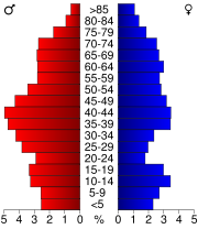
In the county, the population was spread out with 21.10% under the age of 18, 6.70% from 18 to 24, 28.90% from 25 to 44, 25.00% from 45 to 64, and 18.30% who were 65 years of age or older. The median age was 41 years. For every 100 females there were 118.90 males. For every 100 females age 18 and over, there were 123.70 males.
U.S. state
A U.S. state is any one of the 50 federated states of the United States of America that share sovereignty with the federal government. Because of this shared sovereignty, an American is a citizen both of the federal entity and of his or her state of domicile. Four states use the official title of...
of Wisconsin
Wisconsin
Wisconsin is a U.S. state located in the north-central United States and is part of the Midwest. It is bordered by Minnesota to the west, Iowa to the southwest, Illinois to the south, Lake Michigan to the east, Michigan to the northeast, and Lake Superior to the north. Wisconsin's capital is...
. As of 2000, the population was 15,832. Its county seat
County seat
A county seat is an administrative center, or seat of government, for a county or civil parish. The term is primarily used in the United States....
is Montello
Montello, Wisconsin
Montello is a city in and the county seat of Marquette County, Wisconsin, United States. The population was 1,397 at the 2000 census. The Fox River flows through the city...
.
Geography
According to the U.S. Census BureauUnited States Census Bureau
The United States Census Bureau is the government agency that is responsible for the United States Census. It also gathers other national demographic and economic data...
, the county has a total area of 464 square miles (1,203 km²), of which 455 square miles (1,180 km²) is land and 9 square miles (23 km²) (1.92%) is water. The Mecan River, Buffalo Lake, and Puckaway Lake lie within Marquette County. The highest altitude in the county is a rocky area known as Mt. Shaw.
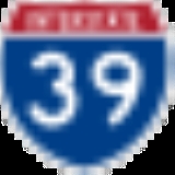
Major highways

 U.S. Highway 51


Adjacent counties
- Waushara County - north
- Green Lake CountyGreen Lake County, WisconsinGreen Lake County is a county located in the U.S. state of Wisconsin. As of 2000, the population was 19,105. Its county seat is Green Lake. The center of population of Wisconsin is located in Green Lake County in the city of Markesan.-Geography:...
- east - Columbia CountyColumbia County, Wisconsin-Unincorporated communities:*Anacker*Belle Fountain*Durwards Glen*East Friesland*Harmony Grove*Ingle*Keyeser*Lake Wisconsin*Leeds*Lowville*Marcellon*North Leeds*Okee*Otsego-External links:***...
- south - Adams CountyAdams County, WisconsinAdams County is a county in the U.S. state of Wisconsin. Sources differ as to whether its name is in honor of the second President of the United States, John Adams, or his son, the sixth President, John Quincy Adams. As of 2000, the population of Adams County was 18,643. Its county seat is...
- west
Demographics
As of the census
Census
A census is the procedure of systematically acquiring and recording information about the members of a given population. It is a regularly occurring and official count of a particular population. The term is used mostly in connection with national population and housing censuses; other common...
of 2000, there were 15,832 people, 5,986 households, and 4,166 families residing in the county. The population density
Population density
Population density is a measurement of population per unit area or unit volume. It is frequently applied to living organisms, and particularly to humans...
was 35 people per square mile (13/km²). There were 8,664 housing units at an average density of 19 per square mile (7/km²). The racial makeup of the county was 93.66% White
Race (United States Census)
Race and ethnicity in the United States Census, as defined by the Federal Office of Management and Budget and the United States Census Bureau, are self-identification data items in which residents choose the race or races with which they most closely identify, and indicate whether or not they are...
, 3.44% Black
Race (United States Census)
Race and ethnicity in the United States Census, as defined by the Federal Office of Management and Budget and the United States Census Bureau, are self-identification data items in which residents choose the race or races with which they most closely identify, and indicate whether or not they are...
or African American
Race (United States Census)
Race and ethnicity in the United States Census, as defined by the Federal Office of Management and Budget and the United States Census Bureau, are self-identification data items in which residents choose the race or races with which they most closely identify, and indicate whether or not they are...
, 1.04% Native American
Race (United States Census)
Race and ethnicity in the United States Census, as defined by the Federal Office of Management and Budget and the United States Census Bureau, are self-identification data items in which residents choose the race or races with which they most closely identify, and indicate whether or not they are...
, 0.27% Asian
Race (United States Census)
Race and ethnicity in the United States Census, as defined by the Federal Office of Management and Budget and the United States Census Bureau, are self-identification data items in which residents choose the race or races with which they most closely identify, and indicate whether or not they are...
, 0.10% Pacific Islander
Race (United States Census)
Race and ethnicity in the United States Census, as defined by the Federal Office of Management and Budget and the United States Census Bureau, are self-identification data items in which residents choose the race or races with which they most closely identify, and indicate whether or not they are...
, 0.38% from other races
Race (United States Census)
Race and ethnicity in the United States Census, as defined by the Federal Office of Management and Budget and the United States Census Bureau, are self-identification data items in which residents choose the race or races with which they most closely identify, and indicate whether or not they are...
, and 1.11% from two or more races. 2.66% of the population were Hispanic
Race (United States Census)
Race and ethnicity in the United States Census, as defined by the Federal Office of Management and Budget and the United States Census Bureau, are self-identification data items in which residents choose the race or races with which they most closely identify, and indicate whether or not they are...
or Latino
Race (United States Census)
Race and ethnicity in the United States Census, as defined by the Federal Office of Management and Budget and the United States Census Bureau, are self-identification data items in which residents choose the race or races with which they most closely identify, and indicate whether or not they are...
of any race. 45.7% were of German, 8.2% Irish
Irish people
The Irish people are an ethnic group who originate in Ireland, an island in northwestern Europe. Ireland has been populated for around 9,000 years , with the Irish people's earliest ancestors recorded having legends of being descended from groups such as the Nemedians, Fomorians, Fir Bolg, Tuatha...
, 6.9% Polish, 6.1% English
English people
The English are a nation and ethnic group native to England, who speak English. The English identity is of early mediaeval origin, when they were known in Old English as the Anglecynn. England is now a country of the United Kingdom, and the majority of English people in England are British Citizens...
, 5.6% Norwegian and 5.1% American
United States
The United States of America is a federal constitutional republic comprising fifty states and a federal district...
ancestry according to Census 2000. 94.8% spoke English
English language
English is a West Germanic language that arose in the Anglo-Saxon kingdoms of England and spread into what was to become south-east Scotland under the influence of the Anglian medieval kingdom of Northumbria...
, 2.8% Spanish
Spanish language
Spanish , also known as Castilian , is a Romance language in the Ibero-Romance group that evolved from several languages and dialects in central-northern Iberia around the 9th century and gradually spread with the expansion of the Kingdom of Castile into central and southern Iberia during the...
and 1.1% German
German language
German is a West Germanic language, related to and classified alongside English and Dutch. With an estimated 90 – 98 million native speakers, German is one of the world's major languages and is the most widely-spoken first language in the European Union....
as their first language.
There were 5,986 households out of which 26.90% had children under the age of 18 living with them, 58.70% were married couples
Marriage
Marriage is a social union or legal contract between people that creates kinship. It is an institution in which interpersonal relationships, usually intimate and sexual, are acknowledged in a variety of ways, depending on the culture or subculture in which it is found...
living together, 6.70% had a female householder with no husband present, and 30.40% were non-families. 25.40% of all households were made up of individuals and 12.30% had someone living alone who was 65 years of age or older. The average household size was 2.41 and the average family size was 2.86.
In the county, the population was spread out with 21.10% under the age of 18, 6.70% from 18 to 24, 28.90% from 25 to 44, 25.00% from 45 to 64, and 18.30% who were 65 years of age or older. The median age was 41 years. For every 100 females there were 118.90 males. For every 100 females age 18 and over, there were 123.70 males.
Cities, villages, and towns
- BuffaloBuffalo, Marquette County, WisconsinBuffalo is a town in Marquette County, Wisconsin, in the United States. As of the 2000 census, the town population was 1,085.-Geography:According to the United States Census Bureau, the town has a total area of 49.3 square miles , of which, 48.5 square miles of it is land and...
- Crystal LakeCrystal Lake, Marquette County, WisconsinCrystal Lake is a town in Marquette County, Wisconsin, United States. The population was 513 at the 2000 census. The unincorporated community of Budsin is located in the town.-Geography:...
- DouglasDouglas, WisconsinDouglas is a town in Marquette County, Wisconsin, United States. The population was 768 at the 2000 census. The unincorporated community of Briggsville is located within the town.-Geography:...
- EndeavorEndeavor, WisconsinEndeavor is a village in Marquette County, Wisconsin, United States. The population was 440 at the 2000 census.-Geography:Endeavor is located at ....
- HarrisHarris, WisconsinHarris is a town located in Marquette County, Wisconsin. According to the 2000 census, the town had a total population of 729. The unincorporated community of Harrisville is located in the town.- Geography :...
- MecanMecan, WisconsinMecan is a town in Marquette County, Wisconsin, United States. The population was 726 at the 2000 census.-Geography:According to the United States Census Bureau, the town has a total area of 27.5 square miles , of which, 27.5 square miles of it is land and 0.1 square miles of it ...
- Montello (town)Montello (town), WisconsinMontello is a town in Marquette County, Wisconsin, United States. The population was 1,043 at the 2000 census. The City of Montello is located within the town...
- MontelloMontello, WisconsinMontello is a city in and the county seat of Marquette County, Wisconsin, United States. The population was 1,397 at the 2000 census. The Fox River flows through the city...
- MoundvilleMoundville, WisconsinMoundville is a town in Marquette County, Wisconsin, United States. The population was 574 at the 2000 census.-Geography:According to the United States Census Bureau, the town has a total area of 23.2 square miles , of which, 22.9 square miles of it is land and 0.3 square miles of...
- Neshkoro (town)Neshkoro (town), WisconsinNeshkoro is a town in Marquette County, Wisconsin, United States. The population was 595 at the 2000 census. The Village of Neshkoro is located within the town.-Geography:...
- NeshkoroNeshkoro, WisconsinNeshkoro is a village in Marquette County, Wisconsin, United States. The population was 453 at the 2000 census. The village is located within the Town of Neshkoro.-Geography:Neshkoro is located at ....
- NewtonNewton, Marquette County, WisconsinNewton is a town in Marquette County, Wisconsin, United States. The population was 550 at the 2000 census.-Geography:According to the United States Census Bureau, the town has a total area of 35.6 square miles , of which, 35.5 square miles of it is land and 0.1 square miles of it ...
- Oxford (town)Oxford (town), WisconsinOxford is a town in Marquette County, Wisconsin, United States. The population was 859 at the 2000 census. The Village of Oxford is located within the town.-Geography:...
- OxfordOxford, WisconsinOxford is a village in Marquette County, Wisconsin, United States. The population was 536 at the 2000 census. The village is located within the Town of Oxford.-Geography:Oxford is located at ....
- PackwaukeePackwaukee, WisconsinPackwaukee is a town in Marquette County, Wisconsin, United States. The population was 2,574 at the 2000 census. The unincorporated communities of Buffalo Shore Estates and Packwaukee are located in the town.-Geography:...
- ShieldsShields, Marquette County, WisconsinShields is a town in Marquette County, Wisconsin, United States. The population was 456 at the 2000 census. The unincorporated community of Germania is located in the town.-Geography:...
- SpringfieldSpringfield, Marquette County, WisconsinSpringfield is a town in Marquette County, Wisconsin, United States. The population was 628 at the 2000 census.-Geography:According to the United States Census Bureau, the town has a total area of 34.9 square miles , of which, 34.6 square miles of it is land and 0.3 square miles of...
- Westfield (town)Westfield, Marquette County, WisconsinWestfield is a town located in Marquette County, Wisconsin. As of the 2000 census, the town had a total population of 689. The Village of Westfield is located mostly within the town...
- WestfieldWestfield, WisconsinWestfield is a village in Marquette County, Wisconsin, United States. The population was 1,217 at the 2000 census. The village is located mostly within the Town of Westfield...
Unincorporated communities
- BriggsvilleBriggsville, WisconsinBriggsville, Wisconsin is an unincorporated community in the southwest corner of Marquette County, Wisconsin, in the town of Douglas. It is located on Wisconsin Highway 23. It uses ZIP code 53920. It is located on the eastern side of Lake Mason....
- BudsinBudsin, WisconsinBudsin is an unincorporated community in the Town of Crystal Lake in Marquette County, Wisconsin, centered around the junction of County Highway E and Wisconsin Highway 22....
- Buffalo Shore EstatesBuffalo Shore Estates, WisconsinBuffalo Shore Estates is an unincorporated community located in the town of Packwaukee, Marquette County, Wisconsin, United States....
- GermaniaGermania, Marquette County, WisconsinGermania is an unincorporated community located in the town of Shields, Marquette County, Wisconsin, United States....
- Glen OakGlen Oak, WisconsinGlen Oak is an unincorporated community located in the town of Montello, Marquette County, Wisconsin, United States....
- HarrisvilleHarrisville, WisconsinHarrisville is an unincorporated community located in the town of Harris, Marquette County, Wisconsin, United States....
- LawrenceLawrence, Marquette County, WisconsinLawrence is an unincorporated community located in the town of Westfield, Marquette County, Wisconsin, United States....
- Packwaukee
See also
- National Register of Historic Places listings in Marquette County, Wisconsin