

Juneau County, Wisconsin
Encyclopedia
Juneau County is a county
located in the U.S. state
of Wisconsin
. As of the 2000 census
, the population was 24,316. Its county seat
is Mauston
. It should not, however, be confused with the city of Juneau, Wisconsin, to which it has no connection.
, the county has a total area of 804 square miles (2,082.4 km²), of which 768 square miles (1,989.1 km²) is land and 37 square miles (95.8 km²) (4.54%) is water.
As of the census
of 2000, there were 24,316 people, 9,696 households, and 6,699 families residing in the county. The population density
was 32 people per square mile (12/km²). There were 12,370 housing units at an average density of 16 per square mile (6/km²). The racial makeup of the county was 96.61% White
, 0.33% Black
or African American
, 1.30% Native American
, 0.44% Asian
, 0.02% Pacific Islander
, 0.57% from other races
, and 0.74% from two or more races. 1.43% of the population were Hispanic
or Latino
of any race. 41.2% were of German, 9.9% Irish
, 8.8% Norwegian, 6.5% Polish and 5.8% English
ancestry according to Census 2000.
There were 9,696 households out of which 30.4% had children under the age of 18 living with them, 55.5% were married couples
living together, 8.8% had a female householder with no husband present, and 30.9% were non-families. 26.0% of all households were made up of individuals and 12.30% had someone living alone who was 65 years of age or older. The average household size was 2.47 and the average family size was 2.96.
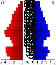
In the county, the population was spread out with 25.4% under the age of 18, 6.9% from 18 to 24, 26.6% from 25 to 44, 24.3% from 45 to 64, and 16.8% who were 65 years of age or older. The median age was 39 years. For every 100 females there were 100.1 males. For every 100 females age 18 and over, there were 97.4 males.
County (United States)
In the United States, a county is a geographic subdivision of a state , usually assigned some governmental authority. The term "county" is used in 48 of the 50 states; Louisiana is divided into parishes and Alaska into boroughs. Parishes and boroughs are called "county-equivalents" by the U.S...
located in the U.S. state
U.S. state
A U.S. state is any one of the 50 federated states of the United States of America that share sovereignty with the federal government. Because of this shared sovereignty, an American is a citizen both of the federal entity and of his or her state of domicile. Four states use the official title of...
of Wisconsin
Wisconsin
Wisconsin is a U.S. state located in the north-central United States and is part of the Midwest. It is bordered by Minnesota to the west, Iowa to the southwest, Illinois to the south, Lake Michigan to the east, Michigan to the northeast, and Lake Superior to the north. Wisconsin's capital is...
. As of the 2000 census
United States Census, 2000
The Twenty-second United States Census, known as Census 2000 and conducted by the Census Bureau, determined the resident population of the United States on April 1, 2000, to be 281,421,906, an increase of 13.2% over the 248,709,873 persons enumerated during the 1990 Census...
, the population was 24,316. Its county seat
County seat
A county seat is an administrative center, or seat of government, for a county or civil parish. The term is primarily used in the United States....
is Mauston
Mauston, Wisconsin
Mauston is a city in and the county seat of Juneau County, Wisconsin, United States. The population is 4,411 according to the 2010 census.-History:...
. It should not, however, be confused with the city of Juneau, Wisconsin, to which it has no connection.
Geography
According to the U.S. Census BureauUnited States Census Bureau
The United States Census Bureau is the government agency that is responsible for the United States Census. It also gathers other national demographic and economic data...
, the county has a total area of 804 square miles (2,082.4 km²), of which 768 square miles (1,989.1 km²) is land and 37 square miles (95.8 km²) (4.54%) is water.
Major highways


 U.S. Highway 12


Adjacent counties
- Wood County - north
- Adams CountyAdams County, WisconsinAdams County is a county in the U.S. state of Wisconsin. Sources differ as to whether its name is in honor of the second President of the United States, John Adams, or his son, the sixth President, John Quincy Adams. As of 2000, the population of Adams County was 18,643. Its county seat is...
- east - Columbia CountyColumbia County, Wisconsin-Unincorporated communities:*Anacker*Belle Fountain*Durwards Glen*East Friesland*Harmony Grove*Ingle*Keyeser*Lake Wisconsin*Leeds*Lowville*Marcellon*North Leeds*Okee*Otsego-External links:***...
- southeast - Sauk CountySauk County, WisconsinSauk County is a county in the U.S. state of Wisconsin. As of 2000, the population was 55,225. Its county seat and largest city is Baraboo. Sauk County is included in the Baraboo Micropolitan Statistical Area and in the Madison Combined Statistical Area....
- south - Vernon CountyVernon County, WisconsinVernon County is a county in the U.S. state of Wisconsin. As of 2009, the population estimate was 29,324. Its county seat is Viroqua.-History:...
- southwest - Monroe CountyMonroe County, WisconsinMonroe County is a county in the U.S. state of Wisconsin. As of 2000, the population was 40,899. Its county seat is Sparta.-Geography:According to the U.S...
- west - Jackson CountyJackson County, WisconsinJackson County is a county located in the U.S. state of Wisconsin. As of 2009, the population estimate was 19,886. Its county seat is Black River Falls. Jackson County was formed from Crawford County in 1853.-Geography:According to the U.S...
- northwest
Demographics
As of the census
Census
A census is the procedure of systematically acquiring and recording information about the members of a given population. It is a regularly occurring and official count of a particular population. The term is used mostly in connection with national population and housing censuses; other common...
of 2000, there were 24,316 people, 9,696 households, and 6,699 families residing in the county. The population density
Population density
Population density is a measurement of population per unit area or unit volume. It is frequently applied to living organisms, and particularly to humans...
was 32 people per square mile (12/km²). There were 12,370 housing units at an average density of 16 per square mile (6/km²). The racial makeup of the county was 96.61% White
Race (United States Census)
Race and ethnicity in the United States Census, as defined by the Federal Office of Management and Budget and the United States Census Bureau, are self-identification data items in which residents choose the race or races with which they most closely identify, and indicate whether or not they are...
, 0.33% Black
Race (United States Census)
Race and ethnicity in the United States Census, as defined by the Federal Office of Management and Budget and the United States Census Bureau, are self-identification data items in which residents choose the race or races with which they most closely identify, and indicate whether or not they are...
or African American
Race (United States Census)
Race and ethnicity in the United States Census, as defined by the Federal Office of Management and Budget and the United States Census Bureau, are self-identification data items in which residents choose the race or races with which they most closely identify, and indicate whether or not they are...
, 1.30% Native American
Race (United States Census)
Race and ethnicity in the United States Census, as defined by the Federal Office of Management and Budget and the United States Census Bureau, are self-identification data items in which residents choose the race or races with which they most closely identify, and indicate whether or not they are...
, 0.44% Asian
Race (United States Census)
Race and ethnicity in the United States Census, as defined by the Federal Office of Management and Budget and the United States Census Bureau, are self-identification data items in which residents choose the race or races with which they most closely identify, and indicate whether or not they are...
, 0.02% Pacific Islander
Race (United States Census)
Race and ethnicity in the United States Census, as defined by the Federal Office of Management and Budget and the United States Census Bureau, are self-identification data items in which residents choose the race or races with which they most closely identify, and indicate whether or not they are...
, 0.57% from other races
Race (United States Census)
Race and ethnicity in the United States Census, as defined by the Federal Office of Management and Budget and the United States Census Bureau, are self-identification data items in which residents choose the race or races with which they most closely identify, and indicate whether or not they are...
, and 0.74% from two or more races. 1.43% of the population were Hispanic
Race (United States Census)
Race and ethnicity in the United States Census, as defined by the Federal Office of Management and Budget and the United States Census Bureau, are self-identification data items in which residents choose the race or races with which they most closely identify, and indicate whether or not they are...
or Latino
Race (United States Census)
Race and ethnicity in the United States Census, as defined by the Federal Office of Management and Budget and the United States Census Bureau, are self-identification data items in which residents choose the race or races with which they most closely identify, and indicate whether or not they are...
of any race. 41.2% were of German, 9.9% Irish
Irish people
The Irish people are an ethnic group who originate in Ireland, an island in northwestern Europe. Ireland has been populated for around 9,000 years , with the Irish people's earliest ancestors recorded having legends of being descended from groups such as the Nemedians, Fomorians, Fir Bolg, Tuatha...
, 8.8% Norwegian, 6.5% Polish and 5.8% English
English people
The English are a nation and ethnic group native to England, who speak English. The English identity is of early mediaeval origin, when they were known in Old English as the Anglecynn. England is now a country of the United Kingdom, and the majority of English people in England are British Citizens...
ancestry according to Census 2000.
There were 9,696 households out of which 30.4% had children under the age of 18 living with them, 55.5% were married couples
Marriage
Marriage is a social union or legal contract between people that creates kinship. It is an institution in which interpersonal relationships, usually intimate and sexual, are acknowledged in a variety of ways, depending on the culture or subculture in which it is found...
living together, 8.8% had a female householder with no husband present, and 30.9% were non-families. 26.0% of all households were made up of individuals and 12.30% had someone living alone who was 65 years of age or older. The average household size was 2.47 and the average family size was 2.96.
In the county, the population was spread out with 25.4% under the age of 18, 6.9% from 18 to 24, 26.6% from 25 to 44, 24.3% from 45 to 64, and 16.8% who were 65 years of age or older. The median age was 39 years. For every 100 females there were 100.1 males. For every 100 females age 18 and over, there were 97.4 males.
Cities, villages, and towns
- ArmeniaArmenia, WisconsinArmenia is a town in Juneau County, Wisconsin, United States. The population was 707 at the 2000 census. The unincorporated community of New Miner is located in the town.-Geography:...
- Camp DouglasCamp Douglas, WisconsinCamp Douglas is a village in Juneau County, Wisconsin, United States. The population was 592 at the 2000 census. Camp Douglas is home to Volk Field Air National Guard Base.-History:...
- ClearfieldClearfield, WisconsinClearfield is a town in Juneau County, Wisconsin, United States. The population was 737 at the 2000 census.-Geography:According to the United States Census Bureau, the town has a total area of 35.8 square miles , all of it land....
- CutlerCutler, WisconsinCutler is a town in Juneau County, Wisconsin, United States. The population was 282 at the 2000 census. The unincorporated community of Cutler is located in the town.-Geography:...
- ElroyElroy, WisconsinElroy is a city in Juneau County, Wisconsin, United States, along the Baraboo River and at the east end of the Elroy-Sparta Bike Trail. The population was 1,578 at the 2000 census.-Geography:Elroy is located at ....
- FinleyFinley, WisconsinFinley is a town in Juneau County, Wisconsin, United States. The population was 84 at the 2000 census. The unincorporated community of Finley is located in the town.-Geography:...
- FountainFountain, WisconsinFountain is a town in Juneau County, Wisconsin, United States. The population was 582 at the 2000 census.-Geography:According to the United States Census Bureau, the town has a total area of 30.8 square miles , all of it land....
- GermantownGermantown, Juneau County, WisconsinGermantown is a town in Juneau County, Wisconsin, in the United States. As of the 2000 census, the town population was 1,174.-Geography:According to the United States Census Bureau, the town has a total area of 45.0 square miles , of which, 33.2 square miles of it is land and...
- HustlerHustler, WisconsinHustler is a village in Juneau County, Wisconsin, United States. The population was 113 at the 2000 census.-Geography:Hustler is located at ....
- KildareKildare, WisconsinKildare is a town in Juneau County, Wisconsin, United States. The population was 557 at the 2000 census.It was named after the town and county of Kildare in Ireland.-Geography:...
- KingstonKingston, Juneau County, WisconsinKingston is a town in Juneau County, Wisconsin, United States. The population was 58 at the 2000 census. The unincorporated communities of Mather and Meadow Valley are located in the town.-Geography:...
- LemonweirLemonweir, WisconsinLemonweir is a town in Juneau County, Wisconsin, United States. The population was 1,763 at the 2000 census. The unincorporated community of Lemonweir is located in the town.-Geography:...
- LindinaLindina, WisconsinLindina is a town in Juneau County, Wisconsin, United States. The population was 730 at the 2000 census. The unincorporated community of Lindina is located in the town.-Geography:...
- LisbonLisbon, Juneau County, WisconsinLisbon is a town in Juneau County, Wisconsin, United States. The population was 1,020 at the 2000 census.-Geography:According to the United States Census Bureau, the town has a total area of 28.3 square miles , of which, 28.2 square miles of it is land and 0.1 square miles of it ...
- Lyndon StationLyndon Station, WisconsinLyndon Station is a village in Juneau County, Wisconsin, United States. The population was 458 at the 2000 census.-Geography:Lyndon Station is located at ....
- LyndonLyndon, Juneau County, WisconsinLyndon is a town in Juneau County, Wisconsin, United States. The population was 1,217 at the 2000 census.-Geography:According to the United States Census Bureau, the town has a total area of 29.6 square miles , of which, 28.3 square miles of it is land and 1.3 square miles of it ...
- MarionMarion, Juneau County, WisconsinMarion is a town in Juneau County, Wisconsin, United States. The population was 433 at the 2000 census.-Geography:According to the United States Census Bureau, the town has a total area of 24.4 square miles , of which, 23.5 square miles of it is land and 0.9 square miles of it is...
- MaustonMauston, WisconsinMauston is a city in and the county seat of Juneau County, Wisconsin, United States. The population is 4,411 according to the 2010 census.-History:...
(county seat) - Necedah (town)Necedah (town), WisconsinNecedah is a town in Juneau County, Wisconsin, United States. The population was 2,156 at the 2000 census. The Village of Necedah is located within the town. The unincorporated communities of Cloverdale and Sprague are also located in the town.-Geography:...
- NecedahNecedah, WisconsinNecedah is a village in Juneau County, Wisconsin, United States. The population was 888 at the 2000 census. The village is located within the Town of Necedah.-Attractions:The Necedah Shrine and the Necedah National Wildlife Refuge are located nearby....
- New LisbonNew Lisbon, WisconsinNew Lisbon is a city in Juneau County, Wisconsin, United States. The population was 1,436 at the 2000 census.-Geography:New Lisbon is located at ....
- OrangeOrange, WisconsinOrange is a town in Juneau County, Wisconsin, United States. The population was 549 at the 2000 census. The unincorporated community of Orange Mill is located in the town.-Geography:...
- PlymouthPlymouth, Juneau County, WisconsinPlymouth is a town in Juneau County, Wisconsin, United States. The population was 639 at the 2000 census.-Geography:According to the United States Census Bureau, the town has a total area of 34.6 square miles , of which, 34.6 square miles of it is land and 0.04 square miles of it ...
- Seven Mile CreekSeven Mile Creek, WisconsinSeven Mile Creek is a town in Juneau County, Wisconsin, United States. The population was 369 at the 2000 census.-Geography:According to the United States Census Bureau, the town has a total area of 36.4 square miles , all of it land....
- SummitSummit, Juneau County, WisconsinSummit is a town in Juneau County, Wisconsin, United States. The population was 623 at the 2000 census.-Geography:According to the United States Census Bureau, the town has a total area of 36.9 square miles , of which, 36.9 square miles of it is land and 0.03% is water.-Notable...
- Union CenterUnion Center, WisconsinUnion Center is a village in Juneau County, Wisconsin, United States, along the Baraboo River. The population was 214 at the 2000 census.-Geography:Union Center is located at ....
- Wisconsin DellsWisconsin Dells, WisconsinWisconsin Dells is a city in south-central Wisconsin, with a population of 2,418 as of the 2000 census. It straddles four counties: Adams, Columbia, Juneau, and Sauk. The city takes its name from the dells of the Wisconsin River, a scenic, glacially formed gorge that features striking sandstone...
(partial) - Wonewoc (town)Wonewoc (town), WisconsinWonewoc is a town in Juneau County, Wisconsin, United States. The population was 783 at the 2000 census. The Village of Wonewoc is located within the town.-Geography:...
- WonewocWonewoc, WisconsinWonewoc is a village in Juneau County, Wisconsin, United States, along the Baraboo River. The population was 834 at the 2000 census.-History:...
Unincorporated communities
- CloverdaleCloverdale, WisconsinCloverdale is an unincorporated community located in the town of Necedah, Juneau County, Wisconsin, United States....
- CutlerCutler (community), WisconsinCutler is an unincorporated community located in the town of Cutler, Juneau County, Wisconsin, United States. Cutler is located on Wisconsin Highway 21 west of Necedah....
- FinleyFinley (community), WisconsinFinley is an unincorporated community located in the town of Finley, Juneau County, Wisconsin, United States. Finley is located at the junction of Wisconsin Highway 80 and County Highway F along the Canadian National Railway, north of Necedah....
- LemonweirLemonweir (community), WisconsinLemonweir is an unincorporated community located in the town of Lemonweir, Juneau County, Wisconsin, United States. Lemonweir is located on County Highway N east-southeast of Mauston....
- LindinaLindina (community), WisconsinLindina is an unincorporated community located in the town of Lindina, Wisconsin, Juneau County, Wisconsin, United States....
- MatherMather, WisconsinMather is an unincorporated community located, in the town of Kingston, in Juneau County, Wisconsin, United States. Mather is located on Wisconsin Highway 173 northeast of Tomah. Mather has a post office with ZIP code 54641....
- Meadow ValleyMeadow Valley, WisconsinMeadow Valley is an unincorporated community located in the town of Kingston, Juneau County, Wisconsin, United States. Meadow Valley is located on Wisconsin Highway 173 north-northwest of Necedah....
- New MinerNew Miner, WisconsinNew Miner is an unincorporated community located in the town of Armenia, Juneau County, Wisconsin, United States. New Miner is located on County Highway G north-northeast of Necedah....
- Orange MillOrange Mill, WisconsinOrange Mill is an unincorporated community located in the town of Orange, Juneau County, Wisconsin, United States. Orange Mill is located along U.S. Route 12 and Wisconsin Highway 16 east-southeast of Camp Douglas....
- SpragueSprague, WisconsinSprague is an unincorporated community located in the town of Necedah, Juneau County, Wisconsin, United States. Sprague is located on Wisconsin Highway 80 and the Canadian National Railway north-northwest of the village of Necedah....
See also
- National Register of Historic Places listings in Juneau County, Wisconsin