
West Hill Dam
Encyclopedia
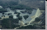
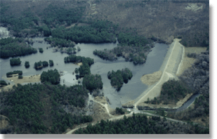
West Hill Dam Reserve is a U.S. Army Corps of Engineers flood control
project with a recreational park and wildlife management area located at Uxbridge, Massachusetts
. The West Hill Dam Project was completed in 1960. It is located on the West River
, one of the branches of the Blackstone River
which flows from Worcester, MA to Providence, RI. The West River originates in Grafton, Massachusetts
, at Cider Mill Pond and Silver Lake, near Upton, Massachusetts
, and the Upton State Forest. The dam is unique in that it isn't filled unless there is a flood.
West Hill Dam was built after devastating floods during the 1950s; it is intended to protect the Blackstone Valley
from future destructive flooding. The cities and towns downriver from Uxbridge, including Millville, Blackstone, Woonsocket, North Smithfield, Cumberland
, Lincoln
, Central Falls and Providence, Rhode Island
, suffered extensive flooding from the Blackstone during Hurricane Diane
in 1955. Hurricane Donna
tested this new dam in 1960 as the eyewall passed over.
The West Hill Dam is located in the Blackstone River Valley National Heritage Corridor
near the Blackstone River and Canal Heritage State Park
. Park rangers provide visitor assistance and offer scheduled interpretative programs. Fishing, hunting, and wildlife viewing opportunities are available year-round. The park has a recreation area, 34 picnic sites, one playground, a swimming area and five miles of hiking trails.
West Hill Dam (where the Army Corps project is based) is also the field office for the Charles River Natural Valley Storage Area
. It consists of scattered wetlands in the upper and middle Charles River watershed, between the towns of Bellingham and Needham. The wetlands provide flood storage area, fisheries, wildlife management, and recreation. The Charles River
is, of course, the well-known watercourse that flows into Boston Harbor
.
. Nearly all of its western slope is in Uxbridge, and this is where the dam is located. The town of Northbridge is immediately to the north of this site and includes some of the reservoir
trapped behind the West Hill Dam. West Hill and West Hill Dam are in the northeastern part of Uxbridge township. The actual summit of West Hill is in the adjacent town of Mendon. The federal reserve contains 567 acres in the townships of Uxbridge, Northbridge, and Upton, Massachusetts. The New England town
or township is is a unique municipality unit unlike those of any other geographic region of the United States.
Villages, established by the missionary, John Eliot
around 1640. Early water powered mills, including some downsream on the West River, and Blackstone River
, helped jumpstart America's industrial revolution
in this river valley region. The Blackstone Valley
is a New England
upland
region with elevations from approximately two hundred feet to over six hundred feet above sea level. West Hill Dam is located about thirty-four miles west-southwest of Boston
, and about fifteen miles southeast of Worcester.
Flood control
In communications, flood control is a feature of many communication protocols designed to prevent overwhelming of a destination receiver. Such controls can be implemented either in software or in hardware, and will often request that the message be resent after the receiver has finished...
project with a recreational park and wildlife management area located at Uxbridge, Massachusetts
Uxbridge, Massachusetts
Uxbridge is a town in Worcester County, Massachusetts, in the United States. It was first settled in 1662, incorporated in 1727 at Suffolk County, and named for the Earl of Uxbridge. Uxbridge is south-southeast of Worcester, north-northwest of Providence, and southwest of Boston. It is part of...
. The West Hill Dam Project was completed in 1960. It is located on the West River
West River (Massachusetts)
The West River, in the US state of Massachusetts, is a tributary of the Blackstone River.-Course:It originates in the towns of Grafton and Upton, Massachusetts, near the Upton State Forest, at Silver Lake and Cider Mill Pond in Grafton, and crosses into the eastern portion of Northbridge, passes...
, one of the branches of the Blackstone River
Blackstone River
The Blackstone River is a river in the U.S. states of Massachusetts and Rhode Island. It flows approximately 48 mi and drains a watershed of approximately 540 sq. mi...
which flows from Worcester, MA to Providence, RI. The West River originates in Grafton, Massachusetts
Grafton, Massachusetts
Grafton is a town in Worcester County, Massachusetts, United States. The population was 17,765 at the 2010 census. Grafton is the home of a Nipmuc village known as Hassanamisco Reservation, the Willard House and Clock Museum, and the Tufts University Cummings School of Veterinary Medicine...
, at Cider Mill Pond and Silver Lake, near Upton, Massachusetts
Upton, Massachusetts
Upton is a town in Worcester County, Massachusetts, United States. The population was 7,542 at the 2010 census.For geographic and demographic information on the census-designated place Upton-West Upton, please see the article Upton-West Upton, Massachusetts....
, and the Upton State Forest. The dam is unique in that it isn't filled unless there is a flood.
West Hill Dam was built after devastating floods during the 1950s; it is intended to protect the Blackstone Valley
Blackstone Valley
The Blackstone Valley or Blackstone River Valley is a region of Massachusetts and Rhode Island. It was a major contributor to the American Industrial Revolution...
from future destructive flooding. The cities and towns downriver from Uxbridge, including Millville, Blackstone, Woonsocket, North Smithfield, Cumberland
Cumberland, Rhode Island
Cumberland is a town in Providence County, Rhode Island, United States, incorporated in 1746. The population was 33,506 at the 2010 census.-History:...
, Lincoln
Lincoln, Rhode Island
Lincoln is a town in Providence County, Rhode Island, United States. The population was 21,105 at the 2010 census. Lincoln is located in northeastern Rhode Island, north of Providence....
, Central Falls and Providence, Rhode Island
Providence, Rhode Island
Providence is the capital and most populous city of Rhode Island and was one of the first cities established in the United States. Located in Providence County, it is the third largest city in the New England region...
, suffered extensive flooding from the Blackstone during Hurricane Diane
Hurricane Diane
Hurricane Diane was one of three hurricanes to hit North Carolina during the 1955 Atlantic hurricane season, striking an area that had been hit by Hurricane Connie five days earlier...
in 1955. Hurricane Donna
Hurricane Donna
Hurricane Donna in the 1960 Atlantic hurricane season was a Cape Verde-type hurricane which moved across the Leeward Islands, Puerto Rico, Hispanola, Cuba, The Bahamas, and every state on the East Coast of the United States...
tested this new dam in 1960 as the eyewall passed over.
The West Hill Dam is located in the Blackstone River Valley National Heritage Corridor
Blackstone River Valley National Heritage Corridor
The John H. Chafee Blackstone River Valley National Heritage Corridor is a National Heritage Corridor dedicated to the history of the early American Industrial Revolution, including mill towns stretching across 24 cities and towns near the river's course in Worcester County, Massachusetts and...
near the Blackstone River and Canal Heritage State Park
Blackstone River and Canal Heritage State Park
The Blackstone River and Canal Heritage State Park is a part of the State Park system of the Commonwealth of Massachusetts, managed by the Massachusetts Department of Conservation and Recreation...
. Park rangers provide visitor assistance and offer scheduled interpretative programs. Fishing, hunting, and wildlife viewing opportunities are available year-round. The park has a recreation area, 34 picnic sites, one playground, a swimming area and five miles of hiking trails.
West Hill Dam (where the Army Corps project is based) is also the field office for the Charles River Natural Valley Storage Area
Charles River Natural Valley Storage Area
The Charles River Natural Valley Storage Area comprises over of protected land in the middle and upper watershed of the Charles River in eastern Massachusetts in the United States. The lands were acquired by the United States Army Corps of Engineers and are managed by the Massachusetts Division...
. It consists of scattered wetlands in the upper and middle Charles River watershed, between the towns of Bellingham and Needham. The wetlands provide flood storage area, fisheries, wildlife management, and recreation. The Charles River
Charles River
The Charles River is an long river that flows in an overall northeasterly direction in eastern Massachusetts, USA. From its source in Hopkinton, the river travels through 22 cities and towns until reaching the Atlantic Ocean at Boston...
is, of course, the well-known watercourse that flows into Boston Harbor
Boston Harbor
Boston Harbor is a natural harbor and estuary of Massachusetts Bay, and is located adjacent to the city of Boston, Massachusetts. It is home to the Port of Boston, a major shipping facility in the northeast.-History:...
.
Geography of West Hill Dam
West Hill is the westernmost hill in MendonMendon, Massachusetts
Mendon is a town in Worcester County, Massachusetts, United States. The population was 5,839 at the 2010 census.Mendon is very historic and is now part of the Blackstone River Valley National Heritage Corridor, the oldest industrialized region in the United States.- Early history :The Nipmuc people...
. Nearly all of its western slope is in Uxbridge, and this is where the dam is located. The town of Northbridge is immediately to the north of this site and includes some of the reservoir
Reservoir
A reservoir , artificial lake or dam is used to store water.Reservoirs may be created in river valleys by the construction of a dam or may be built by excavation in the ground or by conventional construction techniques such as brickwork or cast concrete.The term reservoir may also be used to...
trapped behind the West Hill Dam. West Hill and West Hill Dam are in the northeastern part of Uxbridge township. The actual summit of West Hill is in the adjacent town of Mendon. The federal reserve contains 567 acres in the townships of Uxbridge, Northbridge, and Upton, Massachusetts. The New England town
New England town
The New England town is the basic unit of local government in each of the six New England states. Without a direct counterpart in most other U.S. states, New England towns are conceptually similar to civil townships in other states, but are incorporated, possessing powers like cities in other...
or township is is a unique municipality unit unlike those of any other geographic region of the United States.
Historic Context and Location
The West Hill area was one of fourteen sites of Praying IndianPraying Indian
Praying Indian is a 17th century term referring to Native Americans of New England who converted to Christianity. While many groups are referred to by this term, it is more commonly used for tribes that were organized into villages, known as praying towns by Puritan leader John Eliot.In 1646, the...
Villages, established by the missionary, John Eliot
John Eliot (missionary)
John Eliot was a Puritan missionary to the American Indians. His efforts earned him the designation “the Indian apostle.”-English education and Massachusetts ministry:...
around 1640. Early water powered mills, including some downsream on the West River, and Blackstone River
Blackstone River
The Blackstone River is a river in the U.S. states of Massachusetts and Rhode Island. It flows approximately 48 mi and drains a watershed of approximately 540 sq. mi...
, helped jumpstart America's industrial revolution
Industrial Revolution
The Industrial Revolution was a period from the 18th to the 19th century where major changes in agriculture, manufacturing, mining, transportation, and technology had a profound effect on the social, economic and cultural conditions of the times...
in this river valley region. The Blackstone Valley
Blackstone Valley
The Blackstone Valley or Blackstone River Valley is a region of Massachusetts and Rhode Island. It was a major contributor to the American Industrial Revolution...
is a New England
New England
New England is a region in the northeastern corner of the United States consisting of the six states of Maine, New Hampshire, Vermont, Massachusetts, Rhode Island, and Connecticut...
upland
Highland (geography)
The term highland or upland is used to denote any mountainous region or elevated mountainous plateau. Generally speaking, the term upland tends to be used for ranges of hills, typically up to 500-600m, and highland for ranges of low mountains.The Scottish Highlands refers to the mountainous...
region with elevations from approximately two hundred feet to over six hundred feet above sea level. West Hill Dam is located about thirty-four miles west-southwest of Boston
Boston
Boston is the capital of and largest city in Massachusetts, and is one of the oldest cities in the United States. The largest city in New England, Boston is regarded as the unofficial "Capital of New England" for its economic and cultural impact on the entire New England region. The city proper had...
, and about fifteen miles southeast of Worcester.
See also
- West River (Massachusetts)West River (Massachusetts)The West River, in the US state of Massachusetts, is a tributary of the Blackstone River.-Course:It originates in the towns of Grafton and Upton, Massachusetts, near the Upton State Forest, at Silver Lake and Cider Mill Pond in Grafton, and crosses into the eastern portion of Northbridge, passes...
- Uxbridge, MassachusettsUxbridge, MassachusettsUxbridge is a town in Worcester County, Massachusetts, in the United States. It was first settled in 1662, incorporated in 1727 at Suffolk County, and named for the Earl of Uxbridge. Uxbridge is south-southeast of Worcester, north-northwest of Providence, and southwest of Boston. It is part of...
- Northbridge, MassachusettsNorthbridge, MassachusettsNorthbridge is a town in Worcester County, Massachusetts, United States. The population was 15,707 at the 2010 census. The Northbridge Town Hall is located at 7 Main Street in Whitinsville. The town is now a part of the Blackstone River Valley National Heritage Corridor, of the National Park...
- Army Corps of Engineers
- Blackstone ValleyBlackstone ValleyThe Blackstone Valley or Blackstone River Valley is a region of Massachusetts and Rhode Island. It was a major contributor to the American Industrial Revolution...
- Blackstone River and Canal Heritage State ParkBlackstone River and Canal Heritage State ParkThe Blackstone River and Canal Heritage State Park is a part of the State Park system of the Commonwealth of Massachusetts, managed by the Massachusetts Department of Conservation and Recreation...
- Charles River Natural Valley Storage AreaCharles River Natural Valley Storage AreaThe Charles River Natural Valley Storage Area comprises over of protected land in the middle and upper watershed of the Charles River in eastern Massachusetts in the United States. The lands were acquired by the United States Army Corps of Engineers and are managed by the Massachusetts Division...
- West Hill Dam, Master Plan