

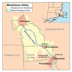
Blackstone River Valley National Heritage Corridor
Encyclopedia
Mill town
A mill town, also known as factory town or mill village, is typically a settlement that developed around one or more mills or factories .- United Kingdom:...
s stretching across 24 cities and towns (400,000 acres (1,620 km²) in total) near the river's course in Worcester County, Massachusetts
Worcester County, Massachusetts
-Demographics:In 1990 Worcester County had a population of 709,705.As of the census of 2000, there were 750,963 people, 283,927 households, and 192,502 families residing in the county. The population density was 496 people per square mile . There were 298,159 housing units at an average density...
and Providence County, Rhode Island
Providence County, Rhode Island
-Demographics:As of the census of 2000, there were 621,602 people, 239,936 households, and 152,839 families residing in the county. The population density was 1,504 people per square mile . There were 253,214 housing units at an average density of 613 per square mile...
. It makes up a historical area in the Blackstone Valley
Blackstone Valley
The Blackstone Valley or Blackstone River Valley is a region of Massachusetts and Rhode Island. It was a major contributor to the American Industrial Revolution...
and is named for the late US Senator
United States Senate
The United States Senate is the upper house of the bicameral legislature of the United States, and together with the United States House of Representatives comprises the United States Congress. The composition and powers of the Senate are established in Article One of the U.S. Constitution. Each...
from Rhode Island John Chafee
John Chafee
John Lester Hubbard Chafee was an American politician. He served as an officer in the United States Marine Corps, as the 66th Governor of Rhode Island, as the Secretary of the Navy, and as a United States Senator.-Early life and family:...
. Rhode Island
Rhode Island
The state of Rhode Island and Providence Plantations, more commonly referred to as Rhode Island , is a state in the New England region of the United States. It is the smallest U.S. state by area...
's U.S. Senator Jack Reed has filed federal legislation to add The Blackstone Valley as a National Historic Park.
History
The National Corridor was designated by an Act of CongressAct of Congress
An Act of Congress is a statute enacted by government with a legislature named "Congress," such as the United States Congress or the Congress of the Philippines....
on November 10, 1986 to preserve and interpret for present and future generations the unique and significant value of the Blackstone Valley. It includes cities, towns, villages and almost one million people. The Federal government does not own or manage any of the land or resources in the corridor as it does in the more traditional national parks. Instead the National Park Service
National Park Service
The National Park Service is the U.S. federal agency that manages all national parks, many national monuments, and other conservation and historical properties with various title designations...
, two state governments, dozens of local municipalities, businesses, nonprofit historical and environmental organizations, educational institutions, many private citizens, and a unifying commission all work together in partnerships to protect the Valley's special identity and prepare for its future.
The Blackstone River Bikeway
Blackstone River Bikeway
right|thumb|400px|The Blackstone River Bikeway in October 2006, approximately one mile south of the Martin St. BridgeThe Blackstone River Bikeway is a planned paved rail trail defining the course of the East Coast Greenway through the Blackstone Valley from Worcester, Massachusetts to Providence,...
is a planned 48 miles (77.2 km) paved rail trail
Rail trail
A rail trail is the conversion of a disused railway easement into a multi-use path, typically for walking, cycling and sometimes horse riding. The characteristics of former tracks—flat, long, frequently running through historical areas—are appealing for various development. The term sometimes also...
defining the course of the East Coast Greenway
East Coast Greenway
The East Coast Greenway, or ECG, is a project to create a nearly urban path linking the major cities of the Atlantic coast of the United States, from Calais, Maine, to Key West, Florida, for non-motorized human transportation...
through the National Corridor. As of mid-2009, approximately 10 miles (16.1 km) of the Bikeway has been completed in Rhode Island, 2.5 miles (4 km) in Massachusetts.
On October 12, 2006 the National Heritage Areas Act of 2006 was signed by the President, enacting it as Public Law Number 109-338. This legislation extends the Corridor Commission for five years until October 12, 2011.
On July 18, 2011 a report recommended the corridor for national park status.
Visitor centers
- Blackstone Valley Visitor Center, Pawtucket, Rhode IslandPawtucket, Rhode IslandPawtucket is a city in Providence County, Rhode Island, United States. The population was 71,148 at the 2010 census. It is the fourth largest city in the state.-History:...
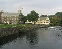
(operated by the Blackstone Valley Tourism Council) - Museum of Work and CultureMuseum of Work and CultureThe Museum of Work and Culture is a museum in Woonsocket, Rhode Island, that features exhibits focusing on the city's textile manufacturing heritage...
, Woonsocket, Rhode IslandWoonsocket, Rhode IslandWoonsocket is a city in Providence County, Rhode Island, United States. The population was 41,186 at the 2010 census, making it the sixth largest city in the state. Woonsocket lies directly south of the Massachusetts border....
(operated by the Rhode Island Historical SocietyRhode Island Historical SocietyThe Rhode Island Historical Society is a privately endowed membership organization, founded in 1822, dedicated to collecting, preserving, and sharing the history of Rhode Island...
) - River Bend Farm Visitor Center at Blackstone River and Canal Heritage State ParkBlackstone River and Canal Heritage State ParkThe Blackstone River and Canal Heritage State Park is a part of the State Park system of the Commonwealth of Massachusetts, managed by the Massachusetts Department of Conservation and Recreation...
, Uxbridge, MassachusettsUxbridge, MassachusettsUxbridge is a town in Worcester County, Massachusetts, in the United States. It was first settled in 1662, incorporated in 1727 at Suffolk County, and named for the Earl of Uxbridge. Uxbridge is south-southeast of Worcester, north-northwest of Providence, and southwest of Boston. It is part of...
(operated by Massachusetts Department of Conservation and Recreation) - Broad Meadow Brook Sanctuary, Worcester, MassachusettsWorcester, MassachusettsWorcester is a city and the county seat of Worcester County, Massachusetts, United States. Named after Worcester, England, as of the 2010 Census the city's population is 181,045, making it the second largest city in New England after Boston....
(operated by the Massachusetts Audubon SocietyMassachusetts Audubon SocietyThe Massachusetts Audubon Society, founded in 1896 by Harriet Hemenway and headquartered in Lincoln, Massachusetts, is a nonprofit organization dedicated to "Protecting the nature of Massachusetts." Mass Audubon is independent of the National Audubon Society, and in fact was founded...
)
Corridor cities and towns
- Massachusetts
- BlackstoneBlackstone, MassachusettsBlackstone is a town in Worcester County, Massachusetts, United States. The population was 9,026 at the 2010 census. It is formally a part of the Providence metropolitan area. Blackstone is the only municipality in Massachusetts to employ automatic cameras in traffic enforcement.- History :This...
- DouglasDouglas, MassachusettsDouglas is a town in Worcester County, Massachusetts, United States. The population was 8,471 as of the 2010 census. It includes the sizable Douglas State Forest, managed by the Massachusetts Department of Conservation and Recreation .- History :...
- GraftonGrafton, MassachusettsGrafton is a town in Worcester County, Massachusetts, United States. The population was 17,765 at the 2010 census. Grafton is the home of a Nipmuc village known as Hassanamisco Reservation, the Willard House and Clock Museum, and the Tufts University Cummings School of Veterinary Medicine...
- HopedaleHopedale, MassachusettsHopedale is a town in Worcester County, Massachusetts, United States. The population was 5,911 at the 2010 census.For geographic and demographic information on the census-designated place Hopedale, please see the article Hopedale , Massachusetts....
- LeicesterLeicester, MassachusettsLeicester is a town in Worcester County, Massachusetts, United States. The population was 10,970 at the 2010 census.-History:Leicester was first settled in 1713 and was officially incorporated in 1714....
- MendonMendon, MassachusettsMendon is a town in Worcester County, Massachusetts, United States. The population was 5,839 at the 2010 census.Mendon is very historic and is now part of the Blackstone River Valley National Heritage Corridor, the oldest industrialized region in the United States.- Early history :The Nipmuc people...
- MillburyMillbury, MassachusettsMillbury is a town in Worcester County, Massachusetts, United States. The population was 13,261 at the 2010 census. The town is part of the Blackstone River Valley National Heritage Corridor.-History:...
- MillvilleMillville, MassachusettsMillville is a town in Worcester County, Massachusetts, United States. The population was 3,190 at the 2010 census. It is part of the Providence metropolitan area.- History :...
- NorthbridgeNorthbridge, MassachusettsNorthbridge is a town in Worcester County, Massachusetts, United States. The population was 15,707 at the 2010 census. The Northbridge Town Hall is located at 7 Main Street in Whitinsville. The town is now a part of the Blackstone River Valley National Heritage Corridor, of the National Park...
and its village of WhitinsvilleWhitinsville, MassachusettsWhitinsville is an unincorporated village and census-designated place on the Mumford River, a tributary of the Blackstone River, in the town of Northbridge in Worcester County, Massachusetts, United States. The population was 6,704 at the 2010 census. Whitinsville is pronounced as if it were... - SuttonSutton, Massachusetts-Library:The Sutton Free Library was established in 1876. In fiscal year 2008, the town of Sutton spent 0.7% of its budget on its public library—some $18 per person.-Education:...
- UptonUpton, MassachusettsUpton is a town in Worcester County, Massachusetts, United States. The population was 7,542 at the 2010 census.For geographic and demographic information on the census-designated place Upton-West Upton, please see the article Upton-West Upton, Massachusetts....
- UxbridgeUxbridge, MassachusettsUxbridge is a town in Worcester County, Massachusetts, in the United States. It was first settled in 1662, incorporated in 1727 at Suffolk County, and named for the Earl of Uxbridge. Uxbridge is south-southeast of Worcester, north-northwest of Providence, and southwest of Boston. It is part of...
- WorcesterWorcester, MassachusettsWorcester is a city and the county seat of Worcester County, Massachusetts, United States. Named after Worcester, England, as of the 2010 Census the city's population is 181,045, making it the second largest city in New England after Boston....
- Blackstone
- Rhode Island
- BurrillvilleBurrillville, Rhode IslandBurrillville is a town in Providence County, Rhode Island, United States. It was incorporated as an independent municipality on November 17, 1806 when the Rhode Island General Assembly authorized the residents of then North Glocester to elect its own officers. The population was 15,955 at the 2010...
- Central FallsCentral Falls, Rhode IslandCentral Falls is a city in Providence County, Rhode Island, United States. The population was 19,376 at the 2010 census. With an area of only , it is the smallest and most densely populated city in the smallest state, and the thirty-second most densely populated incorporated place in the United...
- CumberlandCumberland, Rhode IslandCumberland is a town in Providence County, Rhode Island, United States, incorporated in 1746. The population was 33,506 at the 2010 census.-History:...
- East ProvidenceEast Providence, Rhode IslandEast Providence is a city in Providence County, Rhode Island, United States. The population was 47,037 at the 2010 census, making it the fifth largest city in the state.-Geography:East Providence is located at ....
- GlocesterGlocester, Rhode IslandGlocester is a town in Providence County, Rhode Island, United States. The population was 9,746 as of the 2010 census. The villages of Chepachet and Harmony are in Glocester. Putnam Pike Glocester is a town in Providence County, Rhode Island, United States. The population was 9,746 as of the 2010...
- LincolnLincoln, Rhode IslandLincoln is a town in Providence County, Rhode Island, United States. The population was 21,105 at the 2010 census. Lincoln is located in northeastern Rhode Island, north of Providence....
- North SmithfieldNorth Smithfield, Rhode IslandNorth Smithfield is a town in Providence County, Rhode Island, United States, settled as a farming community in 1666 and incorporated into its present form in 1871. North Smithfield includes the historic villages of Forestdale, Primrose, Waterford, Branch Village, Union Village, Park Square, and...
- PawtucketPawtucket, Rhode IslandPawtucket is a city in Providence County, Rhode Island, United States. The population was 71,148 at the 2010 census. It is the fourth largest city in the state.-History:...
- ProvidenceProvidence, Rhode IslandProvidence is the capital and most populous city of Rhode Island and was one of the first cities established in the United States. Located in Providence County, it is the third largest city in the New England region...
- SmithfieldSmithfield, Rhode IslandSmithfield is a town in Providence County, Rhode Island, United States. It includes the historic villages of Esmond, Georgiaville, Mountaindale, Hanton City, Stillwater and Greenville...
- WoonsocketWoonsocket, Rhode IslandWoonsocket is a city in Providence County, Rhode Island, United States. The population was 41,186 at the 2010 census, making it the sixth largest city in the state. Woonsocket lies directly south of the Massachusetts border....
- Burrillville
See also
- Greater Worcester Land TrustGreater Worcester Land TrustFounded in Worcester, Massachusetts in 1987, the Greater Worcester Land Trust is a non-profit land conservation organization dedicated to the protection of important lands in Worcester and the surrounding towns...
and list of other conservation organizations operating in the Blackstone River Valley
External links
- Official NPS site
- Legislative History of National Corridor
- Blackstone Valley Institute (planning resources)
- Blackstone River Valley Corridor Keepers (preservation group)
- Highway of Commerce: The Blackstone Canal, Worcester Historical MuseumWorcester Historical MuseumThe Worcester Historical Museum, located in downtown Worcester, Massachusetts, was founded in 1875. This museum is the only institution devoted entirely to local history and artifacts. The scope of their collection ranges from colonial to twentieth century, encompassing manuscripts, textiles,...
, 2005 - Historic American Building Survey