
Norfolk Coast AONB
Encyclopedia
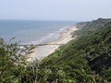
The Norfolk Coast Area of Outstanding Natural Beauty (AONB) covers over 450 km2 of coastal and agricultural land from the The Wash
in the west through coastal marshes and cliffs to the sand dunes at Winterton
in the east.
The area includes; Hunstanton
, Wells-next-the-Sea
, Blakeney
, Blakeney Point
, Sheringham
, Cromer
and Mundesley
. The terrain behind the coast is rolling chalk
land and glacial moraine
, including the almost 300 foot (90m) high Cromer Ridge. East of Weybourne
there is severe coastal erosion.
National Nature Reserves in the AONB include the world-famous bird reserves at Cley Marshes
and Titchwell
. The Winterton Dunes
are one of the country's finest dune
systems. The Heritage Coast stretch of the AONB is a Site of Special Scientific Interest
, a candidate Special Area for Conservation (SAC) and a Special Protection Area. The Peddars Way
and Norfolk Coast Path National Trail pass through the AONB.
The Wash
The Wash is the square-mouthed bay and estuary on the northwest margin of East Anglia on the east coast of England, where Norfolk meets Lincolnshire. It is among the largest estuaries in the United Kingdom...
in the west through coastal marshes and cliffs to the sand dunes at Winterton
Winterton Dunes
Winterton Dunes is an extensive dune system on the east coast of Norfolk, England, which has been designated as a National Nature Reserve and is within the Norfolk Coast AONB....
in the east.
The area includes; Hunstanton
Hunstanton
Hunstanton, often pronounced by locals as and known colloquially as 'Sunny Hunny', is a seaside town in Norfolk, England, facing The Wash....
, Wells-next-the-Sea
Wells-next-the-Sea
Wells-next-the-Sea, known locally simply as Wells, is a town, civil parish and seaport situated on the North Norfolk coast in England.The civil parish has an area of and in the 2001 census had a population of 2,451 in 1,205 households...
, Blakeney
Blakeney, Norfolk
Blakeney is a coastal village and civil parish in the English county of Norfolk. Blakeney lies within the Norfolk Coast AONB and the North Norfolk Heritage Coast. The North Norfolk Coastal Path passes through the village...
, Blakeney Point
Blakeney Point
Blakeney Point is a shingle spit on the coast of North Norfolk north of the village of Blakeney in the English county of Norfolk. It is managed by the National Trust as part of its Blakeney National Nature Reserve and within the Norfolk Coast Area of Outstanding Natural Beauty.-Description:Blakeney...
, Sheringham
Sheringham
Sheringham is a seaside town in Norfolk, England, west of Cromer.The motto of the town, granted in 1953 to the Sheringham Urban District Council, is Mare Ditat Pinusque Decorat, Latin for "The sea enriches and the pine adorns"....
, Cromer
Cromer
Cromer is a coastal town and civil parish in north Norfolk, England. The local government authority is North Norfolk District Council, whose headquarters is in Holt Road in the town. The town is situated 23 miles north of the county town, Norwich, and is 4 miles east of Sheringham...
and Mundesley
Mundesley
Mundesley is a coastal village and a civil parish in the English county of Norfolk. The village is 20.3 miles north-north east of Norwich, 7.3 miles south east of Cromer and 136 miles north east of London. The village lies 5.6 miles north-north east of the town of North Walsham. The nearest...
. The terrain behind the coast is rolling chalk
Chalk
Chalk is a soft, white, porous sedimentary rock, a form of limestone composed of the mineral calcite. Calcite is calcium carbonate or CaCO3. It forms under reasonably deep marine conditions from the gradual accumulation of minute calcite plates shed from micro-organisms called coccolithophores....
land and glacial moraine
Moraine
A moraine is any glacially formed accumulation of unconsolidated glacial debris which can occur in currently glaciated and formerly glaciated regions, such as those areas acted upon by a past glacial maximum. This debris may have been plucked off a valley floor as a glacier advanced or it may have...
, including the almost 300 foot (90m) high Cromer Ridge. East of Weybourne
Weybourne
Weybourne is a fishing resort on the North Norfolk and has the postcode prefix of NR25. The village straddles the A149 coast road and is three miles west of Sheringham, within the Norfolk Coast AONB. Weybourne is mentioned in the Domesday book and in that survey it is called Wabrume...
there is severe coastal erosion.
National Nature Reserves in the AONB include the world-famous bird reserves at Cley Marshes
Cley Marshes
Cley Marshes is a national nature reserve in Norfolk, England, adjacent to the village of Cley next the Sea.Cley Marshes was purchased by the Norfolk Wildlife Trust in 1926 to be held "in perpetuity as a bird breeding sanctuary". Cley is renowned as a birdwatching site, both for the resident...
and Titchwell
Titchwell
Titchwell is a village and civil parish in the English county of Norfolk. It is situated on the north Norfolk coast some west of the village of Brancaster, north-east of the seaside resort of Hunstanton, north of the town of King's Lynn and north-west of the city of Norwich.The civil parish has...
. The Winterton Dunes
Winterton Dunes
Winterton Dunes is an extensive dune system on the east coast of Norfolk, England, which has been designated as a National Nature Reserve and is within the Norfolk Coast AONB....
are one of the country's finest dune
Dune
In physical geography, a dune is a hill of sand built by wind. Dunes occur in different forms and sizes, formed by interaction with the wind. Most kinds of dunes are longer on the windward side where the sand is pushed up the dune and have a shorter "slip face" in the lee of the wind...
systems. The Heritage Coast stretch of the AONB is a Site of Special Scientific Interest
Site of Special Scientific Interest
A Site of Special Scientific Interest is a conservation designation denoting a protected area in the United Kingdom. SSSIs are the basic building block of site-based nature conservation legislation and most other legal nature/geological conservation designations in Great Britain are based upon...
, a candidate Special Area for Conservation (SAC) and a Special Protection Area. The Peddars Way
Peddars Way
The Peddars Way is a long distance footpath in Norfolk, England. It is 46 miles long and follows the route of a Roman road. It has been suggested by more than one writer that it was not created by the Romans but was an ancient trackway, a branch or extension of the Icknield Way, used and...
and Norfolk Coast Path National Trail pass through the AONB.