

Randa rockslides
Encyclopedia
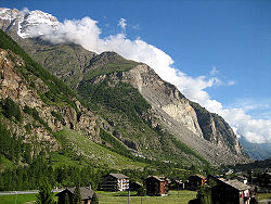
Mattertal
The Matter Valley is located in southwestern Switzerland, south of the Rhone valley in the canton of Valais. The village of Zermatt is the most important settlement of the valley, which is surrounded by many four-thousanders, including the Matterhorn.-Geography:Located in the Pennine Alps, the...
of Switzerland
Switzerland
Switzerland name of one of the Swiss cantons. ; ; ; or ), in its full name the Swiss Confederation , is a federal republic consisting of 26 cantons, with Bern as the seat of the federal authorities. The country is situated in Western Europe,Or Central Europe depending on the definition....
. The rockslides released a cumulative volume of approximately 30 million cubic meters of debris, with each of the rockslide stages occurring over several hours. Slide debris buried key regional transportation lines including the road and railway leading to Zermatt
Zermatt
Zermatt is a municipality in the district of Visp in the German-speaking section of the canton of Valais in Switzerland. It has a population of about 5,800 inhabitants....
, and dammed the Mattervispa river which eventually flooded a portion of the town of Randa upstream. There were no fatalities resulting from either of the rockslide events, though livestock, farmhouses and holiday homes were destroyed.
Geological Situation
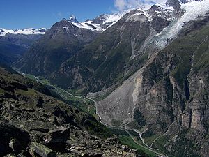
The Matter valley in the region of Randa exhibits classical morphology of glacial erosion, with steep rock walls and a wide valleyValley
In geology, a valley or dale is a depression with predominant extent in one direction. A very deep river valley may be called a canyon or gorge.The terms U-shaped and V-shaped are descriptive terms of geography to characterize the form of valleys...
bottom creating the common U-shaped form. Cliffs adjacent to the valley are exceptionally high, rising vertically some 800 m, while the nearby peaks of the Weisshorn
Weisshorn
The Weisshorn is a mountain in the Pennine Alps, in Switzerland. With its summit, it is one of the major peaks in the Alps and overtops the nearby Matterhorn by some 30 metres. It was first climbed in 1861 from Randa by John Tyndall, accompanied by the guides J.J...
and Dom sit 3000 m above the town of Randa.
Crystalline rocks of the slide source region belong to the Siviez–Mischabel nappe and primarily include a competent
Competence (geology)
In geology competence refers to the degree of resistance of rocks to either erosion or deformation in terms of relative mechanical strength. In mining 'competent rocks' are those in which an unsupported opening can be made. Competent rocks are more commonly exposed at outcrop as they tend to form...
orthogneiss
Gneiss
Gneiss is a common and widely distributed type of rock formed by high-grade regional metamorphic processes from pre-existing formations that were originally either igneous or sedimentary rocks.-Etymology:...
in the lower half of the slope overlain by highly-jointed paragneisses
Gneiss
Gneiss is a common and widely distributed type of rock formed by high-grade regional metamorphic processes from pre-existing formations that were originally either igneous or sedimentary rocks.-Etymology:...
and schist
Schist
The schists constitute a group of medium-grade metamorphic rocks, chiefly notable for the preponderance of lamellar minerals such as micas, chlorite, talc, hornblende, graphite, and others. Quartz often occurs in drawn-out grains to such an extent that a particular form called quartz schist is...
s (Willenberg et al., 2008a). Foliation
Foliation (geology)
Foliation is any penetrative planar fabric present in rocks. Foliation is common to rocks affected by regional metamorphic compression typical of orogenic belts. Rocks exhibiting foliation include the standard sequence formed by the prograde metamorphism of mudrocks; slate, phyllite, schist and...
dips gently to the west / southwest (into to the slope at the rockslide), cutting across the north-south trending Matter valley.
The site of the 1991 rockslides sits on a nose of rock on the western wall of the Matter valley, which has been significantly incised to the south by the Bis glacier. To the south and west of the eventual rockslides, an older progressive slope instability had developed leaving a noticeable scarp and debris cone. This scarp would eventually be cut by the 1991 rockslides.
Rockslides of 1991
The 1991 rockslides at Randa consisted of two separate collapse events on April 18 and May 9, which released in total a cumulative volume of approximately 30 million cubic meters of rock. The elevation of the top of the scarp is 2320 m (7610 ft), while the elevation of deposit toe is 1320 m (4330 ft).Accelerating occurrences of small rockfall
Rockfall
Rockfall or rock-fall refers to quantities of rock falling freely from a cliff face. A rockfall is a fragment of rock detached by sliding, toppling, or falling, that falls along a vertical or sub-vertical cliff, proceeds down slope by bouncing and flying along ballistic trajectories or by rolling...
s from the cliff in the decades preceding the slides gave indication of deeper movements, and fallen debris had eventually destroyed much of the forest beneath the cliff (Sartori et al., 2003). Precursory events noted immediately prior to the April, 1991 rockslide included explosive ruptures of rock slabs and new forceful water discharges from the face (Schindler et al., 1993).
April 18, 1991: This primary rockslide event occurred over the span of a few hours time, producing a large steep debris cone and a thick layer of dust over the valley. The rockslide consisted of a progressive succession of smaller collapses and block failures involving first the lower and more competent orthogneiss, followed by retrogressive collapse of the highly-jointed paragneiss above (Schindler et al., 1993). The total volume released during this rockslide phase was estimated to be 22 million cubic meters. Had this volume been released instantaneously, a devastating rock avalanche and far reaching deposit would have resulted. A lesser failure followed on April 22.
May 9, 1991: Monitoring of deformation and microseismic activity led to accurate anticipation of this follow up rockslide event. The rockslide again occurred in a progressive manner over the course of a few hours, involving many small volume collapse events mostly within the upper paragneiss material (Schindler et al., 1993). These failures resulted in retreat and reduced the inclination of the upper part of the rockslide scarp. The total volume released in this second phase was estimated to be 7 million cubic meters.
No one trigger can be conclusively assigned as responsible for the Randa rockslides of 1991. The area has experienced a long history of moderate seismicity, but no significant earthquakes immediately preceded the failures. A warm period producing ample snow melt occurred in the days prior to the April rockslide, and water could be seen emanating from springs on the rock face. Further, a period of rapid cooling occurred just one day before the April slide. However, it is unknown if this series of events combined to act as an exceptional trigger, or if they were rather part of the normal seasonal climatic and hydraulic cycles (Sartori et al., 2003).
Damage and Remediation
The road and railGlacier Express
The Glacier Express is an express train connecting railway stations of the two major mountain resorts of St. Moritz and Zermatt in the Swiss Alps. The train is operated jointly by the Matterhorn Gotthard Bahn and Rhaetian Railway...
line through the Matter valley are important tourist routes for visitors to the Matterhorn
Matterhorn
The Matterhorn , Monte Cervino or Mont Cervin , is a mountain in the Pennine Alps on the border between Switzerland and Italy. Its summit is 4,478 metres high, making it one of the highest peaks in the Alps. The four steep faces, rising above the surrounding glaciers, face the four compass points...
region. These transportation avenues were both interrupted by the April 18 rockslide. The May 9 event further cemented the problem. The rail line was buried for 800 m, while 200 m of the road was covered (Quanterra.org). The road and rail line have both since been re-routed to circumnavigate the rockslide deposit.
The rockslide debris also dammed the Mattervispa river, a problem that was again compounded by the second event. Work digging through the blockage was begun immediately, but heavy rain and snow melt eventually resulted in flooding of a portion of the town of Randa upstream. A channel was eventually cut and the water receded. The Swiss army
Military of Switzerland
The Swiss Armed Forces perform the roles of Switzerland's militia and regular army. Under the country's militia system, professional soldiers constitute about 5 percent of military personnel; the rest are male citizen conscripts 19 to 34 years old...
had deployed a floating bridge in anticipation of the flooding, which successfully allowed the road upstream of the deposit to remain open. A nearly 4 km long bypass tunnel
Tunnel
A tunnel is an underground passageway, completely enclosed except for openings for egress, commonly at each end.A tunnel may be for foot or vehicular road traffic, for rail traffic, or for a canal. Some tunnels are aqueducts to supply water for consumption or for hydroelectric stations or are sewers...
was then bored into the wall beneath the cliff to prevent any future floods.
Continued Movement
Several million cubic meters of rock above and behind the scarp of the 1991 rockslides remains unstable today, moving towards the valley at rates up to 2 cm per year. This situation is not considered to be a critical hazard at the moment, but movements are carefully monitored and studied.Monitoring and Geoscience
The Randa rockslide has long been the site of intensive geological, geotechnical, and geophysical research. Following the April, 1991 failure, monitoring instrumentation was installed that helped successfully predict the impending May rockslide. The site has since been monitored by ValaisValais
The Valais is one of the 26 cantons of Switzerland in the southwestern part of the country, around the valley of the Rhône from its headwaters to Lake Geneva, separating the Pennine Alps from the Bernese Alps. The canton is one of the drier parts of Switzerland in its central Rhône valley...
Kantonal authorities.
Since 2001, researchers from the Department of Earth Science at the Swiss Federal Institute of Technology
ETH Zurich
The Swiss Federal Institute of Technology Zurich or ETH Zürich is an engineering, science, technology, mathematics and management university in the City of Zurich, Switzerland....
(ETH, Zurich) have conducted studies into the cause and nature of the ongoing deformations. New monitoring and exploration techniques, combined with traditional geological investigations have revealed important insights into the process of progressive failure driving the current instability (Eberhardt et al., 2004; Heincke et al., 2006; Spillmann et al., 2007; Willenberg et al., 2008a,b).
Current information about the research activities of the ETH at the Randa “in-situ laboratory” can be found at: http://www.rockslide.ethz.ch/
External links
- http://www.rockslide.ethz.ch/
- http://www.quanterra.org/guide/guide1_18.htm
- http://www.vaw.ethz.ch/applied_research/protection/flood_protection/fb_randa_rock_falls_in_1991
- The 1991 catastrophic failure events