
Victoria Island
Encyclopedia
Victoria Island is an island in the Canadian Arctic Archipelago
and straddles the boundary between Nunavut
and the Northwest Territories
of Canada
. It is the eighth largest island in the world, and at 217291 km² (83,897 sq mi) is Canada's second largest island. It is nearly double the size of Newfoundland (111390 km² (43,008 sq mi)), and is slightly larger than the island of Great Britain
(209331 km² (80,823 sq mi)). The western third of the island belongs to the Inuvik Region in the Northwest Territories; the remainder is part of Nunavut's Kitikmeot Region
.
It should not be confused with the smaller Vancouver Island
, which is home to Victoria, British Columbia
, the capital of that Canadian province.
in 1826. In 1838 and 1839 Peter Warren Dease
and Thomas Simpson
explored its southeast coast, while John Rae
charted its entire south coast in 1851. Its northwest and west coasts were charted by men from Robert McClure
's expedition in 1850 and 1851.
One of Roald Amundsen
's men, Godfred Hansen, charted its east coast as far as Cape Nansen in 1905, and in 1916 and 1917 Storker T. Storkerson, of Vilhjalmur Stefansson
's Canadian Arctic Expedition
, charted its northeast coast, discovering the Storkerson Peninsula.
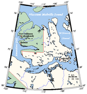
lies to the north, and the M'Clintock Channel
and Victoria Strait
lie eastward. On the west are Amundsen Gulf
and Banks Island
, which is separated from Victoria by a long sound called the Prince of Wales Strait
. To the south (from west to east) lies the Dolphin and Union Strait
, Austin Bay
, Coronation Gulf
and the Dease Strait
.
The southern waterways, and sometimes the Prince of Wales Strait, form part of the disputed Northwest Passage
which the Government of Canada
claims are Canadian Internal Waters
, while other nations state they are either territorial waters
or international waters
.
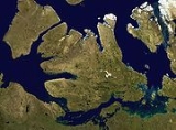
Victoria Island is an island of peninsulas, having a heavily indented coastline with many inlet
s. In the east, pointing northwards, is the Storkerson Peninsula, which ends with the Goldsmith Channel
, the body of water separating Victoria from Stefansson Island
. The Storkerson Peninsula is separated from the island's north-central areas by Hadley Bay, a major inlet. Another, broad peninsula is found in the north, Prince Albert Peninsula
. This ends at the Prince of Wales Strait. In the south, and pointing westwards, is the Wollaston Peninsula
, separated from the island's central areas by Prince Albert Sound. The island as a whole coincidentally resembles a stylized maple leaf
, the main Canadian symbol
.
 The highest point of Victoria Island is 655 m (2,149 ft) in the Shaler Mountains
in the north-central region. Located in the southeast, just north of Cambridge Bay is Ferguson Lake
with an area of 562 km² (217 sq mi) is the largest lake on the island.
In the Canada 2006 Census
the population of the island was 1,875; 1,477 in Nunavut and 398 in the Northwest Territories. Of the two settlements
on the island the largest is Cambridge Bay
, which lies on the south-east coast and is in Nunavut. Ulukhaktok
is on the west coast and is in the Northwest Territories. Trading post
s, such as Fort Collinson
on the northwest coast, have long since been abandoned.
The island is named after Queen Victoria
, the Canadian sovereign from 1867 to 1901. The features bearing the name "Prince Albert" are named after her consort.
While Victoria Island is part of Canada, it is over 2000 km (1,242.7 mi) from the city of Victoria, British Columbia
, which is on Vancouver Island
in the Pacific Ocean
. There is also a smaller Victoria Island in Nunavut, located in Amadjuak Lake
on Baffin Island
.
Canadian Arctic Archipelago
The Canadian Arctic Archipelago, also known as the Arctic Archipelago, is a Canadian archipelago north of the Canadian mainland in the Arctic...
and straddles the boundary between Nunavut
Nunavut
Nunavut is the largest and newest federal territory of Canada; it was separated officially from the Northwest Territories on April 1, 1999, via the Nunavut Act and the Nunavut Land Claims Agreement Act, though the actual boundaries had been established in 1993...
and the Northwest Territories
Northwest Territories
The Northwest Territories is a federal territory of Canada.Located in northern Canada, the territory borders Canada's two other territories, Yukon to the west and Nunavut to the east, and three provinces: British Columbia to the southwest, and Alberta and Saskatchewan to the south...
of Canada
Canada
Canada is a North American country consisting of ten provinces and three territories. Located in the northern part of the continent, it extends from the Atlantic Ocean in the east to the Pacific Ocean in the west, and northward into the Arctic Ocean...
. It is the eighth largest island in the world, and at 217291 km² (83,897 sq mi) is Canada's second largest island. It is nearly double the size of Newfoundland (111390 km² (43,008 sq mi)), and is slightly larger than the island of Great Britain
Great Britain
Great Britain or Britain is an island situated to the northwest of Continental Europe. It is the ninth largest island in the world, and the largest European island, as well as the largest of the British Isles...
(209331 km² (80,823 sq mi)). The western third of the island belongs to the Inuvik Region in the Northwest Territories; the remainder is part of Nunavut's Kitikmeot Region
Kitikmeot Region, Nunavut
Kitikmeot Region is an administrative region of Nunavut, Canada. It consists of the southern and eastern parts of Victoria Island with the adjacent part of the mainland as far as the Boothia Peninsula, together with King William Island and the southern portion of Prince of Wales Island...
.
It should not be confused with the smaller Vancouver Island
Vancouver Island
Vancouver Island is a large island in British Columbia, Canada. It is one of several North American locations named after George Vancouver, the British Royal Navy officer who explored the Pacific Northwest coast of North America between 1791 and 1794...
, which is home to Victoria, British Columbia
Victoria, British Columbia
Victoria is the capital city of British Columbia, Canada and is located on the southern tip of Vancouver Island off Canada's Pacific coast. The city has a population of about 78,000 within the metropolitan area of Greater Victoria, which has a population of 360,063, the 15th most populous Canadian...
, the capital of that Canadian province.
History
The first European to see the island was John RichardsonJohn Richardson (naturalist)
Sir John Richardson was a Scottish naval surgeon, naturalist and arctic explorer.Richardson was born at Dumfries. He studied medicine at Edinburgh University, and became a surgeon in the navy in 1807. He traveled with John Franklin in search of the Northwest Passage on the Coppermine Expedition of...
in 1826. In 1838 and 1839 Peter Warren Dease
Peter Warren Dease
Peter Warren Dease was a Canadian fur trader and arctic explorer.-Early life:Peter Warren Dease was born at Michilimackinac on January 1, 1788, the fourth son of Dr. John Dease, captain and deputy agent of Indian Affairs, and Jane French, Catholic Mohawk from Caughnawaga...
and Thomas Simpson
Thomas Simpson (explorer)
Thomas Simpson , Hudson's Bay Company agent and personal secretary for Hudson Bay governor Sir George Simpson, and arctic explorer.-Early life:...
explored its southeast coast, while John Rae
John Rae (explorer)
John Rae was a Scottish doctor who explored Northern Canada, surveyed parts of the Northwest Passage and reported the fate of the Franklin Expedition....
charted its entire south coast in 1851. Its northwest and west coasts were charted by men from Robert McClure
Robert McClure
Sir Robert John Le Mesurier McClure was an Irish explorer of the Arctic.In 1854, he was the first to transit the Northwest Passage , as well as the first to circumnavigate the Americas.-Early life and career:He was born at Wexford, in Ireland, the posthumous son of one of Abercrombie's captains,...
's expedition in 1850 and 1851.
One of Roald Amundsen
Roald Amundsen
Roald Engelbregt Gravning Amundsen was a Norwegian explorer of polar regions. He led the first Antarctic expedition to reach the South Pole between 1910 and 1912 and he was the first person to reach both the North and South Poles. He is also known as the first to traverse the Northwest Passage....
's men, Godfred Hansen, charted its east coast as far as Cape Nansen in 1905, and in 1916 and 1917 Storker T. Storkerson, of Vilhjalmur Stefansson
Vilhjalmur Stefansson
Vilhjalmur Stefansson was a Canadian Arctic explorer and ethnologist.-Early life:Stefansson, born William Stephenson, was born at Gimli, Manitoba, Canada, in 1879. His parents had emigrated from Iceland to Manitoba two years earlier...
's Canadian Arctic Expedition
Canadian Arctic Expedition 1913-1916
The Canadian Arctic Expedition 1913–1916 was organized and led by Vilhjalmur Stefansson. The expedition was divided into a Northern Party led by Stefansson, and a Southern Party led by R M. Anderson. The objective of the Northern Party was to explore for new land north and west of the known lands...
, charted its northeast coast, discovering the Storkerson Peninsula.
Location and description
Viscount Melville SoundViscount Melville Sound
Viscount Melville Sound is an arm of the Arctic Ocean in Kitikmeot, Nunavut, Canada. Forming part of the Parry Channel, it separates Victoria Island and Prince of Wales Island from the Queen Elizabeth Islands. East of the sound lies Lancaster Sound, leading into Baffin Bay; westward lies the...
lies to the north, and the M'Clintock Channel
M'Clintock Channel
M'Clintock Channel is located in the territory of Nunavut, Canada. The channel, an arm of the Arctic Ocean, divides Victoria Island from Prince of Wales Island. This channel is named after Sir Francis Leopold McClintock, in Irish explorer in the British Royal Navy, famous for his Canadian Arctic...
and Victoria Strait
Victoria Strait
Victoria Strait is a strait in northern Canada that lies in Nunavut off the mainland in the Arctic Ocean. It is between Victoria Island to the west and King William Island to the east. From the north the strait links the M'Clintock Channel and the Larsen Sound with the Queen Maud Gulf to the south...
lie eastward. On the west are Amundsen Gulf
Amundsen Gulf
Amundsen Gulf is a gulf located in Canadian Northwest Territories, between Banks Island and Victoria Island and the mainland . It is approximately in length and about across where it meets the Beaufort Sea....
and Banks Island
Banks Island
One of the larger members of the Canadian Arctic Archipelago, Banks Island is situated in the Inuvik Region of the Northwest Territories, Canada. It is separated from Victoria Island to its east by the Prince of Wales Strait and from the mainland by Amundsen Gulf to its south. The Beaufort Sea lies...
, which is separated from Victoria by a long sound called the Prince of Wales Strait
Prince of Wales Strait
The Prince of Wales Strait is a strait in the Northwest Territories of Canada separating Banks Island to the northwest from Victoria Island to the southeast. It extends from Viscount Melville Sound in the northeast to Amundsen Gulf in the southwest. From late winter it is filled by ice that usually...
. To the south (from west to east) lies the Dolphin and Union Strait
Dolphin and Union Strait
Dolphin and Union Strait lies in both the Northwest Territories and Nunavut, Canada, between the mainland and Victoria Island. It links Amundsen Gulf, lying to the northwest, with Coronation Gulf, lying to the southeast...
, Austin Bay
Austin Bay (Nunavut)
Austin Bay is an Arctic waterway in Kitikmeot Region, Nunavut, Canada. It is located in Dolphin and Union Strait, by southwestern Victoria Island. It is separated from the Coronation Gulf by a small peninsula....
, Coronation Gulf
Coronation Gulf
Coronation Gulf lies between Victoria Island and mainland Nunavut in Canada. To the northwest it connects with Dolphin and Union Strait and thence the Beaufort Sea and Arctic Ocean; to the northeast it connects with Dease Strait and thence Queen Maud Gulf. To the southeast lies Bathurst...
and the Dease Strait
Dease Strait
Dease Strait is an east-west waterway between the mainland's Kent Peninsula and Victoria Island in Nunavut, Canada. At its eastern end, approximately wide, is Cambridge Bay; to the west it widens to approximately and becomes Coronation Gulf. The strait is long.-External links:*...
.
The southern waterways, and sometimes the Prince of Wales Strait, form part of the disputed Northwest Passage
Northwest Passage
The Northwest Passage is a sea route through the Arctic Ocean, along the northern coast of North America via waterways amidst the Canadian Arctic Archipelago, connecting the Atlantic and Pacific Oceans...
which the Government of Canada
Government of Canada
The Government of Canada, formally Her Majesty's Government, is the system whereby the federation of Canada is administered by a common authority; in Canadian English, the term can mean either the collective set of institutions or specifically the Queen-in-Council...
claims are Canadian Internal Waters
Canadian Internal Waters
Canadian Internal Waters is a Canadian term that refers to "...the waters on the landward side of the baselines of the territorial sea of Canada,..."....
, while other nations state they are either territorial waters
Territorial waters
Territorial waters, or a territorial sea, as defined by the 1982 United Nations Convention on the Law of the Sea, is a belt of coastal waters extending at most from the baseline of a coastal state...
or international waters
International waters
The terms international waters or trans-boundary waters apply where any of the following types of bodies of water transcend international boundaries: oceans, large marine ecosystems, enclosed or semi-enclosed regional seas and estuaries, rivers, lakes, groundwater systems , and wetlands.Oceans,...
.
Victoria Island is an island of peninsulas, having a heavily indented coastline with many inlet
Inlet
An inlet is a narrow body of water between islands or leading inland from a larger body of water, often leading to an enclosed body of water, such as a sound, bay, lagoon or marsh. In sea coasts an inlet usually refers to the actual connection between a bay and the ocean and is often called an...
s. In the east, pointing northwards, is the Storkerson Peninsula, which ends with the Goldsmith Channel
Goldsmith Channel
Goldsmith Channel is a waterway in the Canadian territory of Nunavut connecting Parry Channel and M'Clintock Channel. Broadest in the northwest, the island-filled channel narrows as it progresses to the southeast where it separates northeastern Victoria Island's Storkerson Peninsula from western...
, the body of water separating Victoria from Stefansson Island
Stefansson Island
Stefansson Island is an uninhabited island in the Canadian Arctic Archipelago in the Kitikmeot Region of Nunavut, Canada. It has an area of , making it the 128th largest island in the world, and Canada's 27th largest island. The island is located in Viscount Melville Sound, with M'Clintock Channel...
. The Storkerson Peninsula is separated from the island's north-central areas by Hadley Bay, a major inlet. Another, broad peninsula is found in the north, Prince Albert Peninsula
Prince Albert Peninsula
Prince Albert Peninsula is located on northwest Victoria Island in the Northwest Territories, Canada. It is separated from Banks Island by the Prince of Wales Strait. Two large waterways, Richard Collinson Inlet and Minto Inlet are to the north and south respectively...
. This ends at the Prince of Wales Strait. In the south, and pointing westwards, is the Wollaston Peninsula
Wollaston Peninsula
The Wollaston Peninsula is located on southwestern Victoria Island, Canada. Most of the peninsula lies in Nunavut's Kitikmeot Region, bordered by the Dolphin and Union Strait to the south. A smaller portion lies within the Northwest Territories's Inuvik Region, bordered by the Amundsen Gulf to the...
, separated from the island's central areas by Prince Albert Sound. The island as a whole coincidentally resembles a stylized maple leaf
Maple leaf
The maple leaf is the characteristic leaf of the maple tree, and is the most widely recognized national symbol of Canada.-Use in Canada:At the beginning of the eighteenth century, the settlements of New France had attained a population of about 18,000...
, the main Canadian symbol
National symbols of Canada
National symbols of Canada are the symbols that are used in Canada and abroad to represent the country and its people. Prominently, the use of the maple leaf as a Canadian symbol dates back to the early 18th century, and is depicted on its current and previous flags, the penny, and on the coat of...
.
Shaler Mountains
The Shaler Mountains are a mountain range situated at the Northwest Territories-Nunavut border on north-central Victoria Island, Canada. Its highest point is , as well as the highest point on Victoria Island.-References:...
in the north-central region. Located in the southeast, just north of Cambridge Bay is Ferguson Lake
Ferguson Lake (Kitikmeot Region)
Ferguson Lake is located on southern Victoria Island in the Kitikmeot Region of Nunavut, in northern Canada...
with an area of 562 km² (217 sq mi) is the largest lake on the island.
In the Canada 2006 Census
Canada 2006 Census
The Canada 2006 Census was a detailed enumeration of the Canadian population. Census day was May 16, 2006. The next census following will be the 2011 Census. Canada's total population enumerated by the 2006 census was 31,612,897...
the population of the island was 1,875; 1,477 in Nunavut and 398 in the Northwest Territories. Of the two settlements
Hamlet (place)
A hamlet is usually a rural settlement which is too small to be considered a village, though sometimes the word is used for a different sort of community. Historically, when a hamlet became large enough to justify building a church, it was then classified as a village...
on the island the largest is Cambridge Bay
Cambridge Bay, Nunavut
Cambridge Bay, named for Prince Adolphus, Duke of Cambridge, is a hamlet located in the Kitikmeot Region of Nunavut, Canada...
, which lies on the south-east coast and is in Nunavut. Ulukhaktok
Ulukhaktok, Northwest Territories
Ulukhaktok is a small hamlet on the west coast of Victoria Island, in the Inuvik Region of the Northwest Territories, Canada. The 2006 census indicated a population of 398 of which 360 were Inuvialuit or Inuit along with 7.5% non-Aboriginal and 2.5% North American Indian...
is on the west coast and is in the Northwest Territories. Trading post
Trading post
A trading post was a place or establishment in historic Northern America where the trading of goods took place. The preferred travel route to a trading post or between trading posts, was known as a trade route....
s, such as Fort Collinson
Fort Collinson, Northwest Territories
Fort Collinson was a Hudson's Bay Company trading post located on Victoria Island in the Northwest Territories, Canada. It is situated on the Prince Albert Peninsula on the north side of Walker Bay, just north of Minto Inlet....
on the northwest coast, have long since been abandoned.
The island is named after Queen Victoria
Victoria of the United Kingdom
Victoria was the monarch of the United Kingdom of Great Britain and Ireland from 20 June 1837 until her death. From 1 May 1876, she used the additional title of Empress of India....
, the Canadian sovereign from 1867 to 1901. The features bearing the name "Prince Albert" are named after her consort.
While Victoria Island is part of Canada, it is over 2000 km (1,242.7 mi) from the city of Victoria, British Columbia
Victoria, British Columbia
Victoria is the capital city of British Columbia, Canada and is located on the southern tip of Vancouver Island off Canada's Pacific coast. The city has a population of about 78,000 within the metropolitan area of Greater Victoria, which has a population of 360,063, the 15th most populous Canadian...
, which is on Vancouver Island
Vancouver Island
Vancouver Island is a large island in British Columbia, Canada. It is one of several North American locations named after George Vancouver, the British Royal Navy officer who explored the Pacific Northwest coast of North America between 1791 and 1794...
in the Pacific Ocean
Pacific Ocean
The Pacific Ocean is the largest of the Earth's oceanic divisions. It extends from the Arctic in the north to the Southern Ocean in the south, bounded by Asia and Australia in the west, and the Americas in the east.At 165.2 million square kilometres in area, this largest division of the World...
. There is also a smaller Victoria Island in Nunavut, located in Amadjuak Lake
Amadjuak Lake
Amadjuak Lake is a lake in Qikiqtaaluk Region, Nunavut, Canada. Along with Nettilling Lake, it is located in south-central Baffin Island's Great Plain of the Koukdjuak. It is south of Burwash Bay. The closest community is Iqaluit...
on Baffin Island
Baffin Island
Baffin Island in the Canadian territory of Nunavut is the largest island in the Canadian Arctic Archipelago, the largest island in Canada and the fifth largest island in the world. Its area is and its population is about 11,000...
.
External links
- http://atlas.nrcan.gc.ca/site/english/maps/topo/map?mapsize=428%20380&lat=71.0005308714&long=-110.001782102&mapxy=-519109.109277+2462709.3325&scale=5992160.32606&feature_na=Victoria+Island&location1=61&unique_key=7aaabe5dba3611d892e2080020a0f4c9&searchstring=Victoria%20Island&entity=ISL&layers=fapfeature+fapfeature%20north_arrow%20other_features%20million_grid%20t50k_grid%20grid_50k_3%20roads%20hydrography%20boundary%20builtup%20vegetation%20populated_places%20railway%20power_network%20manmade_features%20designated_areas%20water_features%20water_saturated_soils%20relief%20contours%20toponymy%20contour%20nodata_ntdb_50k&urlappend=%26map_textzoom03_feature%3Dnew%26map_textzoom03_feature_points%3D-527776.177916+2458101.57989%26map_textzoom03_class_text%3DVictoria%2BIsland%26map_textzoom46_feature%3Dnew%26map_textzoom46_feature_points%3D-527776.177916+2458101.57989%26map_textzoom46_class_text%3DVictoria%2BIsland%26map_polygonresultzoom0_data%3Dfap_isl%26map_polygonresultzoom0_class_expression%3D7aaabe5dba3611d892e2080020a0f4c9%26map_polygonresultzoom1_data%3Dfap_isl%26map_polygonresultzoom1_class_expression%3D7aaabe5dba3611d892e2080020a0f4c9%26map_polygonresultzoom2_data%3Dfap_isl%26map_polygonresultzoom2_class_expression%3D7aaabe5dba3611d892e2080020a0f4c9%26map_polygonresultzoom0outline_data%3Dfap_isl%26map_polygonresultzoom0outline_class_expression%3D7aaabe5dba3611d892e2080020a0f4c9%26map_polygonresultzoom1outline_data%3Dfap_isl%26map_polygonresultzoom1outline_class_expression%3D7aaabe5dba3611d892e2080020a0f4c9%26map_polygonresultzoom2outline_data%3Dfap_isl%26map_polygonresultzoom2outline_class_expression%3D7aaabe5dba3611d892e2080020a0f4c9Map of Victoria Island] at the Atlas of Canada
- Victoria Island Expedition