
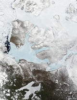
Banks Island
Encyclopedia
One of the larger members of the Canadian Arctic Archipelago
, Banks Island is situated in the Inuvik Region
of the Northwest Territories
, Canada
. It is separated from Victoria Island to its east by the Prince of Wales Strait
and from the mainland by Amundsen Gulf
to its south. The Beaufort Sea
lies to its west. To the northeast, M'Clure Strait separates the island from Prince Patrick Island
and Melville Island.
It was named "Banks Land" in 1820 by Sir William Edward Parry
in honour of Sir Joseph Banks
. However, during the exploration of the area by Robert McClure
(1850–1854) the island was marked on their maps as "Baring Island".
The only permanent settlement on the island, Sachs Harbour
or Ikhuak, an Inuvialuit
hamlet, is on the southwest coast. Two federal Migratory Bird Sanctuaries were founded on the island in 1961. The island is treeless, with the tallest plant, the Arctic Willow, growing occasionally to about the height of a person's knee but usually standing no taller than 10 cm (3.9 in).
Banks Island covers an area 70028 km² (27,038 sq mi) and it is the world's 24th largest island and Canada's fifth largest island. It is about 380 km (236.1 mi) long, and at its widest point at the northern end, 290 km (180.2 mi) across. The highest point of the island is in the south, Durham Heights and rises to about 730 m (2,395 ft). It is part of the Canadian Arctic Archipelago, and had a population of 114 in 2001, all in Sachs Harbour. Banks Island is home to two thirds of the world's population of lesser snow geese
, which make their way across the Amundsen Gulf from the mainland. There is an annual goose hunt in the spring out of Sachs Harbour. The island is part of the tundra
world biome
, which has extremely cold winters. The island is home to barren-ground caribou
, polar bear
s, muskoxen, and birds such as robins
and swallow
s. Over 68,000 muskoxen live on the island, the majority of the world's population.
The Aulavik National Park
of Canada, a fly-in park, protects about 12274 km² (4,739 sq mi) of Arctic
lowlands at the northern end of the island. The park has the highest concentration of muskoxen on earth, and is home to the endangered peary caribou
. The Thomsen River
runs through the park, and is the northernmost navigable river (by canoe
) in North America
. Ptarmigan and raven
s are considered the only year-round birds in the park, although 43 species make seasonal use of the area.
The first confirmed grizzly–polar bear hybrid found in the wild was shot on Banks Island in April 2006, near Sachs Harbour.
archeologists looking for the HMS Investigator
found it fifteen minutes after they started a sonar
scan of Banks Island, Mercy Bay
, Northwest Territories
. The archeology crew has no plans to raise the ship. They will do a thorough sonar scan of the area, then send a Remotely Operated Vehicle
.
Canadian Arctic Archipelago
The Canadian Arctic Archipelago, also known as the Arctic Archipelago, is a Canadian archipelago north of the Canadian mainland in the Arctic...
, Banks Island is situated in the Inuvik Region
Inuvik Region, Northwest Territories
The Inuvik Region is one of five administrative regions in the Northwest Territories. The region consists of eight communities with the regional office situated in Inuvik...
of the Northwest Territories
Northwest Territories
The Northwest Territories is a federal territory of Canada.Located in northern Canada, the territory borders Canada's two other territories, Yukon to the west and Nunavut to the east, and three provinces: British Columbia to the southwest, and Alberta and Saskatchewan to the south...
, Canada
Canada
Canada is a North American country consisting of ten provinces and three territories. Located in the northern part of the continent, it extends from the Atlantic Ocean in the east to the Pacific Ocean in the west, and northward into the Arctic Ocean...
. It is separated from Victoria Island to its east by the Prince of Wales Strait
Prince of Wales Strait
The Prince of Wales Strait is a strait in the Northwest Territories of Canada separating Banks Island to the northwest from Victoria Island to the southeast. It extends from Viscount Melville Sound in the northeast to Amundsen Gulf in the southwest. From late winter it is filled by ice that usually...
and from the mainland by Amundsen Gulf
Amundsen Gulf
Amundsen Gulf is a gulf located in Canadian Northwest Territories, between Banks Island and Victoria Island and the mainland . It is approximately in length and about across where it meets the Beaufort Sea....
to its south. The Beaufort Sea
Beaufort Sea
The Beaufort Sea is a marginal sea of the Arctic Ocean, located north of the Northwest Territories, the Yukon, and Alaska, west of Canada's Arctic islands. The sea is named after hydrographer Sir Francis Beaufort...
lies to its west. To the northeast, M'Clure Strait separates the island from Prince Patrick Island
Prince Patrick Island
A member of the Canadian Arctic Archipelago, Prince Patrick Island is the westernmost of the Queen Elizabeth Islands in the Northwest Territories of Canada. The area of the island is , making it the 55th largest island in the world and Canada's 14th largest island...
and Melville Island.
It was named "Banks Land" in 1820 by Sir William Edward Parry
William Edward Parry
Sir William Edward Parry was an English rear-admiral and Arctic explorer, who in 1827 attempted one of the earliest expeditions to the North Pole...
in honour of Sir Joseph Banks
Joseph Banks
Sir Joseph Banks, 1st Baronet, GCB, PRS was an English naturalist, botanist and patron of the natural sciences. He took part in Captain James Cook's first great voyage . Banks is credited with the introduction to the Western world of eucalyptus, acacia, mimosa and the genus named after him,...
. However, during the exploration of the area by Robert McClure
Robert McClure
Sir Robert John Le Mesurier McClure was an Irish explorer of the Arctic.In 1854, he was the first to transit the Northwest Passage , as well as the first to circumnavigate the Americas.-Early life and career:He was born at Wexford, in Ireland, the posthumous son of one of Abercrombie's captains,...
(1850–1854) the island was marked on their maps as "Baring Island".
The only permanent settlement on the island, Sachs Harbour
Sachs Harbour, Northwest Territories
Sachs Harbour is a hamlet located in the Inuvik Region of the Northwest Territories, Canada. Situated on the southwestern coast of Banks Island in the Inuvialuit Settlement Region, the population according to the 2006 census count was 122 people. The two principal languages in the town are...
or Ikhuak, an Inuvialuit
Inuvialuit
The Inuvialuit or Western Canadian Inuit are Inuit people who live in the western Canadian Arctic region. They, like all other Inuit, are descendants of the Thule who migrated eastward from Alaska...
hamlet, is on the southwest coast. Two federal Migratory Bird Sanctuaries were founded on the island in 1961. The island is treeless, with the tallest plant, the Arctic Willow, growing occasionally to about the height of a person's knee but usually standing no taller than 10 cm (3.9 in).
Banks Island covers an area 70028 km² (27,038 sq mi) and it is the world's 24th largest island and Canada's fifth largest island. It is about 380 km (236.1 mi) long, and at its widest point at the northern end, 290 km (180.2 mi) across. The highest point of the island is in the south, Durham Heights and rises to about 730 m (2,395 ft). It is part of the Canadian Arctic Archipelago, and had a population of 114 in 2001, all in Sachs Harbour. Banks Island is home to two thirds of the world's population of lesser snow geese
Snow Goose
The Snow Goose , also known as the Blue Goose, is a North American species of goose. Its name derives from the typically white plumage. The genus of this bird is disputed...
, which make their way across the Amundsen Gulf from the mainland. There is an annual goose hunt in the spring out of Sachs Harbour. The island is part of the tundra
Tundra
In physical geography, tundra is a biome where the tree growth is hindered by low temperatures and short growing seasons. The term tundra comes through Russian тундра from the Kildin Sami word tūndâr "uplands," "treeless mountain tract." There are three types of tundra: Arctic tundra, alpine...
world biome
Biome
Biomes are climatically and geographically defined as similar climatic conditions on the Earth, such as communities of plants, animals, and soil organisms, and are often referred to as ecosystems. Some parts of the earth have more or less the same kind of abiotic and biotic factors spread over a...
, which has extremely cold winters. The island is home to barren-ground caribou
Barren-ground Caribou
Barren-ground Caribou is a subspecies of the caribou that is found mainly in the Canadian territories Nunavut and the Northwest Territories and western Greenland. It sometimes includes the similar porcupine caribou, in which case the barren-ground caribou also is found in Alaska...
, polar bear
Polar Bear
The polar bear is a bear native largely within the Arctic Circle encompassing the Arctic Ocean, its surrounding seas and surrounding land masses. It is the world's largest land carnivore and also the largest bear, together with the omnivorous Kodiak Bear, which is approximately the same size...
s, muskoxen, and birds such as robins
American Robin
The American Robin or North American Robin is a migratory songbird of the thrush family. It is named after the European Robin because of its reddish-orange breast, though the two species are not closely related, with the European robin belonging to the flycatcher family...
and swallow
Swallow
The swallows and martins are a group of passerine birds in the family Hirundinidae which are characterised by their adaptation to aerial feeding...
s. Over 68,000 muskoxen live on the island, the majority of the world's population.
The Aulavik National Park
Aulavik National Park
Aulavik National Park is a national park located on Banks Island in the Northwest Territories of Canada. It is known for its access to the Thomsen River, one of the most northerly navigable rivers in North America. The park is a fly-in park, and protects approximately of Arctic Lowlands at the...
of Canada, a fly-in park, protects about 12274 km² (4,739 sq mi) of Arctic
Arctic
The Arctic is a region located at the northern-most part of the Earth. The Arctic consists of the Arctic Ocean and parts of Canada, Russia, Greenland, the United States, Norway, Sweden, Finland, and Iceland. The Arctic region consists of a vast, ice-covered ocean, surrounded by treeless permafrost...
lowlands at the northern end of the island. The park has the highest concentration of muskoxen on earth, and is home to the endangered peary caribou
Peary Caribou
The Peary Caribou is a caribou subspecies found in the high Arctic islands of Canada's Nunavut and Northwest territories. They are the smallest of the North American caribou, with the females weighing an average of 60 kg and the males 110 kg...
. The Thomsen River
Thomsen River
The Thomsen River, located in the Northwest Territories of Canada, is the northernmost usable river of the country. It is famous for canoeing.It flows across Banks Island in the Canadian Arctic Archipelago, and flows northward through Aulavik National Park before it empties through the Castel Bay...
runs through the park, and is the northernmost navigable river (by canoe
Canoe
A canoe or Canadian canoe is a small narrow boat, typically human-powered, though it may also be powered by sails or small electric or gas motors. Canoes are usually pointed at both bow and stern and are normally open on top, but can be decked over A canoe (North American English) or Canadian...
) in North America
North America
North America is a continent wholly within the Northern Hemisphere and almost wholly within the Western Hemisphere. It is also considered a northern subcontinent of the Americas...
. Ptarmigan and raven
Raven
Raven is the common name given to several larger-bodied members of the genus Corvus—but in Europe and North America the Common Raven is normally implied...
s are considered the only year-round birds in the park, although 43 species make seasonal use of the area.
The first confirmed grizzly–polar bear hybrid found in the wild was shot on Banks Island in April 2006, near Sachs Harbour.
HMS Investigator
In July 2010, Parks CanadaParks Canada
Parks Canada , also known as the Parks Canada Agency , is an agency of the Government of Canada mandated to protect and present nationally significant natural and cultural heritage, and foster public understanding, appreciation, and enjoyment in ways that ensure their ecological and commemorative...
archeologists looking for the HMS Investigator
HMS Investigator (1848)
HMS Investigator was a merchant ship purchased in 1848 to search for Sir John Franklin's lost expedition. She made two voyages to the Arctic and had to be abandoned in 1853 after becoming trapped in the ice. Her wreckage was found in July 2010 on Banks Island, in the Beaufort Sea...
found it fifteen minutes after they started a sonar
Sonar
Sonar is a technique that uses sound propagation to navigate, communicate with or detect other vessels...
scan of Banks Island, Mercy Bay
Mercy Bay
Mercy Bay is a Canadian Arctic waterway in the Northwest Territories. It is a southern arm of M'Clure Strait on northeast Banks Island. The mouth of Castel Bay is less than to the west...
, Northwest Territories
Northwest Territories
The Northwest Territories is a federal territory of Canada.Located in northern Canada, the territory borders Canada's two other territories, Yukon to the west and Nunavut to the east, and three provinces: British Columbia to the southwest, and Alberta and Saskatchewan to the south...
. The archeology crew has no plans to raise the ship. They will do a thorough sonar scan of the area, then send a Remotely Operated Vehicle
Remotely operated vehicle
A remotely operated vehicle is a tethered underwater vehicle. They are common in deepwater industries such as offshore hydrocarbon extraction. An ROV may sometimes be called a remotely operated underwater vehicle to distinguish it from remote control vehicles operating on land or in the air. ROVs...
.