

Vehicle registration plates of Indiana
Encyclopedia
The U.S. state
of Indiana
first required its residents to register their motor vehicle
s and display government-provided license plates in 1913, with the law taking effect on July 1 of that year.
issued standard automobile license plates
bearing a one- or two-digit number identifying the county in which the vehicle is registered. These prefixes proceeded alphabetically, with prefixes greater than 92 reserved as overflow for the state's historically most-populous counties, Lake (94 and 96) and Marion (93, 95, 97, 98 and 99).
Individual license plate numbers are assigned sequentially in each licensing office. The numbers are usually in the format #A1234 or ##A1234, depending on whether the prefix is one or two digits. Special overflow consideration was given for Allen
and St. Joseph
Counties and, more recently, Hamilton
, Elkhart
, and Vanderburgh
Counties, which issued plates of the formats 2AB123, 71AB123, 29AB123, 20AB123, and 82AB123, respectively.
From 1981 through 2008, following the introduction of multi-year plates, plates numbered 1 through 99 were reissued annually; numbers 100 and higher were revalidated with decals.
In 2008, new white-on-dark-blue license plates with white county name decals (located in the top center of each plate) replaced the old county number system, used since 1963, with a new system of license plates bearing a format of 123A, 123AB, or 123ABC with the stars and torch that adorn the state flag
on the left quarter of the plate. For the first time since 1987, "INDIANA" is printed on the bottom of the plate.
In January 2007, Indiana started to issue new plates bearing the words "IN GOD WE TRUST
" on the left third as a no-cost alternative to the regular plate. Like Indiana's other specialty plates, this plate has two vertical letters and one to four numbers. The county number is, when applied, on a sticker at the bottom right corner, and, like the other specialty plates, it too is available on trucks
up to 11,000 lbs. gross weight.
While very popular, this plate was controversial as the American Civil Liberties Union
of Indiana claimed that it is a symbol of endorsement of a religion. After a lawsuit from the ACLU because the God plates were of no cost, unlike other specialty plates, the Indiana Court of Appeals
upheld the plates' constitutionality.
Marion County
93, 95, 97, 98, 99
Lake County
94, 96
U.S. state
A U.S. state is any one of the 50 federated states of the United States of America that share sovereignty with the federal government. Because of this shared sovereignty, an American is a citizen both of the federal entity and of his or her state of domicile. Four states use the official title of...
of Indiana
Indiana
Indiana is a US state, admitted to the United States as the 19th on December 11, 1816. It is located in the Midwestern United States and Great Lakes Region. With 6,483,802 residents, the state is ranked 15th in population and 16th in population density. Indiana is ranked 38th in land area and is...
first required its residents to register their motor vehicle
Motor vehicle
A motor vehicle or road vehicle is a self-propelled wheeled vehicle that does not operate on rails, such as trains or trolleys. The vehicle propulsion is provided by an engine or motor, usually by an internal combustion engine, or an electric motor, or some combination of the two, such as hybrid...
s and display government-provided license plates in 1913, with the law taking effect on July 1 of that year.
Passenger plates 1970 to present
| Image | First issued | Description | Slogan | Serial format | Serials issued | Notes |
|---|---|---|---|---|---|---|
| 1970 | Red serial on reflective white background | County-coded:
|
1970 marked the first year of staggered registration for Indiana. Instead of expiring on the last day of February each year, plates would now expire between January 31 and June 30, depending on the registrant's last name. Plates were valid through June 30, 1971. | |||
| 1971 | Blue serial on reflective white background | County-coded:
|
Plates were valid through June 30, 1972. | |||
| 1972 | Green serial on reflective white background | County-coded:
|
Plates were valid through June 30, 1973. | |||
| 1973 | Red serial on reflective white background | County-coded:
|
Plates were valid through June 30, 1974. | |||
 Wayne County Wayne CountyWayne County, Indiana Wayne County is a county located in the U.S. state of Indiana. As of the 2010 census, the population was 68,917. The county seat is Richmond.-History:... Issued 1974 Plate |
1974 | Black serial on reflective white background | County-coded:
|
Plates were valid through June 30, 1975. | ||
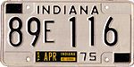
| 1975 | Blue serial on reflective white background | County-coded:
|
Plates were valid through June 30, 1976. | |||
| 1976 | Blue serial on reflective white, red and blue graphic background | Heritage State | County-coded:
|
This was Indiana's first graphic plate; the branch letter was pushed down to make room for the Minuteman figure. Plates were valid through June 30, 1977. | ||
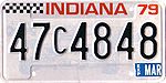
| 1977 | Green serial on reflective white, green and yellow background | County-coded:
|
Plates were valid through June 30, 1978. | |||
 Lawrence County Lawrence County, Indiana As of the census of 2000, there were 45,922 people, 18,535 households, and 13,141 families residing in the county. The population density was 102 people per square mile . There were 20,560 housing units at an average density of 46 per square mile... Issued 1978-79 Plate |
1978 | Black serial on reflective white, red and light blue background | County-coded:
|
Indianapolis 500 race cars in background. This issue is thought by some to be a tribute to Tony Hulman Tony Hulman Anton "Tony" Hulman, Jr. was a businessman from Terre Haute, Indiana who rescued the Indianapolis Motor Speedway in 1945 and made the Indianapolis 500 popular.... , owner of the Indianapolis Motor Speedway Indianapolis Motor Speedway The Indianapolis Motor Speedway, located in Speedway, Indiana in the United States, is the home of the Indianapolis 500-Mile Race and the Brickyard 400.... , who died in 1977; sample plates, normally numbered 00A0000 in most years, were numbered 00H0000 this year, lending some credence to this belief. Plates were valid through June 30, 1979. |
||
| 1979 | Brown serial on reflective white, yellow and brown background | 1779 George Rogers Clark George Rogers Clark George Rogers Clark was a soldier from Virginia and the highest ranking American military officer on the northwestern frontier during the American Revolutionary War. He served as leader of the Kentucky militia throughout much of the war... |
County-coded:
|
Awarded "Plate of the Year" for best new license plate of 1979 by the Automobile License Plate Collectors Association Automobile License Plate Collectors Association The Automobile License Plate Collectors Association is the largest such organization in the world. Founded in Rumney Depot, New Hampshire, United States, in 1953 and holding its first meeting in North Attleboro, Massachusetts, in 1954, its members have come from all 50 U.S... , the first and, to date, only time Indiana has been so honored. Plates were valid through June 30, 1980. |
||
| 1980 | Black serial on reflective white, yellow, orange and red background | County-coded:
|
Final annual issue for Indiana. Plates were valid through June 30, 1981. | |||
 Clark County Issued 1981-84 Plate |
1981 | Brown serial on reflective white, light and dark brown and black graphic background | County-coded:
|
First multi-year plate in Indiana since 1955, and the first to be renewed with decals (except for plates with numbers up to and including 100, which were reissued annually). Plates were valid until June 30, 1984. | ||
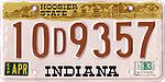
| 1984 | Black serial on reflective white, yellow, green and red background | Wander Indiana | County-coded:
|
Staggered registration expanded to January–October with 1987 expiration. Plates were valid through October 31, 1987. | ||
 Spencer County Spencer CountySpencer County, Indiana As of the census of 2000, there were 20,391 people, 7,569 households, and 5,752 families residing in the county. The population density was 51 people per square mile . There were 8,333 housing units at an average density of 21 per square mile... Issued 1987-90 Plate |
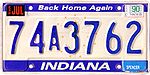
1987 | Blue serial on reflective blue, white and gold background | Back Home Again | County-coded:
|
Small white-on-blue county name decal added to lower right corner; hard to read from the start, most were illegible within a year. Plates were valid through October 31, 1990. | |
 Hamilton County Hamilton County, Indiana Hamilton County is a county located in the U.S. state of Indiana. Census 2010 recorded a population of 274,569. The county seat is Noblesville.... Issued 1990-92 Plate |
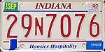
1990 | Red serial on reflective white background | Hoosier Hospitality | County-coded:
|
Small white-on-blue county name decal continues as on Back Home Again issue. Plates were valid through October 31, 1993. | |
 Spencer County Spencer CountySpencer County, Indiana As of the census of 2000, there were 20,391 people, 7,569 households, and 5,752 families residing in the county. The population density was 51 people per square mile . There were 8,333 housing units at an average density of 21 per square mile... Issued 1993-97 Plate |
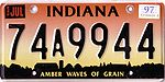
1993 | Black serial on reflective red, yellow and black background | Amber Waves of Grain | County-coded:
|
Replacement cycle moves from 3 to 5 years. Early-issued plates may have a yellow-on-black county name decal in the lower-right corner; this is dropped in most counties before the end of 1993. Plates were valid through October 31, 1998. | |
 Noble County Noble County, Indiana As of the census of 2000, there were 46,275 people, 16,696 households, and 12,288 families residing in the county. The population density was 113 people per square mile . There were 18,233 housing units at an average density of 44 per square mile... Single-letter 1998-2003 Plate 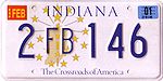 Allen County Allen CountyAllen County, Indiana As of the census of 2000, there were 331,849 people, 128,745 households, and 86,259 families residing in the county. The population density was 505 people per square mile . There were 138,905 housing units at an average density of 211 per square mile... Double-letter 1998-2003 Plate |
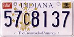
1998 | Dark blue serial on reflective white background, gold state outline and coat of arms - Indiana and Crossroads of America Printed in dark blue. | The Crossroads of America | County-coded:
|
Final embossed plate for Indiana. Plates were valid through October 31, 2003. | |
 Daviess County Daviess County, Indiana Daviess County is a county located in the U.S. state of Indiana. As of 2010, the population was 31,648. The county seat is Washington. Daviess County switched to the Central Time Zone on April 2, 2006. It has returned to the Eastern Time Zone as of November 4, 2007.- History :Daviess County was... Single Large-letter 2003-2008 Plate 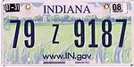 Tippecanoe County Tippecanoe County, Indiana Tippecanoe County is a county located in the northwest quadrant of the U.S. state of Indiana. It was created in 1826 from Wabash County. It is part of the Lafayette, Indiana, Metropolitan Statistical Area.... Single Small-letter 2003-2008 Plate 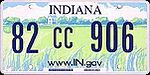 Vanderburgh County Vanderburgh County, Indiana As of the census of 2000, there were 171,922 people, 70,623 households, and 44,421 families residing in the county. The population density was 733 people per square mile . There were 76,300 housing units at an average density of 325 per square mile... Single-letter 2003-2008 Plate |
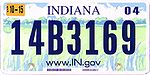
2003 | dark blue on reflective farm scene graphic | www.IN.gov | County-coded, with variable number of digits following letter:
|
Earlier plates used a larger serial font that included full-height letters. The original design was to have "Back Home Again," but was replaced with the state website. This plate used a serial that was screened on and is completely flat. All previous Indiana plates were embossed. Plates were valid through October 31, 2008. | |
Knox County Knox County, Indiana As of the census of 2000, there were 39,256 people, 15,552 households, and 10,139 families residing in the county. The population density was 76 people per square mile . There were 17,305 housing units at an average density of 34 per square mile... Tagged "In God We Trust" Plate |
2007 | optional type: white on dark blue with flag of the United States Flag of the United States The national flag of the United States of America consists of thirteen equal horizontal stripes of red alternating with white, with a blue rectangle in the canton bearing fifty small, white, five-pointed stars arranged in nine offset horizontal rows of six stars alternating with rows... motif and numerical county sticker in lower right corner, although some plates do not have county sticker. |
In God We Trust | AB 1234 (variable number of digits following letters); formatted like a specialty plate. | ||
 Four Gibson County Gibson County, Indiana Gibson County is a county located in the southwestern part of the U.S. state of Indiana and is included in the Evansville, Indiana–Kentucky Metropolitan Statistical Area. As of 2010, the population was 33,503. The county seat is Princeton.-Geography:... 2008-2013 Plate Types |
2008 | White on dark blue with white Indiana state flag Flag of Indiana The flag of Indiana was designed by Paul Hadley and officially adopted by the state of Indiana on May 31, 1917. It was the state's first official flag and has remained unchanged since then except for the creation of a statute to standardize the production of the flag.-History:To commemorate the... on left and sticker of county name and number on top |
none | Standard Version 123A, 123AB or 123ABC Grandfathered Version 00A0, 00A00 or 00A000 Handicapped Plates 2008-2010: 123456 2010>: D123A, D123AB National Guard Plates NG123A |
Serials not issued sequentially. Letters or combinations of letters are unique to a particular county. |
Issued concurrently with "In God We Trust" base. Staggered registration once again expanded to include all twelve months of the calendar year; four dates, the 7th, 14th, 21st and 28th of each month, are used (except in January and December). Grandfathered Version are laid out by county coding depending on demand for them. Some counties may only use single suffix numbers while others may use as much as three. |
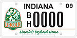 |
optional type: black on white with logo at left |
Lincoln's Boyhood Home | BF1234 BH1234 |
Aside from this and the In God We Trust Plates, there are approximately 70 other various organizations, schools, and other entities that offer plates using the same format but come with a $15 organizational fee. See Indiana Plate Types for further details. |
New Plate Prefixing
Starting in 2010 special plates such as the handicapped, POW, National Guard, Disabled American Veteran that use the background of the standard plates will no longer use just numbers. Instead they will now use a predetermined prefix three mumbers and one or two suffix letters depending on if they have one or two prefix numbers. In all the max total characters will amount to six.- Handicapped - D123A or D123AB
- Disabled American Veteran - DH123A or DF123A
- Ex-Prisoner of War - PW123A
- National Guard - NG123A
- Purple Heart - PH123A
County coding
From 1963 through 2008, the Indiana Bureau of Motor VehiclesDepartment of Motor Vehicles
In the United States of America, a Department of Motor Vehicles is a state-level government agency that administers vehicle registration and driver licensing. Similar departments exist in Canada...
issued standard automobile license plates
Vehicle registration plate
A vehicle registration plate is a metal or plastic plate attached to a motor vehicle or trailer for official identification purposes. The registration identifier is a numeric or alphanumeric code that uniquely identifies the vehicle within the issuing region's database...
bearing a one- or two-digit number identifying the county in which the vehicle is registered. These prefixes proceeded alphabetically, with prefixes greater than 92 reserved as overflow for the state's historically most-populous counties, Lake (94 and 96) and Marion (93, 95, 97, 98 and 99).
Individual license plate numbers are assigned sequentially in each licensing office. The numbers are usually in the format #A1234 or ##A1234, depending on whether the prefix is one or two digits. Special overflow consideration was given for Allen
Allen County, Indiana
As of the census of 2000, there were 331,849 people, 128,745 households, and 86,259 families residing in the county. The population density was 505 people per square mile . There were 138,905 housing units at an average density of 211 per square mile...
and St. Joseph
St. Joseph County, Indiana
As of the census of 2000, there were 265,559 people, 100,743 households, and 66,792 families residing in the county. The population density was 581 people per square mile . There were 107,013 housing units at an average density of 234 per square mile...
Counties and, more recently, Hamilton
Hamilton County, Indiana
Hamilton County is a county located in the U.S. state of Indiana. Census 2010 recorded a population of 274,569. The county seat is Noblesville....
, Elkhart
Elkhart County, Indiana
Elkhart County is a county in the U.S. state of Indiana. Much of the county is in the Elkhart-Goshen Metropolitan Statistical Area, which in turn is part of the South Bend-Elkhart-Mishawaka Combined Statistical Area...
, and Vanderburgh
Vanderburgh County, Indiana
As of the census of 2000, there were 171,922 people, 70,623 households, and 44,421 families residing in the county. The population density was 733 people per square mile . There were 76,300 housing units at an average density of 325 per square mile...
Counties, which issued plates of the formats 2AB123, 71AB123, 29AB123, 20AB123, and 82AB123, respectively.
From 1981 through 2008, following the introduction of multi-year plates, plates numbered 1 through 99 were reissued annually; numbers 100 and higher were revalidated with decals.
In 2008, new white-on-dark-blue license plates with white county name decals (located in the top center of each plate) replaced the old county number system, used since 1963, with a new system of license plates bearing a format of 123A, 123AB, or 123ABC with the stars and torch that adorn the state flag
Flag of Indiana
The flag of Indiana was designed by Paul Hadley and officially adopted by the state of Indiana on May 31, 1917. It was the state's first official flag and has remained unchanged since then except for the creation of a statute to standardize the production of the flag.-History:To commemorate the...
on the left quarter of the plate. For the first time since 1987, "INDIANA" is printed on the bottom of the plate.
In January 2007, Indiana started to issue new plates bearing the words "IN GOD WE TRUST
In God We Trust
"In God We Trust" was adopted as the official motto of the United States in 1956. It is also the motto of the U.S. state of Florida. The Legality of this motto has been questioned because of the United States Constitution forbidding the government to make any law respecting the establishment of a...
" on the left third as a no-cost alternative to the regular plate. Like Indiana's other specialty plates, this plate has two vertical letters and one to four numbers. The county number is, when applied, on a sticker at the bottom right corner, and, like the other specialty plates, it too is available on trucks
Pickup truck
A pickup truck is a light motor vehicle with an open-top rear cargo area .-Definition:...
up to 11,000 lbs. gross weight.
While very popular, this plate was controversial as the American Civil Liberties Union
American Civil Liberties Union
The American Civil Liberties Union is a U.S. non-profit organization whose stated mission is "to defend and preserve the individual rights and liberties guaranteed to every person in this country by the Constitution and laws of the United States." It works through litigation, legislation, and...
of Indiana claimed that it is a symbol of endorsement of a religion. After a lawsuit from the ACLU because the God plates were of no cost, unlike other specialty plates, the Indiana Court of Appeals
Indiana Court of Appeals
The Indiana Court of Appeals is the intermediate-level appellate court for the state of Indiana. It is the successor to the Indiana Appellate Court.-History:...
upheld the plates' constitutionality.
County Numbers
Indiana uses a numerical county-coding scheme to indicate the county of registration. The county code is displayed on a black on white sticker placed on the lower right corner of speciality plates like the In God we Trust plate shown above while long sticker with both the county number and name adorns the standard plates.- From the 1960s to 2008, the Indiana plate consisted of the county number, a letter and one to four numbers.
List of county numbers
- 01 - AdamsAdams County, IndianaAdams County lies in northeastern Indiana in the United States and shares its eastern border with Ohio. It was officially established in 1836. The county seat is Decatur....
- 02 - AllenAllen County, IndianaAs of the census of 2000, there were 331,849 people, 128,745 households, and 86,259 families residing in the county. The population density was 505 people per square mile . There were 138,905 housing units at an average density of 211 per square mile...
- 03 - BartholomewBartholomew County, IndianaBartholomew County is a county located in the U.S. state of Indiana, and determined by the U.S. Census Bureau to include the mean center of U.S. population in 1900. As of 2010, the population was 76,794...
- 04 - BentonBenton County, IndianaBenton County is located along in the northwest part of the U.S. state of Indiana, along the border with Illinois. As of 2010, the county's population was 8,854. It contains six incorporated towns as well as several small unincorporated settlements; it is also divided into 11 townships which...
- 05 - BlackfordBlackford County, IndianaBlackford County is located in the east central portion of the U.S. state of Indiana. The county is named for Judge Isaac Blackford, who was the first speaker of the Indiana General Assembly and a long-time chief justice of the Indiana Supreme Court. Created in 1838, Blackford County is divided...
- 06 - BooneBoone County, IndianaAs of the census of 2000, there were 46,107 people, 17,081 households, and 12,810 families residing in the county. The population density was 109 people per square mile . There were 17,929 housing units at an average density of 42 per square mile...
- 07 - BrownBrown County, IndianaBrown County is a county located in the U.S. state of Indiana. As of 2010, the population is 15,242. The county seat is Nashville.- History :...
- 08 - CarrollCarroll County, IndianaCarroll County is a county located in the U.S. state of Indiana. As of 2010, the population was 20,155. The county seat is Delphi.Carroll County is part of the Lafayette, Indiana, Metropolitan Statistical Area.- History :...
- 09 - CassCass County, IndianaAs of the census of 2000, there were 40,930 people, 15,715 households, and 10,921 families residing in the county. The population density was 99 people per square mile . There were 16,620 housing units at an average density of 40 per square mile...
- 10 - ClarkClark County, IndianaClark County is a county located in the U.S. state of Indiana, located directly across the Ohio River from Louisville, Kentucky. At the 2010 Census, the population was 110,232. The county seat is Jeffersonville. Clarksville is also a major city in the county...
- 11 - ClayClay County, IndianaClay County is a county located in the U.S. state of Indiana. As of 2010, the population was 26,890. The county seat is Brazil. Clay County is included in the Terre Haute, Indiana, Metropolitan Statistical Area.- History :Clay County was formed in 1825...
- 12 - ClintonClinton County, IndianaAs of the census of 2000, there were 33,866 people, 12,545 households, and 9,057 families residing in the county. The population density was 84 people per square mile . There were 13,267 housing units at an average density of 33 per square mile...
- 13 - CrawfordCrawford County, IndianaCrawford County is a county located in the U.S. state of Indiana. As of 2010, the population was 10,713. The county seat is English.-Geography:...
- 14 - DaviessDaviess County, IndianaDaviess County is a county located in the U.S. state of Indiana. As of 2010, the population was 31,648. The county seat is Washington. Daviess County switched to the Central Time Zone on April 2, 2006. It has returned to the Eastern Time Zone as of November 4, 2007.- History :Daviess County was...
- 15 - DearbornDearborn County, IndianaDearborn County is a county located in the U.S. state of Indiana. As of 2010, the population was 50,047. It is part of the Cincinnati-Northern Kentucky metropolitan area. The county seat is Lawrenceburg.-History:...
- 16 - DecaturDecatur County, IndianaAs of the census of 2000, there were 24,555 people, 9,389 households, and 6,882 families residing in the county. The population density was 66 people per square mile . There were 9,992 housing units at an average density of 27 per square mile...
- 17 - DeKalbDeKalb County, IndianaDeKalb County is a county located in the U.S. state of Indiana. Named for Revolutionary War hero Johann, Baron de Kalb , the county was created by the Indiana legislature in 1835 and organized in 1837. As of 2010, the population was 42,223...
- 18 - DelawareDelaware County, IndianaAs of the census of 2000, there were 118,769 people, 47,131 households, and 29,692 families residing in the county. The population density was 302 people per square mile . There were 51,032 housing units at an average density of 130 per square mile...
- 19 - DuboisDubois County, IndianaDubois County is a county located in the U.S. state of Indiana. The county seat is Jasper. As of 2010, the population was 41,889.Dubois County is part of the Jasper Micropolitan Statistical Area.-History:...
- 20 - ElkhartElkhart County, IndianaElkhart County is a county in the U.S. state of Indiana. Much of the county is in the Elkhart-Goshen Metropolitan Statistical Area, which in turn is part of the South Bend-Elkhart-Mishawaka Combined Statistical Area...
- 21 - FayetteFayette County, Indiana-2010 Census Data:As of the census of 2010, there were 24,277 people and 9,719 households residing in the county. The population density was 113 people per square mile . There were 10,898 housing units at an average density of 51 per square mile...
- 22 - FloydFloyd County, IndianaFloyd County is a county located in the U.S. state of Indiana. As of 2010, the population was 74,578. The county seat is New Albany. Floyd County is the county with the second smallest land area in the entire state...
- 23 - FountainFountain County, IndianaFountain County lies in the western part of the U.S. state of Indiana on the east side of the Wabash River. The county was officially established in 1826 and was the 53rd in Indiana. The county seat is Covington....
- 24 - FranklinFranklin County, IndianaAs of the census of 2000, there were 22,151 people, 7,868 households, and 6,129 families residing in the county. The population density was 57 people per square mile . There were 8,596 housing units at an average density of 22 per square mile...
- 25 - FultonFulton County, IndianaAs of the census of 2000, there were 20,511 people, 8,082 households, and 5,738 families residing in the county. The population density was 56 people per square mile . There were 9,123 housing units at an average density of 25 per square mile...
- 26 - GibsonGibson County, IndianaGibson County is a county located in the southwestern part of the U.S. state of Indiana and is included in the Evansville, Indiana–Kentucky Metropolitan Statistical Area. As of 2010, the population was 33,503. The county seat is Princeton.-Geography:...
- 27 - GrantGrant County, IndianaGrant County is a county located in the U.S. state of Indiana. As of the 2010 census, the population was 70,061. The county seat is Marion. Important paleontological discoveries dating from the Pliocene epoch have been made at Pipe Creek Sinkhole in Grant County.-Geography:According to the 2010...
- 28 - GreeneGreene County, IndianaGreene County is a county located in the U.S. state of Indiana, and determined by the U.S. Census Bureau to include the mean center of U.S. population in 1930. As of 2010, the population was 33,165. The county seat is Bloomfield....
- 29 - HamiltonHamilton County, IndianaHamilton County is a county located in the U.S. state of Indiana. Census 2010 recorded a population of 274,569. The county seat is Noblesville....
- 30 - HancockHancock County, IndianaHancock County is a county located in the U.S. state of Indiana. As of 2010, the population was 70,002. The county seat is Greenfield.-Geography:...
- 31 - HarrisonHarrison County, IndianaHarrison County is a county located in the far southern part of the U.S. state of Indiana along the Ohio River. It is divided into twelve townships, and the county seat is Corydon, the former capital of Indiana. The county is part of the larger Louisville/Jefferson County, KY–IN Metropolitan...
- 32 - HendricksHendricks County, Indiana- Towns :*Amo*Avon*Brownsburg*Clayton*Coatesville*Danville*Lizton*North Salem*Pittsboro*Plainfield*Stilesville-Townships:*Brown*Center*Clay*Eel River*Franklin*Guilford*Liberty*Lincoln*Marion*Middle*Union*Washington-Further reading:...
- 33 - HenryHenry County, IndianaAs of the census of 2000, there were 48,508 people, 19,486 households, and 13,971 families residing in the county. The population density was 124 people per square mile . There were 20,592 housing units at an average density of 52 per square mile...
- 34 - HowardHoward County, IndianaHoward County is one of 92 counties in the U.S. state of Indiana. It is part of the Kokomo, Indiana, Metropolitan Statistical Area, which consists of Howard and Tipton counties. Originally named Richardville County, it was rechristened in 1844 to commemorate General Tilghman Ashurst Howard. As of...
- 35 - HuntingtonHuntington County, IndianaHuntington County is a county located in the U.S. state of Indiana. The county seat and lone city is Huntington. According to Census 2010, the population was 37,124.-Geography:...
- 36 - JacksonJackson County, IndianaJackson County is a county located in the U.S. state of Indiana. As of 2010, the population was 42,376. The county seat is Brownstown.-History:...
- 37 - JasperJasper County, IndianaAs of the census of 2000, there were 30,043 people, 10,686 households, and 8,217 families residing in the county. The population density was 54 people per square mile . There were 11,236 housing units at an average density of 20 per square mile...
- 38 - JayJay County, IndianaAs of the census of 2000, there were 21,806 people, 8,405 households, and 6,017 families residing in the county. The population density was 57 people per square mile . There were 9,074 housing units at an average density of 24 per square mile...
- 39 - JeffersonJefferson County, IndianaJefferson County is a county located in the U.S. state of Indiana. As of 2010, the population was 32,428. The county seat is Madison.-History:Jefferson County was formed in 1811...
- 40 - JenningsJennings County, IndianaJennings County is a county located in the U.S. state of Indiana. As of 2010, the population was 28,525. The county seat is Vernon.-History:...
- 41 - JohnsonJohnson County, IndianaAs of the census of 2000, there were 115,209 people, 42,434 households, and 31,613 families residing in the county. The population density was 360 people per square mile . There were 45,095 housing units at an average density of 141 per square mile...
- 42 - KnoxKnox County, IndianaAs of the census of 2000, there were 39,256 people, 15,552 households, and 10,139 families residing in the county. The population density was 76 people per square mile . There were 17,305 housing units at an average density of 34 per square mile...
- 43 - KosciuskoKosciusko County, IndianaKosciusko County is a county located in the U.S. state of Indiana. Census 2010 recorded the population at 77,358. The county seat is Warsaw.The county was formed in 1836. It was named after the Polish general Tadeusz Kościuszko, who served in the American Revolutionary War, and then returned to...
- 44 - LaGrangeLaGrange County, IndianaLaGrange County is a county located in the U.S. state of Indiana and in the Northern Indiana region known as Michiana. As of 2010, the population was 37,128. The county is located about east of South Bend, west of Toledo, Ohio, and northeast of Indianapolis. The area is well known for its large...
- 45 - LakeLake County, IndianaLake County is a county located in the U.S. state of Indiana. In 2010, its population was 496,005, making it Indiana's second-most populous county. The county seat is Crown Point. This county is part of Northwest Indiana and the Chicago metropolitan area. The county contains a mix of urban,...
- 46 - LaPorteLaPorte County, IndianaLaPorte County is a county located in the U.S. state of Indiana. As of 2010, the population was 111,467. The county seat is the city of La Porte. This county is part of the Chicago metropolitan area, Northwest Indiana and Michiana. The largest city is Michigan City...
- 47 - LawrenceLawrence County, IndianaAs of the census of 2000, there were 45,922 people, 18,535 households, and 13,141 families residing in the county. The population density was 102 people per square mile . There were 20,560 housing units at an average density of 46 per square mile...
- 48 - MadisonMadison County, IndianaAs of the census of 2000, there were 133,358 people, 53,052 households, and 36,234 families residing in the county. The population density was 295 people per square mile . There were 56,939 housing units at an average density of 126 per square mile...
- 49 - MarionMarion County, IndianaMarion County is a county located in the U.S. state of Indiana. Census 2010 recorded a population of 903,393, making it the largest county in the state and 55th most populated county in the country, greater than the population of six states. The county seat is Indianapolis, the state capital and...
- 50 - MarshallMarshall County, IndianaAs of the census of 2000, there were 45,128 people, 16,519 households, and 12,191 families residing in the county. The population density was 102 people per square mile . There were 18,099 housing units at an average density of 41 per square mile...
- 51 - MartinMartin County, IndianaAs of the census of 2000, there were 10,369 people, 4,183 households, and 2,877 families residing in the county. The population density was 31 people per square mile . There were 4,729 housing units at an average density of 14 per square mile...
- 52 - MiamiMiami County, IndianaAs of the census of 2000, there were 36,082 people, 13,716 households, and 9,806 families residing in the county. The population density was 96 people per square mile . There were 15,299 housing units at an average density of 41 per square mile...
- 53 - MonroeMonroe County, IndianaAs of the census of 2010, there were 137,974 people, 46,898 households, and 24,715 families residing in the county. The population density was 306 people per square mile . There were 50,846 housing units at an average density of 129 per square mile...
- 54 - MontgomeryMontgomery County, IndianaMontgomery County is a county located in the U.S. state of Indiana. As of 2010, the population was 38,124. The county seat is Crawfordsville-Early history and settlement:...
- 55 - MorganMorgan County, IndianaMorgan County is a county located in the U.S. state of Indiana. As of 2010, the population was 68,894. The county seat is Martinsville. Morgan is one of seven counties contiguous to Marion County, and is located between Indianapolis, in Marion County, and Bloomington, located in Monroe County...
- 56 - NewtonNewton County, IndianaNewton County is a county located in the U.S. state of Indiana. As of 2010, the population was 14,244. The county seat is Kentland.- History :...
- 57 - NobleNoble County, IndianaAs of the census of 2000, there were 46,275 people, 16,696 households, and 12,288 families residing in the county. The population density was 113 people per square mile . There were 18,233 housing units at an average density of 44 per square mile...
- 58 - OhioOhio County, IndianaAs of the census of 2000, there were 5,623 people, 2,201 households, and 1,586 families residing in the county. The population density was 65 people per square mile . There were 2,424 housing units at an average density of 28 per square mile...
- 59 - OrangeOrange County, IndianaAs of the census of 2000, there were 19,306 people, 7,621 households, and 5,342 families residing in the county. The population density was 48 people per square mile . There were 8,348 housing units at an average density of 21 per square mile...
- 60 - OwenOwen County, IndianaOwen County is a county located in the U.S. state of Indiana, and determined by the U.S. Census Bureau to include the mean center of U.S. population in 1920. As of 2010, the population was 21,575...
- 61 - ParkeParke County, IndianaParke County is a county in the western part of the U.S. state of Indiana. It was formed in 1821 out of a portion of Vigo County. The county seat is Rockville....
- 62 - PerryPerry County, IndianaPerry County is a county located in the southwestern part of the U.S. state of Indiana. As of 2010, the population was 19,338. The county seat is Tell City. It is the hilliest county as well as one of the most forested counties of in Indiana as it features more than of Hoosier National Forest...
- 63 - PikePike County, IndianaAs of the census of 2000, there were 12,837 people, 5,119 households, and 3,680 families residing in the county. The population density was 38 people per square mile . There were 5,611 housing units at an average density of 17 per square mile...
- 64 - PorterPorter County, IndianaPorter County is a county located in the U.S. state of Indiana. As of 2010, the population was 164,343. Much of the population growth has to do with the expansion of the Chicago Metropolitan Area eastward into Indiana. The county seat is Valparaiso...
- 65 - PoseyPosey County, IndianaAs of the census of 2000, there were 27,061 people, 10,205 households, and 7,612 families residing in the county. The population density was 66 people per square mile . There were 11,076 housing units at an average density of 27 per square mile...
- 66 - PulaskiPulaski County, IndianaAs of the census of 2000, there were 13,755 people, 5,170 households, and 3,779 families residing in the county. The population density was 32 people per square mile . There were 5,918 housing units at an average density of 14 per square mile...
- 67 - PutnamPutnam County, IndianaAs of the census of 2000, there were 36,019 people, 12,374 households, and 9,119 families residing in the county. The population density was 75 people per square mile . There were 13,505 housing units at an average density of 28 per square mile...
- 68 - RandolphRandolph County, IndianaRandolph County is a county located in the U.S. state of Indiana. As of 2010, the population was 26,171. The county seat is Winchester.-History:...
- 69 - RipleyRipley County, IndianaAs of the census of 2000, there were 26,523 people, 9,842 households, and 7,273 families residing in the county. The population density was 59 people per square mile . There were 10,482 housing units at an average density of 24 per square mile...
- 70 - RushRush County, IndianaAs of the census of 2000, there were 18,261 people, 6,923 households, and 5,046 families residing in the county. The population density was 45 people per square mile . There were 7,337 housing units at an average density of 18 per square mile...
- 71 - Saint JosephSt. Joseph County, IndianaAs of the census of 2000, there were 265,559 people, 100,743 households, and 66,792 families residing in the county. The population density was 581 people per square mile . There were 107,013 housing units at an average density of 234 per square mile...
- 72 - ScottScott County, IndianaAs of the census of 2000, there were 22,960 people, 8,832 households, and 6,491 families residing in the county. The population density was 121 people per square mile . There were 9,737 housing units at an average density of 51 per square mile...
- 73 - ShelbyShelby County, IndianaAs of the census of 2000, there were 43,445 people, 16,561 households, and 12,056 families residing in the county. The population density was 105 people per square mile . There were 17,633 housing units at an average density of 43 per square mile...
- 74 - SpencerSpencer County, IndianaAs of the census of 2000, there were 20,391 people, 7,569 households, and 5,752 families residing in the county. The population density was 51 people per square mile . There were 8,333 housing units at an average density of 21 per square mile...
- 75 - StarkeStarke County, IndianaStarke County is a county located in the U.S. state of Indiana. As of 2010, the population was 23,363. The county seat is Knox.-History:Starke County was created in 1835 and organized in 1850. It was named for Gen...
- 76 - SteubenSteuben County, IndianaSteuben County is a county located in the northeast corner of the U.S. state of Indiana. As of 2010, the population was 34,185. The county seat is Angola...
- 77 - SullivanSullivan County, IndianaSullivan County is a county located in the U.S. state of Indiana, and determined by the U.S. Census Bureau to include the mean center of U.S. population in 1940. As of 2010, the population was 21,475. The county seat is Sullivan. Sullivan County is included in the Terre Haute, Indiana,...
- 78 - SwitzerlandSwitzerland County, IndianaSwitzerland County is a county located in the U.S. state of Indiana. As of 2010, the population was 10,613. The county seat is Vevay.-History:Switzerland County was formed in 1814...
- 79 - TippecanoeTippecanoe County, IndianaTippecanoe County is a county located in the northwest quadrant of the U.S. state of Indiana. It was created in 1826 from Wabash County. It is part of the Lafayette, Indiana, Metropolitan Statistical Area....
- 80 - TiptonTipton County, IndianaTipton County is located in central Indiana, north of the state capital of Indianapolis. Before the arrival of non-indigenous settlers in the early 19th century, the area was inhabited by several Native American tribes. The county was officially established in 1844 and was one of the last Indiana...
- 81 - UnionUnion County, IndianaAs of the census of 2000, there were 7,349 people, 2,793 households, and 2,072 families residing in the county. The population density was 46 people per square mile . There were 3,077 housing units at an average density of 19 per square mile...
- 82 - VanderburghVanderburgh County, IndianaAs of the census of 2000, there were 171,922 people, 70,623 households, and 44,421 families residing in the county. The population density was 733 people per square mile . There were 76,300 housing units at an average density of 325 per square mile...
- 83 - VermillionVermillion County, IndianaVermillion County lies in western Indiana between the Illinois border and the Wabash River. It was officially established in 1824 and was the 50th Indiana county to be formed. It is included in the Terre Haute, Indiana, Metropolitan Statistical Area. The county seat is Newport.According to the 2010...
- 84 - VigoVigo County, IndianaVigo County is a county located along the western border of the U.S. state of Indiana. Vigo County is included in the Terre Haute, Indiana, Metropolitan Statistical Area. The county seat is Terre Haute....
- 85 - WabashWabash County, IndianaAs of the census of 2000, there were 34,960 people, 13,215 households, and 9,395 families residing in the county. The population density was 85 people per square mile . There were 14,034 housing units at an average density of 34 per square mile...
- 86 - WarrenWarren County, IndianaWarren County lies in western Indiana between the Illinois border and the Wabash River in the United States. Before the arrival of non-indigenous settlers in the early 19th century, the area was inhabited by several Native American tribes. The county was officially established in 1827 and...
- 87 - WarrickWarrick County, IndianaAs of the census of 2000, there were 52,383 people, 19,438 households, and 15,181 families residing in the county. The population density was 136 people per square mile . There were 20,546 housing units at an average density of 54 per square mile...
- 88 - WashingtonWashington County, IndianaWashington County is a county located in the U.S. state of Indiana. As of 2010, the population was 28,262. The county seat is Salem.Washington County is part of the Louisville/Jefferson County, KY–IN Metropolitan Statistical Area.-Early settlers:...
- 89 - WayneWayne County, IndianaWayne County is a county located in the U.S. state of Indiana. As of the 2010 census, the population was 68,917. The county seat is Richmond.-History:...
- 90 - WellsWells County, IndianaWells County is a county located in the U.S. state of Indiana. As of the 2010 census, the population was 27,636. The county seat is Bluffton.-Geography:...
- 91 - WhiteWhite County, IndianaAs of the census of 2000, there were 25,267 people, 9,727 households, and 7,090 families residing in the county. The population density was 50 people per square mile . There were 12,083 housing units at an average density of 24 per square mile...
- 92 - WhitleyWhitley County, IndianaAs of the census of 2000, there were 30,707 people, 11,711 households, and 8,607 families residing in the county. The population density was 92 people per square mile . There were 12,545 housing units at an average density of 37 per square mile...
Additional Prefixes
Under the previous licence plate system these 7 numbers were distributed among the two largest counties in Indiana.Marion County
Marion County, Indiana
Marion County is a county located in the U.S. state of Indiana. Census 2010 recorded a population of 903,393, making it the largest county in the state and 55th most populated county in the country, greater than the population of six states. The county seat is Indianapolis, the state capital and...
93, 95, 97, 98, 99
Lake County
Lake County, Indiana
Lake County is a county located in the U.S. state of Indiana. In 2010, its population was 496,005, making it Indiana's second-most populous county. The county seat is Crown Point. This county is part of Northwest Indiana and the Chicago metropolitan area. The county contains a mix of urban,...
94, 96
Renewal Date Tags
In the past Indiana colored its due date tags by month. Another change to the plate system is that there are only four colors of tags which are the same regardless of the month, whether it be January, June, or December, another change because Indiana used to only issue month tags from January to October. These are all found on the top left corner of an Indiana Plate based on the first three letters of the last name of the owner. Note: January tags are issued to company vehicles, based on the first three letters of the company name.- 01-07
- 02-07
- 03-07
- 04-07
- 05-07
- 06-07
- 07-07
- 08-07
- 09-07
- 10-07
- 11-07
- 12-07
- 01-14
- 02-14
- 03-14
- 04-14
- 05-14
- 06-14
- 07-14
- 08-14
- 09-14
- 10-14
- 11-14
- 12-14
- 01-21
- 02-21
- 03-21
- 04-21
- 05-21
- 06-21
- 07-21
- 08-21
- 09-21
- 10-21
- 11-21
- 12-21
- 01-28
- 02-28
- 03-28
- 04-28
- 05-28
- 06-28
- 07-28
- 08-28
- 09-28
- 10-28
- 11-28
- 12-28
External links
- Indiana license plates 1969-present
- Jacob's License Plate Website, the online home of the Jacob A. Newkirk Historic License Plate Collection (will close October 26, 2009 due to the shutdown of all Yahoo! GeoCities free web sites)
- Jacob's License Plate Blog, the new online home of the Jacob A. Newkirk Historic License Plate Collection